Mammoth Cave National Park, United States
Contents
- 1 Introduction The Mammoth Cave National Park (37°07'-37°17'N, 86°00'-86°17'W) is a World Heritage Site in the United States. Mammoth Cave National Park, in a karst limestone landscape in the state of Kentucky, has the world's longest and most faunistically diverse (Mammoth Cave National Park, United States) network of caves and underground passageways. The Park and its subterranean labyrinth of more than 550 surveyed kilometers of passageways host an unusual flora and fauna, including a large number of endangered cave-dependent species.
- 2 Geographical Location
- 3 Date and History of Establishment
- 4 Area
- 5 Land Tenure
- 6 Altitude
- 7 Physical Features
- 8 Climate
- 9 Vegetation
- 10 Fauna
- 11 Cultural Heritage
- 12 Local Human Population
- 13 Visitors and Visitor Facilities
- 14 Scientific Research and Facilities
- 15 Conservation Value
- 16 Conservation Management
- 17 IUCN Management Category
- 18 Further Reading
Introduction The Mammoth Cave National Park (37°07'-37°17'N, 86°00'-86°17'W) is a World Heritage Site in the United States. Mammoth Cave National Park, in a karst limestone landscape in the state of Kentucky, has the world's longest and most faunistically diverse (Mammoth Cave National Park, United States) network of caves and underground passageways. The Park and its subterranean labyrinth of more than 550 surveyed kilometers of passageways host an unusual flora and fauna, including a large number of endangered cave-dependent species.
Geographical Location
Located in Barren, Edmonson and Hart counties, in south-central Kentucky, 135 kilometers (km) south of Louisville, and northwest of Park City which lies within the Transition Zone of the Park: 37°07'-37°17'N, 86°00'-86°17'W.
Date and History of Establishment
- 1926: National park authorized under enabling legislation of the U.S. Congress (56 Statute 317)'
- 1941: Park fully established by 44 Statute 635. Kentucky ceded jurisdiction over park lands by an act approved in 1930: accepted 1944
- 1965: Exclusive jurisdiction over the remainder of the land accepted. Certain roads through the park are legally open to the public under Deed No.262 of 1945;
- 1988: Part of the area was endorsed by the Barren River Area Development District resolution of 24/10/1988. The State of Kentucky designated Big Woods old-growth forest a state natural area, Green River a wild and scenic river, and Green River and Mammoth Cave subsurface streams outstanding resource waters;
- 1990: Accepted as a Biosphere Reserve; greatly extended 1996 to cover the cave’s recharge area.
Area
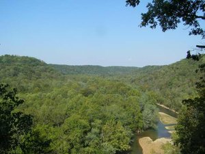 Mammoth Cave National Park. (Source: AIRNow, Kentucky Air Quality Conditions)
 National Park: 21,191 hectares (ha). The extended Biosphere Reserve area is 367,979 ha.
Land Tenure
The National Park core area is federally owned and is managed by the National Park Service (NPS). Southeast of it a transition zone of equal size which covers much of the cave’s recharge area is managed by a range of owners.
Altitude
Ranges from 180 meters (m) to 231 m.
Physical Features
The Park is situated on the Mammoth Cave Plateau and contains an area of karst of international importance. The core area is a dissected plateau called the Chester Upland, comprising sandstone-capped ridges which protect the underlying caverns, separated by limestone valleys pitted with sinkholes. It contains the longest cave system in the world, in a many-leveled labyrinth, with known passages extending for over 550 km. Most types of limestone cave formation are found here, including long passages with huge chambers, vertical shafts, stalagmites, stalactites and gypsum flowers and needles. On the surface there is a superb karst topography with largely subsurface drainage, sinkholes, cracks, fissures and springs. Groundwater flows from the extensive recharge areas on the plateau, southwest through the park's cave system to springs that discharge into the Green River. Erosion by the Green River and its tributaries, which formed this system, began over 25 million years ago and the old river meanders are now deeply incised.
The limestone rocks of Upper Mississippian age are highly soluble and contain fossils throughout, including brachiopods, crinoids and corals. The main series, in which the cave systems and karst landscape have developed, are the St. Louis, St. Genevieve and Paoli limestones of the Meramecian. The Chester Upland is capped by sandstones of the Upper Mississippian-Lower Pennsylvania periods. Structural dip in the north-west is about 5 m/km. The major soil types are those developed from limestone residuum and are either alfisols or ultisols. To the east, south and west of the park (included in the Transition Zone) is the Pennyroyal Plateau, separated from the upland by an escarpment. This is not capped by sandstone and has eroded to a lower level, with many sinkholes.
Climate
Conditions are humid temperate. Mean annual precipitation is 1,118 millimeters (mm) at an altitude of 205 m and practically all of it is in the form of rain as temperatures are generally above freezing during the day. The National Parks Conservation Association claims that this rainfall is ten times as acidic as the national average. The mean annual temperature is 13.6°C with a summer mean of 26.6°C and a winter mean of 1.7°C.
Vegetation
The surface vegetation includes 84 tree, 28 shrub and vine, 29 fern, 209 flower, 67 algae, 27 fungi and seven moss species. An inventory of the flora is included in the Biosphere Reserve nomination. Big Woods is reputed to be one of the largest and best remaining examples of the ancient forest of eastern North America that once covered Kentucky. This temperate deciduous oak-hickory forest is dominated by oaks including white, black and chestnut oaks, Quercus alba, Q. velutina, Q. prinus and hickories including pignut and mockernut, Carya glabra and C. tomentosa with some beech Fagus sp.,maples Acer spp., tulip tree Liriodendron tulipifera, ash Fraxinus sp. and eastern red cedar Juniperus virginiana.
Fauna
This is the most extensive and diverse cave ecosystem in the world, with over 200 species, mostly invertebrate, indigenous to the network of caves, with 42 species adapted to life in total darkness. The terrestrial vertebrates include 43 mammal, 207 bird, 37 reptile and 27 amphibian species. The age of the geological formations has contributed to the species richness of the cave fauna, the cave system being old enough to have communities from three karst regions and covering an area large enough for speciation to have occurred. Nowhere else do blind northern cave fish Amblyopsis spelaea (VU), Typhlichthus subterraneus and their spring cave-dwelling relative Chologaster agassizi co-exist. Resident endangered (IUCN Red List Criteria for Endangered) animal species include Indiana bat Myotis sodalis (EN), gray bat M. grisescens (EN), fanshell mussel Cyprogenia stegaria (CR), crackling pearly mussel Hemistema lata (CR), ring pink mussel Obovaria retusa (CR), rough pigtoe mussel Pleurobema plenum (CR), and clubshell mussel P. clava (CR). 45 other mussel species also inhabit the caves. In addition, the federally endangered bald eagle Haliaeetus leucocephalus has been observed wintering and may even be nesting in the park, and the uncommon red-cockaded woodpecker Picoides borealis has been seen there. Wild turkey Meleagris gallopavo and beaver Castor Canadensis have been successfully reintroduced.
Cultural Heritage
There are 1,008 identified prehistoric and historic archaeological sites in the park, representing almost 10,000 years of human history including the first evidence of organized horticulture on the continent. The museum collection contains more than 30,000 objects, including a Hercules steam engine and coach which are listed in the National Register of Historic Places. Additional listings include 28 structures and an archaeological site. Radiocarbon dating of cultural material indicates that prehistoric people entered Mammoth and other park caves almost 4,000 years ago to explore and mine cave minerals. Mammoth Cave was first recorded by Euro-Americans in the late 18th Century and saltpetre was mined for gunpowder between 1812 and 1819. The area became popular with tourists thereafter and was lightly settled during the 19th century. Guided tours began in 1916, and until 1926 when legislation to establish Mammoth Cave National Park was passed, the cave was operated as a tourist attraction by a succession of private owners.
Local Human Population
There are no permanent inhabitants in the core area. About 240 people live in the buffer zones with a further 1,500 in the transition area, including over 600 in Park City. Population density in the region surrounding the park is low (30 per square kilometer) and has remained stable for the past 20 years. Only 25% of the population is considered urban and no significant increase in urbanization is expected in the near future. Most people are engaged in agriculture, tourism or service industries.
Visitors and Visitor Facilities
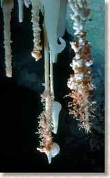 Spinder soda aragonite karst found in caves at Mammoth Cave National Park. (Source: NPS)
 Since a peak in 1979 of 1.6 million visitors, numbers remained stable into the 1980s, but have recently increased to about 2 million per annum. The summer months of June, July and August see over 60% of the annual total. Park headquarters and a visitors’ center are located at the historic entrance to Mammoth Cave. Guided tours of the caves are offered and there are commercial boat trips on Green River. There are 155 km of roads within the park and many hiking trails, including over 73 km in the remote areas. There are only two small ferries across the Green River so that resources in remoter areas remain untapped. Access is good and it is estimated that a third of all visitors do no more than drive through the park. There is a hotel, lodge and various cottages, restaurant and shopping facilities in the buffer zone. A further 2,000 motel rooms and over 7,500 campsite places are located within easy distance of the park.
Scientific Research and Facilities
Long-term hydrological and ecological research into karst systems is being carried out in the Mammoth Cave area, including the effects of water quality on the cave's biota. In particular, research into groundwater flow-pulse rates and modeling has been applied to the development of instrumentation packages for monitoring the physical and chemical properties of groundwater. Preliminary discussions on the international applications of this have been initiated and much research has already been carried out. A research facility and laboratory are available to visiting researchers. Partnerships with numerous agencies, organizations and universities exist: with Ball State University, University of Tennessee, Clemson University, Eastern Kentucky University, Western Kentucky University, Murray State University, University of Louisville, the Kentucky Nature Preserves Commission, Barren River Area Development District, and The Nature Conservancy, which offer opportunities for research, education and training.
Conservation Value
The Mammoth Cave area is an internationally important area of karst, containing the longest cave system in the world, with known passages extending for over 550 km and containing most types of limestone cave formation. Over 200 species of animal are indigenous to the caves including several [[endangered (IUCN Red List Criteria for Endangered)] species] of blind fish, shrimp, bat and freshwater (Freshwater biomes) mussel. Big Woods, a temperate deciduous oak-hickory dominated forest, is one of the largest and best remaining examples of the ancient forest of eastern North America. Archaeological sites in the area show evidence of four pre-Columbian Indian cultures.
Conservation Management
The core area of the Park is managed by the National Park Service. The Transition Zone falls within Barren River Development District, of which three counties are within the Mammoth Cave system recharge area. The Biosphere Reserve Cooperative Subcommittee of the Natural Resources Council of the Barren River Area Development District will coordinate Biosphere Reserve functions. The 1983 general management plan for the National Park states that management objectives are to perpetuate the integrity and diversity of the geological features and life systems associated with the caves and to preserve aquatic and terrestrial environments for their aesthetic, recreational, educational and scientific values. Within the core area the management plan identifies separate natural and historic zones and classifies caves into six types, according to the access approved. A resource management plan has been compiled, which includes natural and cultural resource management programs.
The oak-hickory woods of the National Park are being allowed to return to their natural state. Some of the oak and poplar [[forest]s] are currently managed but there are no plantations. As well as public recreation, authorized fishing is permitted in the core area. Narrow corridors along roads within the core zone have been designated as zones of managed use, and tourist developments, administrative and recreational facilities are concentrated within them. The Transition Zone established for the Biosphere Reserve has been designated to the south and east of the core area to curtail groundwater pollution, as this is where much of the rainwater which flows through the cave systems of the park falls. Federal, state and local authorities have cooperated to develop a regional sewer system in the area surrounding Park City, to stop pollutants reaching the groundwater. Gates on several cave entrances are being designed to allow natural air flow and movement of cave organisms. Several artificial entrances are being refitted with airlocks to prevent microclimatic changes, especially drying, which can harm speleothems and cave organisms.
Management Constraints
Damage to irreplaceable cave features occurred during the early periods of cave use, including smoke deposits from torches and fires and graffiti. The use of electric lighting for cave tours has also led to the introduction and growth of mosses, fungi and algae in the caves and may eventually spoil the natural beauty of some of the unique formations. At least 130 cave entrances need some level of monitoring against illegal entry. Several cave gates are in need of repair. Oil and gas wells were also drilled in this area and although those inside the park were abandoned when it was established, they still pose a threat to human safety and environmental quality as many have been insufficiently plugged. In adjacent areas, oil and gas exploration has increased recently and with this, the risks of spillages into the park's groundwater system including that of injected dyes. About half of the Mammoth Cave system actually lies outside the national park boundaries but management of these areas should be improved by the designation of the Transition Zone. Commercial freshwater (Freshwater biomes) mussel fishing outside the park has destroyed the natural mussel beds there and illegal operations have expanded into the park, resulting in conviction of the operators.
A wide variety of arable and livestock farming occurs in the Transition Zone and light industry is now increasing in the area. However, solution of the existing pollution problems should attract sustainable economic development compatible with the karst terrain. Of major environmental concern is the extensive sinkhole plain in the Transition Zone to the south and east of the Park. Run-off from this area flows via underground streams into the Green River and includes effluent from Park City. There has also been illegal dumping of wastes into sinkholes in this zone. Any changes in the quality or quantity of water would adversely affect the unique aquatic life in the underground streams and alter natural cave development. The local problem is now being addressed but in 2002 the WHC was very concerned about the development of a proposed 1,500 ha Kentucky Trimodal Transpark/airport 12 km away on the edge of the Park's water catchment. This was proposed without a thorough prior environmental impact assessment of the probability of chemical pollution of the whole system of underground water by oil and industrial run-off. It urged detailed hydrogeologic studies be undertaken before construction. Another threat is haze from fine particle pollution and acid rain which already make this park one of the most polluted in the country, which development of the Transpark and of a coal-fired power plant further away could aggravate.
Staff
The biosphere reserve has 94 staff. Of these, 20 are involved in administration, control and resource management within the core area; 17 are university educated. There are 12 staff for education and training and three involved in research with up to 10 technical support staff.
Budget
US$ 3,500,000 annually.
IUCN Management Category
- II (National Park)
- Biosphere Reserve
- Natural World Heritage Site, inscribed in 1981 Natural Criteria i, iii, iv.
Further Reading
- Anon. (1983). General Management Plan, Mammoth Cave National Park, Kentucky. Denver Service Center.
- Anon. (1988). Resource Management Plan for Mammoth Cave National Park. Draft.
- MAB USA (1990). Mammoth Cave Area Biosphere Reserve Nomination Form.
- National Parks Conservation Association (NPCA) (2002). Code Red: America's Five Most Polluted National Parks. Sept.2002.
- Uhler, J.,(2002). Mammoth Cave National Park.
- UNESCO World Heritage Committee (2002). Report of the 26th Session of the World Heritage Committee. Paris.
| Disclaimer: This article is taken wholly from, or contains information that was originally published by, the United Nations Environment Programme-World Conservation Monitoring Centre (UNEP-WCMC). Topic editors and authors for the Encyclopedia of Earth may have edited its content or added new information. The use of information from the United Nations Environment Programme-World Conservation Monitoring Centre (UNEP-WCMC) should not be construed as support for or endorsement by that organization for any new information added by EoE personnel, or for any editing of the original content. |
1 Comment
Alex soman wrote: 12-27-2010 20:58:53
Mammoth Cave is the most extensive cave system in the whole world, with more than 365 surveyed miles of cave passageways, which discover till now. In 1941 status the mammoth caves were changed to a National park as a U.S. National Park in the central Kentucky, encompassing portions of the Mammoth Cave. http://www.nomadictraveler.net/mammoth-caves.html