Malawi

View east into Area 2 of Old Town Lilongwe. Source: Brian Dell/Wikimedia Commons
Countries and Regions of the World Collection  Malawi is a nation of sixteen million people in southern Africa, east of Zambia, west of Tanzania and north of Mozambique.
Although landlocked, a significant part of Lake Nyasa (Lake Malawi), some 580 km long and with a surface 460metres above sea level, is within the country.
|
|
|
|


West and south of the lake, Malawi is a narrow elongated plateau with rolling plains, rounded hills, and some mountains.
The Great Rift Valley runs through the country from north to south.
Malawi's major environmental issues include:
- deforestation; land degradation;
- water pollution from agricultural runoff, sewage, industrial wastes; and,
- siltation of spawning grounds which endangers fish populations.
Established in 1891, the British protectorate of Nyasaland became the independent nation of Malawi in 1964.
The economy is predominately agricultural with about 80% of the population living in rural areas.
After three decades of one-party rule under President Hastings Kamuzu Banda, the country held multiparty elections in 1994, under a provisional constitution that came into full effect the following year. Current President Bingu wa Mutharika, elected in May 2004 after a failed attempt by the previous president to amend the constitution to permit another term, struggled to assert his authority against his predecessor and subsequently started his own party, the Democratic Progressive Party (DPP) in 2005.
As president, Mutharika oversaw some economic improvement.
Population growth, increasing pressure on agricultural lands, corruption, and the spread of HIV/AIDS pose major problems for Malawi. Mutharika was reelected to a second term in May 2009.
Major developments in 2011 include the expulsion of the British High Commissioner over a leaked cable perceived as critical of the President, suspension of general budget support due to a negative IMF review and concern over governance issues, and protests in July over economic hardships and political issues that turned violent.
In April 2012, Vice President Joyce Banda became President following Mutharika's death.
Contents
Geography
Malawi is situated in southeastern Africa. The Great Rift Valley traverses the country from north to south. In this deep trough lies Lake Malawi, the third-largest lake in Africa, comprising about 20% of Malawi's area. The Shire River flows from the south end of the lake and joins the Zambezi River 400 kilometers (250 mi.) farther south in Mozambique. East and west of the Rift Valley, the land forms high plateaus, generally between 900 and 1,200 meters (3,000-4,000 ft.) above sea level. In the north, the Nyika Uplands rise as high as 2,600 meters (8,500 ft.); south of the lake lie the Shire Highlands, with an elevation of 600-1,600 meters (2,000-5,000 ft.), rising to Mts. Zomba and Mulanje, 2,130 and 3,048 meters (7,000 and 10,000 ft.). In the extreme south, the elevation is only 60-90 meters (200-300 ft.) above sea level.
Malawi is one of sub-Saharan Africa's most densely populated countries. The population of Lilongwe--Malawi's capital since 1971--of 674,000 makes it the largest city in the country (Malawi population and housing census). All government ministries and the parliament are located in Lilongwe. Blantyre remains Malawi's major commercial center with a population of 661,000. Malawi's president resides in Lilongwe. The Supreme Court is seated in Blantyre.
Malawi's climate is generally subtropical. A rainy season runs from November through April. There is little to no rainfall throughout most of the country from May to October. It is hot and humid from October to April along the lake and in the Lower Shire Valley. Lilongwe is also hot and humid during those months, albeit far less than in the south. The rest of the country is warm during those months. From June through August, the lake areas and far south are comfortably warm, but the rest of Malawi can be chilly at night, with temperatures ranging from 5o-14oC (41o-57oF).
Location: Southern Africa, east of Zambia
Geographic Coordinates: 13 30 S, 34 00 E
Area: total: 118,480 km2 (94,080 km2 land and 24,400 km2 water)
arable land: 20.68%
permanent crops: 1.18%
other: 78.14% (2005)
Land Boundaries: 2,881 km. Border countries: Mozambique 1,569 km, Tanzania 475 km, Zambia 837 km
Coastline: 0 km (landlocked)
Maritime Claims: none (landlocked)
Natural Hazards: NA
Terrain: Narrow elongated plateau with rolling plains, rounded hills, some mountains. Its lowest point is the junction of the Shire River and international boundary with Mozambique (37 metres) and its highest point is Sapitwa (Mount Mlanje) (3,002 metres).
Climate: Sub-tropical; rainy season (November to May); dry season (May to November)
|
Topography of Malawi. Source: Wikimedia Commons |
Satellite view of Malawi. Source: The Map Library |


Ecology and Biodiversity

People and Society
Population: 16,323,044 (July 2012 est.)
Malawi derives its name from the Maravi, a Bantu people who came from the southern Congo about 600 years ago. On reaching the area north of Lake Malawi, the Maravi divided. One branch, the ancestors of the present-day Chewas, moved south to the west bank of the lake. The other, the ancestors of the Nyanjas, moved down the east bank to the southern part of the country.
By AD 1500, the two divisions of the tribe had established a kingdom stretching from north of the present-day city of Nkhotakota to the Zambezi River in the south, and from Lake Malawi in the east to the Luangwa River in Zambia in the west.
Migrations and tribal conflicts precluded the formation of a cohesive Malawian society until the turn of the 20th century. Although regional distinctions and rivalries persist, ethnic and tribal distinctions have diminished as the concept of a Malawian nationality has taken hold. Despite some clear differences, no significant friction currently exists between tribal groups. Predominately a rural people, Malawians are generally conservative and traditionally nonviolent.
The Chewas constitute 90% of the population of the central region; the Nyanja tribe predominates in the south and the Tumbuka in the north. In addition, significant numbers of the Tongas live in the north; Ngonis--an offshoot of the Zulus who came from South Africa in the early 1800s--live in the lower northern and lower central regions; and the Yao, who are mostly Muslim, live along the southeastern border with Mozambique. Approximately 50% of the population lives in the southern region.
Ethnic groups: Chewa 32.6%, Lomwe 17.6%, Yao 13.5%, Ngoni 11.5%, Tumbuka 8.8%, Nyanja 5.8%, Sena 3.6%, Tonga 2.1%, Ngonde 1%, other 3.5% (2008 census)
Age Structure:
0-14 years: 45.1% (male 3,586,696/female 3,571,298)
15-64 years: 52.2% (male 4,140,874/female 4,155,015)
65 years and over: 2.7% (male 182,304/female 243,065) (2011 est.)
Population Growth Rate: 2.758% (2012 est.)
Birth Rate: 40.42 births/1,000 population (2012 est.)
Death Rate: 12.84 deaths/1,000 population (July 2012 est.)
Net Migration Rate: 0 migrant(s)/1,000 population (2012 est.)
Life Expectancy at Birth: 52.31 years
male: 51.5 years
female: 53.13 years (2012 est.)
Total Fertility Rate: 5.35 children born/woman (2012 est.)
Languages: Chichewa 57.2% (official), Chinyanja 12.8%, Chiyao 10.1%, Chitumbuka 9.5%, Chisena 2.7%, Chilomwe 2.4%, Chitonga 1.7%, other 3.6% (1998 census)
Literacy (2003 est.): 62.7% (male: 76.1% - female: 49.8%)
Urbanization: 20% of total population (2010) growing at a 5.3% annual rate of change (2010-15 est.)
History
Hominid remains and stone implements have been identified in Malawi dating back more than 1 million years, and early humans inhabited the vicinity of Lake Malawi 50,000 to 60,000 years ago. Human remains at a site dated about 8000 BC show physical characteristics similar to peoples living today in the Horn of Africa. At another site, dated 1500 BC, the remains possess features resembling Negro and Bushman people.
Although the Portuguese reached the area in the 16th century, the first significant Western contact was the arrival of David Livingstone along the shore of Lake Malawi in 1859. Subsequently, Scottish Presbyterian churches established missions in Malawi. One of their objectives was to end the slave trade to the Persian Gulf that continued to the end of the 19th century. In 1878, a number of traders, mostly from Glasgow, formed the African Lakes Company to supply goods and services to the missionaries. Other missionaries, traders, hunters, and planters soon followed.
In 1883, a consul of the British Government was accredited to the "Kings and Chiefs of Central Africa," and in 1891, the British established the Nyasaland Protectorate (Nyasa is the Yao word for "lake"). Although the British remained in control during the first half of the 1900s, this period was marked by a number of unsuccessful Malawian attempts to obtain independence. A growing European and U.S.-educated African elite became increasingly vocal and politically active--first through associations, and after 1944, through the Nyasaland African Congress (NAC).
During the 1950s, pressure for independence increased when Nyasaland was joined with Northern and Southern Rhodesia in 1953 to form the Federation of Rhodesia and Nyasaland. In July 1958, Dr. Hastings Kamuzu Banda returned to the country after a long absence in the United States (where he had obtained his medical degree at Meharry Medical College in Nashville, Tennessee, in 1937), the United Kingdom (where he practiced medicine), and Ghana. He assumed leadership of the NAC, which later became the Malawi Congress Party (MCP). In 1959, Banda was sent to Gwelo Prison for his political activities but was released in 1960 to participate in a constitutional conference in London.
On April 15, 1961, the MCP won an overwhelming victory in elections for a new Legislative Council. It also gained an important role in the new Executive Council and ruled Nyasaland in all but name a year later. In a second constitutional conference in London in November 1962, the British Government agreed to give Nyasaland self-governing status the following year.
Banda became Prime Minister on February 1, 1963, although the British still controlled Malawi's financial, security, and judicial systems. A new constitution took effect in May 1963, providing for virtually complete internal self-government. The Federation of Rhodesia and Nyasaland was dissolved on December 31, 1963, and Malawi became a fully independent member of the Commonwealth (formerly the British Commonwealth) on July 6, 1964. Two years later, Malawi adopted a new constitution and became a one-party state with Banda as its first president.
In 1970 Banda was declared President for Life of the MCP. After fully consolidating his power, Banda was named President for Life of Malawi itself in 1971. The paramilitary wing of the MCP, the Young Pioneers, helped keep Malawi under authoritarian control until the 1990s. Increasing domestic unrest and pressure from Malawian churches and from the international community led to a referendum on the continuation of the one-party state. On June 14, 1993, the people of Malawi voted overwhelmingly in favor of multiparty democracy. Free and fair national elections were held on May 17, 1994.
Bakili Muluzi, leader of the United Democratic Front (UDF), was elected President in 1994. The UDF won 82 of the 177 seats in the National Assembly and formed a coalition government with the Alliance for Democracy (AFORD). That coalition disbanded in June 1996, but some of its members remained in the government. The President was referred to as Dr. Muluzi, having received an honorary degree at Lincoln University in Missouri in 1995. Malawi's newly written constitution (1995) eliminated special powers previously reserved for the Malawi Congress Party. Accelerated economic liberalization and structural reform accompanied the political transition. When Malawi held its second democratic elections on June 15, 1999, Muluzi was reelected to serve a second 5-year term as President, despite an MCP-AFORD alliance that ran a joint slate against the UDF.
Malawi underwent its first transition between democratically elected presidents in May 2004, when the UDF's presidential candidate Bingu wa Mutharika defeated MCP candidate John Tembo and Gwanda Chakuamba, who was backed by a grouping of opposition parties. European Union and Commonwealth observers said although the election passed peacefully, they were concerned about "serious inadequacies" in the poll. The UDF did not win a majority of seats in parliament, as it had done in 1994 and 1999 elections. Through the successful maneuvering of party chairperson and former President Muluzi, the party secured a majority by forming a "government of national unity" with several opposition parties. President Mutharika left the UDF on February 5, 2005, citing differences with the party leadership, particularly over his anti-corruption campaign. He formed the Democratic Progressive Party (DPP) shortly thereafter, attracting a number of UDF and independent members of parliament (MPs) to his new party.
On May 19, 2009, President Mutharika was reelected to a second 5-year term, defeating MCP candidate Tembo. Former President Muluzi attempted to run as a candidate as well, but was barred by constitutional term limits. Mutharika’s DPP won a majority in parliament, and the number of women in parliament increased from 25 to 40. The May 19 elections were marked by high voter turnout, and international and domestic observers agreed that the elections were generally free and fair.
In April 2012, Vice President Joyce Banda became President following Mutharika's death.
Government
Government Type: Multiparty Democracy
The Government of Malawi has been a multiparty democracy since 1994. Under the 1995 constitution, the president, who is both chief of state and head of the government, is chosen through universal direct suffrage every 5 years. Malawi's vice president is elected with the president. The president has the option of appointing a second vice president, who must be from a different party. The members of the presidentially appointed cabinet can be drawn from either within or outside of the legislature. Malawi's National Assembly has 193 seats, all directly elected to serve 5-year terms. The constitution also provides for a second house, a Senate of 80 seats, but to date no action has been taken to create the Senate. The Senate was intended to provide representation for traditional leaders and the different geographical districts, as well as various special interest groups, such as women, youth, and the disabled.
Capital: Lilongwe - 821,000 (2009)
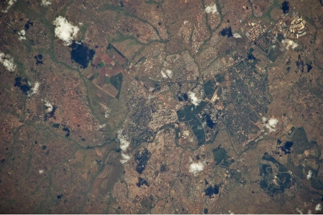
Astronaut photograph of Lilongwe (May 7, 2010). Source: NASA
Other major cities: Blantyre - 856,000 (2009)
|
Administrative Divisions: 28 districts; Central Region:
|
Source: Wikimedia Commons |

Independence Date: 6 July 1964 (from UK)
Legal System: based on English common law and customary law; judicial review of legislative acts in the Supreme Court of Appeal; accepts compulsory ICJ jurisdiction with reservations
The constitution provides for an independent judiciary. Malawi's judicial system, based on the English model, is made up of magisterial lower courts, a high court, a Supreme Court of Appeal, and a constitutional court. Local government is carried out in 28 districts within three regions administered by regional administrators and district commissioners who are appointed by the central government. Constitutionally mandated local elections are to be held 1 year after presidential and parliamentary elections. The first local elections in the multiparty era took place in on November 21, 2000, and the UDF party won 70% of the seats. The second round of local elections, originally scheduled for May 2005, were never held. Local elections were again scheduled for May 2010, but these elections have been indefinitely postponed as well.
Suffrage: 18 years of age; universal
International Environmental Agreements
Malawi is party to international agreements on: Biodiversity, Climate Change, Climate Change-Kyoto Protocol, Desertification, Endangered Species, Environmental Modification, Hazardous Wastes, Marine Life Conservation, Ozone Layer Protection, Ship Pollution, and Wetlands. It has signed, but not ratified the international agreement known as the Law of the Sea.
Foreign Relations
Malawi has continued the pro-Western foreign policy established by former President Hastings Banda. It maintains good diplomatic relations with principal Western countries. Malawi's close relations with South Africa throughout the apartheid era strained its relations with other African nations. Following the collapse of apartheid in 1994, Malawi developed, and currently maintains, diplomatic relations with all African countries.
Between 1985 and 1995, Malawi accommodated more than a million refugees from Mozambique. The refugee crisis placed a substantial strain on Malawi's economy but also drew significant inflows of international assistance. The accommodation and eventual repatriation of the Mozambicans is considered a major success by international organizations. In 1996, Malawi received a number of Rwandan and Congolese refugees seeking asylum. The government did not turn away refugees, but it did invoke the principle of "first country of asylum." Under this principle, refugees who requested asylum in another country first, or who had the opportunity to do so, would not subsequently be granted asylum in Malawi. There were no reports of the forcible repatriation of refugees.
Recently Malawi’s relationship with Mozambique has become strained. An impasse in 2010 over the use of the Zambezi River for waterborne trade and a stalled electrical grid interconnector agreement highlight the challenges inherent to this important relationship. Use of the rail line to Nacala in eastern Mozambique is limited by the poor condition of the track, old and inadequate rolling stock and engines, and inferior port facilities at Nacala. There has been a recent resurgence of interest in the development of the Nacala corridor. The Brazilian company Vale has invested in efforts to export coal from the Moatize/Tete region in western Mozambique through Malawi to Nacala. The Nacala corridor project involves mutual benefits to Mozambique and Malawi, and it could improve the strained relationship between the two countries and contribute to stronger regional economic integration.
Important bilateral donors, in addition to the U.S., include Canada, Germany, Iceland, Ireland, Japan, the Netherlands, Norway, Sweden, and the United Kingdom. Multilateral donors include the World Bank, the IMF, the European Union, the African Development Bank, and United Nations organizations.
Malawi continues to work to strengthen its relationships with other nations that are not historical bilateral donors. These nations include Cuba, India, Iran, and the People’s Republic of China. Efforts at building these relationships have included high-level visits and the exchange of ambassadors.
Malawi is a member of the following international organizations: UN and some of its specialized and related agencies (i.e., UNCTAD, UNESCO, UNIDO), IMF, World Bank, Multilateral Investment Guarantee Agency (MIGA), World Intellectual Property Organization (WIPO), Berne Convention, Universal Copyright Convention, African Union, Cotonou Agreement, African Development Bank (AFDB), Southern African Development Community (SADC), the Common Market for East and Southern Africa (COMESA), Nonaligned Movement, G-77, and the World Health Organization (WHO).
International Disputes: disputes with Tanzania over the boundary in Lake Nyasa (Lake Malawi) and the meandering Songwe River remain dormant
Water
Total Renewable Water Resources: 17.3 cu km (2001)
Freshwater Withdrawal: Total: 1.01 cu km/yr (15% domestic, 5% industrial, 80% agricultural).
Per capita Freshwater Withdrawal:: 78 cu m/yr (2000)
Access to improved sources of drinking water: 80% of population
Access to improved sanitation facilities: 56% of population
Agriculture
Malawi's economy is heavily dependent on agriculture, with tobacco, tea, and sugar as its most important export crops. Traditionally, Malawi has been self-sufficient in its staple food, maize (corn), and during the 1980s exported substantial quantities to its drought-stricken neighbors. Agriculture represents 31% of GDP and represents about 80% of all exports. Nearly 90% of the population engages in subsistence farming. Smallholder farmers produce a variety of crops, including maize, beans, rice, cassava, tobacco, and groundnuts (peanuts). The agricultural sector contributes approximately 64% to the total income for the rural population, 65% of manufacturing sector's raw materials, and approximately 87% of total employment.
Agricultural Products: tobacco, sugarcane, cotton, tea, corn, potatoes, cassava (tapioca), sorghum, pulses, groundnuts, Macadamia nuts; cattle, goats
Irrigated Land: 560 sq km (2003)
Resources
Natural Resources: limestone, arable land, hydropower, unexploited deposits of uranium, coal, and bauxite.
Energy
Energy is a major constraint to economic development in Malawi. With an installed capacity of only 286 MW and an electrification rate of approximately 9% (about 1% to 3% in rural areas), Malawi’s power sector falls behind most of its peers in sub-Saharan Africa. In April 2011, the MCC and Malawi signed a $350.7 million Compact focused on revamping Malawi’s inadequate and unreliable electrical power sector. The project would implement power sector reform and improvement, including electrical grid infrastructure development with a focus on promoting private sector investment in new power generation. The MCC estimates that the Compact Program would result in $3.1 billion in income benefit to Malawi over the next 25 years. MCC further estimates that 5.9 million Malawians would benefit from increased employment income and business profit during this period. In July 2011, the MCC placed an operational hold on the Compact due to concerns over negative trends in political and economic governance following violent demonstrations throughout Malawi on July 20 and 21.
| Energy in Malawi- | |||||
| Production | Consumption | Exports | Imports | Reserves | |
| Electricity | 1.676 billion kWh (2008 est.) |
1.559 billion kWh (2008 est.) |
0 kWh (2010) |
0 kWh (2010) |
|
| Oil | 0 bbl/day (2009 est.) |
8,000 bbl/day (2010 est.) |
0 bbl/day (2009) |
7,124 bbl/day (2009 est.) |
0 bbl |
| Natural Gas | 0 cu m (2009 est.) |
0 cu m (2009 est.) |
0 cu m (2009 est.) |
0 cu m |
0 cu m (1 January 2011 est.) |
| Source: CIA Factbook | |||||
Economy
Landlocked Malawi ranks among the world's most densely populated and least developed countries.
Its economy is heavily dependent on agriculture, with tobacco, tea, and sugar as its most important export crops. Traditionally, Malawi has been self-sufficient in its staple food, maize (corn), and during the 1980s exported substantial quantities to its drought-stricken neighbors. Agriculture represents 31% of GDP and represents about 80% of all exports. Nearly 90% of the population engages in subsistence farming. Smallholder farmers produce a variety of crops, including maize, beans, rice, cassava, tobacco, and groundnuts (peanuts). The agricultural sector contributes approximately 64% to the total income for the rural population, 65% of manufacturing sector's raw materials, and approximately 87% of total employment. Financial wealth is generally concentrated in the hands of a small elite. Malawi's manufacturing industries are situated around the city of Blantyre. Recent years have seen increased activity in Malawi’s historically undeveloped minerals sector. A major uranium mine that opened in 2009 in the north of the country is contributing significantly to export earnings and overall GDP. A full bankable feasibility study began in late 2009 on what is projected to be a similarly significant niobium deposit in central Malawi.
Malawi's economic reliance on the export of agricultural commodities leaves it vulnerable to external shocks such as declining terms of trade and drought. Labor costs are low, but high transport costs, which can amount to 50% of the price of imports and exports, constitute an impediment to economic development and trade. A shortage of skilled labor; bureaucratic red tape; corruption; and inadequate and deteriorating transportation, electricity, water, and telecommunications infrastructure further hinder economic development in Malawi. However, recent government initiatives targeting improvements in the road infrastructure, together with private sector participation in telecommunications, have improved basic infrastructure.
Malawi has undertaken economic structural adjustment programs supported by the World Bank, the International Monetary Fund (IMF), and other donors since 1981. Broad reform objectives include stimulation of private sector activity and participation through the elimination of price controls and industrial licensing, liberalization of trade and foreign exchange, rationalization of taxes, privatization of state-owned enterprises, and civil service reform. In August 2005 the IMF approved a Poverty Reduction and Growth Facility (PRGF) for Malawi. In August 2006 Malawi successfully reached the completion point under the Heavily Indebted Poor Countries (HIPC) Initiative, resulting in debt relief from multilateral and Paris Club creditors. Over $2 billion in debt has since been canceled, enabling the government to increase expenditures for development.
Economic growth had been brisk, with real GDP rising by 7.6% in 2009 and 7.1% in 2010. Real GDP growth for 2011 was 4.6% (CIA World Factbook). The Economist Intelligence Unit (EIU) continues to downgrade forecasts of real GDP growth, from 5.3% for 2011 to 4.3% for 2012. Inflation has been largely under control since 2003, averaging 10% in that year and 7.4% in 2010. Discount and commercial lending rates have declined from 40%-45% in 2003 to 25.3% currently.
After holding the Kwacha’s rate against the dollar fixed for 5 years, since late 2009 the government has allowed some adjustment to the exchange rate. In December 2010 the Kwacha had depreciated to 150.8 to the U.S. dollar. In August 2011 the Kwacha depreciated to 165 to the U.S. dollar. The government is expected to allow further controlled depreciation in 2012. Fiscal management under the Mutharika administration kept the macroeconomic environment relatively stable over the past 5 years. However, the lack of a competitive real exchange rate and resulting imbalances recently have caused a pronounced and chronic foreign exchange shortfall, leading to supply shortages of most imported goods (fuel, construction materials, and other raw materials not available in Malawi). The Kwacha is still generally considered to be overvalued, and with imports still heavily outweighing exports the country continues to suffer from a severe shortage of foreign exchange.
Malawi has bilateral trade agreements with its two major trading partners, South Africa and Zimbabwe, both of which allow duty-free entry of Malawian products into their countries. Malawi is a member of two regional trade organizations, the Common Market for Eastern and Southern Africa (COMESA), and the Southern African Development Community (SADC)
The government faces many challenges including developing a market economy, improving educational facilities, facing up to environmental problems, dealing with the rapidly growing problem of HIV/AIDS, and satisfying foreign donors that fiscal discipline is being tightened.
Donors, who provided an average of 36% of government revenue in the past five year, suspended general budget support for Malawi in 2011 due to a negative IMF review and governance issues.
GDP (Purchasing Power Parity): $13.77 billion (2011 est.)
GDP (Official Exchange Rate): $5.7 billion (2011 est.)
GDP- per capita (PPP): $900 (2011 est.)
GDP- composition by sector:
agriculture: 30.3%
industry: 16.3%
services: 53.4% (2011 est.)
Population Below Poverty Line: 53% (2004)
Industries: tobacco, tea, sugar, sawmill products, cement, consumer goods
Exports: tobacco 53%, tea, sugar, cotton, coffee, peanuts, wood products, apparel
Export Partners: South Africa 12.4%, Germany 12%, Egypt 9.4%, Zimbabwe 8.3%, US 7.5%, Russia 4.7%, Netherlands 4.5% (2006)
Imports: food, petroleum products, semimanufactures, consumer goods, transportation equipment
Import Partners: South Africa 34.9%, India 8.2%, Zambia 7.8%, Tanzania 5.9%, US 5.9%, China 4.3% (2006)
Economic Aid Recipient: $575.3 million (2005)
Currency: Malawian kwacha (MWK)
Ports and Terminals: Chipoka, Monkey Bay, Nkhata Bay, Nkhotakota, Chilumba.