Main River, Canada
| Topics: |
General Description
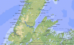
 Map of the Main River. (Source: Biodiversity Institute of Ontario)
 The Main River is one of the last true wilderness rivers left on the "Rock" – the island of Newfoundland. It is a short, fast-moving river found in the relatively inaccessible Great Northern Peninsula. The Main stretches 57 kilometers (km) from its headwaters in the Long Range Mountains to its mouth at White Bay in the Atlantic Ocean. It drains an area of over 1000 sq. km and has an average discharge of more than one cubic km per year.
River Course
The Main River flows southeast from tundra-like barrens, through expanses of softwood forests and unique grassland areas as well as a spectacular 8 km canyon. It starts at an elevation of 370 m and travels a relatively steep gradient (averaging 6.5m/km) as it descends from the mountains. The river is joined by many tributaries in the upper reaches and gradually increases in volume and steepness as it moves downstream. Its character continuously changes as narrow, swift channels alternate with long steady reaches. The abrupt and significant variations in gradient, channel width and direction result in numerous turbulent rapids. Five distinct sections have been distinguished along the Main: Four Ponds Lake, Upper River, Big Steady, Rapid River and Deep Valley. The community of Sops Arm is located near the river mouth.
Heritage
In 1991, the Main became the first river nominated by Newfoundland and Labrador for designation as a Canadian Heritage River. Its outstanding natural values and recreation potential have earned it this distinction. Its relative inaccessibility has protected it from encroachment of industrial and urban development, and most of the watershed is now owned and protected by the Government. The watershed contains a diversity of wilderness comparable to much larger rivers in other regions of Canada. It provides critical habitat for a variety of wildlife, including moose, caribou and black bear, many species of birds, and one of the healthiest populations of Atlantic salmon in the province.