Lower Mississippi Riverine Forest Province
Contents
Lower Mississippi Riverine Forest Province (Bailey)
Lower Mississippi River floodplain, 44,300 mi2 (114,700 km2)
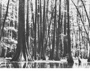 Virgin bald cypress growing in grassy lake in Arkansas.
 Land-surface form
The province consists of flat to gently sloping broad floodplain and low terraces made up of alluvium and loess. From near sea level in the south, altitude increases gradually to about 660 ft (200 m) in the north. Most of the area is flat, with an average southward slope of less than 8 in/mi (127 mm/km). The only noticeable slopes are sharp terrace scarps and natural levees that rise sharply to several meters above adjacent bottom lands or stream channels. This is the land of oxbow lakes--the cutoff meanders. Swamps are significant in the extreme southern part of Louisiana.
Climate
The climate is similar to that found in adjoining parts of the Subtropical Division. Winters are warm, with temperatures ranging from 50 to 60F (10 to 16C), and summers are hot, with temperatures ranging from 70 to 80F (21 to 27C). Rain falls throughout the year, with a minimum in autumn. Temperature and precipitation decrease as one moves northward. At Natchez, Mississippi, average temperatures for January and August are about 50F (10C) and 75F (24C), respectively. Average annual precipitation is 55 in (1,400 mm). Snowfall is negligible. Farther north, at Cairo, Illinois, average temperatures for January and August are about 41F (5C) and 77F (25C), respectively. Average annual precipitation is 43 in (1,100 mm).
Vegetation
Before cultivation, this area was covered by bottom:land deciduous forest with an abundance of green and Carolina ash, elm, cottonwood, sugarberry, sweetgum, and water tupelo, as well as oak and bald cypress. Pecan is also present, associated with eastern sycamore, American elm, and roughleaf dogwood. Vines are prolific along water courses.
Soils
The soils are a mosaic of Inceptisols (in alluvial bottom land), Alfisols (in areas of loess), and Mollisols (in areas with swampy vegetation).
Fauna
Among the numerous bird species found here are the prothonotary warbler, white-eyed vireo, wood duck, yellow-billed cuckoo, Louisiana waterthrush, and all the species found in the Southeastern Mixed Forest.
Return to Ecoregions of the United States
| Disclaimer: This article is taken wholly from, or contains information that was originally published by, the United States Forest Service. Topic editors and authors for the Encyclopedia of Earth may have edited its content or added new information. The use of information from the United States Forest Service should not be construed as support for or endorsement by that organization for any new information added by EoE personnel, or for any editing of the original content. |