Lower Gangetic Plains moist deciduous forests
Lower Gangetic Plains moist deciduous forests.
The Lower Gangetic Plains Moist Deciduous Forests lie along the confluence of two of Asia's largest rivers, the Ganges and Brahmaputra rivers, which run the length of the Himalayan foothills and drain its breadth. It once harbored impressive populations of tiger (Panthera tigris), greater one-horned rhinoceros (Rhinoceros unicornis), Asian elephant (Elephas maximus), gaur (Bos gaurus), swamp deer (Cervus duvaucelli), and Bengal florican (Eupodotis bengalensis). Today, the ecoregion supports one of the densest human populations on Earth, and the fertile alluvial plains have been cleared and intensely cultivated. The human activities that date back thousands of years have taken a very heavy toll on the natural biodiversity of the ecoregion, and many of these species have disappeared from the ecoregion.
Location and General Description
The tropical moist deciduous forests represented by this ecoregion once stretched along the lower reaches of the Ganges and Brahmaputra river plains across the Indian states of Bihar, West Bengal, Assam, Upper Pradesh, and Orissa and most of Bangladesh. The southwest monsoon that sweeps in from the Bay of Bengal deluges the ecoregion with more than 3,500 millimeters (mm) of rainfall during the four months from June to September. Devastating cyclones sweep in from the Bay of Bengal, causing widespread flooding.
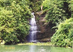 Karnafuli Reservoi (Kaptai Lake), Bangladesh. (Source: Photograph by Galen R. Frysinger) The alluvial substrate deposited by the rivers is clayey and drains poorly, but on the more stable but flood-prone riverine flats the soil tends to be more sandy, with only local clay patches.
The vegetation is semi-deciduous; the upper canopy contains the deciduous species, and the second story is dominated by evergreen species. Open forests are dominated by Bombax ceiba in association with Albizzia procera, Duabanga sonneratioides, and Sterculia vilosa. These are early seral communities that will eventually become sal (Shorea robusta) forest if succession is allowed to proceed. But in most places the forests fail to reach a climax stage for various reasons (many human-caused) perpetuating the sub-climax community.
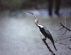 Darter (Anhinga melanogaster), India. (Source: Photograph by Rahula Perera)
 The riparian forests are characterized by an Acacia-Dalbergia association that includes Acacia catechu, Albizzia procera, Bombax ceiba, Sterculia villosa, and Dalbergia sisso. In the upper Assam areas of the ecoregion, the forests are made up of Duabanga-Pterospermum-Terminalia in association with Bombax ceiba, Pterspermum acerifolium, Laportea crenulata, Duabanga sonneratioides, Terminalia myriocarpa, and Calamus tenuis.
In permanently wet or moist areas with fine, [[clay]ey] [[soil]s] and a rich humus layer, impenetrable canebrakes grow profusely in the understory. Annual fires are common, so fire-hardy species such as Zizyphus mauritiana, Madhuca latifolia, Aegle marmelos, Butea monosperma, Terminalia tomentosa, Ochna pumila, and several others also occur in these fire-prone areas.
Biodiversity Features
 Karnafuli Reservoi (Kaptai Lake), Bangladesh. (Source: Photograph by Galen R. Frysinger)
 The ecoregion does not exhibit high levels of endemism but does harbor several threatened species. The mammal fauna consists of 126 known species, including one near-endemic species, a bat, Tadarida teniotis (Table 1). The mammal assemblage also includes several threatened species such as the tiger, Asian elephant, gaur, sloth bear (Melursus ursinus), smooth-coated otter (Lutrogale perspicillata), great Indian civet (Viverra zibetha), and four-horned antelope or chousingha (Tetracerus quadricornis). The ecoregion's large habitat blocks are an important contribution to conservation of the large, wide-ranging mammals on northeastern India and overlaps with three Level I Tiger Conservation Unit (TCUs). The elephant population in Midnapur district is considered to be of high conservation importance.
|
Table 1. Endemic and Near-Endemic Mammal Species. Family Species Molossidae Tadarida teniotis An asterisk signifies that the species' range is limited to this ecoregion. There are more than 380 known bird species, although none are endemic. However, the ecoregion (Lower Gangetic Plains moist deciduous forests) harbors two globally threatened species, the Bengal florican and the lesser florican (Eupodotis indica), as well as the threatened Pallas's fish-eagle (Haliaeetus leucoryphus) and swamp francolin (Francolinus gularis). The Indian grey hornbill (Ocyceros birostris) and Oriental pied-hornbill (Anthracoceros albirostris) are indicators (Indicator species) of intact forests and deserve conservation attention. {| style="width: 500px" width="300" border="1" cellpadding="3" align="right" ! colspan="3" | Table 2. WCMC (1997) Protected Areas That Overlap with the Ecoregion. Protected Area Area (km2) IUCN Category Gautam Budha 140 IV Udaipur 50 IV Kaimur 2,370 IV Chandra Prabha 80 IV Rajgir 290 IV Kaimur 120 IV Valmikinagar 230 IV Raiganj 40 IV Kabartal 30 PRO Ramsagar 10 UA Ganga Dolphin 160 PRO Nakti Dam 200 IV Narendrapur 90 IV Jaldapara 70 IV Chalan Beel WS 170 ? Bil Bhatia WS 30 ? Madhupur 110 V Hail Haor 100 PRO Roa 10 IV Bhawal 90 V Rema-Kalenga 50 IV Gumti 420 IV Sepahijala 20 IV Trishna 270 IV Aila Beel WS 30 VIII Kawadighi WS 10 ? Unnamed 20 ? Dakhar Haor WS 40 ? Dubriar Haor WS 20 ? Erali Beel WS 10 ? Hakaluki Haor WS 160 ? Kawadighi WS 20 ? Kuri Beel WS 30 ? Meda Beel WS 20 ? Rajkandi WS 50 ? Tangua Haor WS 160 ? West Bhanugach WS 50 ? Hazarikhil 30 PRO Rampahar-Sitapahar 10 PRO Chunati 90 IV Chimbuk WS 30 ? Himchari 20 UA Teknaf 100 VIII Sangu Matamuhari 960 ? Total 7,010 Ecoregion numbers of protected areas that overlap with additional ecoregions are listed in brackets. (Lower Gangetic Plains moist deciduous forests) ==Current Status== Despite hundreds of years of human settlement, much forest still remained until the early twentieth century. Since then deforestation has accelerated, and now the ecoregion's natural habitat borders on the verge of extinction. Only about 3 percent of the ecoregion is now under natural forest, and only one large block of intact habitat (south of Varanasi) remains in this ecoregion. Although more than forty protected areas are represented in the ecoregion, they cover only about 3 percent of the ecoregion, and more than half of these protected areas are small, being less than 100 km2 in area (Table 2). ==Types and Severity of Threats== The dense human population is still growing rapidly. The urbanization, industrialization, and agriculture associated with this growing population and its resource and economic needs pose serious threats to the remaining forest fragments. The small, protected areas are vulnerable to this tidal wave of human growth (Population growth rate) and are inadequate to conserve the ecoregion's biodiversity. Finding additional habitat for protection will be challenging. Therefore, the existing protected areas should be effectively managed and protected, and restoring critical habitat should be considered where necessary. ==Justification of Ecoregion Delineation== In previous analyses of conservation units in the region, Rodgers and Panwar and then MacKinnon placed these forests in one conservation unit but also included the freshwater swamp forests and mangroves with the moist deciduous forests. In keeping with our rules for defining ecoregions, we separated the freshwater swamp forests and mangroves into their own ecoregions and defined the moist forests as the Lower Gangetic Plains Moist Deciduous Forests. We used MacKinnon's map of originalvegetation as a guide to delineate the spatial extents of the vegetation types. This ecoregion roughly corresponds to Udvardy's Bengalian rain forest biogeographic province but extends further westward into the Indus-Ganges monsoon forest biogeographic province and further east into the Burma monsoon forest biogeographic province. ==Additional Information on this Ecoregion== * For a shorter summary of this entry, see the WWF WildWorld profile of this ecoregion. * To see the species that live in this ecoregion, including images and threat levels, see the WWF Wildfinder description of this ecoregion. * World Wildlife Fund Homepage |
|---|