Lake Baikal Basin
Contents
- 1 Lake Baikal Basin, Russian Federation
- 1.1 Ecological threats
- 1.2 Geographical location
- 1.3 Date and history of establishment
- 1.4 Area
- 1.5 Land tenure
- 1.6 Altitude
- 1.7 Physical features
- 1.8 Climate
- 1.9 Vegetation
- 1.10 Fauna
- 1.11 Cultural heritage
- 1.12 Local Human Population
- 1.13 Visitors and Visitor Facilities
- 1.14 Scientific Research and Facilities
- 1.15 Conservation Value
- 1.16 Conservation Management
- 1.17 IUCN Management Category
- 1.18 See Also
- 1.19 Further reading
Lake Baikal Basin, Russian Federation
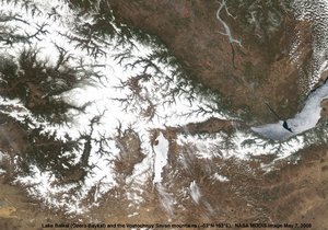
Lake Baikal Basin (53°10'24.96 North, 107°39'45 East) is a World Heritage Site located in the Russian Federation. Situated in south central Siberia close to the Mongolian border, Lake Baikal is the oldest by 25 million years, and deepest, at 1637 metres (m), of the world's lakes. It is 3.15 million hectares (ha) in size and contains a fifth of the world's unfrozen surface freshwater. Its age and isolation and unusually fertile depths have given it the world's richest and most unusual lacustrine fauna which, like the Galapagos Islands, is of outstanding value to evolutionary science. The exceptional variety of endemic animals and plants make the lake one of the most biologically diverse on Earth.
Ecological threats
A pulp and cellulose mill on the southern shore, which has created water pollution of 200 square kilometres (km2) of the lake and generated some of the highest air (Air pollution) pollution in Russia, during periods of prior peak operation. Agricultural and urban waste from the river Selenga and potential oil and gas exploration in the Selenga delta pose additional threats, particularly due to lack of stringent standards and environmental enforcement from the Russian government.
Geographical location
This World Heritage Site is located in south central Siberia, near the Mongolian border, comprising Lake Baikal (53°10'24.96 North, 107°39'45 East) and the land five km to 70 km surrounding it. The nearest cities and airports are Irkutsk 60 km to the west and Ulan Ude to the east, both on the Trans-Siberian railway: 51°27'N - 55°46’ and 103°43' – 109°56’E.
Date and history of establishment
- 1916: Barguzinskiy Zapovednik, the first nature reserve, established on the northeast coast of the Lake;
- 1969: Baikalskiy Zapovednik Nature Reserve established in the south;
- 1974: Kabanskiy Zakaznik Management Area established in the south-east;
- 1976: Frolikhinskiy Zakaznik Management Area established in the north;
- 1986: Baikalo - Lenskiy Nature Reserve in the north-west, Zabaikalskiy National Park in the east and Pribaikalskiy National Park in the south-west were established; Baikalskiy (200,524 ha) and Barguzinskiy (358,600 ha) Zapovedniks designated parts of the Lake Baikal Region Biosphere Reserve;
- 1987: Lake Baikal Coastal Protection Zone established by Decree 434 of the USSR Council of Ministers to protect lakeshore forests: the World Heritage site coincides with this Coastal Protection Zone;
- 1994: The Selenga River delta (Kabanskiy Zakaznik) recognised as a Ramsar site (12,100 ha);
- 1999: Russian federal law for the protection of Lake Baikal passed.
Area
88,000 km2: Lake Baikal, 31,471 km2, Coastal Protection Zone 56,500 km2 (19,490 km2 protected):
- Baikalo-Lenskiy Zapovednik 659,919 ha Baikalskiy Zapovednik 165,724 ha
- Pribaikalskiy National Park 418,000 ha, Frolikhinskiy Zakaznik 68,000 ha
- Barguzinskiy Zapovednik 374,423 ha Kabanskiy Zakaznik 18,000 ha
- Zabaikalskiy National Park 245,000 ha
Land tenure
Government, in the Irkutsk Region and the Buryat Autonomous Republic. Administered by the Russian State Heritage Committee of Environmental Protection and the Federal Forestry Service, coordinated by the Baikal Commission. There are some long-term leases to organizations and private individuals.
Altitude
From 1182 m underwater to 2840 m in the Barguzinskiy mountains. The elevation of Lake Baikal is 455 m.
Physical features
Lake Baikal is the seventh largest by surface area, and the largest by water volume in the world. This lake is the deepest lake in the world and contains over a fifth of the world's unfrozen surface fresh water (23,000 km3). It is 636 km long by 27 to 80 km wide, has 2100 km of coastline and the bottom is 1182 m below sea level. Upwelling currents and vertical water movements oxygenate the water at depth. It is walled in by mountains: the narrow Primorskiy and Baikalskiy ranges to the west, the Barguzinskiy and Ulan-Bagasy ranges on the east and the Khamar Daban mountains in the south. 335 main tributaries flow in from these, the largest [[river]s] being the Selenga, Turka, Barguzin and Upper Angara. Only the Angara, a tributary of the Yenesei, flows out; a dam on this has raised the level of the lake altering its ecology. The lake has exceptionally clear water with up to 40 m visibility, and a mineral content 25-50% lower than most other freshwater (Freshwater biomes) lakes. The unusual purity of the water is due to the presence of zooplankton which consume the debris, and because most of its watershed is rocky and unfarmed so that inflowing waters have relatively low mineral or chemical content.
The lake is of tectonic origin, situated in an active rift complex system of block-faulted depressions and consists of three deep basins resting on 7 km of sediments. It is 25 million years old, the oldest large lake in the world, its formation having taken place during the Palaeozoic, Mesozoic and Cenozoic periods. Hydrothermal vents 400 m deep at Frohlika Bay are evidence of the ongoing tectonic activity of the area.
Climate
The Baikal basin has a continental climate with profound fluctuations of both annual and daily temperatures. Winters are long, dry and cold. Mean daily temperatures range from -25°C in January to +18°C in July. However, Lake Baikal itself creates a distinct microclimate within 25 km of its shores: the water being slow to warm up and slow to cool moderates coastal conditions where temperatures may be 5°C higher in winter and 5°C lower in summer. Annual rainfall at the north end of the lake averages 200-350 millimeters (mm), at the south end, 500-900 mm, falling mainly in summer storms. Fogs occur in spring and autumn. The surface of the lake freezes for four months during winter, with ice until June. The wind regime is coastal: winter winds blow from the cold land to the lake, summer winds, from the lake to the warmer land. Winds from the mountains can be sudden and violent, creating high waves.
Vegetation
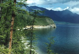
The Baikal region is on the frontier between the east Siberian taiga, to the west and north, the trans-Baikal coniferous forest to the east and the Altai-Sayan montane forest to the south. The great variety of plants in the basin is determined by climatic asymmetry: the southwestern part of the basin is covered by sparse coniferous forests and mountain steppes; in the east Scots pine Pinus sylvestris forest predominates and the north is dominated by deciduous forests. Terraces near the shore in the north are dominated by Dahurian larch Larix gmelina with Rhododendron dahuricum, grading on the eastern and western shores into forests of Siberian cembra or stone pine Pinus sibirica with Siberian larch Larix sibirica. Associated broadleaf species are the willow-like Chosenia arbutifolia, aspen Populus tremula, birches Betula pendula, and B.alba, Siberian rowan Sorbus sibirica, Siberian almond Amygdalys pedunculata, bird cherry Prunus asiatica, Siberian apricot P.sibirica with an understorey of honeysuckle Lonicera periclymenum and currants Ribes rubrum, R. nigrum. At higher altitudes are pure stands of fir Abies sibirica and Pinus sibirica forest with Korean pine Pinus koraiensis (R) and black spruce Picea obovata, followed still higher up by thickets of dwarf pine Pinus pumila. The highest level is tundra dominated by cyperus Kobresia sibirica and peaty meadows of sedge Carex spp. with stone birch Betula ermanii on stony talus, and lichen Cladonia- or Cetraria-covered rocks and cliffs. 600 species of vascular plants have been recorded including 20 species of flowering plants.
In the southern part of the basin, a well-marked altitudinal zonation also occurs. Sphagnum bogs and forests of poplar Populus suavolens and the monotypic willow Chosenia arbutifolia occupy low-lying areas, with a relict species, the Siberian apple Malus pallasiana, while river valleys contain bird cherry Prunus padus, rowan S. sibirica and alder Alnus fruticosa. The northern slopes of the mountains have taiga of Korean pine P. koraiensis, black spruce Picea obovata and Pinus sibirica, with Siberian fir Abies sibirica dominant in places. The southern slopes are covered in mixed larch L. sibirica and pine P. sylvestris forest which gives way to steppe vegetation on the foothills. At higher altitudes there is Pinus sibirica elfin woodland and mountain tundra shrubs such as Rhododendron parvifolium. The high altitude meadows support thickets of dwarf Siberian pine P. pumila and birch Betula middendorfii. Some 1000 species of aquatic flora are said to exist, 15% of them endemic. The vegetation of the Selenga delta is of reedbeds, regularly flooded sedge meadows and shrub willow.
Fauna
About 1,200 species live in the lake, approximately 60 percent of them endemic, which have evolved in isolation from ancient species, and there are twice that number of species in the surrounding taiga. The aquatic fauna of Lake Baikal is one of the most diverse and unusual in the world, including sponge reefs, 255 species of shrimp-like amphipods, 147 species of snail and 80 species of flatworm. Dense clouds of millions of the tiny crustacean Epischura baicalensis which forms 96 percent of the zooplankton, filter the water of detritus. The deep hydrothermal vents of [[oxygenate]d] water also attract an unusual range of species including sponges. The most noteworthy aquatic species is the unique nerpa, the endemic freshwater Baikal seal Phoca sibirica.
Winter surface ice has extremophile micro-organisms embedded.
The terrestrial fauna is less distinctive. The northern lake [[shore]s], as in Barguzinskiy Zapovednik, has a faunal diversity characteristic of the taiga, with 39 recorded species of mammal recorded, including pika Ochotona hyperborea, Siberian chipmunk Eutamias sibiricus, marmot Marmota baibacina, Siberian flying squirrel Pteromys volans, fox Vulpes vulpes, brown bear Ursus arctos, ermine Mustela erminea, and mountain, common and Kolinsky weasels Mustela altaia, M. nivalis and M. sibirica, otter Lutra lutra, large numbers of sable Martes zibellina princeps, noted for its exceptionally valuable fur, wolverine Gulo gulo, a local race of musk deer Moschus moschiferus, Siberian red deer Cervus elaphus sibiricus, elk Alces alces and reindeer Rangifer tarandus. The avifauna includes 261 bird species, among them the Siberian crane Grus leucogeranus (EN), swan goose Anser cygnoides (VU), imperial eagle Aquila heliaca (VU), Asian dowitcher Limnodromus semipalmatus (VU), corncrake Crex crex (VU), white-tailed eagle Haliaeetus albicilla and capercaillie Tetrao urogallus. Numbers of breeding Anatidae can reach 138,000. On migration, 5-7 million waders and waterbirds pass through the Selenga delta. The clouds of summer insects are as nourishing as the invertebrate life of the water.
To the south, in the Baikalskiy Zapovednik, there are 37 mammal species and 260 species of birds. Many of them are the same species found in the northern part of the basin but also include steppe polecat Mustela eversmanii and Kolinsky weasel M. sibirica, lynx Felis lynx, wild pig Sus scrofa and roe deer Caprolus capreolus. Birds include species of swan goose Anser cygnoides, crested honey buzzard Pernis ptilorhyncus, black kite Milvus migrans, hawk owl Sunia ulula, rock ptarmigan Lagopus mutus, hazel grouse Tetrastes bonasia, capercaillie Tetrao urogallus and great bustard Otis tarda. There are 53 species of fish, most of them edible. 27 are endemic, including Baikal sturgeon Acipencer schrenskii and A.baeri baicalensis, the omul salmon Coregonus autumnalis migratorius, Baikal black grayling Thymallus arcticus baicalensis, 32 species of bullhead Ictalurus spp. and the viviparous large and small oilfish golumyanka and gobi, Comephoridae baicalensis and C. dubowski.
Cultural heritage
The region has a rich heritage of Mongolian culture. Some 1200 archaeological remains of past cultures have been found around the lake shores: 1000 such monuments have legal protection: rock drawings, stone walls and the ruins of ancient settlements. Lake Baikal and the Selenga River are mentioned in ancient Chinese chronicles, Muslim historical manuscripts and old Russian books. The Huns, Kaganates of the Zhouzhanhs, ancient Turks, Uighurs and Kidanhs, who maintained broad international relations with both the East and the West lived around the Lake. The 13th century Mongolian leader Genghis Khan is popularly supposed to have been born on Ol’khan island where there is a revered shamanic shrine. Buddhist and Russian Orthodox churches also co-exist in the region.
Local Human Population
The local population is composed of several ethnic groups: Buryats, the largest indigenous race in Siberia, Evenks and Russians who first colonized the region in the mid 18th century. The population living permanently in the Lake Baikal basin is about one hundred thousand people. About half of the population is urban, the remainder live in villages. The main occupations are forestry, agriculture, fisheries (Fisheries and aquaculture), hunting and tourism. The chief towns in the area are Severobaikalsk, Selenginsk, Babushkin, Baikalsk and Sludyanka. The territories of these five towns are excluded from the World Heritage property.
Visitors and Visitor Facilities
Lake Baikal is much visited by local, national and international tourists. There are several camping and tourist bases on the lake shore. The more inhabited southern and eastern parts have better developed facilities and infrastructure. The Khamar Daban ranges of the eastern Sayans and Barguzin mountains attract climbers. Irkutsk and Ulan Ude provide services and facilities for tourists and visitors.
Scientific Research and Facilities
Owing to its age, isolation and the diversity of its deep water life, the lake is a natural laboratory, like the Galapagos islands. The Limnological Scientific Institute of the Russian Academy of Sciences originally based near Listvyanka in 1916 is the major research body. It is well equipped and maintains relations with many other national and international scientific centers. There is also the Baikal station of the Biological Research Institute of Irkutsk State University. An exceptional volume of research has been undertaken on the lake, and the Limnological Institute records more than 10,000 scientific papers.
Conservation Value
The Lake Baikal Basin is an outstanding example of the evolutionary development of a rift zone of global scale. It includes contrasting landscapes of mountains, forests, steppes, tundra and lake. It contains the oldest and largest reservoir of freshwater on earth, 60% of the aquatic fauna of which is endemic. The surrounding area is also rich in biological diversity, landscape values and cultural and scientific values.
Conservation Management

Existing protected areas preserve the most important terrain. All zapovedniks (strict nature reserves) in the area are managed by the Russian State Committee of Environmental Protection, all national parks and zakazniks (habitat reserves) are managed by the Federal Forestry service. No information is available about the management plans of the protected areas.
In 1989 the Territorial Comprehensive Scheme for the Protection of Nature in the Area of Lake Baikal was adopted. It is dedicated primarily to the protection of Lake Baikal by creating a central protection zone around the lake and buffer zones in the watershed basin, by control of waste disposal, industry and a complete ban on logging in the sub-coastal zone. A Baikal Commission was established in 1993 and is the key administrative body co-ordinating the efforts of the federal and three regional governments as well as nongovernmental organizations (NGOs) and scientific experts. In 1994 resolution #1306 of the Government of the Russian Federation created the Comprehensive Federal Programme for the Protection of Lake Baikal and Rational Use of its Natural Resources. This was prepared by the Ministry of Environmental Protection and Natural Resources of the Russian Federation in Moscow, the Council of Ministers of the Buryat Republic in Ulan Ude, and the administrations of the Irkutsk and Chita regions. It contains measures to implement an environmental protection strategy in the context of sustainable development. The legal basis for management is provided in a Federal Law on the Protection of Lake Baikal passed in 1999, but this has not yet been implemented. There are also many local laws and regulations to protect the lake. However, an integrated management and comprehensive monitoring plan for the region based on the definition of ecological zones is still needed, as is the basis for adequate implementation of any such plan.
Management constraints
The main source of both air (Air pollution) and water pollution in the Lake Baikal basin is the pulp and cellulose mill at Baikalskiy on the southern shore, which employs 3500 people and has operated since 1957. It pollutes 200 km2 of the lake with dioxin among other poisons and causes some of the worst air pollution in Russia. It has been due for conversion to other uses for several years but for lack of funds and lack of consensus on the seriousness of its impacts, progress is slow: to many, its curtailment is seen as a threat to the economy of the region. A second paper and pulp production complex at Selenginsk has been converted to a closed water-cycle system, and waste dumping into the lake has ceased.
The second major source of pollution is the Selenga river which drains Ulan Ude and several cities in Russia and Mongolia, despite the installation of more than 100 wastewater treatment plants during the past decade. Recently, exploration of the Selenga delta for oil and gas and a pipeline from there to China have been proposed. Coal-fired plants in the southern city of Slyudyanka and industry in the northern city of Severobaikalsk continue to pollute the lake as do 16 surrounding towns and more than 50 industrial enterprises along its shores. 150 km of the south shore is polluted and Irkutsk hydropower dam increases the level of the lake, threatening the ecology of the Selenga delta. Logging in the Coastal Zone ceased in 1986, as did the harmful practice of log transport on the Lake. A third potential threat is the granting of extraction rights to oil and gas in the Selanga delta, and the planned construction of a gas and oil pipeline from there to China. There are minor threats from poaching, overfishing and damage from tourism. However, there is still heavy exploitation in the region outside the core zone including hunting, habitat destruction and soil contamination.
Staff
The Selenga delta Ramsar site has 6 rangers and a hunting manager. The Pribaikalskiy National Park has a Director, Chief Ranger and about 200 employees in 10 ranger districts. No information is available on the staffing of other reserves.
Budget
The national parks gain some revenue from tourism and recreation. In 2001 more than 90million roubles (US$ 3million) was granted by the government for protection of the lake through enforcement of the federal law.
IUCN Management Category
- Biosphere Reserve (part). Ramsar site (part)
- Baikalo-Lenskiy Zapovednik Ia Strict Nature Reserve
- Baikalskiy Zapovednik Ia Strict Nature Reserve. Biosphere Reserve
- Barguzinskiy Zapovednik Ia Strict Nature Reserve. Biosphere Reserve
- Zabaikalskiy National Park II National Park
- Pribaikalskiy National Park II National Park
- Frolikhinskiy Zakaznik IV Habitat/Species Management Area
- Kabanskiy Zakaznik IV Habitat/Species Management Area/ Ramsar Site.
- Natural World Heritage Site, inscribed 1996. Natural Criteria: i, ii, iii, iv
See Also
Further reading
- Birnbaum, H. (1998). Pribaikalsky National Park. University of Washington REECA Studies Center, Seattle, USA.
- Borodin, A. & Syroechkovski, E. (1983). Zapovedniki SSSR. Lesnaya Promyshlennost Publishing House, Moscow. 249 pp.
- Galaziy, G. (1988). Baikal v Voprosakh i Otvetakh. Mysyl Publishing House, Moscow. 286 pp.
- Galaziy, G. et.al. (1993). The Baikal Atlas. Federal Service of Geodesy & Cartography, Moscow. 160 pp.
- Global Nature Fund website, (2002).
- Irkutsk State University (2000). Lake Baikal Homepage.
- Government Committee on Lake Baikal, Russian Federation (1993). The Problems of Lake Baikal Protection and Nature Management in the Lake Baikal. Annual Report. (Unpublished).
- Ministry of Environmental Protection and Natural Resources (1994a). Zapovedniki Rossii: Sbornik Materialov Letopisei Prirody za 1991/92 Gody. Moscow. 210pp.
- Ministry of Environmental Protection and Natural Resources (1994b). Comprehensive Federal Programme for the Protection of Lake Baikal and Rational Use of its Natural Resources. In two parts. Official document approved by Resolution #1306 of the Government of the Russian Federation. (Unpublished).
- Ministry of Environmental Protection and Natural Resources (1995). The Lake Baikal Basin World Heritage Nomination. Moscow. 9 pp.
- Ramsar (1997). A Directory of Wetlands of International Importance: Russian Federation.
- UNESCO World Heritage Bureau (2002). Report on the 26th Session of the World Heritage Committee, Paris.
| Disclaimer: This article contains some information that was originally published by the United Nations Environment Programme-World Conservation Monitoring Centre (UNEP-WCMC). Topic editors and authors for the Encyclopedia of Earth have edited its content and added new information. The use of information from the United Nations Environment Programme-World Conservation Monitoring Centre (UNEP-WCMC) should not be construed as support for or endorsement by that organization for any new information added by EoE personnel, or for any editing of the original content. |