Khathiar-Gir dry deciduous forests
Introduction The Kathiarbar-Gir Dry Deciduous Forests support the only population (Khathiar-Gir dry deciduous forests) of the Asiatic lion (Panthera leo), which is now limited to the small Gir National Park in northwestern India. One of the world's oldest mountain ranges, the Aravalli Hill Range, dating back to the Precambrian, runs through this ecoregion, rising to 1,721 meters (m) at its highest point, Mt. Abu. This region is also the meeting point of the Afrotropical and South Indian floras.
Location and General Description
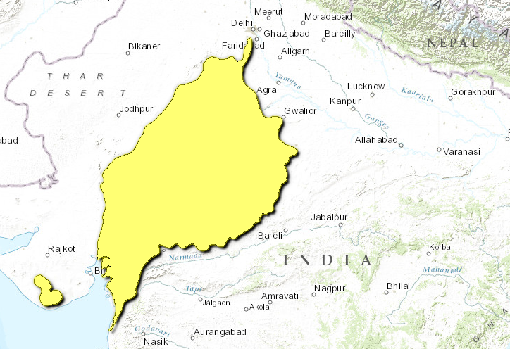
This large ecoregion extends across the India's northwestern states of Gujarat, Rajasthan, and Madhya Pradesh. A small, disjunct portion of this ecoregion is completely included within the Northwestern Thorn Scrub Forestsand represents the Gir forests.
The region is arid for more than eight months of the year. Annual rainfall ranges from about 550 to 700 millimeters (mm), and ambient temperatures regularly exceed 400Celsius.
The dry deciduous forests of this ecoregion are composed of three stories, with the upper canopy reaching from 15 to 25 meters. Even within this dry area, relative differences in moisture levels determine forest composition. Teak (Tectona grandis) forests grow in areas that are less dry, in association with Aegle marmelos, Boswellia serrata, Ougeinia oojeinensis, Diospyros spp., Bombax ceiba, Sterculia urens, Emblica officinalis, Dalbergia paniculata, and Terminalia tomentosa. But in drier areas, the teak-dominated forests are replaced by almost pure stands of Anogeissus pendula that grow predominantly on the quartzite ridges and gneiss hillocks of the Aravalli system, in association with Acacia catechu. The rocky hillocks are characterized by Euphorbia caducifolia, Maytenus emarginata, Acacia senegal, Commiphora mukul, Wrightia tinctoria, Securinega leucopyrus, Grewia tenax, and Grewia villosa.
Mt. Abu is covered with tropical dry deciduous forests, and thorn scrub dominates the rest of the Aravalli Hills in southeast Rajasthan. Most of the [[ecoregion]'s] endemic flora occurs in these hills and includes Dicliptera abuensis, Strobilanthes halbergii, and Veronica anagallis.
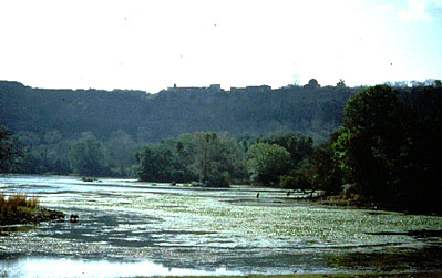
The riparian habitats have a distinctive flora characterized by Phoenix sylvestris and Ficus racemosa.
Biodiversity Features
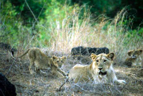
 Asiatic lions (Panthera leo persica), India Photograph by © Persica/Abi Tamim
Although most of the original natural habitat has been degraded or converted, the protected habitats harbor high densities of ungulates that in turn support the large carnivore assemblage, which includes the Asiatic lion, leopard (Panthera pardus), wolf (Canis lupus), and hyena (Hyena hyena).
There are eighty known mammal species in this ecoregion. The only population of the Asiatic lion is now limited to the Gir National Park. In addition to these lions, several other threatened mammal species deserve conservation attention, namely the threatened chousingha (Tetracerus quadricornis), blackbuck (Antilope cervicapra), and chinkara (Gazella bennettii).
The bird fauna approaches 300 species, a high number for these dry forests. These include the white-naped tit, a near-endemic species (Table 1) that prefers thorn scrub habitat, shared with the adjacent Northwestern Thorn Scrub Forests.
|
Table 1. Endemic and Near-Endemic Bird Species. Family Common Name Species Paridae White-naped tit Parus nuchalis The ecoregion (Khathiar-Gir dry deciduous forests) also harbors two globally threatened bird species, the Indian bustard (Ardeotis nigriceps) and lesser florican (Eupodotis indica), which should be focal species for conservation management. ==Current Status== The ecoregion is highly deforested and degraded; however, a few large blocks of habitat still remain and are worth conserving for possible translocations of the Asiatic lion to establish additional populations. Currently, the twenty-one protected areas (average size 427 kilometers2), cover a little over 8,900 kilometers2, or 3 percent, of the ecoregion. Of these, Gir National Park is the largest and most probably the best known because of its lion population. Three other reserves, Balaram-Ambaji, Sariska, and Gandhi Sagar, are more than 900 kilometers2, and three others exceed 500 kilometers2 (Table 2). {| width="408" border="1" cellpadding="3" align="right" ! colspan="3" align="center" | Table 2. WCMC (1997) Protected Areas That Overlap with the Ecoregion. Protected Area Area (km2) IUCN Category Gir 1,720 IV Mt. Abu 490 IV Balaram-Ambaji 980 IV Sariska 980 IV Nahargarh 120 IV National Chambal 30 PRO Ranthambore 550 II Ghatigaon Great Indian Bustard 520 IV Palpur 330 IV Ramgarh 330 PRO Madhav 170 II Madhav extension 170 PRO Jawahar Sagar 130 IV Darrah 150 IV Gandhi Sagar 900 IV Kumbhalgarh 290 IV Jaisamand 40 IV Sita Mata 600 IV Sailana 10 IV Ratanmahal 300 IV Jambughoda 170 IV Total 8,980 (Khathiar-Gir dry deciduous forests) ==Types and Severity of Threats== The numerous threats to the habitat and biodiversity in the ecoregion stem from the resource needs of a fast-growing human population. The most severe threats include livestock grazing, burning, and woodcutting by the indigenous people. However, large-scale mining for marble and minerals have begun to degrade the habitat further. Powerful industrialists with mining interests have lobbied for denotification of protected areas so they can be mined. ==Justification of Ecoregion Delineation== In a previous analysis of conservation units, Rodgers and Panwar identified two units in this region: the Punjab (4A) and Gujarat-Rajwara (4B). Then MacKinnon reconstructed the original extent of the vegetation in the region, which indicated the presence of several distinct habitat types (dry deciduous forests, thorn scrub, and desert) within each of the units identified by Rodgers and Panwar. In keeping with our rules for representing large areas of distinct habitat types within separate [[ecoregion]s], we used MacKinnon's digital map of the original vegetation to separate the thorn scrub and desert habitats from the dry deciduous forests and placed the latter in the Kathiarbar-Gir Dry Deciduous Forests. The Kathiarbar-Gir Dry Deciduous Forests overlap with a portion of Udvardy's Indus-Ganges monsoon forest biogeographic province. ==Additional Information on this Ecoregion== * For a shorter summary of this entry, see the WWF WildWorld profile of this ecoregion. * To see the species that live in this ecoregion, including images and threat levels, see the WWF Wildfinder description of this ecoregion. * World Wildlife Fund Homepage |
|---|

