Kazakhstan (About the EoE)
Contents
Kazakhstan

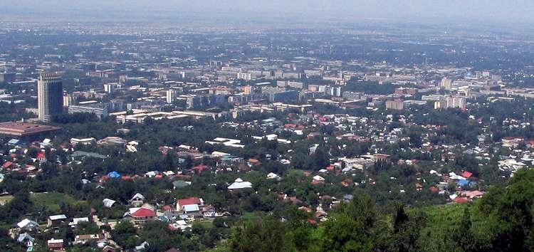
Almaty. Source: Wikimedia Commons
Countries and Regions of the World Collection  Kazakhstan is a landlocked nation of seventeen-and-a-half million people in Central Asia, northwest of China; south of Russia; and, north of Uzbekistan.
A small portion of Kazakhstan lies west of the Ural (Zhayyq) River in eastern-most Europe.
Kazakhstan is the ninth-largest nation in the world; approximately the same size as Western Europe.
|
|

Its major environmental issues include:
- Radioactive or toxic chemical sites associated with former defense industries and test ranges scattered throughout the country pose health risks for humans and animals;
- Industrial pollution is severe in some cities; because the two main rivers that flowed into the Aral Sea have been diverted for irrigation, it is drying up and leaving behind a harmful layer of chemical pesticides and natural salts; these substances are then picked up by the wind and blown into noxious dust storms;
- Water Pollution in the Caspian Sea;
- Soil pollution from overuse of agricultural chemicals and salination from poor infrastructure and wasteful irrigation practices.
It is susceptible to earthquakes in the south and mudslides around Almaty.
Kazakhstan, geographically the largest of the former Soviet republics, excluding Russia, possesses enormous fossil fuel reserves and plentiful supplies of other minerals and metals, such asuranium,copper and zinc. It also has a large agricultural sector featuring livestock and grain.
Ethnic Kazakhs, a mix of Turkic and Mongol nomadic tribes who migrated into the region in the 13th century, were rarely united as a single nation.
The area was conquered by Russia in the 18th century, and Kazakhstan became a Soviet Republic in 1936. During the 1950s and 1960s agricultural "Virgin Lands" program, Soviet citizens were encouraged to help cultivate Kazakhstan's northern pastures. This influx of immigrants (mostly Russians, but also some other deported nationalities) skewed the ethnic mixture and enabled non-ethnic Kazakhs to outnumber natives. Independence in 1991 drove many of these newcomers to emigrate.
Kazakhstan's economy is larger than those of all the other Central Asian states largely due to the country's vast natural resources.
Current issues include: developing a cohesive national identity; expanding the development of the country's vast energy resources and exporting them to world markets; diversifying the economy outside the oil, gas, and mining sectors; enhancing Kazakhstan's economic competitiveness; developing a multiparty parliament and advancing political and social reform; and strengthening relations with neighboring states and other foreign powers.
Russia leases approximately 6000 square kilometers of territory enclosing the Baykonur Cosmodrome; in January 2004, Kazakhstan and Russia extended the lease to 2050.

Geography
Location: Central Asia, northwest of China; a small portion west of the Ural (Zhayyq) River in eastern-most Europe
Geographic Coordinates: 48 00 N, 68 00 E
Area: 2,724,900 sq km (land: 2,699,700 sq km; water; 25,200 sq km)
Land Boundaries: 12,185 km (China 1,533 km, Kyrgyzstan 1,224 km, Russia 6,846 km, Turkmenistan 379 km, Uzbekistan2,203 km)
Kyrgyzstan has yet to ratify the 2001 boundary delimitation with Kazakhstan; field demarcation of the boundaries with Turkmenistan commenced in 2005, and with Uzbekistan in 2004; demarcation is scheduled to get underway with Russia in 2007; demarcation with China was completed in 2002; creation of a seabed boundary with Turkmenistan in the Caspian Sea remains under discussion; Azerbaijan, Kazakhstan, and Russia ratified Caspian seabed delimitation treaties based on equidistance, while Iran continues to insist on a one-fifth slice of the lake.
Coastline: 0 km (landlocked); note - Kazakhstan borders the Aral Sea, now split into two bodies of water (1,070 km), and the Caspian Sea (1,894 km)
Natural Hazards: earthquakes in the south; mudslides around Almaty
Terrain: Vast flat steppe extending from the Volga in the west to the Altai Mountains in the east and from the plains of western Siberia in the north to oases and deserts of Central Asia in the south. The highest point is Khan Tangiri Shyngy (Pik Khan-Tengri) 6,995 m; and, the lowest point is Vpadina Kaundy -132 m)
Source: Philippe Rekacewicz, Emmanuelle Bournay, UNEP/GRID-Arendal
Climate: continental, cold winters and hot summers, arid and semiarid
Ecology and Biodiversity

Source: World Wildlife Fund
- Caspian lowland desert
- Pontic Steppe
- Kazakh semi-desert
- Central Asian northern desert
- Central Asian riparian woodlands
- Kazakh steppe
- Kazakh upland
- Kazakh forest steppe
- Altai montane forest and forest steppe
- Altai steppe and semi-desert
- Altai alpine meadow and tundra
- Junggar basin semi-desert
- Emin Valley steppe
- Tian Shan montane steppe and meadows
- Tian Shan foothill arid steppe
- Tian Shan montane confer forests
- Gissaro-Alai open woodlands
- Altai-Western Tian Shan steppe
- Central Asia semi desert
See also
Biological diversity in the mountains of Central Asia
|
|
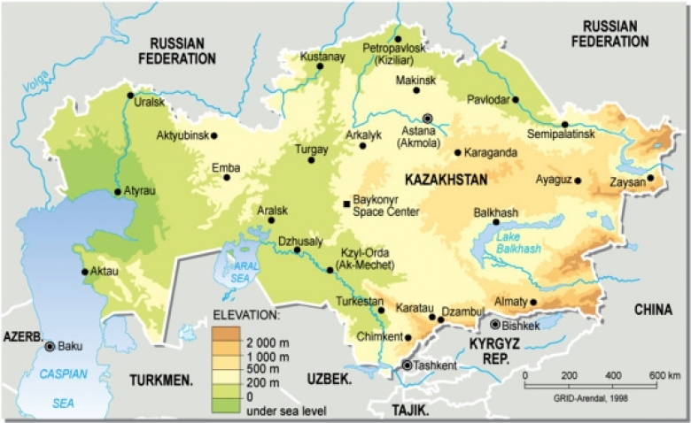
| The steppes of central Kazakshtan (Aqmola Province), as seen from a train approaching Astana from the north. Source:Vladimir Menkov |
|
|
| Almaty, the largest city in Kazakhstan. Source: Wikimedia Commons. |
|
|
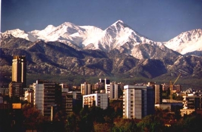
| Satellite view of Astana, the capitol city of Kazakhstan. Source: CNES - SPOT Image. |
|
|
|
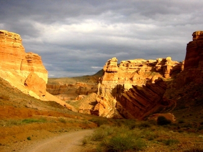
Charyn river canyon in Charyn National Park, in eastern Kazakhstan. Source: Jonas Satkauskas |
|
|
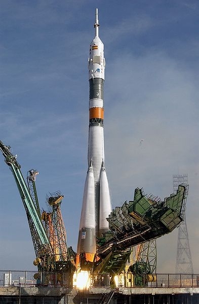
| Launch of a Soyuz TMA-3 vehicle from the Baikonur Cosmodrome in Kazakhstan October 18, 2003, carrying astronauts of several nations to the International Space Station. Source: NASA/Bill Ingalls |
|
|
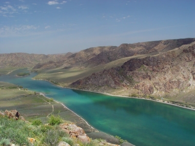
| Ili River. Source: Wikimedia Commons |
People and Society
Population: 17,522,010 (July 2012 est.)
Kazakhstan is very ethnically diverse, with only a slight majority of Kazakhstanis being ethnic Kazakh. Other ethnic groups include Russian, Ukrainian, Uzbek, German, and Uyghur. Religions are Sunni Muslim, Russian Orthodox, Protestant, and other. Kazakhstan is a bilingual country. The Kazakh language has the status of the "state" language, while Russian is declared the "official" language. Russian is used routinely in business; 64.4% of the population speaks the Kazakh language. Education is universal and mandatory through the secondary level, and the literacy rate is 98.4%.
Ethnic Groups: Kazakh (Qazaq) 63.1%, Russian 23.7%, Uzbek 2.8%, Ukrainian 2.1%, Uighur 1.4%, Tatar 1.3%, German 1.1%, other 4.5% (2009 census)
Age Structure:
0-14 years: 21.6% (male 1,709,929/female 1,637,132)
15-64 years: 71% (male 5,373,755/female 5,654,461)
65 years and over: 7.4% (male 392,689/female 754,407) (2011 est.)
Population Growth Rate: 1.235% (2012 est.)
Birthrate: 20.44 births/1,000 population (2012 est.)
Death Rate: 8.52 deaths/1,000 population (July 2012 est.)
Net Migration Rate: 0.43 migrant(s)/1,000 population (2012 est.)
Urbanization: 59% of total population (2010) growing at an annual rate of change of 1.3% (2010-15 est.)
Life Expectancy at Birth: 69.63 years country comparison to the world: 148
male: 64.34 years
female: 74.59 years (2012 est.)
Total Fertility Rate: 2.41 children born/woman (2012 est.)
Languages: Kazakh (Qazaq, state language) 64.4%, Russian (official, used in everyday business, designated the "language of interethnic communication") 95% (2001 est.)
Literacy (age 15 and over can read and write): 99.5%
History
Nomadic tribes have been living in the region that is now Kazakhstan since the first century BC, although the land has been inhabited at least as far back as the Stone Age. From the fourth century AD through the beginning of the 13th century, the territory of Kazakhstan was ruled by a series of nomadic nations. Following the Mongolian invasion in the early 13th century, administrative districts were established under the Mongol Empire, which eventually became the territories of the Kazakh Khanate. The major medieval cities of Taraz and Turkestan were founded along the northern route of the Great Silk Road during this period.
Traditional nomadic life on the vast steppe and semi-desert lands was characterized by a constant search for new pasture to support the livestock-based economy. The Kazakhs emerged from a mixture of tribes living in the region in about the 15th century and by the middle of the 16th century had developed a common language, culture, and economy. In the early 1600s, the Kazakh Khanate separated into the Great, Middle and Little (or Small) Hordes--confederations based on extended family networks. Political disunion, competition among the hordes, and a lack of an internal market weakened the Kazakh Khanate. The beginning of the 18th century marked the zenith of the Kazakh Khanate. The following 150 years saw the gradual colonization of the Kazakh-controlled territories by tsarist Russia.
The process of colonization was a combination of voluntary integration into the Russian Empire and outright seizure. The Little Horde and part of the Middle Horde signed treaties of protection with Russia in the 1730s and 1740s. Major parts of the northeast and central Kazakh territories were incorporated into the Russian Empire by 1840. With the Russian seizure of territories belonging to the Senior Horde in the 1860s, the tsars effectively ruled over most of the territory belonging to what is now the Republic of Kazakhstan.
The Russian Empire introduced a system of administration and built military garrisons in its effort to establish a presence in Central Asia in the so-called "Great Game" between it and Great Britain. Russian efforts to impose its system aroused the resentment of the Kazakh people, and by the 1860s, most Kazakhs resisted Russia's annexation largely because of the disruption it wrought upon the traditional nomadic lifestyle and livestock-based economy. The Kazakh national movement, which began in the late 1800s, sought to preserve the Kazakh language and identity. There were uprisings against colonial rule during the final years of tsarist Russia, with the most serious occurring in 1916. The destruction of the nomadic life, prior to and during the Communist period, created a Kazakh diaspora in neighboring countries, especially western China. Since independence in 1991, the government has encouraged the return of ethnic Kazakhs by offering subsidies for returnees.
Although there was a brief period of autonomy during the tumultuous period following the collapse of the Russian Empire, the Kazakhs eventually succumbed to Soviet rule. In 1920, the area of present-day Kazakhstan became an autonomous republic within Russia and, in 1936, a Soviet republic.
Soviet repression of the traditional elites, along with forced collectivization in late 1920s-1930s, brought about mass hunger and starvation, leading to civil unrest. Soviet rule, however, took hold, and a communist apparatus steadily worked to fully integrate Kazakhstan into the Soviet system. Kazakhstan experienced population inflows of thousands exiled from other parts of the Soviet Union during the 1930s and later became home for hundreds of thousands evacuated from the Second World War battlefields. The Kazakh Soviet Socialist Republic (SSR) contributed five national divisions to the Soviet Union's World War II effort.
The period of the Second World War marked an increase in industrialization and increased mineral extraction in support of the war effort. At the time of Soviet leader Josif Stalin's death, however, Kazakhstan still had an overwhelmingly agricultural-based economy. In 1953, Soviet leader Nikita Khrushchev initiated the ambitious "Virgin Lands" program to turn the traditional pasturelands of Kazakhstan into a major grain-producing region for the Soviet Union. The Virgin Lands policy, along with later modernizations under Soviet leader Leonid Brezhnev, sped up the development of the agricultural sector, which to this day remains the source of livelihood for a large percentage of Kazakhstan's population.
Growing tensions within Soviet society led to a demand for political and economic reforms, which came to a head in the 1980s. In December 1986, mass demonstrations by young ethnic Kazakhs took place in Almaty to protest Moscow's installment of a non-Kazakhstani First Secretary as leader. Soviet troops suppressed the unrest, and dozens of demonstrators were jailed. In the waning days of Soviet rule, discontent continued to grow and find expression under Soviet leader Mikhail Gorbachev's policy of glasnost. Caught up in the groundswell of Soviet republics seeking greater autonomy, Kazakhstan declared its sovereignty as a republic within the Union of Soviet Socialist Republics (U.S.S.R.) in October 1990. Following the August 1991 abortive coup attempt in Moscow and the subsequent dissolution of the Soviet Union, Kazakhstan declared independence on December 16, 1991.
The years following independence have been marked by significant reforms to the Soviet command-economy and political monopoly on power. Under Nursultan Nazarbayev, who initially came to power in 1989 as the head of the Kazakh Communist Party and was eventually elected President in 1991, Kazakhstan has made significant progress toward developing a market economy, for which it was recognized by the United States in 2002. The country has enjoyed significant economic growth since 2000, partly due to its large oil, gas, and mineral reserves.
Government
Kazakhstan is a constitutional republic with a strong presidency. The president is the head of state. The president also is the commander in chief of the armed forces and may veto legislation that has been passed by the Parliament. President Nursultan Nazarbayev has been in office since Kazakhstan became independent. In 1995, President Nazarbayev called for a referendum that expanded his presidential powers: only he can initiate constitutional amendments, appoint and dismiss the government, dissolve Parliament, call referenda, and appoint administrative heads of regions and Astana and Almaty. The prime minister, who serves at the pleasure of the president, chairs the Cabinet of Ministers and serves as Kazakhstan's head of government. There are three deputy prime ministers and 17 ministers in the Cabinet.
In December 2005, President Nazarbayev won a new 7-year term in an election that the Organization for Security and Cooperation in Europe said fell short of international standards. Official results gave the president 91% of the vote, although independent exit polls found this figure to be somewhat inflated. Opposition candidates Zharmakhan Tuyakbay (For a Just Kazakhstan) and Alikhan Baymenov (Ak Zhol) were able to compete freely in this election.
Kazakhstan has a bicameral Parliament, comprised of a lower house (the Mazhilis) and upper house (the Senate). Ninety-eight members of the Mazhilis are elected by a party-list vote. Nine members of the Mazhilis are elected by the Assembly of Peoples of Kazakhstan. The Senate has 47 members. Two senators are selected by each of the elected assemblies (Maslikhats) of Kazakhstan's 16 principal administrative divisions (14 regions, or oblasts, plus the cities of Astana and Almaty). The president appoints the remaining fifteen senators. Mazhilis deputies, the government, and the president have the right of legislative initiative, though the government proposes most legislation considered by the Parliament.
President Nazarbayev's Nur Otan party won the August 2007 elections to the Mazhilis. None of the remaining political parties won a seat during the elections, which the Organization for Security and Cooperation in Europe said fell short of international standards.
Government Type: republic; authoritarian presidential rule, with little power outside the executive branch
Capital: Astana - 650,000 (2009)
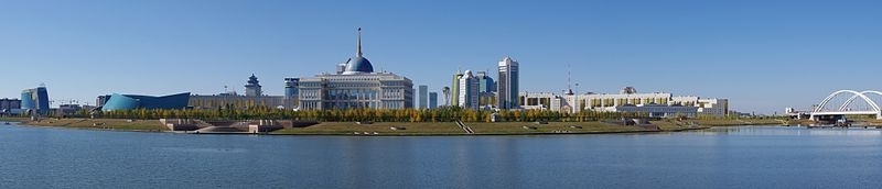
Central Downtown Astana pamorama: the domed building in the middle is the Ad Orda Presidential Palace. The wave-like building on the left is the Kazakhstan Central Concert Hall. Source: Ken and Nyetta/Flickr
Other Major Cities: Almaty 1.383 million (2009), Karaganda 453,400, Shymkent 545,400, Taraz 340,000, Ust-Kamenogorsk 310,000, Pavlodar 300,000
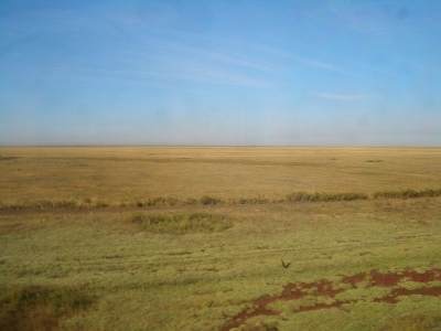
A view of downtown Almaty from Kok Tobe, a mountain on the south-eastern outskirts of the city. Source: Wikimedia Commons.
Independence Date: 16 December 1991 (from the Soviet Union)
Administrative Structure:It is divided into 14 oblasts and the two municipal districts of Almaty and Astana. Each is headed by an akim (provincial governor) appointed by the president. Municipal akims are appointed by oblast akims. The Government of Kazakhstan transferred its capital from Almaty to Astana on June 10, 1998. 14 provinces (oblystar, singular - oblys) and 3 cities* (qalalar, singular - qala); Almaty Oblysy, Almaty Qalasy*, Aqmola Oblysy (Astana), Aqtobe Oblysy, Astana Qalasy*, Atyrau Oblysy, Batys Qazaqstan Oblysy Kazakhstan (Oral), Bayqongyr Qalasy [Baykonur]*, Mangghystau Oblysy (Aqtau), Ongtustik Qazaqstan Oblysy Kazakhstan (Shymkent), Pavlodar Oblysy, Qaraghandy Oblysy, Qostanay Oblysy, Qyzylorda Oblysy, Shyghys Qazaqstan Oblysy Kazakhstan (Oskemen), Soltustik Qazaqstan Oblysy (Petropavlovsk), Zhambyl Oblysy (Taraz)

Source: Tom Bernard/Wikimedia Commons
Legal System: civil law system influenced by Roman-Germanic law and by the theory and practice of the Russian Federation. Kazakhstan has not submitted an International Court of Justice (ICJ) jurisdiction declaration; non-party state to the International Criminal court (ICCt)
International Environmental Agreements
Kazakhstan is party to international environmental treaties on: Air Pollution (Air pollution), Biodiversity, Climate Change, Desertification, Endangered Species, Environmental Modification, Hazardous Wastes, Ozone Layer Protection, Ship Pollution, Wetlands.
Water
Total Renewable Water Resources: 109.6 cu km (1997)
Freshwater Withdrawal: 35 cu km/yr (2% domestic, 17% industrial, 82% agricultural). Per capita: 2,360 cu m/yr (2000)
See: Water profile of Kazakhstan
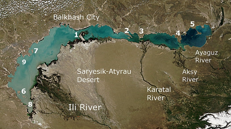
Lake Balkhash and the surrounding area viewed from space. [1] Saryesik peninsula, [2] Baygabyl Peninsula, [3] Balai Peninsula, [4] Shaukar Peninsula, [5] Kentubek Peninsula, [6] Basaran and Ortaaral Islands, [7] Tasaral Island, [8] Shempek Bay, [9] Saryshagan Bay. Source: NASA/Wikimedia Commons
Agriculture
Agriculture accounted for 5.82% of Kazakhstan's GDP in 2007. Grain (Kazakhstan is the seventh-largest producer of wheat in the world) and livestock are the most important agricultural commodities. Agricultural land occupies more than 220 million hectares, about 68% of which consists of pasture and hay land. Chief livestock products are dairy goods, leather, meat, and wool. The country's major crops include wheat, barley, cotton, and rice. Wheat is the leading agricultural commodity in Kazakhstan's export trade. Kazakhstan harvests 14-15 million tons of wheat per year.
Agricultural products: grain (mostly spring wheat), cotton; livestock
Irrigated Land: 35,560 sq km (2008)
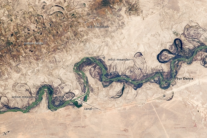
Central Asia’s most important cotton-growing region is concentrated in the floodplain of the Syr Darya. The river was one of the farthest points reached by the ancient Greek leader Alexander of Macedon (or Alexander the Great).
The floodplain is shown here as a tangle of twisting meanders and loops (image center). The darkest areas are brushy vegetation along the present course (filled with blue-green water); wisps of vegetation are also visible along flanking swampy depressions, or sloughs. An older floodplain appears as more diffuse dark vegetation (image upper left), where relict bends are overlain by a rectangular pattern of cotton fields. The straight channel of a new diversion canal—one of 16 from this point downstream—can be seen along the east bank of the river. The older floodplain is fed from the Chardara Reservoir, immediately upstream (not shown). Half the river flow is controlled from reservoirs, and half from direct water take-off from canals. In contrast to the intensive agricultural use of water shown here, water control in the mountain valleys upstream is oriented more toward power generation.
The river flows for 2,200 kilometers, from the Tien Shan Mountains west and northwest to the Aral Sea—the dying waterbody at the low point of the basin. Water has been withdrawn from the river for agriculture for many decades. Although the Syr Darya is the second largest river flowing into the Aral Sea, its discharge is not very large and it is easily depleted. Control of the river is vested in the Syr Darya Basin Water Organization, run by nations with territory in the watershed. Some of the organization’s main efforts include accurate gauging of water use and repair of canals to reduce widespread water leakage.
Alexander the Great reached the Syr Darya in 329 BCE. On the north bank of the river (just beyond the lower left of this image) his army clashed with the local nomads. The river is consequently better known in the West by its Greek name, Jaxartes. From here, Alexander marched south through Afghanistan to the Indus River plains in Pakistan before starting the long march back. He died before reaching his homeland.
Photo courtesy of NASA (2010). Caption by M. Justin Wilkinson, NASA-JSC.
Resources
Oil, gas, and mineral exports are key to Kazakhstan's economic success. Since 1993, Kazakhstan's extractive industries have attracted $30.7 billion in foreign investment, which represents almost 76% of the total foreign direct investment in Kazakhstan for that period. Kazakhstan has significant deposits of coal, iron ore, copper, zinc, uranium, and gold.
Natural Resources: major deposits of petroleum, natural gas, coal, iron ore, manganese, chrome ore, nickel, cobalt, copper, molybdenum, lead, zinc, bauxite, gold, uranium.
Land Use:
Economy
Kazakhstan, geographically the largest of the former Soviet republics, excluding Russia, possesses enormous fossil fuel reserves and plentiful supplies of other minerals and metals, such as uranium, copper, and zinc. It also has a large agricultural sector featuring livestock and grain.
In 2002 Kazakhstan became the first country in the former Soviet Union to receive an investment-grade credit rating, and from 2000 through 2007, Kazakhstan's economy grew more than 9% per year. Extractive industries, particularly hydrocarbons and mining, have been the engines of this growth. However, geographic limitations and decaying infrastructure present serious obstacles.
Landlocked, with restricted access to the high seas, Kazakhstan relies on its neighbors to export its products, especially oil and gas. Although its Caspian Sea ports and rail lines carrying oil have been upgraded, civil aviation has been neglected.
Telecoms are improving, but require considerable investment, as does the information technology base.
Supply and distribution of electricity can be erratic.
At the end of 2007, global financial markets froze up and the loss of capital inflows to Kazakhstani banks caused a credit crunch. The subsequent and sharp fall of oil and commodity prices in 2008 aggravated the economic situation, and Kazakhstan plunged into recession. While the global financial crisis took a significant toll on Kazakhstan's economy, it has rebounded well. In response to the crisis, Kazakhstan's government devalued the tenge (Kazakhstan's currency) to stabilize market pressures and injected $19 billion in economic stimulus.
Rising commodity prices have helped revive Kazakhstan's economy, which registered roughly 7% growth in 2010-11.
Despite solid macroeconomic indicators, the government realizes that its economy suffers from an overreliance on oil and extractive industries, the so-called "Dutch disease." In response, Kazakhstan has embarked on an ambitious diversification program, aimed at developing targeted sectors like transport, pharmaceuticals, telecommunications, petrochemicals and food processing.
In 2010 Kazakhstan joined the Belarus-Kazakhstan-Russia Customs Union in an effort to boost foreign investment and improve trade relationships.
The government expects to join the World Trade Organization in 2012, which should also help to develop the manufacturing and service sector base.
See: Energy profile of Kazakhstan
GDP: (Purchasing Power Parity): $216.4 billion (2011 est.)
GDP: (Official Exchange Rate): $180.1 billion (2011 est.)
GDP- per capita (PPP): $13,000 (2011 est.)
GDP- composition by sector:
agriculture: 5.2%
industry: 37.9%
services: 56.9% (2011 est.)
Industries: oil, coal, iron ore, manganese, chromite, lead, zinc, copper, titanium, bauxite, gold, silver, phosphates, sulfur, uranium, iron and steel; tractors and other agricultural machinery, electric motors, construction materials
Currency: Tenge (KZT)