Ischigualasto-Talampaya, Argentina (About the EoE)
Contents
- 1 Ischigualasto-Talampaya, Argentina
- 1.1 Geographical location
- 1.2 Date and history of establishment
- 1.3 Area
- 1.4 Land tenure
- 1.5 Altitude
- 1.6 Physical features
- 1.7 Climate
- 1.8 Vegetation
- 1.9 Fauna
- 1.10 Cultural heritage
- 1.11 Local human population
- 1.12 Visitors and visitor facilities
- 1.13 Scientific research and facilities
- 1.14 Conservation value
- 1.15 Conservation management
- 1.16 Further Reading
Ischigualasto-Talampaya, Argentina
Geographical location
Ischigualasto Provincial Park (29°55’S-68°06’W) and Talampaya National Park (30°02’S-67°48’W) are together a World Heritage Site consisting of two contiguous conservation units located on the border between the provinces of San Juan and La Rioja, in north-western Argentina. Ischigualasto Provincial Park is a protected area crossing the border between the two provinces and lying between 29°55’S-68°06’W; Talampaya National Park lies entirely in the Province of La Rioja and its coordinates are 30°02’S-67°48’W.
Date and history of establishment
Ischigualasto Provincial Park was designated as such by Provincial Law No. 3,666 of November 3, 1971 (San Juan Province). Talampaya was first declared as Provincial Park by Provincial Law No. 3,803 of 1975 (La Rioja Province). In 1997, Talampaya was re-classified as National Park by National Law No. 24,846; as such, its administration and management was transferred to the National Parks Administration (APN) and is regulated by National Law No. 22,531 of 1980.
Area
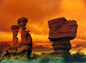 Ischigualasto, Argentina. (Source: Escuela de Ingeniería de Caminos de Montaña, National University of San Juan)
 The nominated site comprises a total area of 275,369 hectares (ha). Ischigualasto Provincial Park has an area of 60,369 ha, including a buffer zone and service area of approximately 12,000 ha. Talampaya National Park has a total extent of 215,000 ha, with no designated buffer zone, though a four-zone scheme is proposed, comprising off limits, extensive recreational use, intensive recreational use and recuperation.
Land tenure
All properties in the nominated site belong to the national or provincial governments. Ischigualasto is registered as of public domain of the San Juan Province. Land ownership within Talampaya National Park has recently been transferred from provincial (La Rioja Province) to national jurisdiction.
Altitude
Average altitude is approximately 1,200 meters (m) above the sea level, with barren peaks reaching up to 3,000 m.
Physical features
The Ischigualasto-Talampaya region is a desert area forming the western border of the Sierras Pampeanas of central Argentina. The nominated site constitutes almost the entire sedimentary basin known as the Ischigualasto-Villa Union Triassic basin. This formation consists of continental sediments deposited by rivers, lakes and swamps over a period of time covering the entire Triassic Period, from approximately 245 to 208 million years before present times. The river deposits include large areas of floodplains with over-bank and crevasse splay sediments that indicate rapid flooding, probably after monsoon type storms. Lake and swamp deposits contain large amount of fossil plants, some of them forming coal seams and others preserved as mummification of actual species, an extremely rare form of preservation known from very few localities. Six geologic formations make up the Triassic basin, the earliest of which are the Talampaya and Tarjados formations, red sandstone that form the impressive cliffs of the Talampaya National Park. The remaining formations are composed of lake beds, swamps, river channels and floodplain deposits. Within the sediments are frequent layers of volcanic ash, which allow radiometric dating of the formations and contribute significantly to the mineral content of the sediments. Three of these formations contain the abundant vertebrate fossils that document key changes in terrestrial fauna. In addition, five formations contain abundant fossil flora that documents climatic changes and dietary conditions for animals. The arid badlands of Ischigualasto have a bizarre and rugged terrain that has given it the popular name "Valley of the Moon".
Ischigualasto-Talampaya is the only place on earth revealing the complete sequence of fossiliferous continental sediments representing the entire Triassic Period of geological time. The fossil-bearing strata here contain some of the oldest known dinosaur remains and document the transition from Early Triassic mammalian ancestors to the age of dinosaur dominance in the Late Triassic. Although there are Triassic sites on other continents, including some with dinosaur fossils such as the Chinle Formation in Arizona, they are generally small and scattered with limited fossil abundance, and they represent only a restricted period of the 45 million years of Triassic time.
Drainage is through temporary streams, which remain dry for most of the year, but are subject of flash floods with the potential to move large boulders. Soils in the area are immature, consisting principally of sand and gravel of various grades. Due to the high evaporation rate, the soils are usually quite saline.
Climate
The nominated site has a dry climate, with air humidity usually no higher than 20%. Average annual rainfall is less than 200 millimeters (mm) which are largely concentrated on the summer months (December to March), sometimes causing flash floods and rapid erosion. Temperatures tend to be extreme, 45° degrees Celsius (°C) in summer and –10°C in winter.
Vegetation
Ischigualasto-Talampaya has a sparse vegetation characterized by xeric shrubs and cactus, and mesquite Prosopis sp. and quebracho Aspidosperma sp. trees. A total 172 species of plants has been recorded from the area. Plants cover between 10 and 20 percent of the land. At least six plant species are regarded as being of special value, including chilca Baccharis sp., false broom and verdolaga Halophytum ameghinoi. The plant life of the parks is still not completely known. The vegetation has been broadly mapped throughout and an inventory of plants in Ischigualasto Provincial Park has been recently completed. Regarding the fossil flora, some 100 species of fossil plants have been identified. The site also contains huge petrified tree trunks of Protojuniperoxylon ischigualastianus more than 40 m height, which attest to a very rich Triassic vegetation. The proper affinities of these trees are not known, but their wood resembles that of the Araucariaceae. Fossil ferns, such as Cladophlebis sp. and horsetails have also been found.
Fauna
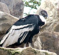 The Andean condor ranges over the Andes mountains from Venezuela to Chile. (Source: USAID)
 Ischigualasto-Talampaya has a fauna typical of the arid regions of western Argentina, with no less than 20 species of mammals, 36 birds, and 20 reptiles and amphibians. In the Ischigualasto Valley there are now three herds of guanaco Lama guanicoe, numbering at least 60 individuals. In the surrounding alluvial plains, lesser rhea Pterocnemia pennata is frequent. Several animal species are regarded as being of special value because they are either endemic, nationally threatened or culturally valuable, including Andean condor Vultur gryphus, chestnut canastero Thripophaga steinbachi, sandy gallito Teledroma fuscus, puma Felis concolor, guanaco Lama guanicoe, mara Dolychotus patagonum and viscacha Lagidium viscacia. The site has been nominated as a natural site, however, mainly on the basis of its importance as fossil site, representative of the development of vertebrate fauna during the Tertiary Period. The following description therefore relates to the fossil fauna only.
Currently, some 56 genera of fossil vertebrates have been recorded from the nominated site, including fish, amphibians, and a great variety of reptiles and direct mammalian ancestors. Most of them come from three of the six geologic formations, although it should be noted that around 60% of the area remains largely unexplored. The most significant formations are the following: (a) Ischichuca-Chañares: this represents an ancient lake bed (Ischichuca) and a shallow water beach area (Chañares). Fossil vertebrates are particularly abundant in the Chañares section, and most of them belong to therapsids, which is an ancestral group of mammals. Also present are fossils of a group termed Archosauria, which consists of animals that are ancestors of the dinosaurs (and by extension birds), crocodiles and lizards. (b) Ischigualasto: this includes striking white and variegated sediments that form the valley known as Hoyada de Ischigualasto. These sediments represent the lush meadows and floodplains on either side of an ancient river that flowed from west to east during the Triassic. Literally thousands of specimens have been collected from this formation, including reptiles, amphibians, therapsids and a great number of plants. Vertebrate specimens contain the earliest dinosaur Eoraptor and its more advanced contemporary Herrerosaurus; and (c) Los Colorados: this is the last in the series of Triassic data and represents the beginning of the Age of the Dinosaurs. Most of the fossils are found in the uppermost levels of the formation and consist almost entirely of archosaurs, including large herbivorous and carnivorous species, true primitive crocodiles and primitive true mammals about the size of a rat.
Cultural heritage
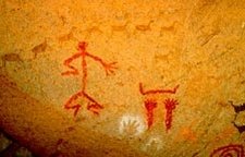 Argentinian rock art depicting a human figure. (Source: Secretaría de Ambiente y Desarrollo Sustentable)
 Before the period of Spanish conquest the area was inhabited by several groups of aborigines, usually semi-nomadic hunters and gatherers. The cultural value of Ischigualasto-Talampaya is of great significance, even though a detailed study of rock art, artifacts and archaeological sites has only recently begun. The site lies on the southernmost area of late Inca influence. Close to the two parks is Mount Famatima, the highest peak in South America outside of the Andes, and a place where the Inca mined for gold. Cultural artifacts date approximately from 600 BC to the time of the Spanish conquest. Ancient cultures known as the Cultura de la Fortuna and Cultura de la Aguada date from 600 BC to approximately 1000 AD. Later tribes known as Diaguita and Huarpes were present up to the time of the arrival of the conquistador. A large number of site containing extensive examples of pre-Hispanic rock art have been identified in the area. At Talampaya, 32 sites have been unearthed and are easily accessible. At Ischigualasto, six sites of rock art have been discovered. In addition to these, cave and rock overhang habitation sites, as well as burial sites, campgrounds and tool-making areas have also been found. It is possible to classify much of the rock art in terms of geometric figures, human figures and combined scenes. Geometric designs include simple lines, zigzag lines, curved lines, various rectangular forms, circular forms, the so-called "sand clock" and a radiating sun figure. The repertoire of human figures includes isolated figures, pairs and groups. Some of these figures are static, some are in action positions. Some have decorations on the head or around the body. Animals are represented by individual species, especially guanaco, in groups of two or more. Some are in dynamic positions, most are static. Some of the animal figures appear to represent masks worn by dancers or important members of the group. Animal and human footprints are also common in the rock art. Among the animal prints are found puma, rhea and guanaco. Additional scenes combine animal and human drawings, sometimes showing a direct relationship between the human and the animal.
Local human population
Early settlements in the area were along the watercourses near the mountains and in areas where natural springs were found. Subsistence farming and cattle raising were the main productive activities, with some small scale mining. During the last half of the XIX Century large cattle drives were organized to deliver beef to the miners across the Andes in Chile. Thousands of head of cattle were driven from central Argentina across the Ischigualasto-Talampaya area, wintered in the pre-cordillera area and then crossed into Chile the following summer. Remnants of this activity are found throughout the whole area in the form of camps, temporary shelters and artifacts. Early in the XX Century the coal beds of the Los Rastros formation in Ischigualasto were mined, but due to the poor quality of the coal the activity did not last long. Currently, there are no towns, populations or private property within the nominated site. Approximately 10 km south of the entrance to Ischigualasto is the small village of Baldecitos inhabited by eleven families. Larger towns with full service facilities, lodging, commerce, medical care and populations between 2,000-3,000 people are San Agustín, located 87 km south of Ischigualasto and Villa Union, located 70 km north of Talampaya.
Visitors and visitor facilities
The combination of scientific value and natural beauty has made the nominated site a major tourist attraction in Argentina. Most of the visitors are drawn by the unspoiled beauty of the area and the impressive scenery that is unique and totally different from other natural areas. At present, there are no lodging facilities at either of the conservation units. Primitive camping is permitted in the buffer zone at Ischigualasto Provincial Park. Ischigualasto has a small visitor center with an interpretive display, four toilets and a single ranger’s residence. This center has recently been extended and a further extension is planned for 2001. Talampaya has a reception center, parking area, toilets, and an office for tour guides and concessionaires. The division of the Park into five different zones has recently been proposed . Such a division includes two separate zones of recreational use, one extensive and one intensive, on which all the activities of tourism will be concentrated. The extensive use zone consists of largely natural areas, which can be visited by a relatively low number of tourists; the intensive use zone is composed of somewhat modified areas, where the infrastructure of the Park is concentrated. Small buffet style food services are available at both parks. Walking trails and interpretive signs are scarce.
In 1998, 34,000 tourists visited the area; nearly all of them combined their visit to include both sites. Tourists are accompanied by ranger/guides and normally carried in park vehicles, though escorted private vehicles are permitted at Ischigualasto. A recent analysis indicates that without any improvement in roads or services during the next ten years, the number of visitors will increase to at least 100,000 per year. If lodging and other services are added, the estimated increase will be 600,000. Approximately 7% of tourists are from countries outside Argentina, mostly from Brazil, Japan, Europe and USA. Most of the national tourist come from Buenos Aires, followed by Cordoba and Mendoza. In addition, 200 school buses visited the parks in 1998 and numerous scientific delegations from universities and research centers from around the world. At present, the economic impact for the area is limited principally to the entrance fees at the parks. Some secondary benefits are derived to the nearby towns of San Agustin, in the Province of San Juan, and Patquia and Villa Union, in La Rioja Province.
Scientific research and facilities
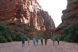 Talampaya park. (Source: University of Wisconsin)
 The area has been subjected to intensive research interest since early in the XX Century. The coal mine fossil footprints were first described in 1929 by the German palaeontologist Friedrich Von Huene. Later the Italo-Argentine geologist Joaquin Frenguelli collected the first fossil skull of a cynodont from the Ischigualasto formation and sent it to the La Plata Museum where it was described by the palaeontologist Angel Cabrera in 1944. The true importance and fossil-richness of this region was not fully appreciated until the first joint Argentine-US expeditions to Ischigualasto were made in the 1950s. In 1958, an expedition from Harvard University and the Argentine Museum of Natural History made the first expedition to Ischigualasto and discovered the Chañares locality in the Talampaya area, adding to the scientific value of the site. Later work was carried out by the University of Tucumán under the direction of Dr Oswaldo Reig and José Bonaparte, who also discovered the importance of the upper portion of Los Colorados formation as a fossil site. Beginning in 1970, the provincial universities of San Juan and La Rioja began extensive field work in the area. Some of the bibliography which resulted from these as well as ulterior expeditions to the site include Bonaparte (1979), Rogers (1997), Sereno & Novas (1992) and Zago (1995). There are no scientific facilities in the parks. However, specimens from the site, both palaeontological and biological, are fully catalogued and curated by expert staff at the Museum of Natural Sciences, under the auspices of the University of San Juan. This is the principal research and interpretive center for the parks, with a major new display of fossils and Triassic palaeoenvironments planned. Researchers from the University of La Rioja are also active at the site. Specimens are freely available for study, but strict laws control all collecting of specimens and all research is supervised by the University of San Juan.
Conservation value
Ischigualasto-Talampaya comprise a combination of unique and valuable geologic, palaeontological, archaeological, biologic and ecological assets The site represents the only known area in the world that contains a complete sequence of continental sediments with abundant fossil flora and fauna of the Triassic Period. The fossil plants and vertebrates of Ischigualasto are of great importance to the sciences of palaeontology and evolutionary biology. The plants provide a greater understanding of the drastic changes that took place at the end of the Permian Period, when approximately 80% of the world’s flora and fauna became extinct and the survivors began a new chapter in world history at the beginning of the Triassic. The complete sequence of rock (Rock cycle)-time for the Triassic Period found in Ischigualasto-Talampaya is one of the great scientific treasures of the world. The wealth of fossils found there continues to amaze and impress the world of palaeontology. Currently, at least 56 genera of vertebrates are known from the site, the number of species has not yet been determined, and at least 100 species of fossil plants, with more being added as research continues. The extant flora and fauna also include species of conservation importance. The unique desert environment, preserved in its natural stage, contains several endemic species, some of which are rare and considered as endangered (IUCN Red List Criteria for Endangered) or vulnerable.
Conservation management
APN has well developed management plans for all of the national parks it administers. These plans are based on international standards and local needs and conditions. However, the management plan for Talampaya National Park is still under preparation and requires public consultation. Ischigualasto Provincial Park currently has a three year study under way by the University of San Juan to establish the scientific basis for a comprehensive management plan to be implemented by the Secretariat of Environmental Planning and the Provincial Tourism Agency (EnProTur). The National Secretariat of Tourism also contributes a global perspective to the planning procedures for the administration of the nominated site. The management plans will be in accordance with the ISO 14000 standards. Their objectives are to preserve and protect the natural areas as a permanent testimony of rare and completely natural scenic and scientific areas. Secondly, the objective will be to develop plans for the rationale use that will fulfill the needs of visitors without degrading the natural system. A third objective is to serve as an educational instrument for increasing the public awareness. The national and provincial authorities have begun the process of establishing a single cooperative management regime for the two parks. Currently, there is a documented agreement specifying common management objectives, planning processes and zoning procedures, and integrated action in respect of staff training, tourism management, control measures and research, among others. Some actions aimed at the unification of the management of the two sites have recently been agreed. These include: (a) the creation of a Management Coordination Committee; and (b) the exchange of information on research activities and the definition of criteria for permitting future investigations in the two sites.
Management constraints
At present, there are no significant developments in the area. The land is unsuitable for agriculture and cattle raising is only on a small scale. There are no industries. A significant constraint is the rubbish left behind by visitors. In Talampaya there has been some vandalism of rock art, mainly before the designation of the area as protected. Because the parks are not fenced, it is possible for poachers to gain access to the areas on foot, or with horses or mules. Currently, despite frequent patrols, the park staff do not have adequate equipment to detect or intercept these hunters. However, illegal collecting and poaching appear to be minimal. Another management problem consists of the occasional entrance to the site by motorbikes, which gain access by way of stream beds in the outlying areas of the parks that are relatively inaccessible.
Staff
Personnel of the national park consists of two highly trained professional park rangers, and some 17 unofficial interpreter guides drawn from the local community. Scientists from the University of San Juan (Museum of Natural Sciences) and the University of La Rioja serve as advisors and participate in research and activities of environmental monitoring. At Ischigualasto the full time staff consists of one ranger and eight certified guides. Supervisory personnel is provided by the three management agencies: EnProTur, APN and the Museum of Natural Sciences of the Province of San Juan.
Budget
The revenues derived from entrance fees, totaling almost US$200,000 annually, are managed by EnProTur and APN. Ischigualasto has no formally assigned budget and there is little operating funding apart from staff wages. The annual budget for Talampaya is US$85,000. The budget already allocated for the year 2001 is US$95,600. Additional funding is provided by subsidies from provincial and national organizations and by research entities such as the universities working in the area.
Further Reading
- Bonaparte, J.F. (1979). Faunas y paleobiogeografía de los tetrápodos mesozoicos de América del Sur. Ameghiniana. Revista de la Asociación Paleontológica Argentina 16(3-4): 217-238.
- Erize, F., Canevari, M., Canevari, P., Costa, G. and Rumboll, M. (1993). Los Parques Nacionales de la Argentina. El Ateneo, Buenos Aires, Lima, Mexico, Barcelona. 238 pp.
- IUCN (1996). 1996 IUCN Red List of Threatened Animals. IUCN, Gland, Switzerland. 368 pp. + Annexes. ISBN: 2831703352.
- Merino, S. (1987). Argentina: protected areas inventory. Unpublished
- Rogers, R.R. (1997). "Ischigualasto Formation", pp.372-374 in Encyclopedia of Dinosaurs, Philip J. Currie & Kevin Padian (eds.), Academic Press, USA.
- SENATUR (1999). A proposal for the nomination of the Natural-Cultural Parks Ischigualasto-Talampaya as a World Heritage Site. 30 pp + Annexes.
- Sereno, P.C.% Novas, F.E. (1992). The complete skeleton of an early dinosaur. Science 258: 1137-1140.
- Sill, W. (1999). The touristic importance of Ischigualasto.
- Sill, W. (2000). Comparison of the world’s Triassic vertebrate localities - a synopsis. Unpublished Ms. 2pp.
- Sylvester, F. and Dellafiore, C. (2000). Parque Nacional Talampaya. Zonificación
- Zago, M. (ed.), (1995). Ischigualasto Talampaya: Tiempo de Dinosaurios. Manrique Zago ediciones, Buenos Aires, 199pp. ISBN: 9509517585.
| Disclaimer: This article is taken wholly from, or contains information that was originally published by, the United Nations Environment Programme-World Conservation Monitoring Centre (UNEP-WCMC). Topic editors and authors for the Encyclopedia of Earth may have edited its content or added new information. The use of information from the United Nations Environment Programme-World Conservation Monitoring Centre (UNEP-WCMC) should not be construed as support for or endorsement by that organization for any new information added by EoE personnel, or for any editing of the original content. |