Iguacu National Park, Brazil
Contents
- 1 Introduction
- 2 Threats to the Site
- 3 Geographical Location
- 4 Date and History of Establishment
- 5 Area
- 6 Land Tenure
- 7 Altitude
- 8 Physical Features
- 9 Climate
- 10 Vegetation
- 11 Fauna
- 12 Cultutral Heritage
- 13 Local Human Population
- 14 Visitors and Visitor Facilities
- 15 Scientific Research and Facilities
- 16 Conservation Value
- 17 Conservation Management
- 18 IUCN Management Category
- 19 Further Reading
Introduction
Iguaçu (also Iguazu) National Park (25° 00'-25° 45'S, 53° 43'-54° 30'W) is a World Heritage Site and lies in the far southwest of Paraná State in Brazil. The Park shares with Iguaçu National Park in Argentina one of the world's largest and most impressive waterfalls, over 2,700 meters (m) wide. The Park is an island of wilderness in the wide Paraná river valley, much of which has been deforested for agriculture. It shelters rare and endangered species (IUCN Red List Criteria for Endangered) of flora and fauna, such as the giant otter and giant ant-eater. Clouds of spray round the waterfall produce lush vegetation.
Threats to the Site
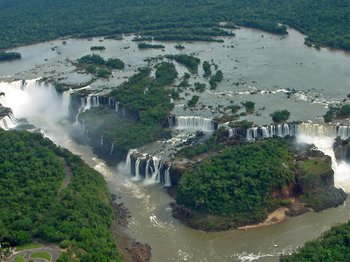 View of Iguaçu falls from the Argentinian side. (Source: Wikimedia Commons)
 The inclusion of the National Park on the List of World Heritage in Danger followed a mission to the site in March 1999. This followed refusal by local people to stop building an illegal road which would have cut the Park in two, also disturbance of wildlife by tourist helicopter flights and the continued lack of any new management plan to deal with threats to the Park. Federal police action closed and destroyed the road in mid 2001 and began to restore the land. The Committee therefore removed the Park's listing, initiated sustainable economic activity to minimize the impact and encouraged cooperation with Iguaçu National Park in Argentina.
Geographical Location
In the far southwest of Paraná State. To the south is the Argentinian border with Iguazu National Park across Rio Iguaçu; to the west, the nearby Paraguayan border. Three towns lie close together west of the park on the tri-state border: in Brazil, the city of Foz do Iguaçu, in Paraguay, Ciudad del Este across the Paraná River and in Argentina, Puerto Iguazu a few kilometers (km) south. The Itaipu hydroelectric dam is 20 km upstream of Foz do Iguaçu on the Paraná river. 25° 00'-25° 45'S, 53° 43'-54° 30'W.
Date and History of Establishment
- 1916: The first measures taken to protect Iguaçu Falls;
- 1936: The National Park established by Federal Decree No.1035 amended and extended by Decrees Nos. 6587 of 1944 and 86676 of 1981, based on the Forestry Code Law No.4471 of 1965 and the National Park Creation and Regulation Decree No. 84017 of 1979.
Area
170,000 hectares (ha) (World Heritage nomination,1984); 170,086 ha (IBDF management plan,1981). The contiguous Iguazu National Park in Argentina is 49,200 ha, the National Reserve, 6,300 ha.
Land Tenure
The management plan states that 168,113 ha are controlled by the IBDF (Instituto Brasileiro de Desenvolvimento Florestal). The World Heritage nomination states that the Federal Government owns the whole area, and that there is no private ownership within the park boundaries.
Altitude
740 m to 150 m.
Physical Features
The main feature is the Iguaçu Falls in the far southwest of the park, where the Rio Iguaçu falls off the edge of the southern [[Brazil]ian] plateau. They are just above the confluence of the Rio Paraná and the Rio Iguaçu which borders the whole southern edge of the park in forested generally flat land of red nutrient-poor semi-lateritic soils. The rocks are mainly Mesozoic basalt lavas interbedded with sandstones into which the river below the falls has cut the 80 m wide gorge of the Garganto do Diablo, a fault-line canyon. The river is about 1,200 m wide at the falls, contains a number of islands, and drops 72 m in 150-300 cataracts over a 2,700 m semicircular ledge cutting a giant staircase down the basalt. Of the total, some 800 m are on the Brazilian side of the border.
Climate
The climate is humid subtropical with over 1,700 millimeters (mm) of annual rainfall and no dry season. The relative humidity is between 80-90%. The mist cloud creates a super-humid microclimate round the falls. Mean temperatures are 15°C in winter and 25°C in summer with an annual mean of 21°C which falls to 19°C above about 500 m.
Vegetation
The Park is almost an island of southwestern Atlantic rainforest in the Paraná river valley which has largely been deforested for intensive agriculture. This humid subtropical rainforest covers about 90% of the park. The lower park is rich in tree ferns Cyatheaceae, lianas and epiphytes, with species of Ilex, Podocarpus, Aspidosperma, Cedrela and Philodendron. There is lush growth within the perpetual mist of spray. The upper park is mainly humid subtropical deciduous forest, but a small area in the northeast of the park has stands of the umbrella-shaped Paraná pine Araucaria angustifolia, here at its western limit, with two palms, the Assai palm Euterpe edulis, of which the heart is eaten, and wild coconut palm Cocos romanzoffiana, also imbuya or 'Brazilian walnut' Phoebe porosa.
Fauna
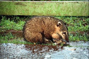 Coatimundi Nasua nasua. (Source: Wikimedia Commons)
 Fauna recorded within the park include giant otter Pteronura brasiliensis (V), La Plata otter Lutra platensis, coatimundi Nasua nasua, ocelot Felis pardalis, jaguar Panthera onca, puma Felis concolor, margay Leopardus wiedii, brocket deer Mazama rufina (LR) and American tapir Tapirus terrestris (LR). Bush dog Speothos venaticus (V) and giant anteater Myrmecophaga tridactyla (V) have also been recorded. There have been reports of black howler monkey Alouatta caraya, capybara Hydrochoerus hydrochaeris and usutu viper Bothrops alternata. Noteworthy birds recorded include solitary tinamou Tinamus solitarius (LR), harpy eagle Harpia harpyia (LR), black-fronted piping guan Pipile jacutinga (V), purplewinged ground dove Claravis godefrida (CR), glaucous macaw Anodorhynchus glaucus (EX), vinaceous-breasted parrot Amazona vinacea (E), red-spectacled parrot Amazona pretrei (E), and white-tailed trogon Trogon viridis, helmeted woodpecker Dryocopus galeatus (E), whitebearded antshrike Biatus nigropectus (V), russetwinged spadebill Platyrinchus leucocoryphus (V) and S.Paulo tyrrannulet Phylloscartes paulistus (V). Broad-nosed caiman Caiman latirostris and dwarf caiman Paleosuchus palpebrosus are also recorded. The presence of black howler monkey is not noted in the management plan, which confirms the presence of all other mammal species. No comprehensive bird list is given in the plan, but it does confirm the presence of the endangered species (IUCN Red List Criteria for Endangered), the glaucus macaw.
Cultutral Heritage
Before the arrival of the Spanish and Portuguese, the area belonged to the Guarani people.
Local Human Population
The population of Foz do Iguaçu has risen from 30,000 at the beginning of the 1960s to over 200,000 in the 1990s. The town is a major tourist destination mainly for people visiting duty free shops across the Paraguayan border in Cuidad del Este.
Visitors and Visitor Facilities
The area is well served by roads, and is close to an airport. There is a large hotel within the park, a heliport, a museum, access roads, interpretive trails, viewpoints and a visitor center, helicopter rides above the falls and boat trips up the river. The Brazilian and Argentinian sides are connected by a bridge downstream from the falls. Foz do Iguaçu, a few kilometers west, is the third largest tourist destination in Brazil, with 160 hotels, mainly serving tourists shopping in Paraguay. In 1994, 970,000 tourists visited the National Park.
Scientific Research and Facilities
Research is under way into otter, giant anteater and harpy eagle and an assessment of the park‘s resources in order to assist management. There is accommodation for scientists and a museum with laboratory facilities.
Conservation Value
The park, with Iguazu National Park in Argentina, surrounds one of the world's greatest waterfalls, 2.7 km in length. Together with the Uruguai Provincial Park in Argentina, the three parks form one of the most extensive remaining tracts of inland Atlantic rainforest. The park harbors threatened fauna including three endangered species (IUCN Red List Criteria for Endangered) of bird.
Conservation Management
The area is managed by the Instituto Brasileiro de Desenvolvimento Florestal (IDBF). Management and public use plans have been developed, and are reportedly being implemented. The park is zoned 80% Intangible which covers most of the central and eastern part of the park - Primitive (4%) - Extensive use (3%) - Intensive use – Recuperation - Special use - Cultural-Historic (13%). Following the closing by federal authorities of a road being built through the middle of the Park, a state and federal government group initiated studies and a project to promote sustainable income generation and employment for surrounding populations through organic agriculture crafts and ecotourism. IUCN and the World Heritage Committee recommended the removal of the Park’s listing in danger after a visit in 2002 which also studied transborder cooperation with Iguazu National Park in Argentina.
Management Constraints
The park lies in an area of intense agricultural development and close to several towns. Enforcement of boundaries is therefore a major difficulty; poaching of game and salmon and fires are particular problems. There are tourist helicopter flights over the falls which disturb the wildlife and some illegal tree-felling of palm trees to collect palm hearts. Heavy siltation, rapid runoff and high diurnal temperature variations are thought to be due to the nearby Itaipu hydroelectric complex which created a 130,000 ha lake (Anthropogenic biomes) and deforested the catchment. There are not enough forest rangers to effectively police so large an area and so many visitors.
In May 1997 a group of some 800 people invaded the park and illegally started to reopen an old colonial road between two local towns which passed through 18 km of the park until it was closed in 1986. The re-opened road would make the park more accessible for hunting, fishing and tree-felling but the conservation authorities were unable to stop its construction because of political pressures. No new management plan to deal with the threats to the Park had been drawn up since the issues were first raised. However, the Federal authorities closed the road in June 2001, set up a police post at the entrance, scarified the whole length and planted 25,000 seedlings to replace the cleared vegetation.
Staff
One director, ten administrative staff, 15 park guards and 17 general workers in 1981 (undated information).
Budget
Cr$ 10,000,000 (about $US600,000) in 1981, with increased expenditure planned for 1982 through 1984, dropping to about Cr$ 5.5 million (US$327,000) per annum subsequently (undated information). In 2000, The Brazilian Institute of Environment and Renewable Natural Resources (IBAMA, Instituto Brasiliero do Meio Ambiente e dos Recursos Naturais Renováveis) allocated US$60,000 to close the road and restore the area.
IUCN Management Category
- II National Park
- Natural World Heritage Site, inscribed 1986. Natural Criteria ii, iv
- Listed as World Heritage in Danger in 1999-2001 due to the construction of a discontinued road splitting the Park.
Further Reading
Some reference materials are available, including aerial photographs, maps and lists of flora and fauna.
- Bailby, E. (1995) The Iguaçu Falls. Unesco Courier Nov. 01 1995.
- Jorge Padua, M., Magnanini, A. & Mittermeier, R. (1974). Brazil's national parks. Oryx 11(4): 452-464.
- IBDF (1981). Plano de Manejo Parque Nacional do Iguaçu. Instituto Brasileiro de Desenvolvimento Florestal, Brasilia.
- IUCN (1985). World Heritage Nomination. Report to UNESCO, Paris.
- UNESCO World Heritage Committee (1997). Report of the 21st Session of the World Heritage Committee, Paris
- UNESCO World Heritage Committee (2001). Report of the 24thSession of the World Heritage Committee, Paris
- UNESCO World Heritage Committee (2002). Report of the 26th Session of the World Heritage Committee, Paris
- Wege, D. & Long, A. (1995). Key Areas for Threatened Birds in the Neotropics. Birdlife International, Cambridge, England. ISBN: 0946888310.
| Disclaimer: This article is taken wholly from, or contains information that was originally published by, the United Nations Environment Programme-World Conservation Monitoring Centre (UNEP-WCMC). Topic editors and authors for the Encyclopedia of Earth may have edited its content or added new information. The use of information from the United Nations Environment Programme-World Conservation Monitoring Centre (UNEP-WCMC) should not be construed as support for or endorsement by that organization for any new information added by EoE personnel, or for any editing of the original content. |