Historical extent of oaks, Sonoma County, California
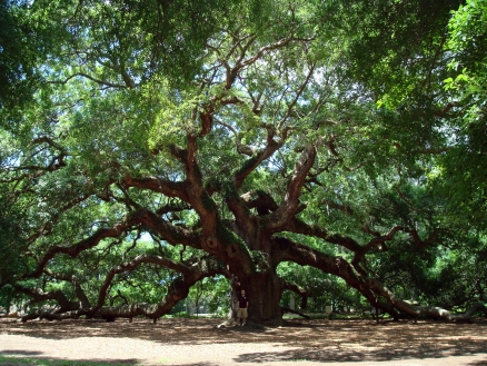
Oaks are intricately tied to the human history of Sonoma County, California. The impressive size of individual trees, and the extent and beauty of the lowland groves are common themes in our county’s historical records. Early writers often compared the valleys where oaks grew to a park, with open spaces between the trees and little understory . This is a testament to the natural vigor of the trees themselves, and to the stewardship of native peoples, who had been tending the land here for thousands of years.
Contents
Quotations from early California settlers
- “We passed through an extremely large roblar (trees very tall and thick) . . . running 3 leagues Mileseast to west, and a league and a half Miles north to south” -- Jose Altimira, founder of the Sonoma Mission, describing Sonoma Valley in 1823.
- “the valleys are . . . sprinkled with oak trees, and it seems ever as if we were about to enter a forest which we never reach, for in the distance the oaks, though really far apart, appear to grow in dark and heavy masses” -- Frank Marryat, describing Sonoma Valley in 1850.
Oak landscape as first recorded
The Spanish term “roblar,” commonly used in Mexican California, is not really conveyed by the English words “forest,” or “grove.” An “oak-dominated landscape” is probably close, if we imagine a place on the floor of a valley where oaks are prominent among a mosaic of grasslands, wetlands, and riparian corridors (see map on the following page). Within a roblar, oaks grow in varying densities, from savannah to denser woodlands. Historically, the roblars of Sonoma County were likely dominated by Valley oaks (Q. lobata) and their hybrids, though blue, black, Oregon and coast live oaks (Q. douglasii, kelloggii, garryana, and agrifolia) were also part of the mix.
An English settler is said to have named the town of Windsor for the area’s resemblance to the well-kept, oak-studded grounds of Windsor Castle. Indeed, because of their desirability as places to live (shady, relatively flat, and not too wet) many Sonoma County towns probably mark the site of a roblar. The Wappo called the Santa Rosa area wici-lo-homa, or ‘meadowlark woods,’ suggesting a mix of open meadows and trees. Sonoma, Petaluma, Cloverdale, Healdsburg, and Cotati all occupy soils where significant numbers of heritage oaks are still found. A combination of natural and human forces had shaped the landscape that greeted 19th century settlers.
In the valleys and other relatively level areas, oak distribution was influenced by several interrelated factors, including: soil type, depth to summer water, and human management. A third of heritage oaks (> 42”diameter and estimated to be >170 years old) in Sonoma Valley are found on just two soil types, and four additional soils support another third of these trees (out of a total of 49 soil types)* Cooper noted that “valley oaks achieve their best development where the water table is 10 – 20 feet below the surface, or where roots can easily penetrate more deeply.” Such conditions are common on alluvial fans, which spread from the mouths of canyons over valley floors. In contrast, where a high water table created seasonal and perennial wetlands, oaks were absent, though they could be found on adjacent sites just a few feet higher. The use of fire as a management tool by Sonoma County’s native peoples is probably largely responsible for the “park-like” appearance of the landscape. Intentional burning, at intervals of a few years, reduced underbrush, restricted the survival of seedlings, recycled nutrients, and controlled insects which prey on oaks. This contributed to the vigor and open spacing of the trees, as Marryat describes. Sonoma Valley c. 1800, showing the mosaic of habitats within the roblar described by Altimira and Marryat (Sonoma Plaza included for reference).
Like the valleys, oaks in the uplands were part of a mosaic of vegetation cover types. In the Mayacamas Mountains, at modern-day Pepperwood Preserve, early surveyors recorded a complex mix of oaks, grassland, and chaparral (Redwood, douglas fir, madrone, and bay were present but uncommon). The oaks were listed as “white,” “black,” and “live” (probably including Q. garryana, douglasii, kelloggii, agrifoli and several hybrids; possibly a few Q. lobata and wislizenii as well). Leather oak (Q. durata), grew among the chaparral and areas of serpentine soil. In the uplands, aspect had a greater role than soil type as a controlling factor. For example, there are heritage coast live oaks (>200 years old) on Sonoma Mountain growing just a few hundred yards from a huge, old-growth redwood. Though all are on the same type of soil, the redwood is in a north-facing depression, while the oaks occupy a southeast facing knoll.
Early changes to the oak landscape
Since Mexican and American settlement began nearly two centuries ago, fire suppression, woodcutting, changes to drainage patterns, grazing, and development of houses, roads and other infrastructure, have affected oak distribution. In some places, these activities have reduced or eliminated the large oaks that are a signature feature of our county’s landscape. In other areas, oaks are colonizing places they could not have grown in the past, such as drained wetlands and the margins of drainage ditches. Fire suppression allows more oaks, and other more shade-tolerant species, to survive the seedling stage, though the brushy and overgrown woodland that often results produces less vigorous trees and an ever-increasing risk of wildfire.
Given the vast changes to Sonoma County described above and the growing impacts of climate change, the historical distribution of oaks is not a perfect blueprint for the future. Nevertheless, it can provide a valuable guide for identifying areas with high potential for preservation and restoration, and the vision of what a healthy ecosystem, with oaks as a vital part, might look like. *one-third of surveyed heritage oaks in Sonoma Valley grow on Los Robles Gravelly Clay Loam and Tuscan Cobbly Clay Loam; another third grow on: Huichica Loam, Lariger Loam, Red Hill Clay Loam, and Zamora Silty Clay Loam.
References
- Altimira, Jose. 1823. Diario de la expedicion verificada con objecto de reconocer terrnos para la nueva planta de la Mision de Nuestro Padre San Francisco principiada le dia 25 de Junio de 1823. Handwritten manuscript at Bancroft Library, University of California Berkeley. Translation by Arthur Dawson.
- Barnhart, Stephen J., Joe R. McBride, and Peter Warner. 1996. "Invasion of Northern Oak Woodlands by Pseudotsuga menziesii (Mirb.) Franco in the Sonoma Mountains of California." Madrono 43(1):28-45.
- Evett, Rand R. and James W. Bartolome. 2009. "Phytolith Analysis of Grassland Soils at Pepperwood Preserve." Division of Ecosystem Science, Department of Environmental Science, Policy, and Management. University of California, Berkeley. Report for Pepperwood Preserve.
- Best, Catherine, John Thomas Howell, Walter & Irja Knight and Mary Wells. 1996. A Flora of Sonoma County: Manual of the Flowering Plants and Ferns of Sonoma County, California. California Native Plant Society. Sacramento, California.
- Clayborn, Hannah. 2007. “The Healdsburg Plaza.” Hannah Clayborn’s History of Healdsburg website. Accessed April 18, 2011. www.ourhealdsburg.com. Cooper, William S. 1926. "Vegetational Development Upon Alluvial Fans in the Vicinity of Palo Alto, California." Ecology, Vol. VII. No. 1.
- Dawson, Arthur. 2008. "Historical Baseline Study of the Grassy Ridges at Pepperwood Preserve." Historical Ecology Program, Sonoma Ecology Center. Report for Pepperwood Preserve. Dawson, Arthur. 2008. "Oaks Through Time: Reconstructing Historical Change in Oak Woodlands." Proceedings of the Sixth Symposium on Oak Woodlands: Today's Challenges, Tomorrow's Opportunities. Vol. 2.. U.S. Department of Agriculture. Albany, California.
- Dawson, Arthur and Christina Sloop. 2010 "Laguna de Santa Rosa Historical Hydrology Project: Headwaters Pilot Study." Joint effort of the Laguna de Santa Rosa Foundation and Sonoma Ecology Center. Report for the Sonoma County Water Agency and the San Francisco Bay Joint Venture. Finny, M.A. and R.E. Martin. 1992. "Short fire intervals recorded by Redwoods at Annadel State Park." Madrono 39 (4): 251 - 262.
- Grossinger, RM, RA Askevold, CJ Striplen, E Brewster, S Pearce, KN Larned, LJ McKee, and JN Collins. 2006. "Coyote Creek Watershed Historical Ecology Study: Historical Condition, Landscape Change, and Restoration Potential in the Eastern Santqa Clara Valley, California." Prepared for the Santa Clara Valley Water District. A Report of SFEI's Historical Ecology, Watersheds, and Wetlands Science Programs, SFEI Publication 426, San Francisco Estuary Institute, Oakland, CA
- Grossinger, Robin M., Charles J. Striplen, Ruth A. Askevold, Elise Brewster, and Erin E. Beller. 2007. "Historical landscape ecology of an urbanized California valley: wetlands and woodlands in the Santa Clara Valley." Landscape Ecology 22:103 - 120.
- Honton, Joe and Anna Warwick Sears. 2006. Enhancing and Caring for the Laguna de Santa Rosa.. Volume II: Resource Set. Laguna de Santa Rosa Foundation. Santa Rosa, California.
- Marryat, Francis Samuel. 1855. Mountains and Molehills: or, Recollections of a Burnt Journal. Harper. New York. Miller, Vernon C. 1972. Soil Survey, Sonoma County California. U.S. Department of Agriculture in cooperation with the University of California Agricultural Experiment Station.