Guana Tolomato Matanzas National Estuarine Research Reserve, Florida
Contents
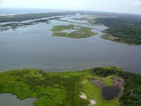
Introduction Guana Tolomato Matanzas Reserve boundary map. (Source: Florida DEP (Guana Tolomato Matanzas National Estuarine Research Reserve, Florida) )
Designated in 1999, the Guana Tolomato Matanzas (GTMNERR) National Estuarine Research Reserve is the Nation’s 25th National Estuarine Research Reserve. The GTMNERR is a federal/state partnership with the Florida Department of Environmental Protection as the state program administrator. The Reserve encompasses approximately 60,000 acres of salt marsh and mangrove tidal wetlands, oyster bars, estuarine lagoons, upland habitat and offshore seas in St. Johns and Flagler Counties. This estuarine ecological system produces a rich abundance of marine life including numerous commercially and recreationally valuable species. GTMNERR contains the northern most extent of mangrove habitat on the east coast of the United States. The coastal waters of the GTMNERR are important calving grounds for the endangered North Atlantic Right Whale. Manatees, wood storks, roseate spoonbills, bald eagles and peregrine falcons find refuge in the GTMNERR.
The Reserve is geographically separated into a northern section where the Tolomato and Guana Rivers mix with the waters of the Atlantic Ocean, and a southern section along the Matanzas River, extending from Moses Creek to south of Pellicer Creek. The reserve is connected to the Atlantic Ocean via the St. Augustine Inlet and the Matanzas Inlet.
The Guana Tolomato Matanzas National Estuarine Research Reserve (GTMNERR) provides opportunities for long-term research, education, and interpretation. The NERR system is one part of the solution for maintaining healthy coastal resources. NERRs research, education, and resource stewardship programs are tools that can help fill gaps in knowledge, and guide decision-making so that our estuaries can sustain multiple uses over the long term.
The GTMNERR is comprised of lands and waters managed by a number of local, state and federal agencies. The protection and management of these natural communities and their valuable functions is shared among the 14 conservation properties and each managing agency. Primary management of these lands is done by the property’s lead agency to fulfill their mission as well as contributing to the proper functioning of the entire GTM estuary. GTMNERR has direct management responsibility for GTMNERR – Guana River, Guana River Marsh Aquatic Preserve and Pellicer Creek Aquatic Preserve.
Research
 (Source: NERRS)
 Data generated from the research programs are used to assess the health of the ecosystem and guide future research efforts. Visiting scientists utilize on-site field station for systems and baseline studies of the plant and animal communities of the reserve. Long-term ecological monitoring efforts of the GTM Reserve include water quality monitoring (physical, chemical and biological), and meteorological and tidal conditions. Geographic Information System (GIS) data and remote sensing are used to analyze natural resources within the reserve and human use of the [[coastal] area].
Exotic Crab in the GTM Reserve
The Guana Tolomato Matanzas National Estuarine Research Reserve is one of nine estuarine research reserves involved in a pilot study to detect exotic (nonindigenous) crabs in local waters. The research has both spatial (where the crab collectors are set up) and seasonal (what time of the year the crabs are collected) components that allow for: 1) early detection of the arrival of exotic species; 2) tracking and predicting the direction and likelihood of invasive range expansion by those exotic species; and 3) monitoring the abundance and diversity of native crabs before, during, and after the invasion process. At the GTM Reserve, crabs are obtained using experimental collecting devices, identified, measured and sexed four times a year (winter, spring, summer and fall) in patchy mud and oyster habitat. Currently, the participating reserves represent comparable estuaries that have been invaded by, or that have not yet been invaded by, particular exotic crabs. The GTM Reserve represents an estuary invaded by at least one species of exotic crab, the Indo-Pacific swimming crab, Charybdis hellerii. As the name suggests, this species is native to the Indo-Pacific region, but has successfully invaded such areas as the Mediterranean, Caribbean and Florida. The Indo-Pacific swimming crab is thought to have been transported to the Caribbean in the ballast water of trans-Atlantic vessels prior to 1987 and the transport of this species is still a concern today. In 1995, the crabs were discovered in the Indian River Lagoon estuarine system and have since been reported by fisherman and researchers in coastal waters of northeast Florida.
With the recognition of potential negative economic, ecological and evolutionary impacts, the introduction of exotic species into estuarine waters is becoming both a local and world-wide concern. Although the threat to our native crab populations is not known at this time, it is important for people most likely to encounter exotic crab species (e.g., commercial fisherman, scientists, schoolteachers, resource managers and conservationists) to become familiar with the Indo-Pacific swimming crab as an initial step towards limiting the extension of its range.
New Weather Station
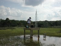 Guana Tolomato Matanzas Reserve weather station. (Source: NERRS)
 Recently, GTM Reserve research staff members have erected and initiated operation of a Campbell Scientific Weather station, the newest addition to the System-Wide Monitoring Program. The 10-foot tall aluminum tower serves as a backbone for the attachment of environmental sensors that record air temperature, relative humidity, barometric pressure, wind speed and direction, and photosynthetically active radiation (the solar energy that plants use in the process of photosynthesis). An additional instrument devised to measure rainfall levels is situated approximately two feet away from the tower. Both the tower and rain gauge are mounted to a five-foot high wooden platform located at the water’s edge within the Princess Place Preserve near the mouth of Pellicer Creek. The location of the weather station is optimal in the sense that it is within the aquatic system that we are striving to understand (in the salt marsh with a distant tree line verses a nearby upland area) and within close proximity to our Pellicer Creek water quality monitoring station.
The addition of the weather station to the System-Wide Monitoring Program is a crucial component in clarifying the natural processes in our estuaries. Once incorporated into water quality data, we will learn how these meteorological parameters affect our waters. Like the water quality instruments, which record at the top and bottom of each hour throughout the year, the majority of the meteorological sensors record data every 15 minutes throughout the year. Some parameters, such as rainfall and photosynthetically active radiation, are totaled on a daily basis. GTM Reserve researchers visit the weather station to download the meteorological data to a palm pilot and clean the sensors to ensure the validity of the data.
Partners and Supporters
The National Oceanic and Atmospheric Administration and the Florida Department of Environmental Protection manage the reserve in partnership.
Local partners include the Florida Fish and Wildlife Conservation Commission, the Florida Park Service, the National Park Service, the St. Johns River Water Management District, the Florida Inland Navigation District, Flagler County, St. Johns County, the Town of Marineland and the City of St. Augustine.
The GTM Reserve Management Advisory Group (MAG) includes 10 citizens appointed by the local legislative delegation to represent the science of estuarine ecology, environmental education and private property owners. MAG meets quarterly to discuss the growth and implementation of the program.
Friends of the GTM Reserve is a private non-profit citizen support organization established to assist in implementing Reserve programs and to coordinate community projects and volunteer efforts.
Further Reading
| Disclaimer: This article is taken wholly from, or contains information that was originally published by, the National Oceanic and Atmospheric Administration. Topic editors and authors for the Encyclopedia of Earth may have edited its content or added new information. The use of information from the National Oceanic and Atmospheric Administration should not be construed as support for or endorsement by that organization for any new information added by EoE personnel, or for any editing of the original content. |