Giant's Causeway and Causeway Coast, United Kingdom
| Topics: |
Contents
- 1 Geographical Location
- 2 Date and History of Establishment
- 3 Area
- 4 Land Tenure
- 5 Altitude
- 6 Physical Features
- 7 Climate
- 8 Vegetation
- 9 Fauna
- 10 Cultural Heritage
- 11 Local Human Population
- 12 Visitors and Visitor Facilities
- 13 Scientific Research and Facilities
- 14 Conservation Value
- 15 Conservation Management
- 16 IUCN Management Category
- 17 Further Reading
Geographical Location
Giant's Causeway and Causeway Coast (55°15'N, 6°31'W) is a World Heritage Site which lies on the Causeway Coast between Causeway Head and Benbane Head, on the north coast of County Antrim, Northern Ireland. 55°15'N, 6°31'W. Irish Grid Reference C947 447.
Date and History of Establishment
- National Trust took over ownership in 1961.
- Inscribed on the World Heritage List in 1986.
Area
 Giant's Causeway, Northern Ireland (Source: Duke University)
 70 hectares (ha) (of cliffs and foreshore). This does not include the area of the car park, hotel and visitor facilities which are included in the nominated site.
Land Tenure
Some 13 ha were bequeathed in 1961 by its then owner Sir McNaghten to the National Trust and further purchases of freehold and leasehold land were carried out with finance from the Ulster Land Fund. The National Trust now own 70 ha of the cliffs and foreshore, whilst the area of the car park and visitor center is owned by the Moyle District Council. There is also a privately owned hotel. Small sections of the site (containing parts of the cliff top path) are on the private property of a number of individuals.
Altitude
Sea level to 100 meters (m).
Physical Features
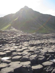
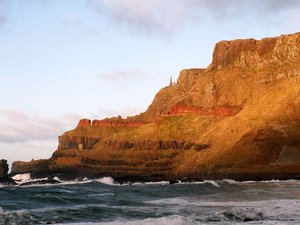 Giant's Causeway, Northern Ireland (Source: Ferrum College)
 The Causeway Coast has an unparalleled display of geological formations representing volcanic activity during the Early Tertiary Period some 50-60 million years ago. Tertiary lavas of the Antrim Plateau, covering some 3,800 square kilometers (km2), represent the largest remaining lava plateau in Europe. The 6 km stretch of [[coast]line] comprises a series of headlands and bays, the former consisting of resistant lavas. The average height of the cliffs is 100 m. They have a stepped appearance due to the succession of five or six lava flows through geological time. These geological succession during the Tertiary period, consists of: the Lower Basalts, where about six of the eleven lava flows are 67 m thick and are exposed between Plaiskin Head and Benbane Head; the Interbasaltic Bed which are exposed along extensive sections of the cliffs east of Giant's Causeway; and the Middle Basalts, which are thick flows ranging from 30 m to over 150 m. Specific sites of interest include the Giant's Causeway itself (a sea level promontory of almost entirely regular polygonal columns averaging 45 centimeters (cm) in diameter and numbering approximately 40,000 columns); the Giant's Organ (about sixty 12 m high regular columns; Chimney Tops (a number of columns separated from the cliffs by erosion); and Hamilton's Seat (a view point). The coastline is also cut through by olivine and tholeiite dykes, a good example of which can be seen at Roveran Valley Head. Exposure of these columns, in perfect horizontal sections at such a scale creating a pavement, is considered a unique combination of features.
Climate
Experiences a temperate Atlantic climate.
Vegetation
Over 200 plant species representing a range of habitats covering seashore, cliff, scree, grassland, scrub, heathland and marsh are present. Localized species of note include red broomrape Orobanche alba, sea spleenwort Asplenium marinum and oyster plant Mertemsia maritima.
Fauna
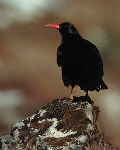 Red-billed Chough Pyrrhocorax pyrrhocorax (Source: Eaglenest Biodiversity Project)
The site is regarded by the Royal Society for the Protection of Birds as one of regional importance within the United Kingdom based on the number of breeding species. Over 50 resident and 30 migrant species have been recorded and include one pair of breeding chough Pyrrhocorax pyrrhocorax and peregrine falcon Falco peregrinus.
Cultural Heritage
The wreck site of the Armada gallesass "Gerona" in Port-na-Spaniagh, below the isolated columns known as the "Chimneys", is of considerable cultural importance. The sub-littoral area is a protected nautical archaeological site, and the treasures and other Armada artifacts recovered by Robert Stenuit and his team between 1967 and 1969 are conserved in the Ulster Museum, Belfast. This collection is a major part of all known recovered Armada artifacts.
The Giant's Causeway featured in the 18th Century geological controversies on the origins of basalts. There is an interesting cultural heritage associated with place names, and other local history such as the kelp (seaweed) and fisheries (Fisheries and aquaculture) exploitation carried out by local communities, documented mainly in the 18th to mid-20th centuries.
Local Human Population
The site is uninhabited now, although several small settlements exist immediately inland of the Causeway cliffs. In the 19th century, and up to the acquisition of the site in 1961 by the National Trust, many temporary commercial stalls and huts were either owned or managed by local people for tourists and visitors. A house occupied by a custodian appointed locally to oversee these activities, was located adjacent to the Giant's Causeway.
Visitors and Visitor Facilities
The Causeway is Northern Ireland's most popular tourist attraction with more than 350,000 visitors annually, over half from overseas. In 1883, the first hydro-electric tramway in the world was opened and by 1887 it was extended to the Causeway Head, where two hotels and numbers of guest houses were built. The site figured frequently in 19th century guidebooks and up and till 1961, the area was heavily commercialized. Visitor facilities include car parks and a visitor center which was opened in 1986 and is located at Causeway Head. Public access to the coast is managed by a system of footpaths. The site is annually visited by geology students on field courses, and over 6,000 schoolchildren.
Scientific Research and Facilities
During the last 300 years, the site has been the object of intense study as is evident by the wealth of scientific literature. It was first reported in 1693 and during the 18th century, was central to the debate concerning the origins of igneous rocks. In 1771, Desmarest concluded the Causeway was a lava flow whilst in 1786, Hamilton produced the first detailed analysis. The work of Tomkeieff and Patterson provided descriptions, interpretations and the correct sequence of the lava flows. The former, most notably, proposed descriptive terms for the Causeway jointing which have been internationally adopted for the description of columnar basalts. Biological surveys have been carried out by the National Trust (1985 and 1992).
Conservation Value
The Causeway itself is a unique feature illustrating the geological activity of successive lava flows and interbasaltic beds. Interpretation of this succession has resulted in a detailed analysis of Tertiary events in the North Atlantic. The scientific research carried out on the site has made an important contribution to petrogenesis over a period of nearly 300 years, marking it as a site of great international significance in the history of earth science.
Conservation Management
The majority of property is owned by the National Trust, and in accordance with the National Trust Act 1907 and the National Trust Act (Northern Ireland) 1946, the area is preserved inalienably. The site lies entirely within the Causeway Coast Area of Outstanding Natural Beauty (AONB) and is further protected in planning by its earlier designation as an Area of Scientific Interest (ASI) and an Area of Special Control (ASC). The site has been a national nature reserve since 1987, and negotiations with individual land owners concerning public access to parts of their properties continues. The agencies involved in management and conservation are the National Trust, Moyle District Council, and the Department of the Environment for Northern Ireland (responsible for the provision of scientific advise and liaison) between whom there is a high level of cooperation. The National Trust manages the site in the context of its Giant's Causeway NNR Mangament Plan, Giant's Causeway Maintenance Plan (1994), Causeway Coast Paths Visitor Management Strategy (1994) and the Causeway Coast Paths Management and Interpretive Plan (1995). These provide policy and guidelines for all aspects of environment and visitor management. The National Trust management aims are to maintain the natural quality of the site; maintain public access by means of purchase and lease of property; maintenance of public footpaths and the creation of new ones; the removal (after negotiations with leases and owners) of all unsightly buildings and intrusions on the landscape; the conservation of the fauna and flora and education of the public. The work includes the maintenance of the 15 km of footpaths (which are continuously eroded and need constant safety work), the provision of interpretative material, a minibus service for elderly/disabled visitors and general guidance services.
Management Constraints
The columnar basalt formations of the Giant's Causeway are not easily damaged by natural forces. In the 18th and 19th centuries, the Causeway Stones were occasionally removed for ornamental use, whilst the zeolite and calcite crystals of the vesicles, in the Lower Basalt, were removed in large quantities by visitors and were sold as souvenirs by guides.
Staff
The National Trust employees approximately 12 staff on a permanent basis, and 15 on a seasonal one. In addition, there are some 10 volunteer guides.
Budget
National Trust recurring budget for the 1995-96 financial year is approximately £150,000. This includes grant-aid for access and visitor management from the Department of the Environment and the European Union (EU), and training and employment for Action for community Employment workers from the Department of Economic Development. Additional grant-aid is available, though, for land acquisition, access and nature conservation.
IUCN Management Category
- IV (Habitat/Species Management Area)
- Natural World Heritage Site - Criteria i, iii
Further Reading
- Anon. (1985). Giant's Causeway Natural Site Nomination. Northern Ireland Nomination Prepared for the Department of the Environment for Northern Ireland Conservation Branch.
- Anon. (1991). National vegetation classification: Giant's Causeway. University of Lancaster. (Reports and Maps).
- National Trust (in prep.). Giant's Causeway National Nature Reserve Managament Plan 1995-1999. National Trust, Cirencester.
- National Trust (1992). Biological Surveys; Giant's Causeway. National Trust, Cirencester.
- National Trust (1994). Giant's Causeway Maintenance Plan. National Trust, Cirencester.
- National Trust (1994). Causeway Coast Paths Visitor Management Strategy. National Trust, Cirencester.
- National Trust (1995). Causeway Coast Paths Management and Interpretive Plan. National Trust, Cirencester.
- Watson, P.S. (1992). The Giant's Causeway - A Remnant of Chaos. HMSO. ISBN: 0337083002
- Watson, P.S. (1995). Romancing the Stone: The Giant's Causeway and the National Trust. Causeway: Cultural Traditions Journal. Spring 1995. Pp 38-42.
- Wilson, H.E. and Manning, P.I. (1978). Geology of the Causeway Coast. Geological Survey of Northern Ireland. Two volumes. HMSO. ISBN: 0337060940
| Disclaimer: This article is taken wholly from, or contains information that was originally published by, the United Nations Environment Programme-World Conservation Monitoring Centre (UNEP-WCMC). Topic editors and authors for the Encyclopedia of Earth may have edited its content or added new information. The use of information from the United Nations Environment Programme-World Conservation Monitoring Centre (UNEP-WCMC) should not be construed as support for or endorsement by that organization for any new information added by EoE personnel, or for any editing of the original content. |