Ecoregions of Tennessee (EPA)
| Topics: |
 Ecoregions of Tennessee
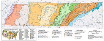
 Ecoregions denote areas of general similarity in ecosystems and in the type, quality, and quantity of environmental resources; they are designed to serve as a spatial framework for the research, assessment, management, and monitoring of ecosystems and ecosystem components. Ecoregions are directly applicable to the immediate needs of state agencies, such as the Tennessee Department of Environment and Conservation (TDEC), for selecting regional stream reference sites and identifying high-quality waters, developing ecoregion-specific chemical and biological water quality criteria and standards, and augmenting TDEC’s watershed management approach. Ecoregion frameworks are also relevant to integrated ecosystem management, an ultimate goal of most federal and state resource management agencies.
The approach used to compile this map is based on the premise that ecological regions can be identified through the analysis of the patterns and the composition of biotic and abiotic phenomena that affect or reflect differences in ecosystem quality and integrity (Wiken 1986; Omernik 1987, 1995). These phenomena include geology, physiography, vegetation, climate, soils, land use, wildlife, and hydrology. The relative importance of each characteristic varies from one ecological region to another regardless of the hierarchical level. A Roman numeral hierarchical scheme has been adopted for different levels of ecological regions. Level I (Ecoregions of Tennessee (EPA)) is the coarsest level, dividing North America (Ecoregions of North America (CEC)) into 15 ecological regions, with Level II (Ecoregions of Tennessee (EPA)) dividing the continent into 52 regions. At level III, the continental United States contains 99 regions (United States Environmental Protection Agency [USEPA] 1997). Level IV (Ecoregions of Tennessee (EPA)) is a further subdivision of Level III (Ecoregions of Tennessee (EPA)) ecoregions. Explanations of the methods used to define USEPA’s ecoregions are given in Omernik (1995), Griffith et al. (1994, 1997), and Gallant et al. (1989).
This level III and IV ecoregion map was compiled at a scale of 1:250,000; it depicts revisions and subdivisions of earlier level III ecoregions that were originally compiled at a smaller scale (USEPA 1996; Omernik 1987). The poster is part of a collaborative project primarily between the USEPA National Health and Environmental Effects Research Laboratory - Corvallis, OR., and TDEC’s Division of Water Pollution Control. Collaboration and consultation also occurred with the United States Department of Agriculture - Natural Resources Conservation Service (NRCS), the United States Department of Agriculture - Forest Service (USFS), USEPA Region IV, and with other State of Tennessee agencies.
This project is associated with an interagency effort to develop a common framework of ecological regions. Reaching that objective requires recognition of the differences in the conceptual approaches and mapping methodologies that have been used to develop the most commonly used existing ecoregion-type frameworks, including those developed by the USFS (Bailey et al. 1994), the USEPA (Omernik 1987, 1995), and the NRCS (U.S. Department of Agriculture 1981). As each of these frameworks is further developed, the differences between them lessen. Regional collaborative projects such as this one in Tennessee, where some agreement can be reached among multiple resource management agencies, is a step in the direction of attaining commonality and consistency in ecoregion frameworks for the entire nation.
|
65. Southeastern Plains | |
|
65a. The Blackland Prairie, extending north from Mississippi, is a flat to undulating lowland region covering only a small portion of McNairy County, Tennessee. Although there is some of the Cretaceous-age chalk, marl, and calcareous clay that characterizes the region in Mississippi and Alabama, the northern extent of the Blackland Prairie in Tennessee is not distinct. To the south, the natural vegetation had dominant trees of sweetgum, post oak, and red cedar, along with patches of bluestem prairie. Today, the area is mostly in cropland and pasture, with small patches of mixed hardwoods. |
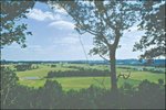 View of Ecoregion 65e’s rolling plains and hills from Natchez Trace State Park and Forest. View of Ecoregion 65e’s rolling plains and hills from Natchez Trace State Park and Forest. 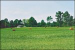 Pasture with some cropland is common on the better-drained land of the Flatwoods/Alluvial Prairie Margins (65b). Pasture with some cropland is common on the better-drained land of the Flatwoods/Alluvial Prairie Margins (65b). 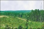 Clearcut on commercial forest land in Ecoregion 65e. Clearcut on commercial forest land in Ecoregion 65e.  The Tennessee River is impounded by Pickwick Landing Dam in the Transition Hills (65j). The Tennessee River is impounded by Pickwick Landing Dam in the Transition Hills (65j). 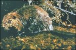 Beaver are common in Ecoregion 65 and are increasing in numbers in many of Tennessee’s ecoregions. Beaver are common in Ecoregion 65 and are increasing in numbers in many of Tennessee’s ecoregions. |
|
66. Blue Ridge Mountains | |
|
66d. The Southern Igneous Ridges and Mountains occur in Tennessee’s northeastern Blue Ridge near the North Carolina border, primarily on Precambrian-age igneous and high-grade metamorphic rocks. The typical crystalline rock types include granite, gneiss, schist, and metavolcanics, covered by well-drained, acidic brown loamy soils. Elevations of this rough, dissected region range from 2000-6200 feet, with Roan Mountain reaching 6286 feet. Although there are a few small areas of pasture and apple orchards, the region is mostly forested; Appalachian oak and northern hardwoods forests predominate. |
 Cades Cove in Ecoregion 66f and the Great Smoky Mountains of Ecoregion 66g. Cades Cove in Ecoregion 66f and the Great Smoky Mountains of Ecoregion 66g.  Roan Mountain rhododendrons in the Southern Igneous Ridges and Mountains (66d). Roan Mountain rhododendrons in the Southern Igneous Ridges and Mountains (66d).  Blue Ridge streams have a distinct fish fauna, with some containing brook trout, the only salmonid native to Tennessee. Blue Ridge streams have a distinct fish fauna, with some containing brook trout, the only salmonid native to Tennessee.  The mixed forests of Chilhowee Mountain in Ecoregion 66e have a history of disturbance by Indians, settlers, loggers, and fire. The mixed forests of Chilhowee Mountain in Ecoregion 66e have a history of disturbance by Indians, settlers, loggers, and fire.  Most all of Tennessee’s black bears are found in the Blue Ridge Mountains (66). Most all of Tennessee’s black bears are found in the Blue Ridge Mountains (66). |
| 67. Ridge and Valley Also known as the Great Valley of East Tennessee, this is a relatively low-lying region between the Blue Ridge Mountains to the east and the Cumberland Plateau on the west. As a result of extreme folding and faulting events, the roughly parallel ridges and valleys come in a variety of widths, heights, and geologic materials, including limestone, dolomite, shale, siltstone, sandstone, chert, mudstone, and marble. Springs and caves are relatively numerous. Present-day forests cover about 50% of the region. The ecoregion has great aquatic habitat diversity in Tennessee and supports a diverse fish fauna rivaled only by that of the Highland Rim. | |
| 67f. The Southern Limestone/Dolomite Valleys and Low Rolling Hills form a heterogeneous region composed predominantly of limestone and cherty dolomite. Landforms are mostly low rolling ridges and valleys, and the soils vary in their productivity. Landcover includes intensive agriculture, urban and industrial, or areas of thick forest. White oak forests, bottomland oak forests, and sycamore-ash-elm riparian forests are the common forest types, and grassland barrens intermixed with cedar-pine glades also occur here. |
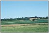
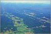 Landscape patterns of Ecoregions 67f and 67i include forested ridges, low rolling hills, and agricultural valleys. Landscape patterns of Ecoregions 67f and 67i include forested ridges, low rolling hills, and agricultural valleys. 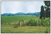 Livestock, dairy, hay, corn, small grain, vegetables, and tobacco are the typical farm products of the Ridge and Valley (67). Livestock, dairy, hay, corn, small grain, vegetables, and tobacco are the typical farm products of the Ridge and Valley (67).  Urban, industrial, and agricultural activities are common in the valleys of Ecoregion 67f. Urban, industrial, and agricultural activities are common in the valleys of Ecoregion 67f.  Free-flowing aquatic habitats have been greatly reduced by impoundments on the Tennessee River and all of its major tributaries. Free-flowing aquatic habitats have been greatly reduced by impoundments on the Tennessee River and all of its major tributaries.  The largest known population of tall larkspur, an endangered plant species associated with cedar barrens of the Ridge and Valley, is found on federal land near Oak Ridge. The largest known population of tall larkspur, an endangered plant species associated with cedar barrens of the Ridge and Valley, is found on federal land near Oak Ridge. |
| 67g. The Southern Shale Valleys consist of lowlands, rolling valleys, and slopes and hilly areas that are dominated by shale materials. The northern areas are associated with Ordovician-age calcareous shale, and the well-drained soils are often slightly acid to neutral. In the south, the shale valleys are associated with Cambrian-age shales that contain some narrow bands of limestone, but the soils tend to be strongly acid. Small farms and rural residences subdivide the land. The steeper slopes are used for pasture or have reverted to brush and forested land, while small fields of hay, corn, tobacco, and garden crops are grown on the foot slopes and bottom land. | |
| 67h. The Southern Sandstone Ridges ecoregion encompasses the major sandstone ridges, but these ridges also have areas of shale and siltstone. The steep, forested ridges have narrow crests, and the soils are typically stony, sandy, and of low fertility. The chemistry of streams flowing down the ridges can vary greatly depending on the geologic material. The higher elevation ridges are in the north, including Wallen Ridge, Powell Mountain, Clinch Mountain and Bays Mountain. White Oak Mountain in the south has some sandstone on the west side, but abundant shale and limestone as well. Grindstone Mountain, capped by the Gizzard Group sandstone, is the only remnant of Pennsylvanianage strata in the Ridge and Valley of Tennessee. | |
| 67i. The Southern Dissected Ridges and Knobs contain more crenulated, broken, or hummocky ridges, compared to the smoother, more sharply pointed sandstone ridges of Ecoregion 67h. Although shale is common, there is a mixture and interbedding of geologic materials. The ridges on the east side of Tennessee’s Ridge and Valley tend to be associated with the Ordovician-age Sevier shale, Athens shale, and Holston and Lenoir limestones. These can include calcareous shale, limestone, siltstone, sandstone, and conglomerate. In the central and western part of Ecoregion 67, the shale ridges are associated with the Cambrian-age Rome Formation: shale and siltstone with beds of sandstone. Chestnut oak forests and pine forests are typical for the higher elevations of the ridges, with areas of white oak, mixed mesophytic forest, and tulip poplar on the lower | |
| 68. Southwestern Appalachians Stretching from Kentucky to Alabama, these open low mountains contain a mosaic of forest and woodland with some cropland and pasture. The eastern boundary of the ecoregion in Tennessee, along the more abrupt escarpment where it meets the Ridge and Valley (67), is relatively smooth and only slightly notched by small eastward flowing stream drainages. The western boundary, next to the Interior Plateau’s Eastern Highland Rim (71g), is more crenulated with a rougher escarpment that is more deeply incised. The mixed mesophytic forest is restricted mostly to the deeper ravines and escarpment slopes, and the upland forests are dominated by mixed oaks with shortleaf pine. | |
| 68a. The Cumberland Plateau’s tablelands and open low mountains are about 1000 feet higher than the Eastern Highland Rim (71g) to the west, and receive slightly more precipitation with cooler annual temperatures than the surrounding lower-elevation ecoregions. The plateau surface is less dissected with lower relief compared to the Cumberland Mountains (69d) or the Plateau Escarpment (68c). Elevations are generally 1200-2000 feet, with the Crab Orchard Mountains reaching over 3000 feet. Pennsylvanianage conglomerate, sandstone, siltstone, and shale is covered by mostly well-drained, acid soils of low fertility. The region is forested, with some agriculture and coal mining activities. |
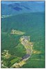
 The Plateau Escarpment (68c) of the Tennessee River Gorge. The Plateau Escarpment (68c) of the Tennessee River Gorge. 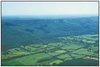 Sequatchie Valley (68b) and Plateau Escarpment (68c). Sequatchie Valley (68b) and Plateau Escarpment (68c). 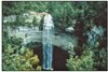 Many waterfalls occur near the boundary of Ecoregions 68a and 68c where softer rocks erode under the sandstone cap. Many waterfalls occur near the boundary of Ecoregions 68a and 68c where softer rocks erode under the sandstone cap. 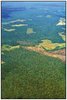 Forest, pasture, and clearcut landscape mosaic of the Cumberland Plateau (68a). Forest, pasture, and clearcut landscape mosaic of the Cumberland Plateau (68a).  The deeper ravines and gorges of Ecoregion 68c provide wet and cool environments that can harbor distinct plant communities. The deeper ravines and gorges of Ecoregion 68c provide wet and cool environments that can harbor distinct plant communities. |
| 68b. The Sequatchie Valley is structurally associated with an anticline, where erosion of broken rock to the south of the Crab Orchard Mountains scooped out the linear valley. The open, rolling, valley floor, 600-1000 feet in elevation, is generally 1000 feet and east valleys of Mississippian to Ordovician-age limestones, dolomites, and shales. Similar to parts of the Ridge and Valley (67), this is an agriculturally productive region, with areas of pasture, hay, soybeans, small grain, corn, and tobacco. | |
| 68c. The Plateau Escarpment is characterized by steep, forested slopes and high velocity, high gradient streams. Local relief is often 1000 feet or more. The geologic strata include Mississippian-age limestone, sandstone, shale, and siltstone, and Pennsylvanian-age shale, siltstone, sandstone, and conglomerate. Streams have cut down into the limestone, but the gorge talus slopes are composed of colluvium with huge angular, slabby blocks of sandstone. Vegetation community types in the ravines and gorges include mixed oak and chestnut oak on the upper slopes, more mesic forests on the middle and lower slopes (beech-tulip poplar, sugar maple-basswood-ash-buckeye), with hemlock along rocky streamsides and river birch along floodplain terraces. | |
| 69. Central Appalachians | |
|
The Central Appalachian ecoregion, stretching from northern Tennessee to central Pennsylvania, is primarily a high, dissected, rugged plateau composed of sandstone, shale, conglomerate, and coal. The rugged terrain, cool climate, and infertile soils limit agriculture, resulting in a mostly forested landcover. The high hills and low mountains are covered by a mixed mesophytic forest with areas of Appalachian oak and northern hardwoods forest. Bituminous coal mines are common, and have caused the siltation and acidification of streams. | |
| 69d. The Cumberland Mountains, in contrast to the sandstone-dominated Cumberland Plateau (68a) to the west and southwest, are more highly dissected, with narrowcrested steep slopes, and younger Pennsylvanian-age shales, sandstones, siltstones, and coal. Narrow, winding valleys separate the mountain ridges, and relief is often 2000 feet. Cross Mountain, west of Lake City, reaches 3534 feet in elevation. Soils are generally well-drained, loamy, and acidic, with low fertility. The natural vegetation is a mixed mesophytic forest, although composition and abundance vary greatly depending on aspect, slope position, and degree of shading from adjacent land masses. Large tracts of land are owned by lumber and coal companies, and there are many areas of stripmining. |
 Coal mining in the Cumberland Mountains (69d). Coal mining in the Cumberland Mountains (69d).  White-tail deer populations have increased in many Tennessee ecoregions in recent decades. White-tail deer populations have increased in many Tennessee ecoregions in recent decades.  The rugged Cumberland Mountains of the Frozen Head State Natural Area also contain 120 species of spring wildflowers. The rugged Cumberland Mountains of the Frozen Head State Natural Area also contain 120 species of spring wildflowers. |
| 71. Interior Plateau The Interior Plateau is a diverse ecoregion extending from southern Indiana and Ohio to northern Alabama. Rock types are distinctly different from the coastal plain sands of western Tennessee ecoregions, and elevations are lower than the Appalachian ecoregions to the east. Mississippian to Ordovician-age limestone, chert, sandstone, siltstone and shale compose the landforms of open hills, irregular plains, and tablelands. The natural vegetation is primarily oak-hickory forest, with some areas of bluestem prairie and cedar glades. The region has the most diverse fish fauna in Tennessee. | |
| 71e. The Western Pennyroyal Karst is a flatter area of irregular plains, with fewer perennial streams, compared to the open hills of the Western Highland Rim (71f). Small sinkholes and depressions are common. The productive soils of this notable agricultural area are formed mostly from a thin loess mantle over residuum of Mississippian-age limestones. Most of the region is cultivated or in pasture; tobacco and livestock are the principal agricultural products, with some corn, soybeans, and small grains. The natural vegetation consisted of oak-hickory forest with mosaics of bluestem prairie. The barrens of Kentucky that extended south into Stewart, Montgomery, and Robertson counties, were once some of the largest natural grasslands in Tennessee. |
 Strip-cropping on Western Pennyroyal Karst (71e) agricultural land. Strip-cropping on Western Pennyroyal Karst (71e) agricultural land.  Tobacco is grown in large areas of 71e, and in smaller plots like this in the more hilly ecoregions of the Interior Plateau (71f, 71h). Tobacco is grown in large areas of 71e, and in smaller plots like this in the more hilly ecoregions of the Interior Plateau (71f, 71h). 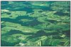 Cropland, pasture, and an extensive ornamental nursery industry are found on the more level terrain of the Eastern Highland Rim (71g). Cropland, pasture, and an extensive ornamental nursery industry are found on the more level terrain of the Eastern Highland Rim (71g). 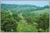 Woodland and pasture on the rolling hills of the Outer Nashville Basin (71h). Woodland and pasture on the rolling hills of the Outer Nashville Basin (71h).  The regions of the Interior Plateau in Tennessee are remnants of a huge geological structure, the Nashville Dome, that fractured and eroded away, leaving a crater-like central basin. The regions of the Interior Plateau in Tennessee are remnants of a huge geological structure, the Nashville Dome, that fractured and eroded away, leaving a crater-like central basin. |
| 71f. The Western Highland Rim is characterized by dissected, rolling terrain of open hills, with elevations of 400-1000 feet. The geologic base of Mississippian-age limestone, chert, and shale is covered by soils that tend to be cherty, acid, and low to moderate in fertility. Streams are characterized by coarse chert gravel and sand substrates with areas of bedrock, moderate gradients, and relatively clear water. The oak-hickory natural vegetation was mostly deforested in the mid to late 1800’s, in conjunction with the iron-ore related mining and smelting of the mineral limonite, but now the region is again heavily forested. Some agriculture occurs on the flatter interfluves and in the stream and river valleys: mostly hay, pasture, and cattle, with some cultivation of corn and tobacco. | |
| 71g. The Eastern Highland Rim has more level terrain than the Western Highland Rim (71f), with landforms characterized as tablelands of moderate relief and irregular plains. Mississippian-age limestone, chert, shale, and dolomite redominate, and karst terrain sinkholes and depressions are especially noticeable between Sparta and McMinnville. Numerous springs and spring-associated fish fauna also typify the region. Natural vegetation for the region is transitional between the oak-hickory type to the west and the mixed mesophytic forests of the Appalachian ecoregions (68, 69) to the east. Bottomland hardwoods forests were once abundant in some areas, although much of the original bottomland forest has been inundated by several large impoundments. Barrens and former prairie areas are now mostly oak thickets or pasture and cropland. | |
| 71h. The Outer Nashville Basin is a more heterogeneous region than the Inner Nashville Basin (71i), with more rolling and hilly topography and slightly higher elevations. The region encompasses most all of the outer areas of the generally non-cherty Ordovician limestone bedrock. The higher hills and knobs are capped by the more cherty Mississippianage formations, and some Devonian-age Chattanooga shale, remnants of the Highland Rim. The region’s limestone rocks and soils are high in phosphorus, and commercial phosphate is mined. Deciduous forest with pasture and cropland are the dominant land covers. Streams are low to moderate gradient, with productive, nutrient-rich waters, resulting in algae, rooted vegetation, and occasionally high densities of fish. The Nashville Basin as a whole has a distinctive fish fauna, notable for fish that avoid the region, as well as those that are present. | |
| 71i. The Inner Nashville Basin is less hilly and lower than the Outer Nashville Basin (71h), outcrops of the Ordovician-age limestone are common, and the generally shallow soils are redder and lower in phosphorus than those of the outer basin. Streams are lower gradient than surrounding regions, often flowing over large expanses of limestone bedrock. The most characteristic hardwoods within the inner basin are a maple-oak-hickoryash association. The limestone cedar glades of Tennessee, a unique mixed grassland/forest cedar glades vegetation type with many endemic species, are located primarily on the limestones of the Inner Nashville Basin. The more xeric, open characteristics and shallow soils of the cedar glades also result in a distinct distribution of amphibian and reptile species. Urban, suburban, and industrial land use in the region is increasing. | |
| 73. Mississippi Alluvial Plain This riverine ecoregion extends from southern Illinois, at the confluence of the Ohio River with the Mississippi River, south to the Gulf of Mexico. It is mostly a flat, broad floodplain with river terraces and levees providing the main elements of relief. Regionally, the soils tend to be poorly drained, although locally some sandy soils are well-drained. Winters are mild and summers are hot, with temperatures and precipitation increasing from north to south. Bottomland deciduous forest vegetation covered the region before clearance for cultivation. | |
| 73a. The Northern Mississippi Alluvial Plain within Tennessee is a relatively flat region of Quaternary alluvial deposits of sand, silt, clay, and gravel. It is bounded distinctly on the east by the Bluff Hills (74a), and on the west by the Mississippi River. Average elevations are 200-300 feet with little relief. Most of the region is in cropland, with some areas of deciduous forest. Soybeans, cotton, corn, sorghum, and vegetables are the main crops. The natural vegetation consists of Southern floodplain forest (oak, tupelo, bald cypress). The two main distinctions in the Tennessee portion of the ecoregion are between areas of loamy, silty, and sandy soils with better drainage, and areas of more clayey soils of poor drainage that may contain wooded swamp-land and oxbow lakes. Waterfowl, raptors, and migratory songbirds are relatively abundant in the region. |
 Reelfoot Lake, created by earthquakes in 1811 and 1812, provides important habitat for fish and birds. Reelfoot Lake, created by earthquakes in 1811 and 1812, provides important habitat for fish and birds.  Bald eagle populations have increased, but are still threatened by habitat loss and environmental contaminants. Bald eagle populations have increased, but are still threatened by habitat loss and environmental contaminants. 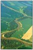 Fields and forest along the lower Forked Deer River. Fields and forest along the lower Forked Deer River.  The banded water snake in Tennessee is found primarily in the Mississippi Alluvial Plain (73). The banded water snake in Tennessee is found primarily in the Mississippi Alluvial Plain (73).  Barges on the meandering Mississippi River. Barges on the meandering Mississippi River. |
| 74. Mississippi Valley Loess Plains This ecoregion stretches from near the Ohio River in western Kentucky to Louisiana. It consists primarily of irregular plains, with oak-hickory and oak-hickory-pine natural vegetation. Thick loess tends to be the distinguishing characteristic. With flatter topography than the Southeastern Plains (65) to the east, streams tend to have less gradient and more silty substrates. In Tennessee, agriculture is the dominant land use. | |
| 74a. The Bluff Hills consist of sand, clay, silt, and lignite, and are capped by loess greater than 60 feet deep. The disjunct region in Tennessee encompasses those thick loess areas that are generally the steepest, most dissected, and forested. The carved loess has a mosaic of microenvironments, including dry slopes and ridges, moist slopes, ravines, bottomland areas, and small cypress swamps. While oak-hickory is the general forest type, some of the undisturbed bluff vegetation is rich in mesophytes, such as beech and sugar maple, with similarities to hardwood forests of eastern Tennessee. Smaller streams of the Bluff Hills have localized reaches of increased gradient and small areas of gravel substrate that create aquatic habitats that are distinct from those of the Loess Plains (74b) to the east. Unique, isolated fish assemblages more typical of upland habitats can be |
 The Bluff Hills (74a) form a distinct boundary where they meet the level cropland of the Mississippi Alluvial Plain (73). The Bluff Hills (74a) form a distinct boundary where they meet the level cropland of the Mississippi Alluvial Plain (73). 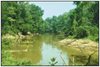 Most streams in 74b have been channelized. The Hatchie River remains relatively unaltered, and its bottomland forest provides important wildlife habitat. Most streams in 74b have been channelized. The Hatchie River remains relatively unaltered, and its bottomland forest provides important wildlife habitat.  Rolling pasture land occurs in some eastern areas of the Bluff Hills (74a). Rolling pasture land occurs in some eastern areas of the Bluff Hills (74a).  Agricultural landscape of the Loess Plains (74b) near Dyer. Agricultural landscape of the Loess Plains (74b) near Dyer. |
| 74b. The Loess Plains are gently rolling, irregular plains, 250-500 feet in elevation, with loess up to 50 feet thick. The region is a productive agricultural area of soybeans, cotton, corn, milo, and sorghum crops, along with livestock and poultry. Soil erosion can be a problem on the steeper, upland Alfisol soils; bottom soils are mostly silty Entisols. Oakhickory and southern flooplain forests are the natural vegetation types, although most of the forest cover has been removed for cropland. Some less-disturbed bottomland forest and cypress-gum swamp habitats still remain. Several large river systems with wide floodplains, the Obion, Forked Deer, Hatchie, Loosahatchie, and Wolf, cross the region. Streams are lowgradient and murky with silt and sand bottoms, and most have been channelized. | |
Notes
- The full, original version of this entry is located here: http://www.epa.gov/wed/pages/ecoregions/tn_eco.htm. That description contains additional maps, as well as information on the physiography, geology, soil, potential natural vegetation, and the land use and land cover of the ecoregion.
- PRINCIPAL AUTHORS: Glenn Griffith (USEPA), James Omernik (USEPA) and Sandra Azevedo (OAO Corporation).
- COLLABORATORS AND CONTRIBUTORS: John Jenkins (NRCS), Richard Livingston (NRCS), James Keys (USFS); Phil Stewart (TDEC), Greg Russell (TDEC), Alan Woods (Dynamac Corporation), Joy Broach (TDEC), Linda Cartwright (TDEC), Debbie Arnwine (Tennessee Department of Health), and Thomas Loveland (USGS).
Literature Cited:
- Bailey, R.G., Avers, P.E., King, T., and McNab, W.H., eds., 1994, Ecoregions and subregions of the United States (map) (supplementary table of map unit descriptions compiled and edited by McNab, W.H. and Bailey, R.G.): Washington, D.C., U.S. Department of Agriculture - Forest Service, scale 1:7,500,000.
- Gallant, A.L., Whittier, T.R., Larsen, D.P., Omernik, J.M., and Hughes, R.M., 1989, Regionalization as a tool for managing environmental resources: Corvallis, Oregon, U.S.Environmental Protection Agency EPA/600/3-89/060, 152 p.
- Griffith, G.E., Omernik, J.M., Wilton, T.F., and Pierson, S.M., 1994, Ecoregions and subregions of Iowa - a framework for water quality assessment and management: The Journal of the Iowa Academy of Science, v. 101, no. 1, p. 5-13.
- Griffith, G.E., Omernik, J.M., and Azevedo, S.H., 1997, Ecoregions of Tennessee: Corvallis, Oregon, U.S. Environmental Protection Agency EPA/600R-97/022, 51 p.
- Omernik, J.M., 1987, Ecoregions of the conterminous United States (map supplement): Annals of the Association of American Geographers, v. 77, no. 1, p. 118-125, scale 1:7,500,000.
- Omernik, J.M., 1995, Ecoregions - a framework for environmental management, in Davis, W.S. and Simon, T.P., eds., Biological assessment and criteria - tools for water resource planning and decision making: Boca Raton, Florida, Lewis Publishers, p. 49-62.
- U.S. Department of Agriculture - Soil Conservation Service, 1981, Land resource regions and major land resource areas of the United States: Agriculture Handbook 296, 156 p.
- U.S. Environmental Protection Agency, 1997, Level III ecoregions of the continental United States (revision of Omernik, 1987): Corvallis, Oregon, U.S. Environmental Protection Agency - National Health and Environmental Effects Research Laboratory Map M-1, various scales.
- Wiken, E., 1986, Terrestrial ecozones of Canada: Ottawa, Environment Canada, Ecological Land Classification Series no. 19, 26 p.