Ecoregions of Alabama and Georgia (EPA)
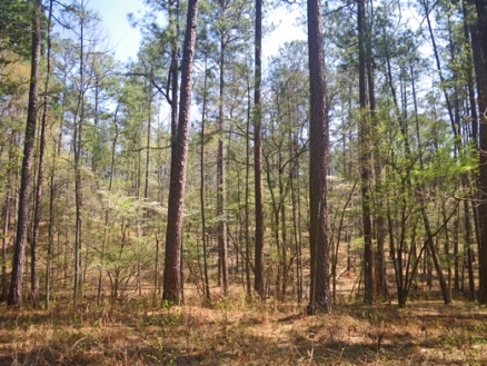
Southern pine plains and hills ecoregion, southern Georgia. Source: C.Michael Hogan
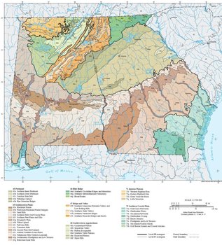 Ecoregions of Alabama and Georgia.
 Ecoregions denote areas of general similarity in ecosystems and in the type, quality, and quantity of environmental resources. They are designed to serve as a spatial framework for the research, assessment, management, and monitoring of ecosystems and ecosystem components. Ecoregions are directly applicable to the immediate needs of state agencies, including the development of biological criteria and water quality standards and the establishment of management goals for nonpoint-source pollution. They are also relevant to integrated ecosystem management, an ultimate goal of many federal and state resource management agencies.
The approach used to compile this map is based on the premise that ecological regions can be identified through the analysis of the spatial patterns and the composition of biotic and abiotic phenomena that affect or reflect differences in ecosystem quality and integrity (Wiken 1986; Omernik 1987, 1995). These phenomena include geology, physiography, vegetation, climate, soils, land use, wildlife, and hydrology. The relative importance of each characteristic varies from one ecological region to another regardless of the hierarchical level. A Roman numeral hierarchical scheme has been adopted for different levels of ecological regions. Level I (Ecoregions of Alabama and Georgia (EPA)) is the coarsest level, dividing North America into 15 ecological regions. Level II (Ecoregions of Alabama and Georgia (EPA)) divides the continent into 52 regions (Commission for Environmental Cooperation Working Group 1997). At Level III (Ecoregions of Alabama and Georgia (EPA)), the continental United States contains 104 ecoregions and the conterminous United States has 84 ecoregions (United States Environmental Protection Agency [USEPA] 2000). Level IV (Ecoregions of Alabama and Georgia (EPA)) is a further subdivision of level III ecoregions. Explanations of the methods used to define the USEPA’s ecoregions are given in Omernik (1995), Omernik and others (2000), Griffith and others (1994), and Gallant and others (1989).
Alabama and Georgia contain barrier islands and coastal lowlands, large river floodplain forests, rolling plains and plateaus, forested mountains, and a variety of aquatic habitats. Ecological and biological diversity is enormous. There are 7 level III ecoregions and 44 level IV ecoregions in Alabama and Georgia and most continue into ecologically similar parts of adjacent states.
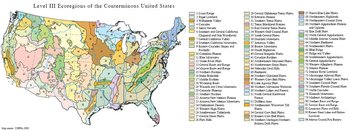 Level III Ecoregions of the Conterminous United States. (Map source: USEPA, 2000)
 The level III and IV ecoregion map on this poster was compiled at a scale of 1:250,000 and depicts revisions and subdivisions of earlier level III ecoregions that were originally compiled at a smaller scale (USEPA 2000; Omernik 1987). This poster is part of a collaborative project primarily between USEPA Region IV, USEPA National Health and Environmental Effects Research Laboratory (Corvallis, Oregon), Alabama Department of Environmental Management (ADEM), Georgia Department of Natural Resources (GA DNR), and the United States Department of Agriculture-Natural Resources Conservation Service (NRCS). Collaboration and consultation also occurred with the United States Department of Agriculture-Forest Service (USFS), United States Department of the Interior-Geological Survey (USGS)-Earth Resources Observation Systems (EROS) Data Center, and with other State of Alabama and State of Georgia agencies.
The project is associated with an interagency effort to develop a common framework of ecological regions. Reaching that objective requires recognition of the differences in the conceptual approaches and mapping methodologies applied to develop the most common ecoregion-type frameworks, including those developed by the USFS (Bailey and others, 1994), the USEPA (Omernik 1987, 1995), and the NRCS (U.S. Department of Agriculture-Soil Conservation Service, 1981). As each of these frameworks is further refined, their differences are becoming less discernible. Regional collaborative projects such as this one in Alabama and Georgia, where some agreement has been reached among multiple resource management agencies, is a step toward attaining consensus and consistency in ecoregion frameworks for the entire nation.
|
45. Piedmont | |
|
45a. The Southern Inner Piedmont is mostly higher in elevation with more relief than 45b, but is generally lower and has less relief and contains different rocks and soils than 45d. The rolling to hilly, well-dissected upland contains mostly schist, gneiss, and granite bedrock. In the western portion, west of Atlanta and into Alabama, mica schist and micaceous saprolite are typical. To the east, biotite gneiss is more common. The region is now mostly forested, with major forest types of oak-pine and oak-hickory, with less loblolly-shortleaf pine forest than 45b. Open areas are mostly in pasture, although there are some small areas of cropland. Hay, cattle, and poultry are the main agricultural products. In Georgia, urban/suburban land cover has increased greatly within this ecoregion over the past twenty years. |
 Several major land cover transformations have occurred in the Piedmont over the past 200 years, from forest to farm, back to forest, and now in many areas, spreading urban- and suburbanization. (Photo: Joe and Monica Cook) Several major land cover transformations have occurred in the Piedmont over the past 200 years, from forest to farm, back to forest, and now in many areas, spreading urban- and suburbanization. (Photo: Joe and Monica Cook)  Endangered Shoals Spiderlilies (Hymenocallis coronaria) occur in some of the major streams of 45b, often near the Fall Line. They need flowing, oxygenated water and rocky shoals, and are threatened by siltation and poaching of the bulbs. (Photo: Joe and Monica Cook) Endangered Shoals Spiderlilies (Hymenocallis coronaria) occur in some of the major streams of 45b, often near the Fall Line. They need flowing, oxygenated water and rocky shoals, and are threatened by siltation and poaching of the bulbs. (Photo: Joe and Monica Cook) |
|
65. Southeastern Plains | |
|
65a. The flat to undulating Blackland Prairie region has distinctive Cretaceous-age chalk, marl, and calcareous clay. The clayey soils tend to shrink and crack when dry and swell when wet. Streams have a high variability in flow and affect some fish species distributions. The natural vegetation had dominant trees of sweetgum, post oak, and red cedar, along with patches of bluestem prairie. Today, the area is mostly cropland and pasture, with small patches of mixed hardwoods. Pond-raised catfish aquaculture has increased in recent years. |
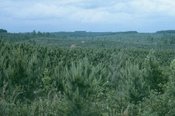 Extensive pine planation on the rolling terrain of the Southeastern Plains and Hills ecoregion (65e) within the Conecuh River basin, Alabama. Extensive pine planation on the rolling terrain of the Southeastern Plains and Hills ecoregion (65e) within the Conecuh River basin, Alabama. 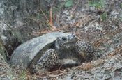 The threatened gopher tortoise is a keystone species found in parts of ecoregion 65 and longleaf pine communities. Many different animal species use the gopher tortoise burrows during various stages of their life cycle. The gopher tortoise population is declining. The threatened gopher tortoise is a keystone species found in parts of ecoregion 65 and longleaf pine communities. Many different animal species use the gopher tortoise burrows during various stages of their life cycle. The gopher tortoise population is declining. 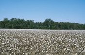 Cotton comprises a large percent of the harvested cropland of ecoregion 65 in Alabama and Georgia. Cotton production in Georgia peaked in the 1910-1920 period, reached a low in the 1970's and early 1980's, and increased greatly in the 1990s. Cotton comprises a large percent of the harvested cropland of ecoregion 65 in Alabama and Georgia. Cotton production in Georgia peaked in the 1910-1920 period, reached a low in the 1970's and early 1980's, and increased greatly in the 1990s. |
|
66. Blue Ridge | |
|
66d. The Southern Crystalline Ridges and Mountains contain the highest and wettest mountains in Georgia. These occur primarily on Precambrian-age igneous and high-grade metamorphic rocks. The common crystalline rock types include gneiss, schist, and quartzite, covered by well-drained, acidic, brownish, loamy soils. Some mafic and ultramafic rocks also occur here, producing more basic soils. Elevations of this rough, dissected region are typically 1800-4000 feet, with Brasstown Bald Mountain, the highest point in Georgia, reaching 4,784 feet. Although there are a few small areas of pasture and apple orchards, the region is mostly forested. |
 The Blue Ridge is part of one of richest temperate broadleaf forests in the world, with a high diversity of flora and fauna. Black bear, whitetail deer, wild boar, turkey, grouse, songbirds, many species of amphibians and reptiles, thousands of species of invertebrates, and a variety of small mammals are found here. (Photo: Ed Jackson, Univ. of GA) The Blue Ridge is part of one of richest temperate broadleaf forests in the world, with a high diversity of flora and fauna. Black bear, whitetail deer, wild boar, turkey, grouse, songbirds, many species of amphibians and reptiles, thousands of species of invertebrates, and a variety of small mammals are found here. (Photo: Ed Jackson, Univ. of GA) |
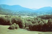
| 67. Ridge and Valley Sometimes called the Great Valley in Georgia or the Coosa Valley in Alabama, this is a relatively low-lying region between the Blue Ridge (66) to the east and the Southwestern Appalachians (68) on the west. As a result of extreme folding and faulting events, the roughly parallel ridges and valleys come in a variety of widths, heights, and geologic materials, including limestone, dolomite, shale, siltstone, sandstone, chert, mudstone, and marble. Springs and caves are relatively numerous. Land cover is mixed and present-day forests cover about 50% of the region. The ecoregion has great aquatic habitat diversity and supports a diverse fish fauna. | |
|
67f. The Southern Limestone/Dolomite Valleys and Low Rolling Hills form a heterogeneous region composed predominantly of limestone and cherty dolomite. Landforms are mostly undulating valleys and rounded ridges and hills, with many caves and springs. Soils vary in their productivity, and land cover includes oak-hickory and oak-pine forests, pasture, intensive agriculture, and urban and industrial. Along the Coosa River floodplain, biota more typical of coastal plain regions can be found due to the valley and riverine connection to ecoregion 65 in Alabama. |
 Forested ridges, and valleys with pasture and cropland, are typical in many parts of ecoregion 67. Its diverse habitats contain many unique species of terrestrial and aquatic flora and fauna. Forested ridges, and valleys with pasture and cropland, are typical in many parts of ecoregion 67. Its diverse habitats contain many unique species of terrestrial and aquatic flora and fauna. 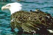 Bald eagles are attracted to fish in the reservoirs of the Bald eagles are attracted to fish in the reservoirs of theRidge and Valley. Eagle populations have increased, but habitat loss and environmental contaminants are still a concern. |
|
68. Southwestern Appalachians | |
|
68a. The Cumberland Plateau’s tablelands are about 1000 feet higher than the Eastern Highland Rim (71g) to the west, and receive slightly more precipitation with cooler annual temperatures than the surrounding lower-elevation ecoregions. Similar to 68d, the plateau surface has less dissection and relief compared to the Plateau Escarpment (68c). Elevations of the region in Alabama are generally 1500-1700 feet. Pennsylvanian-age sandstone, conglomerate, siltstone, and shale is covered by mostly well-drained, acid soils of low fertility. The region is mostly forested or in pasture, with some cropland in the lower elevation section to the south. |
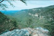 Layers of sandstone, limestone, and shale are exposed on the steep slopes of Cloudland Canyon (Sitton Gulch) in 68c in northwest Georgia. (Photo: Ed Jackson, Univ. of GA) Layers of sandstone, limestone, and shale are exposed on the steep slopes of Cloudland Canyon (Sitton Gulch) in 68c in northwest Georgia. (Photo: Ed Jackson, Univ. of GA)  The scarlet tanager, a neotropical migrant, is a summer resident of the mixed oak forests in the northern parts of Alabama and Georgia. (Photo: W.A. Paff) The scarlet tanager, a neotropical migrant, is a summer resident of the mixed oak forests in the northern parts of Alabama and Georgia. (Photo: W.A. Paff) 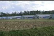 As the Southern Table Plateau (68d) decreases in elevation to the southwest, agricultural land cover increases, and includes pasture, corn, soybeans, potatoes, hay, and poultry. As the Southern Table Plateau (68d) decreases in elevation to the southwest, agricultural land cover increases, and includes pasture, corn, soybeans, potatoes, hay, and poultry. |
|
71 . Interior Plateau | |
|
71f. The Western Highland Rim is characterized by weakly to moderately dissected rolling terrain of irregular plains and open hills. In Alabama, the ecoregion tends to have less relief and dissection than in Tennessee. The limestone, chert, siltstone, and shale is covered by soils that are cherty, acidic, and low to moderate in fertility. Streams are characterized by coarse chert gravel and sand substrates with areas of bedrock, low to moderate gradients, and relatively clear water. Although the steeper, more dissected side slopes tend to be forested, most of the natural vegetation has been removed from the broad, level uplands for pasture and cropland. Cattle production is locally significant, and hay, cotton, and soybeans, with some wheat and corn, comprise much of the cropland. |
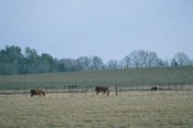 Pasture and cattle, with some scattered cropland, are typical on the rolling Alabama portion of 71f. To the north in Tennessee the Western Highland Rim becomes more hilly and forested. Pasture and cattle, with some scattered cropland, are typical on the rolling Alabama portion of 71f. To the north in Tennessee the Western Highland Rim becomes more hilly and forested. 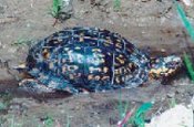 In Alabama, the terrestrial eastern box turtle is found mostly in the northern third of the state in moist forest habitats. In Alabama, the terrestrial eastern box turtle is found mostly in the northern third of the state in moist forest habitats. 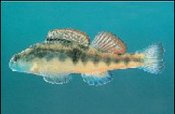 The black darter is restricted to small and medium streams with gravelly or slabrock bottoms of the Tennessee River drainage. The black darter is restricted to small and medium streams with gravelly or slabrock bottoms of the Tennessee River drainage. |
|
75 . Southern Coastal Plain | |
|
75a. In Alabama, the Gulf Coast Flatwoods is a narrow region of nearly level terraces and delta deposits composed of Quaternary sands and clays. Wet, sandy flats and broad depressions that are locally swampy are usually forested, while some of the better-drained land has been cleared for pasture or crops. Most of the Mobile urban area is also contained in this region. |
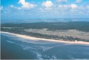 The web of interrelated coastal environments, including beaches, barrier islands, maritime forests, marshes, and estuaries, is continually changed by wave, tide, wind, and river energy, and has a long history of human alterations. Sapelo Island, GA, has seen Native American cultivation of corn, melons, squash, and beans; a Spanish mission period during the 1500-1600's with crops including citrus, figs, peaches, olives, artichokes, and onions; and a plantation agriculture economy in the late 1700's through the 1800's that produced indigo, rice, sugar cane, and sea island cotton. (Photo: Sapelo Island National Estuarine Research Reserve) The web of interrelated coastal environments, including beaches, barrier islands, maritime forests, marshes, and estuaries, is continually changed by wave, tide, wind, and river energy, and has a long history of human alterations. Sapelo Island, GA, has seen Native American cultivation of corn, melons, squash, and beans; a Spanish mission period during the 1500-1600's with crops including citrus, figs, peaches, olives, artichokes, and onions; and a plantation agriculture economy in the late 1700's through the 1800's that produced indigo, rice, sugar cane, and sea island cotton. (Photo: Sapelo Island National Estuarine Research Reserve) 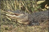 Alligators, removed from the endangered species list in 1987, are an integral component of many wetland ecosystems in the Southern Coastal Plain (75). (Photo: Tom Atwood) Alligators, removed from the endangered species list in 1987, are an integral component of many wetland ecosystems in the Southern Coastal Plain (75). (Photo: Tom Atwood) 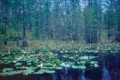 Standing water is common in many parts of ecoregion 75 for all or parts of the year. The Okefenokee Swamp is a rainfall-dependent system, and cycles of drought and fire affect both its vegetation and wildlife distributions. (Photo: USGS Florida Caribbean Science Center) Standing water is common in many parts of ecoregion 75 for all or parts of the year. The Okefenokee Swamp is a rainfall-dependent system, and cycles of drought and fire affect both its vegetation and wildlife distributions. (Photo: USGS Florida Caribbean Science Center) |
Notes
- The full, original version of this entry is located here: http://www.epa.gov/wed/pages/ecoregions/alga_eco.htm. That description contains additional maps, as well as information on the physiography, geology, soil, potential natural vegetation, and the land use and land cover of the ecoregion.
- PRINCIPAL AUTHORS: Glenn E. Griffith (NRCS), James M. Omernik (USEPA), Jeffrey A. Comstock (OAO Corporation), Steve Lawrence (NRCS), George Martin (NRCS), Art Goddard (USFS), Vickie J. Hulcher (ADEM), and Trish Foster (GA DNR).
- COLLABORATORS AND CONTRIBUTORS: Hoke Howard (USEPA), Jim Harrison (USEPA), Greg Lein (Alabama Department of Conservation and Natural Resources DCNR), Bruce Pruitt (USEPA), Patti Lanford (GA DNR), Bob Cooner (ADEM), Jon Hornsby ([DCNR]), Dave Melgaard (USEPA), Tom Loveland (USGS), Lawrence McGee (NRCS), Shannon Winsness (GA DNR), Bill Kennedy (GA DNR), Becky Blasius (GA DNR), Kristen Sanford (GA DNR), Dick Rightmyer (USFS), and Ron Stephens (USFS).
- REVIEWERS: Burchard Carter (Georgia Southwestern State Univ.), Pat O'Neil (Geological Survey of AL), Cliff Webber (Auburn Univ.), and Larry West (Univ. of GA).
- CITING THIS POSTER: Griffith, G.E., Omernik, J.M., Comstock, J.A., Lawrence, S., Martin, G., Goddard, A., Hulcher, V.J., and Foster, T., 2001, Ecoregions of Alabama and Georgia, (color poster with map, descriptive text, summary tables, and photographs): Reston, Virginia, U.S. Geological Survey (map scale 1:1,700,000).
- This project was partially supported by funds from the Alabama Department of Environmental Management and the Georgia Department of Natural Resources through grants provided by the U.S. Environmental Protection Agency Region IV under the provisions of Section 319(h) of the Federal Water Pollution Control Act .
Literature Cited
- Bailey, R.G., Avers, P.E., King, T., and McNab, W.H., eds., 1994, Ecoregions and subregions of the United States (map) (supplementary table of map unit descriptions compiled and edited by McNab, W.H. and Bailey, R.G.): Washington, D.C., U.S. Department of Agriculture-Forest Service, scale 1:7,500,000.
- Commission for Environmental Cooperation Working Group, 1997, Ecological regions of North America - toward a common perspective: Montreal, Quebec, Commission for Environmental Cooperation, 71 p.
- Gallant, A.L., Whittier, T.R., Larsen, D.P., Omernik, J.M., and Hughes, R.M., 1989, Regionalization as a tool for managing environmental resources: Corvallis, Oregon, U.S. Environmental Protection Agency, EPA/600/3-89/060, 152 p.
- Griffith, G.E., Omernik, J.M., Wilton, T.F., and Pierson, S.M., 1994, Ecoregions and subregions of Iowa - a framework for water quality assessment and management: The Journal of the Iowa Academy of Science, v. 101, no. 1, p. 5-13.
- Omernik, J.M., 1987, Ecoregions of the conterminous United States (map supplement): Annals of the Association of American Geographers, v. 77, no. 1, p. 118-125, scale 1:7,500,000.
- Omernik, J.M., 1995, Ecoregions - a framework for environmental management, in Davis, W.S. and Simon, T.P., eds., Biological assessment and criteria-tools for water resource planning and decision making: Boca Raton, Florida, Lewis Publishers, p. 49-62.
- Omernik, J.M., Chapman, S.S., Lillie, R.A., and Dumke, R.T., 2000, Ecoregions of Wisconsin: Transactions of the Wisconsin Academy of Sciences, Arts and Letters, v. 88, no. 2000, p. 77-103.
- U.S. Department of Agriculture-Soil Conservation Service, 1981, Land resource regions and major land resource areas of the United States: Agriculture Handbook 296, 156 p.
- U.S. Environmental Protection Agency, 2000, Level III ecoregions of the continental United States (revision of Omernik, 1987): Corvallis, Oregon, U.S. Environmental Protection Agency-National Health and Environmental Effects Research Laboratory, Map M-1, various scales.
- Wiken, E., 1986, Terrestrial ecozones of Canada: Ottawa, Environment Canada, Ecological Land Classification Series no. 19, 26 p.
| Disclaimer: This article is taken wholly from, or contains information that was originally published by, the Environmental Protection Agency. Topic editors and authors for the Encyclopedia of Earth may have edited its content or added new information. The use of information from the Environmental Protection Agency should not be construed as support for or endorsement by that organization for any new information added by EoE personnel, or for any editing of the original content. |