This level III and IV ecoregion map was compiled at a scale of 1:250,000; it depicts revisions and subdivisions of earlier level III ecoregions that were originally compiled at a smaller scale (USEPA 1997; Omernik 1987). The poster is part of a collaborative project primarily between the USEPA Region V, the USEPA National Health and Environmental Effects Research Laboratory, Corvallis, Oregon, the Indiana Department of Environmental Management (IDEM), the Ohio Department of Natural Resources (ODNR), the Ohio Environmental Protection Agency (Ohio EPA), the United States Department of Agriculture - Forest Service (USFS), the United States Department of Agriculture - Natural Resources Conservation Service (NRCS) (formerly the Soil Conservation Service), and the United States Department of the Interior - U.S. Geological Survey (USGS) - Earth Resources Observation Systems (EROS) Data Center.
This project is associated with an interagency effort to develop a common framework of ecological regions. Reaching that objective requires recognition of the differences in the conceptual approaches and mapping methodologies that have been used to develop the most commonly used existing ecoregion-type frameworks, including those developed by the USFS (Bailey and others, 1994), the USEPA (Omernik 1987, 1995), and the NRCS (U.S. Department of Agriculture - Soil Conservation Service, 1981). As each of these frameworks is further developed, the differences between them lessen. Regional collaborative projects such as this one in Indiana and Ohio, where agreement can be reached among multiple resource management agencies, is a step in the direction of attaining commonality and consistency in ecoregion frameworks for the entire nation.
|
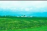
54. Central Corn Belt Plains
Extensive prairie communities were native to the glaciated plains of Ecoregion 54; they were a stark contrast to the hardwood forests that grew farther east on the drift plains of Ecoregions 55 and 56. Beginning in the nineteenth century, the natural vegetation was gradually replaced by agriculture. Farms are now extensive on the dark, fertile soils of Ecoregion 54 and grow, primarily, corn and soybeans; cattle, sheep, poultry, and, especially, hogs are also raised, but they are not as dominant as farther west in the drier Western Corn Belt Plains (47). Agriculture has affected stream chemistry, turbidity, and habitat.
|
|
54a. The Illinois/Indiana Prairies ecoregion is undulating and characterized by dark, very fertile soils. Today, corn, soybean, and livestock farming has replaced the original prairie and oak-hickory forest; woodland is largely confined to riparian areas. Low gradient, silt-bottomed streams have cut into the limy glacial and lacustrine deposits of Ecoregion 54a; they are warm in the summer, impacted by field runoff and channelization, and often carry a large amount of suspended sediment.
54b. The Chicago Lake Plain ecoregion is a nearly level coastal strip with beach ridges, marshy swales, and sand dunes. It is differentiated from inland ecoregions by its lake-moderated climate and native beach-dune plant communities. Ecoregion 54b has lower dunes, fewer woodlands, and more urban-industrial activity than Ecoregion 56d.
54c. The Kankakee Marsh ecoregion was once covered by extensive northern swamp forests, wet prairies, and bulrush-cattail marshes. Today, most of these distinctive communities are gone and only a narrow wooded corridor remains along the Kankakee River. Elsewhere, corn, soybean, and livestock farming is dominant on artificially drained soils that were derived from outwash deposits.
54d. The Kankakee Sand Area ecoregion is distinguished from adjacent ecoregions by its extensive sand plains and relict dunes. Natural soil drainage properties and vegetation were distinctive; dry prairies and mixed oak savannas occurred on well-drained sites while northern swamp forests, marshes, or wet prairies grew on moister soils. Today, the dunes remain wooded. Crop productivity is lower than in Ecoregion 54b.
|
 Ecoregion 54a was once prairie. The natural vegetation has been replaced by corn, soybean, and livestock farming. Ecoregion 54a was once prairie. The natural vegetation has been replaced by corn, soybean, and livestock farming.
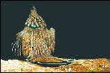
 The banded darter is a representative species of Ecoregion 54a. (Photo: Mac Albin, Columbus Metro-Parks) The banded darter is a representative species of Ecoregion 54a. (Photo: Mac Albin, Columbus Metro-Parks) |
|
|
|
55. Eastern Corn Belt Plains
Ecoregion 55 is primarily a rolling till plain with local end moraines. It has lighter colored soils than Ecoregion 54, loamier and better drained soils than Ecoregion 57, and richer soils than Ecoregion 61. Glacial deposits of Wisconsinan age are extensive; they are not as dissected nor as leached as the pre-Wisconsinan till which is restricted to the southern part of Ecoregion 55. Originally, natural tree cover was greater than Ecoregion 54; beech forests were common on Wisconsinan soils while beech forests and elm-ash swamp forests dominated the wetter pre- Wisconsinan soils. Today, extensive corn, soybean, and livestock production occurs and has affected stream chemistry and turbidity.
|
|
55a. The Clayey, High Lime Till Plains ecoregion is transitional between the Loamy, High Lime Till Plains (55b) and the Maumee Lake Plains (57a); soils are less productive and more artificially drained than Ecoregion 55b and supported fewer swampy areas than Ecoregion 57a. Corn, soybean, wheat, and livestock farming is dominant and has replaced the original beech forests and scattered elm-ash swamp forests. No exceptional fish communities exist in the turbid, low gradient streams of Ecoregion 55a.
55b. The Loamy, High Lime Till Plains ecoregion contains soils that developed from loamy, limy, glacial deposits of Wisconsinan age; these soils typically have better natural drainage than those of Ecoregion 55a and have more natural fertility than those of Ecoregion 55d. Beech forests, oak-sugar maple forests, and elm-ash swamp forests grew on the nearly level terrain; today, corn, soybean, and livestock production is widespread.
55c. The Mad River Interlobate Area ecoregion is flanked by end moraines and received concentrated outwash deposits that filled preglacial valleys. Abundant groundwater feeds its distinctive cold water streams that contain an abundance of riffle-inhabiting fish species. Originally, beech forest, mixed oak forest, and extensive freshwater fens/wet prairies were common in Ecoregion 55c. Today, extensive corn, soybean, dairy, and livestock farms as well as urban activity occur. Woodland still grows on steep sites and along riparian corridors; fresh water fens/wet prairies can also be found locally.
55d. The Pre-Wisconsinan Drift Plains ecoregion is differentiated from the surrounding ecoregions by its deeply-leached, acidic, pre-Wisconsinan till and thin loess; widespread areas of nearly flat, very poorly-drained soils with fragipans are also distinctive. In addition, some dissected areas occur. Streams often have more sustained runoff and biotic diversity than those of Ecoregion 55b. Originally, beech forests and elm-ash swamp forests were dominant. Today, soybeans are common and are well adapted to spring soil wetness; corn, tobacco, and livestock farming also occurs.
55e. The Darby Plains ecoregion once had a distinct assemblage of mixed oak forest; many prairies occurred on its end moraines, gravel-filled preglacial valleys, and seasonally wet areas. Today, tree density is less than in Ecoregion 55b and very large, productive crop and livestock farms occur on its level to undulating terrain. Big Darby Creek, a State and National Scenic River, has high fish diversity (Species diversity).
55f. The Whitewater Interlobate Area ecoregion has distinctive cool water, coarsebottomed streams that are perennial and fed by abundant groundwater. The redside dace, northern stud fish, and banded sculpin occur; they are absent or uncommon in Ecoregion 55b. Unique Ozarkian invertebrates also occur in Ecoregion 55f. Dolomitic drift and meltwater deposits are characteristic and overlie limestone, calcareous shale, and dolomitic mudstone.
|
 Ecoregion 55a is a level, clayey, limy till plain. Its agricultural soils need artificial drainage. Ecoregion 55a is a level, clayey, limy till plain. Its agricultural soils need artificial drainage.
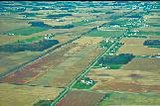
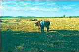
 Large agricultural fields and very limited woodland are typical of Ecoregion 55e. Large agricultural fields and very limited woodland are typical of Ecoregion 55e.
 The bluebreast darter is threatened in Ohio; it occurs in the swift, rocky riffles of Big Darby Creek, a State and National Scenic River in Ecoregion 55e. (Photo: Roger F. Thoma, Ohio EPA) The bluebreast darter is threatened in Ohio; it occurs in the swift, rocky riffles of Big Darby Creek, a State and National Scenic River in Ecoregion 55e. (Photo: Roger F. Thoma, Ohio EPA)
|
|
|
|
56. Southern Michigan/Northern Indiana Drift Plains
Ecoregion 56 is distinguished from adjacent ecoregions by its many lakes and marshes as well as its wider assortment of landforms, soil types, soil textures, and land uses. Broad till plains with thick and complex deposits of drift, paleobeach ridges, relict dunes, morainal hills, kames, drumlins, meltwater channels, and kettles occur. Feed grain, soybean, and livestock farming as well as woodlots, quarries, recreational development, and urban-industrial areas are common. An assortment of soils developed under oak-hickory forests, northern swamp forests, or beech forests. Bogs and bog soils are also locally common. Low to medium gradient streams occur and often have rocky bottoms and low amounts of suspended sediment.
|
|
56a. The Lake Country ecoregion is a hummocky and pitted morainal area characterized by many pothole lakes, ponds, marshes, bogs, and clear streams. The well-drained end moraines and kames once supported oak-hickory forests whereas wetter areas had beech forests or northern swamp forests; the very poorly-drained kettles had tamarack swamp, cattail-bulrush marshes, or sphagnum bogs. Today, marshes and woodland remain but corn, soybean, and livestock farming is dominant; recreational and residential developments commonly surround the lakes of Ecoregion 56a.
56b. The Elkhart Till Plains ecoregion is punctuated by end moraines, kames, and lacustrine flats; kettlehole lakes occur but are much rarer than in Ecoregion 56a while sand dunes are less common than in Ecoregions 54d or 56d. Oak-hickory forests and beech maple forests once dominated Ecoregion 56b but, today, corn, soybean, and wheat farming is more extensive than woodland. Land use is more diversified than in the Eastern Corn Belt Plains (55).
56c. The Middle Tippecanoe Plains ecoregion is level to rolling and covered by ground moraine, dunes, end moraines, and lacustrine deposits. The Tippecanoe River drains this area and has cooler water and greater species diversity than found in adjacent areas of Ecoregions 54 and 55. Its cold water tributaries are fed by abundant groundwater; their temperature and fish fauna are distinct from those of Ecoregion 56b.
56d. The Michigan Lake Plain ecoregion is a sandy coastal strip with beaches, high dunes, beach ridges, mucky interdunal depressions, and swales. Its lake-moderated climate as well as its beach and dune plant communities differentiate it from inland ecoregions. Ecoregion 56d has greater relief, higher woodland density, more conifers in its savanna community, and less made-land than the Chicago Lake Plain (54b). Urban and industrial activity as well as fruit and vegetable farming occurs; scattered woodland grows on the lee side of dunes and in some poorly-drained areas.
|
 Ecoregion 56a is a hummocky morainal area with cropland, woodlots, and many lakes. Ecoregion 56a is a hummocky morainal area with cropland, woodlots, and many lakes.
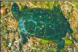 The spotted turtle lives in still, clear, shallow and vegetated water; it is threatened in Indiana but occurs in Ecoregions 56a and 56d.(Photo: Indiana Dunes National Lakeshore) The spotted turtle lives in still, clear, shallow and vegetated water; it is threatened in Indiana but occurs in Ecoregions 56a and 56d.(Photo: Indiana Dunes National Lakeshore)
|
|
|
|
57. Huron/Erie Lake Plains
Ecoregion 57 is a broad, fertile, nearly flat plain punctuated by relict sand dunes, beach ridges, and end moraines. Originally, soil drainage was typically poorer than in Ecoregion 55 and elmash swamp and beech forests were dominant. Oak savanna was typically restricted to sandy, well-drained dunes and beach ridges. Today, most of the area has been cleared and artificially drained and contains highly productive farms producing corn, soybeans, livestock, and vegetables; urban and industrial areas are also extensive. Stream habitat and quality have been degraded by channelization, ditching, and agricultural activities.
|
|
57a. The Maumee Lake Plains ecoregion is poorly-drained and contains clayey lake deposits, water-worked glacial till, and fertile soils. Elm-ash swamp forests and beech forests once were extensive; marshes and bogs occurred along the coast. They have been replaced by productive, drained farmland. Sluggish, low gradient rivers wind through Ecoregion 57a and have high suspended sediment loads of clayey silts that endanger biota.
57b. The Oak Openings ecoregion is a belt of low, often wooded, sand dunes and paleobeach ridges that are situated among the broad, nearly flat, agricultural plains of Ecoregion 57a. Well-drained, sandy soils are common and originally supported mixed oak forests and oak savanna; poorly-drained depressions with wet prairies were also found. Today, general farms, residential development, oak woodland, and sand quarries occur.
57c. The Paulding Plains ecoregion is a part of the lake plain and is characterized by clayey lacustrine sediment and extensive, very poorly-drained, illitic soils such as the Paulding and Roselms. The nearly level, level, and depressional topography supported mostly elm-ash swamp forest but now has been cleared and drained for soybean, small grain, corn, and hay farming. Its very sluggish, low-gradient streams and many ditches are typically turbid and have very high loads of suspended clay that endanger biota.
57d. The Marblehead Drift/Limestone Plain ecoregion has areas of thin glacial drift and limestone-dolomite ridges and islands. Streams often flow on carbonate bedrock; their character is different from the clayey channels of Ecoregions 57a and 57c. Originally, beech forests and, especially, elm-ash swamp forests were common. Scattered carbonate ridges supported distinctive mixed oak forests and prairies, marl plains had prairies, and the Lake Erie and Sandusky Bay shoreline often supported fens. Many geographically isolated plant species occurred in Ecoregion 57d. Today, corn, small grains, soybeans, and hay are grown on artificially drained land. Vegetable and fruit farming is well adapted to the relatively mild climate near the shoreline.
|
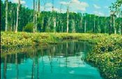
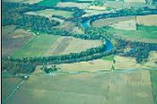 The low gradient, turbid Maumee River winds through the clayey lake plain of Ecoregion 57a. The low gradient, turbid Maumee River winds through the clayey lake plain of Ecoregion 57a.
 Ecoregion 57b has poorly drained areas. (Photo: Brian Alsdorf, Ohio EPA) Ecoregion 57b has poorly drained areas. (Photo: Brian Alsdorf, Ohio EPA)
|
|
|
|
61. Erie/Ontario Drift and Lake Plain
Low lime drift and lacustrine deposits blanket the rolling to level terrain of Ecoregion 61. Lakes, wetlands, and [[swamp]y] streams occur where stream networks are deranged or where the land is flat and clayey. Soils are often lower in carbonate and naturally less fertile than those of other glaciated ecoregions. Urban development, industrial activity, and agriculture are widespread and scattered woodland also occurs. [[Lake Erie]’s] influence substantially increases the growing season, winter cloudiness, and snowfall of the northernmost areas.
|
|
61a. The Erie Lake Plain ecoregion is a nearly level coastal strip of lacustrine deposits punctuated by beach ridges and swales. Its lake-modified climate sets it apart from other nearby ecoregions and its annual growing season is often several weeks longer than inland areas. Urban-industrial sites, ports, fruit-vegetable farms, and nurseries have developed on the plain.
61b. The Mosquito Creek/Pymatuning Lowlands ecoregion is characterized by poor drainage, wetlands, low-gradient streams, and moisture tolerant woodlands. It is nearly flat and is underlain by clayey till and fine lacustrine deposits. Originally, beech forests were common; today dairy farms and woodlots occur.
61c. The Low Lime Drift Plain ecoregion has a rolling landscape composed of low rounded hills with scattered end moraines and kettles; its terrain is distinct from the unglaciated, wooded, hilly country of Ecoregion 70 and its soils are usually less naturally fertile than the high lime till plains of Ecoregion 55. Urban-industrial activity as well as dairy, livestock, corn, and soybean farming are common; many ridges and lowlands are wooded. The growing season is shorter than that of Ecoregion 61a, and progressively decreases away from Lake Erie.
61d. The Erie Gorges ecoregion is a uniquely steep, dissected area along the Chagrin, Cuyahoga, and Grand rivers. Local relief can exceed 500 feet, rock exposures occur, and fluvial erosion rates are high. Originally, mixed mesophytic forests were common on well-drained sites; today, woodland, recreational areas, scattered farms, and housing are dominant.
61e. The Summit Interlobate Area is set apart from adjacent ecoregions by its numerous lakes, wetlands, sphagnum bogs, sluggish streams, kames, and kettles. The substrate is often sandy outwash and till. Mixed oak forests originally dominated well-drained areas; today, woodland, peatland, agriculture, gravel quarries, and urban-suburban development occurs.
|
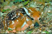 Whitetail deer were once common in Ohio but were hunted-out by 1904. Now reestablished and managed, they occur in many ecoregions. Whitetail deer were once common in Ohio but were hunted-out by 1904. Now reestablished and managed, they occur in many ecoregions.
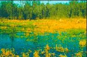
 Poorly drained, nearly level lowlands along swampy Pymatuning Creek in Ecoregion 61b. (Photo: Brian Alsdorf, Ohio EPA) Poorly drained, nearly level lowlands along swampy Pymatuning Creek in Ecoregion 61b. (Photo: Brian Alsdorf, Ohio EPA) |
|
|
|
70. Western Allegheny Plateau
The hilly and wooded terrain of Ecoregion 70 was not muted by glaciation and is more rugged than the agricultural till plains of Ecoregions 55 and 61. Extensive mixed mesophytic forests and mixed oak forests originally grew in Ecoregion 70. Today, most of its rounded hills remain in forest; dairy, livestock, and general farms as well as residential developments are concentrated in the valleys. Horizontally-bedded, sedimentary rock underlies the region and has been mined for bituminous coal.
|
|
70a. The Permian Hills ecoregion is rugged, wooded, and, commonly, too steep to be farmed. High gradient streams without acidity problems are characteristic and have developed on the underlying Permian shale, sandstone, and coal; on shale, the streams are often ephemeral and without large riffle-inhabiting fish populations.
70b. The Monongahela Transition Zone has rounded hills and ridges that are generally less rugged than Ecoregion 70a but are still steep. Unstable, clayey regolith has developed on the underlying coal bearing strata but is largely absent from Ecoregions 70c, 70d, and 70f. Gas wells, coal mining, and reclaimed land are locally extensive and associated stream degradation is common. Forests occupy steeper areas; dairy, livestock, and general farms also occur.
70c. The Pittsburgh Low Plateau ecoregion has rounded, forested hills and narrow, agricultural valleys; it is largely unglaciated in contrast to neighboring Ecoregion 61c. Medium textured soils are common and are markedly different from the clayey soils of Ecoregion 70b. High gradient streams with rocky bottoms and associated fauna contrast with the lower gradient, silty or sandy channels of Ecoregion 70e. Coal mining and associated stream acidity problems are present but less common than in Ecoregions 70b and 70e.
70d. The Lower Scioto Dissected Plateau ecoregion is rugged, dissected, and underlain by Mississippian-age shale and sandstone. It is characterized by steep ridges, high relief, and streams without acidity problems. Low gradient, broad valleys also occur. Originally, mixed oak forests and mixed mesophytic forests were widespread and bottomland hardwood forests were restricted to broad, flat-bottomed valleys. Today, the steep areas are still wooded; livestock, general, and tobacco farming occurs in less rugged areas.
70e. The Unglaciated Upper Muskingum Basin ecoregion is a dissected plateau with streams that are less degraded by coal mine effluent than those of Ecoregions 70b or 70f. Originally, mixed oak forests and mixed mesophytic forests were widespread. Underfit, low gradient rivers occur in broad, silt-filled, Wisconsinan-age valleys.
70f. The Ohio/Kentucky Carboniferous Plateau ecoregion is characterized by extensive bituminous coal mining and associated stream degradation; mining and its effects are less prominent in Ecoregion 70e and absent from Ecoregion 70d. The ridges of Ecoregion 70f are forested while its floodplains and broad, clay-filled, flat-bottomed, preglacial valleys are used for general farms. Originally, the hill slopes had mixed oak forests, while the broad, Teays-age valleys supported mixed mesophytic forests.
|
 Ecoregion 70b has surface bituminous coal mines, reclaimed land, and disturbed drainage. Ecoregion 70b has surface bituminous coal mines, reclaimed land, and disturbed drainage.
 The ruffed grouse initially benefited from forest segmentation but habitat reduction and hunting later reduced its population. After 1930, its numbers again increased when hill farms were abandoned and hunting regulated. (Photo: Mac Albin, Columbus Metro-Parks) The ruffed grouse initially benefited from forest segmentation but habitat reduction and hunting later reduced its population. After 1930, its numbers again increased when hill farms were abandoned and hunting regulated. (Photo: Mac Albin, Columbus Metro-Parks)
 Low-gradient streams in over-fit valleys are locally common in Ecoregion 70e. Low-gradient streams in over-fit valleys are locally common in Ecoregion 70e. |
|
|
|
71. Interior Plateau
Ecoregion 71 has rolling to deeply dissected, rugged terrain with areas of karst topography common on the Mitchell Plain (71b). Maximum elevations and local relief are greater than in Ecoregion 72. The original forest vegetation shared its beech component with Ecoregion 55 and oak-hickory forests occurred on the well-drained, upper slopes. The soils of Ecoregion 71 developed from the underlying sandstone, siltstone, shale, and limestone and are not from till like those of Ecoregion 55. Land use/land cover is a transition between the crop and livestock farms of Ecoregion 55 and the forests of Ecoregion 70; hay, grain, cattle, hog, and poultry farming occurs and woodland is common.
|
|
71a. The Crawford Uplands ecoregion is heavily dissected by medium to high gradient streams and is more rugged and wooded than Ecoregion 71b. Oaks are found on well-drained upper slopes, mixed mesophytic forest occurs in coves as well as on north facing slopes, and specialized plant communities dominate the eastern sandstone-limestone cliffs. General farms occur especially in the west and in the wider valleys.
71b. The Mitchell Plain is differentiated from adjacent ecoregions by its karst topography, low relief, residential-urban areas, and limestone quarries; its peripheral hills are wooded. The north experienced pre-Wisconsinan glaciation and is flatter and more poorly-drained than the unglaciated part which is dominated by sink holes, underground drainage, and terra rossa soils. Soils are leached and largely developed from loess and limestone. Western mesophytic forests were once dominant; karst wetland communities and limestone glades also occurred and were the major examples of these communities in Indiana.
71c. The Norman Upland ecoregion is mostly forested in contrast to Ecoregions 55b, 55d, and 71b which are adjacent and less rugged. It is characterized by dissected high hills and knobs, narrow valleys, and medium to high gradient streams. The silt loam soils were derived from loess, siltstone, shale, or sandstone. Originally, oak-hickory forests grew on the uplands and beech forests were found in the valleys. Today, chestnut oak has replaced American chestnut on the well-drained upper slopes; Virginia pine grows on the southern uplands.
71d. The Northern Bluegrass ecoregion is deeply dissected and has some ephemeral streams in the east. The east is unglaciated whereas the plains and hills of the west are mantled by leached pre-Wisconsinan till and discontinuous loess. Ecoregion 71d is underlain by Ordovician limestone and shale which distinguishes it from other nearby ecoregions. Its lower crestal elevations, Alfisol soils, limestone bedrock, and sinkholes distinguish it from Ecoregion 70d; its ruggedness, lack of fragipans, and, often, natural vegetation differentiate it from the glaciated plains of Ecoregion 55d. In addition, Ecoregion 71d lacks the high lime, Wisconsinan till of Ecoregion 55b. Originally, in Ohio, mixed mesophytic forests, mixed oak forests, and bottomland hardwood forests grew; in Indiana, western mixed mesophytic forests and oak-hickory forests grew and they lacked many northern species. Today, the ecoregion is a mosaic of forest and agriculture with urban-industrial activity occurring near Cincinnati and along the Ohio River. It is wooded where steep; general, dairy, and tobacco farming occurs on less rugged sites.
|
 General farming occurs in the wider valleys of Ecoregion 71a. General farming occurs in the wider valleys of Ecoregion 71a.
 Mississippian limestone underlies Ecoregion 71b. It is extensively quarried. Mississippian limestone underlies Ecoregion 71b. It is extensively quarried.
 Extensive woodland typifies Ecoregion 71c. Extensive woodland typifies Ecoregion 71c.
|
|
|
|
72. Interior River Lowland
This broad, undulating lowland was formed in non-resistant, non-calcareous sedimentary rock. Large upland areas along the Wabash River are veneered by windblown material which thins eastward. Pre-Wisconsinan ice once covered much of the ecoregion and till deposits can be found locally north of the White River. Many wide, flat-bottomed, terraced valleys occur and are filled with alluvium as well as outwash, aeolian, and lacustrine deposits. Bottomland hardwood forests, [[swamp]s], and beech forests once grew on poorly-drained, nearly level sites along the Wabash and Ohio rivers whereas the upland areas had beech forests and oak-hickory forests. Patterns of land use (Land-use and land-cover change) are more varied than in the neighboring ecoregions. Drained alluvial soils are farmed for feed grains and soybeans. Undrained valley sites are used for forage crops, pasture, or woodlots; upland soils are used for mixed farming and livestock. Extensive strip mining as well as crop and livestock production have impacted stream water quality and stream habitat; sheet erosion can be severe on cultivated slopes.
|
|
72a. The Wabash Bottomlands ecoregion is found along the lower Wabash and Ohio rivers. Ecoregion 72a contains the most pronounced Mississippian-type biotic assemblage in Indiana and, historically, significant numbers of waterfowl have wintered here. The low, nearly level floodplains, terraces, and bayous are composed of alluvial and outwash deposits; they were seasonally inundated before flood control and were once covered by bottomland hardwood forests. Today, some woodland remains but, mostly, the land is used for corn, soybean, wheat, alfalfa, or livestock farming; poor drainage and droughtiness are critical factors controlling land use.
72b. The Glaciated Wabash Lowlands ecoregion is often mantled by till or windblown silt and sand. The loamy to sandy till deposits are pre-Wisconsinan in age and are older and more leached than the glacial drift of Ecoregions 54a and 55b. The original vegetation included beech forest and oak-hickory forest; relict sand dunes sometimes supported prairies. Today, the productive soils support corn, soybean, wheat, and vegetable farming; scattered woodlands and surface coal mines also occur. Many streams have gravel bottoms, riffles, and associated fauna; they are less sluggish than the streams of Ecoregion 72c.
72c. The Southern Wabash Lowlands ecoregion is undulating to rolling and has many wide, shallow valleys. It lies to the south of Ecoregion 72b and its pre-Wisconsinan till plain; relict dunes and wind-blown silt deposits occur in the west, and shale and sandstone bedrock is exposed in the east. Ecoregion 72c is further characterized by its long growing season and neutral to acid soils. Originally, oak-hickory forests grew on the well-drained upland soils while western mesophytic forests occurred on more poorly-drained soils; some southern plants reached their northern distributional limit in Ecoregion 72c. Today, the woodland has been mostly cleared for corn, soybean, wheat, livestock, and vegetable farming as well as extensive surface coal mines.
|
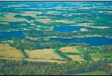
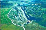
 The undulating Interior River Lowland (72) and its cropland and scattered woodland. The undulating Interior River Lowland (72) and its cropland and scattered woodland.
|
 Ecoregions of Indiana and Ohio.
  Level III Ecoregions of the Conterminous United States. (Map source: USEPA, 2000)