Ecoregions of Minnesota (EPA)
| Topics: |
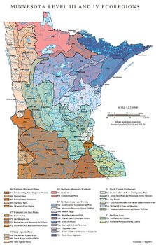 Ecoregions of Minnesota.
 Ecoregions denote areas of general similarity in ecosystems and in the type, quality, and quantity of environmental resources; they are designed to serve as a spatial framework for the research, assessment, management, and monitoring of ecosystems and ecosystem components. By recognizing the spatial differences in the capacities and potentials of ecosystems, ecoregions stratify the environment by its probable response to disturbance (Bryce and others, 1999). These general purpose regions are critical for structuring and implementing ecosystem management strategies across federal agencies, state agencies, and nongovernment organizations that are responsible for different types of resources within the same geographical areas (Omernik and others, 2000).
The approach used to compile this map is based on the premise that ecological regions can be identified through the analysis of the spatial patterns and the composition of biotic and abiotic phenomena that affect or reflect differences in ecosystem quality and integrity (Wiken, 1986; Omernik, 1987, 1995). These phenomena include geology, physiography, vegetation, climate, soils, land use, wildlife, and hydrology.
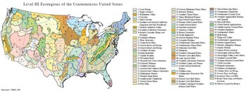 Level III Ecoregions of the Conterminous United States. (Map source: USEPA, 2000)
 The relative importance of each characteristic varies from one ecological region to another regardless of the hierarchical level. A Roman numeral hierarchical scheme has been adopted for different levels of ecological regions. Level I is the coarsest level, dividing North America into 15 ecological regions. Level II divides the continent into 52 regions (Commission for Environmental Cooperation Working Group, 1997). At level III, the continental United States contains 104 ecoregions and the conterminous United States has 84 ecoregions (United States Environmental Protection Agency [USEPA], 2003). Level IV is a further subdivision of level III ecoregions. Explanations of the methods used to define the USEPA’s ecoregions are given in Omernik (1995), Omernik and others (2000), Griffith and others (1994), and Gallant and others (1989).
| Ecoregion | Description |
| 46. Northern Glaciated Plains | |
| 46e. Tewaukon/Big Stone Stagnation Morraine |
Gently undulating moraine field with mix of row crops, many small lakes, marshes (Non-tidal marsh), and potholes. |
| 46k. Prarie Coteau |
Higher elevation plateau with poorly defined drainage, many lakes, and mix of row crops and some pasture. |
| 46l. Prarie Coteau Escarpment |
Slopes from plateau to river basin with perennial streams and riparian vegatation, and row crops on interfluves. |
| 46m. Big Sioux Basin | Plateau of older loess covered till with row crops, pasture and no lakes. |
| 46o. Minnesota River Prarie |
Generally level plain with mostly row crops on deep soils and with some lakes and wetlands. |
| 47 Western Corn Belt Plains | |
| 47a. Loess Praries |
Loess covered undulating plain with dissecting rivers and predominantly row crops. |
| 47b. Des Moines Lobe | Vast fertile plain of deep soils dominated by row crops. |
| 47c. Eastern Iowa and Minnesota Drift Plains | Older till plain with mostly row crops and some pasture. |
| 47g. Lower St Croix and Vermillon Valleys | Dissected till plain and outwash valleys with mix of row crops and pasture. |
| 48. Lake Agassiz Plain | |
| 48a. Glacial Lake Agassiz Basin | Flat former lake bed dominated by row crops and grains. |
| 48b. Beach Ridges and Sand Deltas |
Low ridges of gravel and sand with mix of row crops, small grains, woodland, and wetlands. |
| 48d. Lake Agassiz Plains | Flat land higher than 48a with row crops, small grains, and pasture. |
| 49. Northern Minnesota Wetlands | |
| 49a. Peatlands | |
| 49b. Forested Lake Plains |
Flat to gently sloping plain with extensive wetlands, some forest and several eroded river channels. |
| 50. Northern Lakes and Forests | |
| 50a. Lake Superior Lacustrine Clay Plain |
Clay-covered former lake bed strongly dissected having mixed land use. |
| 50b. Minnesota/Wisconsin Upland Till Plain | Rolling landscape of woods, wetlands, pasture, and crops. |
| 50m. Mesabi Range |
Granite hills extensively modified by mine pits and dumps. |
| 50n. Boundary Lakes and Hills |
Forested hills with thin soils and irregular slopes interspersed with many lakes. |
| 50o. Glacial Lakes Upham and Aitken |
Flat former lake beds with peat and sandy soils covered with wetlands, forest, and some pasture. |
| 50p. Toimi Drumlins | Drumlins covered with forest, interspersed with wetland depressions. |
| 50q. Itasca and St Louis Moraines | Mostly forested rolling landscape with some lakes, crops, and pasture. |
| 50r. Chippewa Plains |
Mostly level landscape with forest, crops, and pasture and many lakes. |
| 50s. Nashwauk/Marcell Moraines and Uplands | Rolling to steeply sloped landscape with mix of forest and wetlands. |
| 50t. North Shore Highlands |
Hills above Lake Superior with many streams draining into lake. |
| 51. North Central Highlands | |
| 51a. St Croix Outwash Plain and Stagnation Plains | Rolling hills interspersed with depressions of small lakes and wetlands, extensively covered by urban and suburban development, but also pasture, and some crops and woodland. |
| 51h. Anoka Sand Plain and Mississippi Valley Outwash |
Undulating sandy plain with wetlands, some lakes, small grains, row crops, woodlands, and suburban development. |
| 51i. Big Woods |
Rolling plain with some lakes, mostly row crops with pasture and suburban development; formerly extensive hardwood forest. |
| 51j. Alexandria Moraines and Detroit Lakes Outwash Plain | Elevated knob and kettle landscape with many lakes, and mix of forest, row crops, and pasture. |
| 51k. McGrath Till Plain and Drumlins | Undulating and rolling plain with drumlins and mix of woodland, row crops, and pasture. |
| 51l. Wadena/Todd Drumlins and Osakis Till Plain | Drumlins and rolling plains with row crops, pasture, and woodland. |
| 52. Driftless Area | |
| 52b. Blufflands and Coulees | Steeply dissected plateau, wooded on sloped with crops in bottoms, some pasture and crops on bluffs. |
| 52c. Rochester/Paleozoic Plateau Upland |
Rolling older loess covered plain with row crops and some pasture. |
Notes
- The full, original version of this entry is located here: http://www.epa.gov/wed/pages/ecoregions/mn_eco.htm. That description contains additional maps, as well as information on the physiography, geology, soil, potential natural vegetation, and the land use and land cover of the ecoregion.
- This project was partially supported by funds from the Minnesota Department of Natural Resources through grants provided by the U.S. Environmental Protection Agency Region IV under the provisions of Section 319(h) of the Federal Water Pollution Control Act.
Literature Cited
- Bryce, S.A., Omernik, J.M., and Larsen, D.P., 1999, Ecoregions—a geographic framework to guide risk characterization and ecosystem management: Environmental Practice, v. 1, no. 3, p. 141-155.
- Commission for Environmental Cooperation Working Group, 1997, Ecological regions of North America—toward a common perspective: Montreal, Commission for Environmental Cooperation, 71 p.
- Gallant, A.L., Whittier, T.R., Larsen, D.P., Omernik, J.M., and Hughes, R.M., 1989, Regionalization as a tool for managing environmental resources: Corvallis, Oregon, U.S. Environmental Protection Agency, EPA/600/3-89/060, 152 p.
- Griffith, G.E., Omernik, J.M., Wilton, T.F., and Pierson, S.M., 1994, Ecoregions and subregions of Iowa – a framework for water quality assessment and management: Journal of the Iowa Academy of Science, v. 101, no. 1, p. 5-13.
- Omernik, J.M., 1987, Ecoregions of the conterminous United States (map supplement): Annals of the Association of American Geographers, v. 77, p. 118-125, scale 1:7,500,000.
- Omernik, J.M., 1995, Ecoregionsx—a framework for environmental management in Davis, W.S. and Simon, T.P., editors, Biological assessment and criteria-tools for water resource planning and decision making: Boca Raton, Florida, Lewis Publishers, p. 49-62. ISBN: 0873718941.
- Omernik, J.M., Chapman, S.S., Lillie, R.A., and Dumke, R.T., 2000, Ecoregions of Wisconsin: Transactions of the Wisconsin Academy of Sciences, Arts, and Letters, v. 88, p. 77-103.
- U.S. Environmental Protection Agency, 2003, Level III ecoregions of the continental United States (Ecoregions of Minnesota (EPA)) (revision of Omernik, 1987): Corvallis, Oregon, USEPA–National Health and Environmental Effects Research Laboratory, Map M-1, various scales.
- Wiken, E., 1986, Terrestrial ecozones of Canada: Ottawa, Environment Canada, Ecological Land Classification Series no. 19, 26 p. ISBN: 0662147618.
| Disclaimer: This article is taken wholly from, or contains information that was originally published by, the Environmental Protection Agency. Topic editors and authors for the Encyclopedia of Earth may have edited its content or added new information. The use of information from the Environmental Protection Agency should not be construed as support for or endorsement by that organization for any new information added by EoE personnel, or for any editing of the original content. |