Ecoregions of Ireland
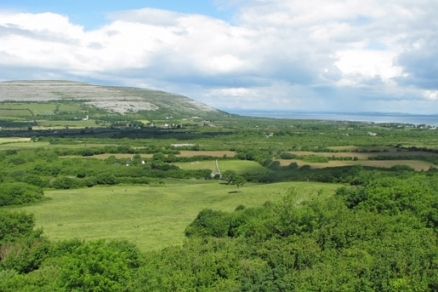
North Atlantic moist mixed forests, fragmented by farming, Burren, Ireland. @ C.Michael Hogan
The ecoregions of Ireland are two in number, both of which are mixed forests. In present day these two forest types cover about one tenth of the land surface of Ireland, although as late as the middle Holocene, a much higher fraction of these lands were heavily forested. The two distinct forest regions are the (a) Celtic broadleaf forests and (b) North Atlantic moist mixed forests.
Politically, at the present day, Ireland is divided under two governments: the Republic of Ireland in the south; and the United Kingdom in the north. For the purpose of this article on the ecoregions of Ireland, the subject landmass of consideration is the entirety of the island of Ireland, thus including the summation of its two different national political jurisdictions.
In phytogeographic parlance, both of Ireland's ecoregions lie within the Atlantic European province of the circumboreal region, and considered in the Boreal Kingdom.
Contents
Celtic broadleaf forests
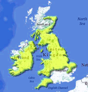 Celtic broadleaf forests in the British Isles. WWF
The Celtic broadleaf forests occupy the eastern and northeastern part of Ireland; as well as the majority of Wales; extreme southwest of England, central and northern England; and the south of Scotland extending along the North Sea coast through most of Aberdeenshire and Morayshire.
The climate of this ecoregion is generally mild, but associated with a large percentage of precipitation days and persistently high dampness. Climate in this palearctic region is tempered by the presence of the Gulf Stream lapping at the west of the British Isles.
n terms of native vertebrates there are a total of 257 recorded species in the Celtic broadleaf forests ecoregion. It is not surprising that there are no endemic vertebrates in the ecoregion, since all vertebrate taxa here populated the region by migration from the European continent only since glacial melting following the close of the most recent Ice Age, roughly 10,000 years before present.
Threatened non-endemic mammalian taxa in the ecoregion are: the Near Threatened Bechstein's bat (Myotis bechsteinii), the Near Threatened European otter (Lutra lutra)and the Near Threatened western barbastelle (Barbastella barbastella). There is a single special status non-endemic native reptile of the Celtic broadleaf forests: the Lower Risk grass snake (Natrix natrix).
North Atlantic moist mixed forests
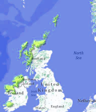 North Atlantic moist mixed forests. Note tiny outlier on Norway coast. WWF
The North Atlantic moist mixed forests ecoregion is a palearctic ecological unit lying in the west of Ireland and northwest of Scotland. The terrestrial extent of this ecoregion is approximately 14,900 square miles.
Prehistorically this ecoregion exhibited a rich forestation, including abundant Scots pine and yew, along with broadleaf species such as oak, ash, birch, hazel and alder. Significant deforestation occurred beginning in the Bronze Age and culminating in the late medieval times. The present condition of this ecoregion is one of considerable habitat loss, with an estimated 88 to 90 percent of the primordial forest destroyed; moreover, great damage has been carried out from the habitat fragmentation of clearfelling and planting of alien species conifer plantations.
There are 211 recorded native vertebrate species in the North Atlantic moist mixed forests, according the World Wildlife Fund; however, a full accounting of migratory bird species brings this number considerably higher. There is no endemism among the vertebrates of this ecoregion, a circumstance not surprising in that all such fauna migrated from the European continent since the last glacial retreat circa 10,000 years ago. Native mammals in the North Atlantic moist mixed forests, which are of special status but non-endemic are represented by one taxon: the Near Threatened European otter (Lutra lutra).
Context
Ecoregions are areas that: [1] share a large majority of their species and ecological dynamics; [2] share similar environmental conditions; and, [3] interact ecologically in ways that are critical for their long-term persistence. Scientists at the World Wildlife Fund (WWF), have established a classification system that divides the world in 867 terrestrial ecoregions, 426 freshwater ecoregions and 229 marine ecoregions that reflect the distribution of a broad range of fauna and flora across the Earth.
References
- Udo Bohn, Gisela Gollub and Christoph Hettwer. 2000. Reduced general map of the natural vegetation of Europe. 1:10 million. Bonn-Bad Godesberg 2000.
- M.J.Costello and K.S.Kelly. 1993. Biogeography of Ireland: past, present and future. Irish Biogeographic Society Occasional Publications Number 2
- J.R.Cross. 2006. The potential natural vegetation of Ireland. Biology and Environment 106B, 65-116.
- S.D.Davis, V.H.Heywood, and A.C.Hamilton. 1994. Centres of plant diversity. Vol. 1: Europe, Africa, Southwest Asia and Middle East. WWF and IUCN, Washington DC.
- Digital Map of European Ecological Regions (DMEER), Version 2000/05
- J.I.Dupouey, E.Dambrine., J.D.Laffite and C.Moares. 2002. Irreversible impact of past land use on forest soils and biodiversity. Ecology 83, 2978-2984.
- J.A.Fossitt. 2000. A Guide to Habitats in Ireland. Heritage Council, Kilkenny. ISBN: 1901137279.
- H.Heinzel, R.Fitter and J.Parslow. 1977. Pareys Vogelbuch - Alle Vögel Europas, Nordafrikas und des mittleren Ostens. Aufl. Verl. P. Parey, Hamburg, Berlin.
- D.Stanners and P.Bourdeau, editors. 1995. Europe's environment: The Dobris assessment. European Environment Agency, Copenhagen.
- World Wildlife Fund. 2010. North Atlantic moist mixed forests ecoregion delineation