North Atlantic moist mixed forests
The North Atlantic moist mixed forests ecoregion is a palearctic ecological unit lying in the west of Ireland and northwest of Scotland, along with a very small patch of coastal Norway. The terrestrial extent of this ecoregion is approximately 14,900 square miles.
Prehistorically this ecoregion exhibited a rich forestation, including abundant Scots pine and yew, along with broadleaf species such as oak, ash, birch, hazel abd alder. Significant deforestation occurred beginning in the Bronze Age and culminating in the late medieval times. The present condition of this ecoregion is one of considerable habitat loss, with an estimated 85 to 90 percent of the primordial forest destroyed; moreover, great damage has been carried out from the habitat fragmentation of clearfelling and planting of alien species conifer plantations.
Contents
Location and general description
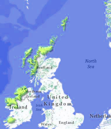
 North Atlantic moist mixed forests. Note tiny outlier on Norway coast. WWF In phytogeographic parlance, this ecoregion is part of the Atlantic European province of the Circumboreal Region in the Boreal Kingdom. The North Atlantic moist mixed forests span a considerable distance stretching from the south of Ireland through western Scotland, the far north of Scotland and even a tiny patch on the southwestern coast of Norway.
A major part of the ecoregion extends over the western mainland coast of Scotland carrying north from the Morvern Peninsula; moreover, this western Scotland element includes most of the Inner and Outer Hebrides, and some small disjunct mainland patches slightly south of Oban; this western Scotland element is carved up by the Sea of the Hebrides. The northern Scotland elements include the far north mainland and most of the Orkney and Shetland Islands.
On the island of Ireland, the North Atlantic moist mixed forests include the far northwest of Ireland including the northernmost part of the Republic of Ireland as well as the northwestern-most element of Northern Ireland. Southward the ecoregion extends to the southerly portion of Donegal Bay, but also includes a significant disjunctive southwest coastal patch that extends into much of Ulster.
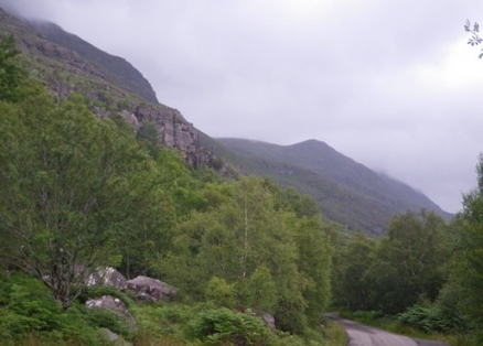
The Scottish island interiors within the ecoregion are frequently dominated by blanket bogs where peat is the prominent edaphic feature, rather than mineral generated soil. This peaty organic matter usually sits directly atop bedrock, such that rock outcrops are also a common feature of these islands; furthermore, there are many restricted flora that are well adapted to these peaty edaphic conditions. Stabilised sand dune grasslands are often found close to the Sea of the Hebrides or the open Atlantic.
Biodiversity
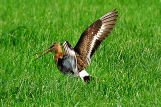
 Near Threatened black-tailed godwit. Source: Berend Jan Stijf There are 211 recorded native vertebrate species in the North Atlantic moist mixed forests, according the World Wildlife Fund; however, a full accounting of migratory bird species brings this number considerably higher. There is no endemism among the vertebrates of this ecoregion, a circumstance not surprising in that all such fauna migrated from the European continent since the last glacial retreat circa 10,000 years ago.
Native mammals in the North Atlantic moist mixed forests, which are of special status but non-endemic are represented by one taxon: the Near Threatened European otter (Lutra lutra).
Native but non-endemic threatened avian species occurring in this ecoregion are: the Near Threatened black-tailed godwit (Limosa limosa), the Near Threatened European curlew (Numenius arquata) and the Near Threatened sooty shearwater (Puffinus griseus).
Protected areas
The following is a partial list of protected areas within the North Atlantic moist mixed forests:
- Akeragh, Banna and Barrow Harbour, County Kerry, Republic of Ireland
- Ardboline Island and Horse Island, County Sligo, Republic of Ireland
- Bellanagare Bog, County Roscommon, Republic of Ireland
- Cross Lough, Country Mayo, Republic of Ireland
- Drumcliff Bay, County Donegal, Republic of Ireland
- Glenveagh National Park, County Donegal, Republic of Ireland
- Kerry Head, County Kerry, Republic of Ireland
- Lough Nillan Bog, County Donegal, Republic of Ireland
- Muckish Mountain, County Donegal, Republic of Ireland
- Staffa, Inner Hebrides, Argyll and Bute, Scotland
- Termoncarragh Lake and Annagh Machair, Country Mayo, Republic of Ireland
Prehistory
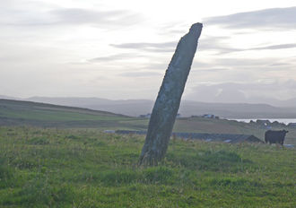
 Gartacharra standing stone, Islay, Scotland. @ C.Michael Hogan This region is relatively young with regard to human settlement, due to glaciation during the most recent Ice Age. Mesolithic peoples were certainly in evidence circa 9000 to 8000 years ago throughout the present day Irish portion of the ecoregion, as well as somewhat later in the western Scotland areas of the North Atlantic moist mixed forests. Neolithic farming ensued, as grain farming technologies developed, along with advancing forms of livestock tending, along with appearance of some of the early Neolithic and Bronze Age archaeological monumental sites in the region including standing stones and stone circles.
Status and threats
The present condition of this ecoregion is one of considerable habitat loss, with an estimated 85 to 90 percent of the primordial forest destroyed; moreover, great damage has been carried out from the habitat fragmentation of clearfelling and planting of alien species conifer plantations. While ongoing deforestation of native stands have largely been halted, there is an opportunity loss that continues, especially in Scotland, with widespread replanting of alien species conifer plantations, where native mixed forests once grew. The North Atlantic moist mixed forests ecoregion is classified as Vulnerable by the World Wildlife Fund.
Justification of ecoregion delineation
The North Atlantic moist mixed forests is an equivalent ecoregion to that unit set forth by the DMEER with the identical name. Ecoregion boundaries are chiefly an outcome of the DMEER delineation protocol; moreover, the North Atlantic mixed forests includes floodplain flora and moist lowland forests, lowland to submontane acidophilous oak and mixed oak forests, and ombrotrophic bogs of northwestern Ireland and western Scotland.
See also
References
- Udo Bohn, Gisela Gollub and Christoph Hettwer. 2000. Reduced general map of the natural vegetation of Europe. 1:10 million. Bonn-Bad Godesberg 2000.
- M.J.Costello and K.S.Kelly. 1993. Biogeography of Ireland: past, present and future. Irish Biogeographic Society Occasional Publications Number 2
- S.D.Davis, V.H.Heywood, and A.C.Hamilton. 1994. Centres of plant diversity. Vol. 1: Europe, Africa, Southwest Asia and Middle East. WWF and IUCN, Washington DC.
- Digital Map of European Ecological Regions (DMEER), Version 2000/05
- D.Stanners and P.Bourdeau, editors. 1995. Europe's environment: The Dobris assessment. European Environment Agency, Copenhagen.
- World Wildlife Fund. 2010. North Atlantic moist mixed forests ecoregion delineation
