Eastern highlands moist deciduous forests
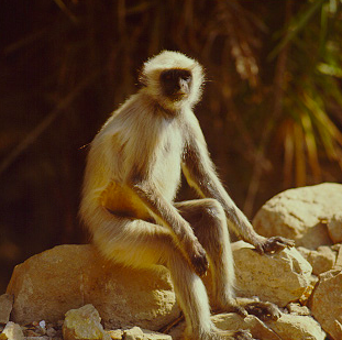
Hanuman langur (Semnopithecus entellus) Photograph by Edward Mendell
Introduction The Eastern Highlands Moist Deciduous Forests are considered globally outstanding for the large vertebrate assemblages and intact ecological processes they still support. The ecoregion (Eastern highlands moist deciduous forests) still retains large blocks of habitat that are more than 5,000 (km2). These are essential for the long-term conservation of the megavertebrates of Asia and are now a limited ecological resource.
 Near Bubaneshwar, India. (Photograph by Vasundhara) The complex landform coupled with the monsoon rains that sweep in from the Bay of Bengal also make this ecoregion an ice age refuge for elements of the moist forest flora from the faraway Western Ghats mountains and from the Eastern Himalayas. It is also a present-day refuge for many of the bioregion's large vertebrates, such as tigers (Panthera tigris), wolves (Canis lupus), gaur (Bos gaurus), and sloth bear (Melursus ursinus), that are increasingly confined to fragments of the natural habitat that once covered vast expanses of the Indian Subcontinent. Unfortunately Asia's largest terrestrial vertebrate, the Asian elephant (Elephas maximus), has already been extirpated from this ecoregion.
Location and General Description
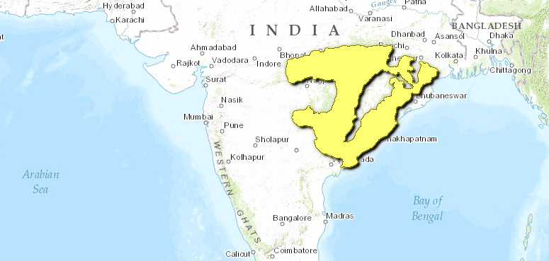
This expansive ecoregion represents the moist deciduous forests along the low hills of the northern sections of the Eastern Ghats Range of Andhra Pradesh and the eastern parts of the Satpura Range in Madhya Pradesh, India. These hills rise above 1,300 meters and mark the northern boundary of the Indian Peninsula. They also provide some relief to the otherwise featureless, flat Deccan Plateau. The ecoregion also extends across several other Indian states, including Bihar and Orissa. Geologically, it dates back to the Cretaceous and has Gondwanaland origins.
 WWF The low Eastern Ghats Mountains along the peninsula's eastern coast are not as effective in trapping the moisture from the monsoon winds that sweep in from the Bay of Bengal. Thus, this ecoregion receives about 1,000 meters of rainfall, which is about four times as much precipitation as falls in the drier areas to the west, lying in the rainshadow of the much higher and steeper Western Ghats Mountains.
The Eastern Ghats have biogeographic affinities with the eastern Himalayas and with the Western Ghats. The typical Himalayan species include Arisaema tortuosum, Elatostemma cuneatum, Didymocarpus pygmaea, Rubus ellpiticus, Thalictrum foliolosum, Boehmeria macrophylla, and Zanthoxylum rhetsa. Species with Western Ghats affinities include Schefflera venulosa, Artocarpus integrifolia, Gnetum ula, and Calamus rotang. These relict formations along with their floral and faunal communities suggest that this ecoregion once formed an important dispersal route for species between the Western Ghats and the Eastern Himalayas. This is contrary to the Satpura hypothesis put forth by Hora, who suggested that the dispersal bridge was the Satpura Range rather than the Eastern Ghats.
The hill forest vegetation is influenced by topography, soil, and precipitation, including microclimatic moisture regimes manifested by the complex landform. Gaussen et al. identified four vegetation types in this region: Shorea-Terminalia-Adina series, Shorea-Syzygium operculatum-Toona series, Shorea-Buchanania-Cleistanthus series, and Terminalia-Anogeissus-Cleistanthus series. The forests growing on the lateritic and crystalline rock substrates along the hills are dominated by Shorea robusta in association with Syzygium cumini, Dendrocalamus strictus, Phoenix acaulis, and Themeda quadrivalvis. On undulating hills in Madhya Pradesh, Terminalia tomentosa, Anogeissus latifolia, Pterocarpus marsupium, Madhuca indica, and Lagerstroemia parviflora become part of the association. Bamboos, especially Dendrocalamus strictus, grow in the undergrowth. The riverbanks are lined with Bambusa arundinaria.
Biodiversity Features
The Eastern Highlands Moist Deciduous Forests harbor intact assemblages of the large vertebrates of the Indian Subcontinent bioregion's tropical moist forests. Because the ecoregion still retains about 84,000 (km2) of intact habitat (representing about 25 percent of its area) in several large habitat blocks, it represents a rare opportunity to create large conservation landscapes that can support viable populations of species that need large spaces, such as tigers. Wikramanayake et al. recognized these forests as a high-priority TCU.
Although its intact habitat makes an important contribution to conservation, the ecoregion does not harbor high levels of endemism. The only ecoregional endemic mammal is a threatened Rhinolophidae bat, Hipposideros durgadasi (Table 1).
Table 1. Endemic and Near-Endemic Mammal Species. Family Species Rhinolophidae Hipposideros durgadasi But the mammal fauna includes a long list of threatened large vertebrates that includes the tiger, sloth bear (Melursus ursinus), wild dog (Cuon alpinus), gaur (Bos gaurus), chousingha (Tetracerus quadricornis), blackbuck (Antilope cervicapra), and chinkara (Gazella bennettii). A population (Eastern highlands moist deciduous forests) of the threatened wild water buffalo (Bubalus arnee) may still be living in Bastar District, Madhya Pradesh, near the junction of the Eastern Ghats Mountains and the eastern highlands. The 313 bird species known from the ecoregion include two threatened species: the green avadavat (Amandava formosa) and Pallas's fish-eagle (Haliaeetus leucoryphus). Botanically, this ecoregion contains several interesting and threatened species of conservation value, such as Arisaema tortuosum, Cyathea gigantea, Entada rheedii, Gnetum ula, Rauvolfia serpentina, Musa rosacea, Linociera ramiflora, Dioscorea anguina, Litsea monopetala, and Didymoplexis pallens and the endemic Leucas mukerjiana and Phlebophyllum jeyporensis. ==Current Status== 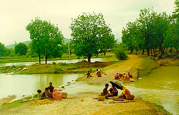 Near Bubaneshwar, India (Photograph by Vasundhara via WWF) About three-fourths of the natural forests of this ecoregion have been cleared. But unlike most of the other forested ecoregions in this bioregion, the remaining forests are in several large blocks that exceed 5,000 (km2). These extensive [[habitat]s] are important to conserve the large vertebrates in the region, and conservation actions should be directed to secure them from further fragmentation and degradation. The thirty-one protected areas in the ecoregion cover more than 13,500 (km2), or about 4 percent of the ecoregion's intact habitat (Table 2). Despite the large number of protected areas, few are large enough to meet the ecological needs of one of the ecoregion's important focal species, the tiger. The largest protected area, Simlipal, is just over 2,000 (km2), and Kawal and Indravati are just over 1,000 (km2). Kanha, one of the most important tiger reserves in India, is just under 1,000 (km2). But twenty-three of the thirty-one reserves are less than 500 (km2) in extent. {| border="1" cellpadding="3" align="left" ! colspan="3" align="center" | Table 3. Protected Areas that Overlap with the Ecoregion. Protected Area Area (km2) ICUN Category Kolleru 480 IV Kawal 1,080 IV Indravati 1,150 II Pranahita 130 IV Bhairamgarh 160 IV Lanjamadugu 80 DE Eturnagaram 120 IV Pamed 60 IV Pakhal 120 IV Balimela 130 DE Kondakameru 400 DE Kinnerasani 290 IV Papikonda 530 IV Achanakmar 550 IV Kanha 900 II Phen 100 IV Sitanadi 670 IV Udanti 340 IV Pachmarhi 500 IV Satpura 490 II Bori 460 IV Barnawapara 240 IV Mahuadaur 60 IV Badalkhol 120 IV Simlipal 2,550 IV Hadgarh 140 IV Satkosia Gorge 790 IV Baisipalli 170 IV Kotgarh 400 IV Karlapat 150 IV Kakhari Valley 180 IV Total 13,540 (Eastern highlands moist deciduous forests) ==== ==== ==== ==== ==== ==== ==== ==== ==Types and Severity of Threats== The primary threats to these remaining habitat blocks stem from quarries, coal mines, large-scale clearing for agriculture, and hydroelectric projects. Shifting (podu) cultivation and excessive dependence of the local communities on the nontimber forest products, especially in the northern parts of Andhra Pradesh, have also begun to degrade the ecological integrity of the forests. Organized timber thieves also operate in this ecoregion, illegally felling trees in remaining forests. The Naxalite movements and ongoing conflicts prevent effective conservation and management actions. ==Justification of Ecoregion Delineation== In previous analyses of conservation units of the Indian subcontinent, Rodgers and Panwar and MacKinnon divided the Deccan Peninsula into five biotic provinces, with each unit including several different vegetation types ranging from moist deciduous forests to dry forests to thorn scrub. The moist deciduous forests of the Eastern Ghats and Satpura Range were included in the Central Plateau North, Eastern Highlands, and Central Highlands biotic provinces by Rodgers and Panwar. In keeping with our definition of an ecoregion (i.e., an ecosystem of regional extent) and following our rules for ecoregion delineation (representing distinct vegetation types of regional extent in separate ecoregions), we placed the these moist deciduous forests in the Eastern Highlands Moist Deciduous Forests. We used MacKinnon's map of the original habitat to identify the ecoregion boundaries. ==Additional Information on this Ecoregion== * For a shorter summary of this entry, see the WWF WildWorld profile of this ecoregion. * To see the species that live in this ecoregion, including images and threat levels, see the WWF Wildfinder description of this ecoregion. * World Wildlife Fund Homepage Near Bubaneshwar, India (Photograph by Vasundhara via WWF) About three-fourths of the natural forests of this ecoregion have been cleared. But unlike most of the other forested ecoregions in this bioregion, the remaining forests are in several large blocks that exceed 5,000 (km2). These extensive [[habitat]s] are important to conserve the large vertebrates in the region, and conservation actions should be directed to secure them from further fragmentation and degradation. The thirty-one protected areas in the ecoregion cover more than 13,500 (km2), or about 4 percent of the ecoregion's intact habitat (Table 2). Despite the large number of protected areas, few are large enough to meet the ecological needs of one of the ecoregion's important focal species, the tiger. The largest protected area, Simlipal, is just over 2,000 (km2), and Kawal and Indravati are just over 1,000 (km2). Kanha, one of the most important tiger reserves in India, is just under 1,000 (km2). But twenty-three of the thirty-one reserves are less than 500 (km2) in extent. {| border="1" cellpadding="3" align="left" ! colspan="3" align="center" | Table 3. Protected Areas that Overlap with the Ecoregion. Protected Area Area (km2) ICUN Category Kolleru 480 IV Kawal 1,080 IV Indravati 1,150 II Pranahita 130 IV Bhairamgarh 160 IV Lanjamadugu 80 DE Eturnagaram 120 IV Pamed 60 IV Pakhal 120 IV Balimela 130 DE Kondakameru 400 DE Kinnerasani 290 IV Papikonda 530 IV Achanakmar 550 IV Kanha 900 II Phen 100 IV Sitanadi 670 IV Udanti 340 IV Pachmarhi 500 IV Satpura 490 II Bori 460 IV Barnawapara 240 IV Mahuadaur 60 IV Badalkhol 120 IV Simlipal 2,550 IV Hadgarh 140 IV Satkosia Gorge 790 IV Baisipalli 170 IV Kotgarh 400 IV Karlapat 150 IV Kakhari Valley 180 IV Total 13,540 (Eastern highlands moist deciduous forests) ==== ==== ==== ==== ==== ==== ==== ==== ==Types and Severity of Threats== The primary threats to these remaining habitat blocks stem from quarries, coal mines, large-scale clearing for agriculture, and hydroelectric projects. Shifting (podu) cultivation and excessive dependence of the local communities on the nontimber forest products, especially in the northern parts of Andhra Pradesh, have also begun to degrade the ecological integrity of the forests. Organized timber thieves also operate in this ecoregion, illegally felling trees in remaining forests. The Naxalite movements and ongoing conflicts prevent effective conservation and management actions. ==Justification of Ecoregion Delineation== In previous analyses of conservation units of the Indian subcontinent, Rodgers and Panwar and MacKinnon divided the Deccan Peninsula into five biotic provinces, with each unit including several different vegetation types ranging from moist deciduous forests to dry forests to thorn scrub. The moist deciduous forests of the Eastern Ghats and Satpura Range were included in the Central Plateau North, Eastern Highlands, and Central Highlands biotic provinces by Rodgers and Panwar. In keeping with our definition of an ecoregion (i.e., an ecosystem of regional extent) and following our rules for ecoregion delineation (representing distinct vegetation types of regional extent in separate ecoregions), we placed the these moist deciduous forests in the Eastern Highlands Moist Deciduous Forests. We used MacKinnon's map of the original habitat to identify the ecoregion boundaries. ==Additional Information on this Ecoregion== * For a shorter summary of this entry, see the WWF WildWorld profile of this ecoregion. * To see the species that live in this ecoregion, including images and threat levels, see the WWF Wildfinder description of this ecoregion. * World Wildlife Fund Homepage |
|---|
1 Comment
Glen Godfrey wrote: 10-20-2010 22:22:26
Eastern Ghats are discontinuous mountain ranges located along the eastern coastline of Indian Peninsular bordering Bay of Bengal. These mountain ranges extend from the deltaic parts of Mahanadi River in Orissa right down to Tamil Nadu in the south and also partially in Karnataka. Hills like Pachaimalai, Kalrayan, Palamalai, Mettur and Shevaroy in northern Tamil Nadu are some of the higher elevations of the Eastern Ghats in this area. http://www.travelindia360.net/eastern-ghats-hill-stations-and-wildlife-sanctuaries.html