Dardanelles
| Topics: |
This content is not assigned to a topic
|
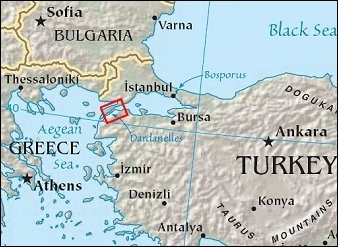
The Dardanelles (formerly known as the Hellespont) is a 38 mile (61 km) long waterway that links the Sea of Marmara (and through the Bosporus Strait, the Black Sea) with the Aegean and Mediterranean (Mediterranean Sea) Seas. The Dardanelles is 0.75 miles (1.2 km) wide at its narrowest point near the town of Çanakkale.
Together with the Bophosrus, the Dardanelles forms the Turkish Straits which separates the European part of Turkey from its Asian part. The Strait has a long history of strategic importance as it provides a conduit between the Mediterranean and Black Seas, as well as access to Istanbul to the northeast.The strait is a major conduit for maritime trade and is an oil transit chokepoint.
The peninsula on the European side of the strait is known as the Gallipoli Pensinsula after the town of the same name located near the entrance to the Sea of Marmara. This was the site a major military campaign during World War I (1915)

Contents
Geography
The strait is a 61-kilometer-long drowned valley formed along a fault (fracture in Earth’s crust). The fracture formed as the Arabian, Indian, and African tectonic plates collided with the Eurasian plate during the Tertiary period, approximately 2-65 million years ago. This faulting created the rugged terrain of western Turkey visible in the lower half of the photographs below, as well as the great mountain ranges of the Alps and Himalayas. Plate collision continues today as Turkey moves westward in relation to Eurasia. The movement leads to frequent strike-slip earthquakes (quakes in which the relative ground motion along the fault is forward or backward, rather than up or down.)
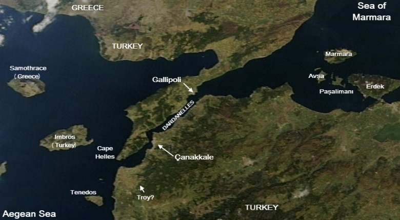
Source: Earth Snapshot. Image taken March 9, 2011
The peninsula on the European side of the strait is known as the Gallipoli Pensinsula after the town of the same name(Turkish: Gelibolu) located near the entrance to the Sea of Marmara.
Water in the Strait flows in both northeast and southwest directions due to opposite surface and undercurrents. The surface current frows southwest from the Sea of Marmara to the Aegean. The undercurrent flows northeast from the Aegean to the Sea of Marmara.
Oil transportation in the Dardenelles
Increased oil exports from the Caspian Sea region make the Turkish Straits one of the busiest and most dangerous chokepoints in the world supplying Western and Southern Europe.
An estimated 2.9 million barrels per day (bbl/d) flowed through the Bosorus and Dardelles in 2010, almost all of which was crude oil. The ports of the Black Sea are one of the primary oil export routes for Russia and other former Soviet Union republics. Oil shipments through the Turkish Straits decreased from over 3.4 million bbl/d at its peak in 2004 to 2.6 million bbl/d in 2006 as Russia shifted crude oil exports toward the Baltic ports. Traffic through the Straits increased again as crude production and exports from Azerbaijan and Kazakhstan rose in recent years.
With 50,000 vessels, including 5,500 oil tankers, passing through the straits annually it is also one of the world's busiest chokepoints.
Turkey has raised concerns over the navigational safety and environmental threats to the Straits. Commercial shipping has the right of free passage through the Turkish Straits in peacetime, although Turkey claims the right to impose regulations for safety and environmental purposes. Bottlenecks and heavy traffic also create problems for oil tankers in the Turkish Straits. While there are no current alternate routes for westward shipments from the Black and Caspian Sea region, there are several pipeline projects in various phases of development underway.
Under the Montreux Convention of 1936, commercial shipping has the right of free passage through the Straits in peacetime, although Turkey claims the right to impose regulations for safety and environmental purposes.
History
The name is drawn from the Dardanus, the son of Zeus and Electra, in Greek mythology or from a city that this mythological person created.
The Turkish name for the Dardanelles is Çanakkale Boğazı, or Çanakkale Strait, after the town of Çanakkale on the southern coast of the strait.
The former name, Hellespont, is drawn from the Greek “Sea of Helle” after a mythological woman who drowned in the strait.
The region of the Dardanelles has long been settled. The archeologial site of Hisarlık, located near the western (Aegean) end of the strait, has had settlements dated back to 3000–2600 BC. Hisarlik's city during the period 1300–1190 BC has been associated with the city of Troy described in Homer's Illiad.
The Gallipoli Peninsula was known as Thracian Chersonese (Chersonese being a Greek term for a peninsula), a part of the larger region of ancient Thrace, and its people known as Thracians.
The Greek Historian Herodotus (c. 484 – 425BC) described how the Persian King, Xeres I, built two pontoon bridges across the Dardanelles (then known by its Green name of the Hellespont) north of Çanakkale about 480 BC in order to invade ancient Greece. 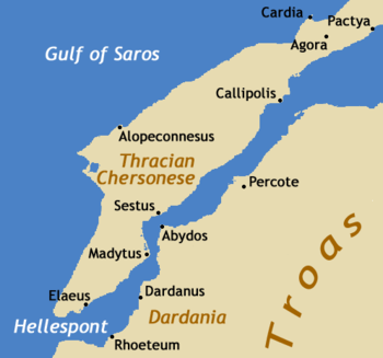 Source: Wikimedia Commons
They then began to build bridges across the Hellespont from Abydos to that headland between Sestus and Madytus, the Phoenicians building one of ropes made from flax, and the Egyptians building a second one out of papyrus. From Abydos to the opposite shore it is a distance of almost two-thirds of a mile. But no sooner had the strait been bridged than a great storm came on and cut apart and scattered all their work.
Xerxes flew into a rage at this, and he commanded that the Hellespont be struck with three hundred strokes of the whip . . .
. . . other builders were chosen. The bridging was done in the following way: fifty-oared ships and triremes were set side by side, about three hundred and sixty to form the Euxinian bridge, and about three hundred and fourteen to form the other bridge, . . .
Excerpted from translation by Richard Hooker
Fifty years later (334 B.C.), Alexander the Great and his army crossed the Dardanelles/Hellespont at close to the same location to begin his conquest of the Persian Empire.
After Greece became part of the larger Roman Empire, the area became part of the eastern Roman Empire known as Byzantium, which in turn became part of the Ottoman Turkey in the 14th century. The Ottoman ruler, Mehmet IV (1642 – 1693) built two forts, Kum Kale and Seddul el Bahr (Seddulbahir), on the Asian and European sides of the Dardanelles at the Aegean entrance of the strait.
In 1915, the Allies undertook a major campaign against Turkey (Allied with the Central Powers, including Germany) with nearly half-a-million troops from various parts of the British Empire, and 80,000 French. The Allies became trapped on the beaches of the Gallipoli Peninsula and, after ten months of fighting and nearly 200,000 casualties, withdrew - a major defeat for the Allies. One of the leading Turkish commanders was Mustafa Kemal (1881–1938), who would later found and lead the modern Turkish Republic.
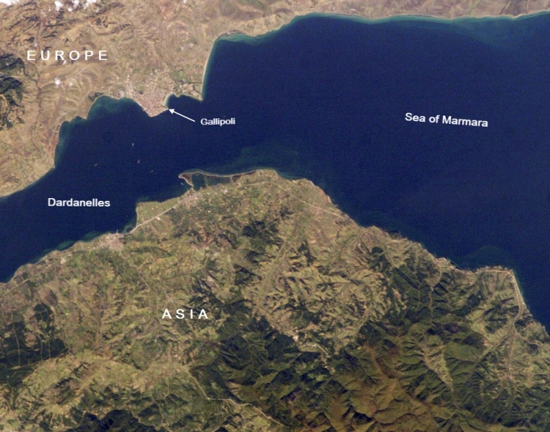
The city of Gallipoli (Gelibolu in Turkish) sits at a crossroads between the Marmara and Aegean Seas, connected by the Dardanelles Strait. The urbanized area of modern Gallipoli is visible as a light gray to pink region at the entrance to the Dardanelles Strait. Several ships are visible in the Strait to the southwest of Gallipoli (image center left). Source: NASA Earth Observatory, Astronaut photograph ISS014-E-8138 was acquired November 9, 2006
Sources and Further Reading
- Enegry Information Administration, 2013, Oil Transit Chokepoints
- NASA, 2007, Gallipoli and Dardanelles Strait, Turkey
- Hooker, R, Herodotus: The Histories: Xerxes at the Hellespont (mid 5th Century BCE) in Reading About the World: A Reader for the Study of World Civilizations, Vol. 1, 3rd edition, Harcourt Brace College Publishing: ISBN 0-15-567425-0
- Unietd States Hydrographic Office, 1920,The Black Sea pilot: the Dardanelles, Sea of Marmara, Bosporus, Black Sea, and Sea of Azov.
- Erickson, E.J. and Showalter, D., 2008, History of WWI: Gallipoli & The Middle East (From The Dardanelles To Mesopotamia), Amber Books, ISBN: 1906626154
Disclaimer: This article contains information that was originally published by, the Energy Information Administration. Topic editors and authors for the Encyclopedia of Earth may have edited its content or added new information. The use of information from the Energy Information Administration should not be construed as support for or endorsement by that organization for any new information added by EoE personnel, or for any editing of the original content.