Water profile of Azerbaijan
Contents
Geography and population
Azerbaijan (40°30' North, 47°30' East), located on the southeastern slopes of the Caucasus mountains, has a total area of 86,600 km2. It is bordered in the east by the Caspian Sea, in the south by Iran, in the southwest by Turkey, in the west by Armenia, in the northwest by Georgia and in the north by the Russian Federation. The Nakhchivan Autonomous Republic of Azerbaijan in the southwest is separated from the rest of the country by Armenia.
About 43% of the area of Azerbaijan is situated above 1,000 meters above sea level. Five main physiographic regions can be distinguished:
- The Greater Caucasus mountain range in the north, extending from the Black Sea in the west to the Caspian Sea in the east over the northern part of Georgia and Azerbaijan and the southern part of the Russian Federation;
- The Lesser Caucasus mountain range, south of the Greater Caucasus mountain range, covering the south of Georgia and Azerbaijan and the north of Armenia;
- The lowlands around the Kura and Araks rivers;
- The Talish mountains with the adjoining Lankaran lowland in the southeast along the border with Iran;
- The Nakhchivan Autonomous Republic in the southwest.
The cultivable area is estimated at about 4.32 million hectares (ha), which is 50% of the total area of the country. Almost all the land is shared between the sovkhoz (state farms) and the kolkhoz (collective farms). In 1993, the cultivated area was 1.80 million ha, or 42% of the cultivable area, of which 1.54 million ha were annual crops and 0.26 million ha permanent crops.
The total population is 7.6 million (1996), of which 44% is rural. The average population density is 88 inhabitants/km2. In 1996, agriculture employed 30% of the economically active population. Women make up about 36% of the rural labor force. The rural female labor force accounts for 48.5% of the total female labor force. The share of agriculture in gross domestic product (GDP) dropped from 39% in 1990 to 31% in 1995, due to the prevailing situation in the rural areas.
Climate and water resources
Climate
The climate in Azerbaijan is continental. Arid weather with average summer temperatures above 22°C is observed in the lowlands. In the mountain regions, temperatures can be below 0°C in winter and in Nakhchivan severe frost may occur. Humid tropical weather is observed in the coastal zone near the Caspian Sea, mainly in the Lankaran lowlands in the southeast. The average precipitation is estimated at 541 mm/year.
River basins and surface water resources
Four major river basins can be distinguished, two of which are international:
- The basin of the Kura and Araks rivers. It is by far the largest basin in the country. The Kura River rises in the Kars upland in northeast Turkey. It then flows into Georgia and crosses the border to Azerbaijan in the northwest. The total length of the Kura River system is 1,515 kilometer (km), of which 900 km is located within Azerbaijan. The total annual inflow from Georgia is estimated at 11.910 km3. The Araks River also rises in the northeast of Turkey. After forming the border between Turkey and Armenia, Turkey and Azerbaijan, Iran and Azerbaijan, Iran and Armenia, and Iran and Azerbaijan again, it flows into Azerbaijan in the east of the country. About 100 km downstream of the border it flows into the Kura River, which continues to flow southeast towards the Caspian Sea. The total annual inflow of the main Araks River is estimated at 6.724 km3. The total annual inflow of the tributaries of the Kura and Araks rivers coming from Armenia is estimated at 2.346 km3. The total inflow into Azerbaijan is thus estimated at 20.980 km3/year (does not include the areas located in the occupied zone and the zone declared neutral in May 1994).
- The Samur River basin. It is located in the northeast of the country. The Samur River rises in the Russian Federation and then forms the border between the Russian Federation and Azerbaijan with an annual discharge estimated at 2.36 km3, half of which is considered to be available for Azerbaijan. Before flowing into the Caspian Sea, the river divides into several branches.
- The coastal river basins in the northeast between the Samur and Kura river basins.
- The coastal river basins in the Lankaran region in the southeast, south of the Kura River basin.
The internally generated surface water resources are estimated at 5.955 km3/year. The total renewable surface water resources (RSWR), including incoming and bordering flows, are estimated at 28.115 km3/year. For the Kura and Araks rivers, which are shared between Turkey, Georgia, Armenia, Iran and Azerbaijan, discussions are underway on water sharing between the countries.
Groundwater resources
The internal renewable groundwater resources are estimated at 6.51 km3/year, of which 4.35 km3/year are common to surface water. The groundwater resources are famed for their quality as mineral drinking water and are also used for medical purposes. The Nakhchivan Autonomous Republic is especially rich in mineral groundwater. The total number of artesian wells is estimated at about 7,000 with a total discharge of about 2.1 million m3/year.
Lakes and dams
The total reservoir capacity of large dams (larger than 100 million m3 each) is estimated at 21.35 km3. The four largest reservoirs are the Minghachevir and Shamkir on the Kura River, the Nakhchivan on the Araks River, and the Sarsangh on the Terter River. The total capacity of smaller reservoirs for irrigation purposes is estimated at 100 million m3.
Water withdrawal and wastewater
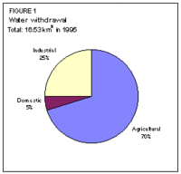
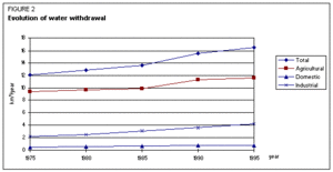
In 1995, the total water withdrawal for agricultural, domestic and industrial purposes was 16.53 km3, of which over 70% was used for agricultural uses and almost 25% for industrial purposes (Figure 1). On the Apsheron peninsula, where the capital Baku is located, the share of industrial water withdrawal is 70%. In 1975, the total water withdrawal was 12.14 km3, of which 77% was used for for agricultural uses and 19% for industrial purposes (Figure 2). The annual production of wastewater is about 571 million m3. Most wastewater is produced by industries like the cotton cleaning, cotton oil production, fish-curing and grape processing industries. It is estimated that 18% of the produced wastewater is treated, which is about 103 million m3/year or 280,000 m3/day.
Irrigation and drainage development
Irrigation development
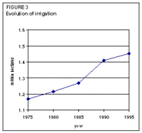
Based on soil and water resources, the irrigation potential is estimated at 1.72 million ha. In the last century, irrigation was concentrated alongside the rivers. At the beginning of this century, the construction of large irrigation canals started. In 1913, 582,000 ha were irrigated. The most intensive development took place after the Second World War. In 1975, the area equipped for irrigation was 1.17 million ha. In 1995, it was 1.45 million ha, which is 84% of the irrigation potential (Figure 3).
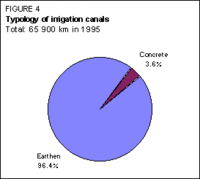
The total length of all irrigation canals is 65,900 km, of which only 2,400 km, or 3.6%, are concrete canals (Figure 4). Irrigation efficiency at national level is estimated at 55%. The largest canals are the Upper Garabakh, the Upper Shirvan and the Samur-Apsheron canals, all earthen. The Upper Gabarakh canal runs southeast from the Mingachevir reservoir to the Araks River. Its length is about 174 km and its capacity 113.5 m3/s. About 85,000 ha are irrigated from this canal. The Upper Shirvan canal also starts from the Mingachevir reservoir and runs east to the Akhsu River. Its length is about 126 km and its capacity 78 m3/s. About 91,100 ha are irrigated from this canal.
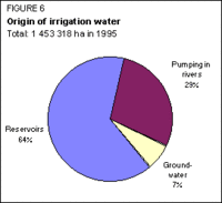
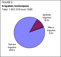
Almost 90% of the irrigation is surface irrigation, mainly furrow and borderstrip irrigation (Figure 5). Sprinkler irrigation and micro-irrigation are mainly used on perennial plantations and vineyards. Surface water is used on 93% of the area, mainly from reservoirs and through direct pumping in rivers and canals (Figure 6). About 96,700 ha are irrigated by groundwater through more than 5,000 wells. The power irrigated area is estimated at 511,000 ha.
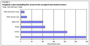
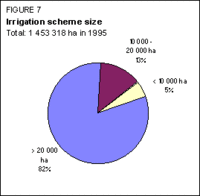
Over 80% of the schemes are larger than 20,000 ha (Figure 7). Most schemes are state-owned. Farmer-owned irrigation started to appear in 1992 and represented 1% of the area in 1996. Information on areas of irrigated crops refers only to part of the total area equipped for irrigation, as no information is available for the part of the country that is located in the disputed zone occupied by Armenia and in the zone declared neutral since May 1986. The main irrigated crops are wheat, cotton and barley, with average yields of 1.64, 1.30 and 1.68 t/ha respectively (Figure 9).
Salinity and drainage development
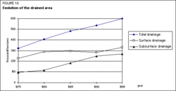
Out of the 1.45 million ha equipped for irrigation, 615,000 ha are subject to various degrees of salinity: 60 000 ha are salinized to a high degree, 124,000 ha to a medium degree, and 431,000 ha to a slight degree. The total length of the drainage network is 31,000 km, covering almost 600,000 ha in 1995, all in the areas equipped for irrigation (Figure 10). It is estimated that 350,000 ha of drained land need major rehabilitation.
Institutional environment
The main institutions involved in water resources management, all state institutions, are:
- The Committee of Land Improvement and Water Economy, in charge of land improvement activities and the operation and maintenance (O&M) of the infrastructure;
- `Azervodstroy', in charge of the construction of infrastructure;
- `Azselkhozvodosnabzheniye', in charge of agricultural water supply;
- `Azkomunpromvod' and the Committee of Domestic-Municipal Services, in charge of domestic water supply and the O&M of the sewage system;
- The Committee of Ecology and Nature Use, in charge of the monitoring of salinization and water resources pollution.
In July 1996, a land reform law was adopted by the National Assembly (Milli Majlis). This law establishes private property rights to land. The land is to be transferred to all rural inhabitants free of charge. It can then be sold freely, exchanged, transferred by right of succession, leased or used as mortgage.
A land improvement and irrigation law has also been adopted. This law establishes the legal basis of activities on land improvement and irrigation under the new landownership conditions and provides for the transition to paid water use.
Trends in water resources management
The rehabilitation of irrigation and drainage systems to ensure the sustainability of the irrigation subsector is a priority for the near future. Major policy changes in landownership and irrigation management are expected to play an important role in improving irrigation performance.
Erosion control is seen as another major issue. According to the data of the Ecological Committee, almost 43% of the country is subject to erosion. Effective measures to combat water erosion are the creation of a field protecting wood belt, as well as wood belts along the banks of large rivers, canals and reservoirs.
International issues of critical importance are the sharing and joint management of the Kura and Araks rivers and of the Caspian Sea to prevent further pollution (Water pollution) and ensure sustainable development of their resources.
Further Reading
- Water profile of Azerbaijan, Food and Agriculture Organization.
- World Factbook: Azerbaijan, Central Intelligence Agency.
- Aliyev, R.O. 1991. Hydraulic and land improvement constructions in conditions of pre-mountain plains. G.G. Morozovsckaya.
- Aliyev, A., Mirzakhanov, A., Mamedov, S., Mamedov, A. 1986. Draft of the scheme of development and accommodation of land improvement and water economy of the Azerbaijan Republic up to 2005.
- Badalova, S., Samedov, R., Safarov, H., Muradova, K. 1996. Land survey of the Azerbaijan Republic.
- Listengarten, V.A. 1987. Groundwater resources information. T.D. Kostin.
- Mamedov, R.G. and Ibadzade, Y.A. 1988. Water economy of Azerbaijan and development prospects. Sh. Rasizade.
- Ministry of Water Economy. 1985. Technical certification of the irrigated and water managed systems.
| Disclaimer: This article is taken wholly from, or contains information that was originally published by, the Food and Agriculture Organization. Topic editors and authors for the Encyclopedia of Earth may have edited its content or added new information. The use of information from the Food and Agriculture Organization should not be construed as support for or endorsement by that organization for any new information added by EoE personnel, or for any editing of the original content. |