Daily and annual cycles of temperature
Contents
Daily Cycles of Air Temperature
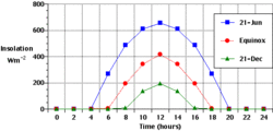
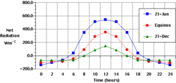
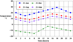
At the Earth's surface quantities of insolation and net radiation undergo daily cycles of change because the planet rotates on its polar axis once every 24 hours. Insolation is usually the main positive component making up net radiation. Variations in net radiation are primarily responsible for the particular patterns of rising and falling air temperature over a 24 hour period. Figures 1, 2, and 3 show hypothetical average curves of insolation, net radiation, and air temperature for a typical land-based location at 45° of latitude on the equinoxes and solstices.
In Figure 1, shortwave radiation received from the sun is measured in Watts. For all dates, peak reception occurs at solar noon when the sun attains its greatest height above the horizon.
Units in Figure 2 are the same as the insolation graph in Figure 1. The net radiation graph indicates that there is a surplus of radiation during most of the day and a deficit throughout the night. The deficit begins just before sunset when emitted longwave radiation from the Earth's surface exceeds solar insolation and longwave radiation from the atmosphere.
In Figure 3, the relative placement of the temperature profiles for the various dates correlates to the amount of net radiation available for daily surface absorption and heat generation. The more energy available, the higher up the Y-axis the profile is on the graph. Autumnal equinox (September 21) is warmer than the vernal equinox (March 21) because of the heating that occurred in the previous summer months. For all dates, minimum temperature occurs at sunrise. Temperature drops throughout the night because of two processes. First, the Earth's radiation balance at the surface becomes negative after sunset. Thus, the surface of the Earth stops heating up as solar radiation is not being absorbed. Secondly, conduction and convection transport heat energy up into the atmosphere (Atmosphere layers) and the warm air that was at the surface is replaced by cooler air from above because of atmospheric mixing. Temperature begins rising as soon as the net radiation budget of the surface becomes positive. Temperature continues to rise from sunrise until sometime after solar noon. After this time, mixing of the Earth's surface by convection causes the surface to cool despite the positive addition of radiation and heat energy.
Annual Cycle of Air Temperature
As the Earth revolves around the sun, locations on the surface may under go seasonal changes in air temperature because of annual variations in the intensity of net radiation. Variations in net radiation are primarily controlled by changes in the intensity and duration of received solar insolation (Earth-Sun relationships and insolation) which are driven by variations in daylength and angle of incidence. The discussion below examines how changes in net radiation can effect mean monthly temperatures for the following five locations:
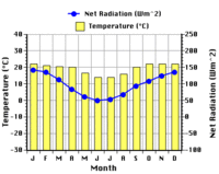
- Manaus, Brazil, 3° South latitude (Figure 4).
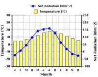
- Bulawayo, Zimbabwe, 20° South latitude (Figure 5).
- Albuquerque, USA, 35° North latitude (Figure 6).
- London, England, 52° North latitude (Figure 7).
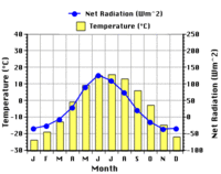
- Fairbanks, USA, 65° North latitude (Figure 8).
At Manaus, values of monthly net radiation average about 135 Watts per square meter. Monthly variation in net radiation is only about 35 Watts over the entire year (Figure 4). Two peaks in net radiation are visible on the graph. Both of these peaks occur during the equinoxes when the height of the sun above the horizon is at its maximum (90° above the horizon). Minimum values of net radiation correspond to the time of the year when the sun reaches its minimum height of only 66.5° above the horizon at solar noon. Because of the consistent nature of net radiation, mean monthly air temperature only varies by 2° Celsius over the entire year.
Net radiation at Bulawayo has a single peak and trough over the one year period graphed. This pattern is primarily controlled by variations in the intensity and duration of incoming solar insolation (Earth-Sun relationships and insolation) (Figure 5). During the winter solstice the sun reaches its highest altitude above the horizon and daylength is at a maximum (13 hours and 12 minutes). The lowest values of net radiation occur around the summer solstice when the sun reaches its lowest altitude above the horizon and daylength is at a minimum (10 hours and 48 minutes) in the Southern Hemisphere. Monthly temperature variations follow the monthly change in net radiation. Net radiation represents energy available to do work. When received at the Earth's surface much of this energy is used to create sensible heat.
At Albuquerque, maximum net radiation occurs in May. The timing of this peak roughly coincides with the summer solstice when daylengths are at their longest and solar heights are their greatest (Figure 6). However, monthly temperature variations do not mirror the changes in net radiation exactly. Peak monthly [[temperature]s] occur about two months after the net radiation maximum. This lag is probably caused by the delayed movement of stored heat energy in the ground into the atmosphere (Atmosphere layers). Minimum monthly temperatures do coincide with the lowest values of net radiation which occur during the winter solstice.
The annual patterns of net radiation and mean monthly temperature for London are quite similar to those already described for Albuquerque (Figures 6 and 7). London does, however, experience a greater annual variation in net radiation. This greater variation can be explained by the effect increasing latitude has on annual variations of insolation. During the winter months, outgoing longwave radiation actually exceeds incoming insolation producing negative net radiation values. This was not seen in Albuquerque. The variation in monthly mean temperature is also less extreme in London when compared to Albuquerque. Intuitively, one would expect London to have a greater annual change in temperature because of the greater variation in net radiation over the year. However, London's climate is moderated by the frequent addition of latent heat energy from seasonal precipitation.
Of the five locations examined, Fairbanks has the greatest variations in mean monthly temperature. Fairbanks is also the coldest of the climates examined (Figure 8). This is primarily due to the fact that during six months of the year net radiation is negative because outgoing longwave radiation exceeds incoming insolation. Fairbanks also receives the least cumulative amount of net radiation over the entire year. Mean monthly temperature is at its maximum in July which is one month ahead of the peak in net radiation.
