Mid-latitude cyclone
| Topics: |
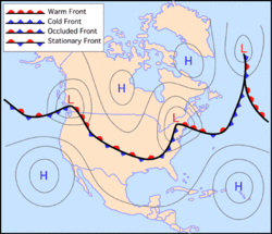
Mid-latitude or frontal cyclones are large traveling atmospheric cyclonic storms up to 2000 kilometers in diameter with centers of low atmospheric pressure. An intense mid-latitude cyclone may have a surface pressure as low as 970 millibars, compared to an average sea-level pressure of 1013 millibars. Normally, individual frontal cyclones exist for about 3 to 10 days moving in a generally west to east direction. Frontal cyclones are the dominant weatherevent of the Earth's mid-latitudes forming along the polar front (Figure 1).
Mid-latitude cyclones are the result of the dynamic interaction of warm tropical and cold polar air masses at the polar front. This interaction causes the warm air to be cyclonically lifted vertically into the atmosphere (Atmosphere layers) where it combines with colder upper atmosphere air. This process also helps to transport excess energy from the lower latitudes to the higher latitudes.
The mid-latitude cyclone is rarely motionless and commonly travels about 1200 kilometers in one day. Precise movement of this weather system is controlled by the orientation of the polar jet stream in the upper troposphere. An estimate of future movement of the mid-latitude cyclone can be determined by the winds directly behind the cold front. If the winds are 70 kilometers per hour, the cyclone can be projected to continue its movement along the ground surface at this velocity.
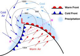
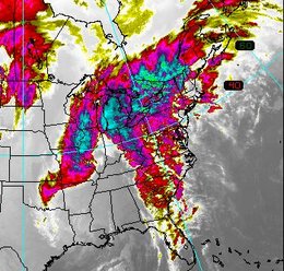
Figure 3 describes the patterns of wind flow, surface pressure, fronts, and zones of precipitation associated with a mid-latitude cyclone in the Northern Hemisphere. Around the low, winds blow counterclockwise and inwards (clockwise and inward in the Southern Hemisphere). West of the low, cold air traveling from the north and northwest creates a cold front extending from the cyclone's center to the southwest. Southeast of the low, northward moving warm air from the subtropics produces a warm front. Precipitation is located at the center of the low and along the fronts where air is being uplifted.
Mid-latitude cyclones can produce a wide variety of precipitation types. Precipitation types include: rain, freezing rain, hail, sleet, snow pellets, and snow. Frozen forms of precipitation (except hail) are common with storms that occur in the winter months. Hail is associated with severe thunderstorms that form along or in front of cold fronts during spring and summer months.
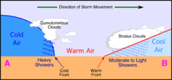
Figure 4 describes a vertical cross-section through a mature mid-latitude cyclone. In this cross-section, we can see how air temperature changes as we move from behind the cold front to a position ahead of the warm front. Behind the surface position of the cold front, forward-moving cold dense air causes the uplift of the warm lighter air in advance of the front. Because this uplift is relatively rapid along a steep frontal gradient, the condensed water vapor quickly organizes itself into cumulus and then cumulonimbus clouds. Cumulonimbus clouds produce heavy precipitation and can develop into severe thunderstorms if conditions are right. Along the gently sloping warm front, the lifting of moist air produces first nimbostratus clouds followed by altostratus and cirrostratus. Precipitation is less intense along this front, varying from moderate to light showers some distance ahead of the surface location of the warm front.
Frontal cyclone development is related to polar jet stream processes. Within the jet stream, localized areas of air outflow can occur because of upper air divergence. Outflow results in the development of an upper air vacuum. To compensate for the vacuum in the upper atmosphere (Atmosphere layers), surface air flows cyclonically upward into the outflow to replenish lost mass. The process stops and the mid-latitude cyclone dissipates when the upper air vacuum is filled with surface air.
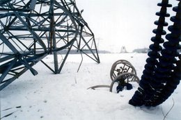
Mid-latitude cyclones cause far less damage than tropical cyclones or hurricanes. Hurricanes involve much greater amounts of atmospheric energy exchange. As one goes away from the equator, the energy available to fuel a weather system decreases as the amount of solar radiation and heat declines. Mid-latitude cyclones can have winds as strong as what is associated with a weak hurricane. But, this is a rare occurrence. Frontal cyclones tend to be most disruptive to human activity during winter months. Winter storms can produce heavy snowfalls or freezing rain which slows down transportation, snaps powerlines, and kills vegetation. In January 1998, a winter storm in eastern North America resulted in more than 20 human deaths, billions of dollars of damage, the loss of electrical power in some areas for up to two weeks, and the destruction of many deciduous trees because of the weight of ice (Figures 5 and 6).
Further Reading