Cordillera Oriental montane forests
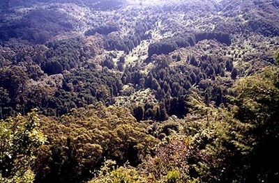
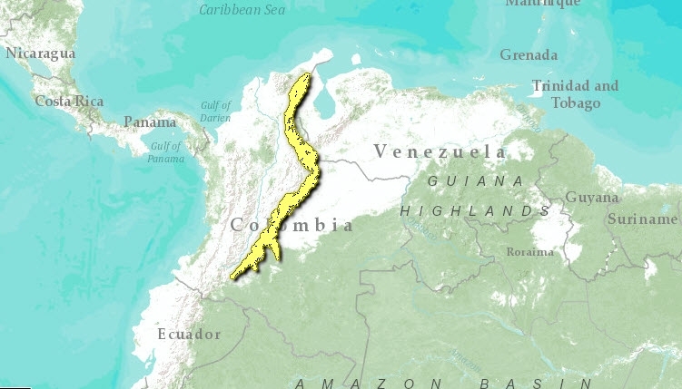
These Andean montane forests span the eastern slopes of the Andean Cordillera Oriental from their northernmost point southwards through most of Colombia. The Cordillera Oriental Montane Forests are clearly distinguishable from the rest of the montane forest ecoregions of the Northern Andes because of the influence of the piedmont dry forests and the Llanos grasslands of the Orinoco basin, as well as species associations shared with the isolated Santa Marta Mountains.
Location and General Description
With a significant change in latitude from north to south, this ecoregion has three major sub-ecoregions: the Perijá Mountains proper, the Northeastern slope of the Eastern Andes, and the Southeastern slope of the same range. The eastern slope is situated between the Tamá Massif at the border between Colombia and Venezuela and the Serranía de La Macarena. For around 300 kilometers(km), this ecoregion’s southern portion is narrow and low (reaching less than 3,000 meters). As it widens, it contains zones of altiplanos (high, flat plains) and extensive paramo, with several snow-covered peaks (such as the Sierra Nevada del Cocuy, at 5,493 meters).
Three life zones are represented within the ecoregion: premontane moist forest, montane forest proper, subalpine moist forest and, in some drier pockets, premontane dry forest, In the southern portion, lies moist piedmont forest, connected to the moist forests of the northwestern Amazon region. The eastern slopes of the Eastern Range within these montane forests descend steeply into zones of beginning transition to Amazonian wet forest in the southern portion of the Northern Andean ecoregions to the Llanos in the north. The isolated range of La Macarena reaches some 1,800 meters (m) in elevation and extends southeast from the Eastern Range in Colombia into the lowland wet forest. Geologically distinct from the Andes, this range is related to the isolated Table Mountains eastward and the Tepuis of the Guiana Shield and therefore contain Llanos and Amazonian, as well as Andean, floral elements.
Biodiversity Features
Species richness in this ecoregion is outstanding both at a regional and global level, due to high turnover rates in species composition. Current inventories for this ecoregion include 878 species of birds (18 endemic taxa), 169 species of frogs (32 endemic), and 63 species of palms (5 endemic). This ecoregion also holds populations of unique and threatened species such as the Andean condor (Vultur gryphu) and the spectacled bear (Tremarctos ornatus).
Depending on the taxonomic group studied, the Serranía de Perijá may display more similarity in species composition to the Sierra Nevada de Santa Marta an isolated highland ecoregion, than with the eastern slope of the Eastern Range. Of the 429 species of birds known from Perijá, 76% are shared with the Sierra Nevada de Santa Marta and a similar proportion is shared with the eastern slope. In two sub-families of butterflies, Ithomiinae and Heliconiinae, Perijá shares some 80% of species with the Sierra Nevada yet only 40% with the eastern slope of the main Andean range. Perijá contains a species grouping that is not present on the eastern slope of the cordillera.
The difference in species composition between the northeastern and southeastern slope, also depends on the taxonomic group studied. For example, while species composition of birds and certain plant groups (Arecaceae, Meliaceae) are highly similar in these two sub-ecoregions, there are few species of frogs and butterflies shared among them. Of the 41 species of frogs found on the northeastern slope, and the 43 on the southeastern slope, only 15 are found in both sub-ecoregions. Of the 53 species of the Satyrinae subfamily of butterflies are found in the northeastern slope and the 28 found in the southeastern slope, only 9 are found in both. In the Ithomiinae subfamily, the northeastern sub-ecoregion contains some 60 species and sub-species, and the southeastern some 78 species, but only 45 of these are shared.
Current Status
In Colombia, 60% of the original ecosystems of the ecoregion have been altered. In the montane forests of the Macarena Mountains around 17% has been intervened and approximately 60% of the area has been converted. In Venezuela, the degree of habitat loss (Land-use and land-cover change) is unknown but thought to be limited. However, extant remnants of the original vegetation of this ecoregion still cover about 4,733 km2. In Venezuela Perijá National Park covers some 3,000 km2 and there is a proposal to declare this zone as a biosphere reserve. In the Colombian portion of the ecoregion, Parque Catatumbo – Bari covers some 821 km2, and various indigenous territories cover another 1,746 km2.
Types and Severity of Threats
Logging, agriculture, and extensive ranching activities, such as in the flatter foothills, have led to fragmentation, while hydroelectric projects and road infrastructure are being developed in some areas continue to threaten the ecoregion. In Venezuela, livestock grazing and carboniferous mining have been traditional and continuing causes of habitat destruction (Land-use and land-cover change) and fragmentation. In the Amazonian foothills and the Macarena Mountains, colonization is occurring, bringing threats of agriculture and extensive grazing. New crops, such as rice, are being brought in to this ecoregion. Concentration of land elsewhere has caused colonization to stretch into this ecoregion. Intensive agriculture with agrochemicals occurs in some areas threatening water and soils with toxic (Toxicology) pollution.
Movements and colonization caused by political conflict, armed conflicts, and border restrictions, plus the world markets for illicit drugs, are relatively new threats to biodiversity conservation in the ecoregion. Poor soils and the difficulty of commercialization and transport of agricultural products make illegal crops an alternative this population. Forest clearing for these crops and their eradication through burning and chemical herbicides are among the main causes of habitat disturbance throughout these mountain ecosystems.
Nonetheless, current impact on biodiversity is apparently still low. In addition, both the strong indigenous presence - such as the U´wa and their recently expanded 200,000 hectares (ha) territory – and the recent cooperation initiative between [[Colombia]n] and [[Venezuela]n] governments for the enhancement of the trans-frontier parks and the creation of bi-national protected areas are significant opportunities for conservation.
Justification of Ecoregion Delineation
The deliniations for these montane forests were derived from vegetation maps of both Venezuela and Colombia. In the broadest sense, this ecoregion encompasses the forests between the lowland forests of the eastern slopes (1,000 m) and the continental divide (excluding páramo) of the Cordillera Oriental, from where it splits from the main Andean chain in southern Colombia, to where it terminates along the Venezuelan-Colombian border NW of Laker Maracaibo. Cordillera de Mérida was seperated from this ecoregion, as were all páramo habitats. Linework follows the the Huber and Alarcon classification of "evergreen ombrophilous submontane and montane forests", and Navarro et al’s classification of "piedmont montane forests"and "escarpment montane forests". We also included the Serrania de la Macarena as an extension of this ecoregion, as it shares more components with these montane forests than the surrounding lowland forests. All agriculture areas within the classification were lumped. This ecoregion has pronounced species richness, high species endemism, and distinct flora and fauna from all surrounding ecoregions. Linwork was reviewed at an ecoregional priority setting workshop.
Additional Information on this Ecoregion
- For a shorter summary of this entry, see the WWF WildWorld profile of this ecoregion.
- To see the species that live in this ecoregion, including images and threat levels, see the WWF Wildfinder description of this ecoregion.
- World Wildlife Fund Homepage
Further Reading
- Adams, M. J. and G. I. Bernard. 1979. Pronophiline butterflies (Satyridae) of the Serranía de Valledupar, Colombia-Venezuela border. Systematic Entomology (London), 4: 95-118.
- Arango, N. and M. E. Chavez, editors. 1997. Informe Nacional sobre el Estado de la Biodiversidad en Colombia. Instituto Alexander Von Humboldt; Ministerio del Medio Ambiente Departamento Nacional de Planeación PNUMA UICN. Santafé de Bogotá.
- Calchi, R. and A. Viloria. 1991. Occurrence of the Andean Condor in the Perijá Mountains of Venezuela. Wilson Bull., 103 (4): 720-722.
- Complejo Ecoregional de los Andes del Norte (CEAN). Experts and ecoregional priority setting workshop. Bogota, Colombia, 24-26, July, 2000.
- Corrales, E. 2000. Andes del Norte: Principales Tendencias Socioeconómicas y su Relación con la Biodiversidad. WWF-COP, Informe Técnico de consultoría.
- Espinal, L. S. and E. Montenegro. 1963. Formaciones vegetales de Colombia. Memoria explicativa sobre el mapa ecológico. Bogotá: Instituto Geográfico "Agustín Codazzi", Editorial Canal Ramírez, 201 p. + 1 mapa. En 1977.
- Ewel, J. J., A. Madriz and J. A. Tosi, Jr. 1968. Zonas de vida de Venezuela. Memoria explicativa sobre el mapa ecológico. Caracas: Ministerio de Agricultura y Cría, Editorial Sucre, 270 p. + 1 mapa 1: 2.000.000
- Fjeldså, J. and N. Krabbe. 1990. Birds of the High Andes. Zoological Museum, University of Copenhagen, Denmark. ISBN: 8788757161
- Gabaldón, M. 1992. Parques Nacionales de Venezuela. Sthephan y Thora Amend, editors. Serie Parques Nacionales y Conservación Ambiental. Nº 1. Fundación Banco Consolidado, Instituto Nacional de Parques (INPARQUES). Caracas, Venezuela. 120 pp.
- Goldstein, I. 1990. Distribución y Hábitos Alimentarios del Oso Frontino, Tremarctos ornatus, en Venezuela. Tesis M. Sc., Universidad Simón Bolívar, Caracas. 164 pp.
- Goldstein, I. 1993. Distribución, Presencia y Conservación del Oso Frontino en Venezuela. Biollania. 9: 171-181.
- Hilty, S. L., and W. L. Brown. (1986). A guide to the birds of Colombia. Princeton Univ. Press, Princeton, NJ. ISBN: 069108372X
- Huber, O., and C. Alarcon. 1988. Mapa de vegetación de Venezuela. 1:2,000,000.
- Ministerio del Ambiente y de los Recursos Naturales Renovables, Caracas, Venezuela.
- Kattan, G. 2000. Patrones ecorregionales de diversidad en los Andes del Norte. WWF-COP, Informe Técnico de consultoría.
- MARNR - Ministerio del Ambiente y de los Recursos Naturales Renovables- . 1983. Síntesis del Mapa de la Vegetación Actual de Venezuela. Proyecto VEN/79/001 Sistemas Ambientales Venezolanos. Editorial Arte. Caracas. 39 pp.
- MARNR. - Ministerio del Ambiente y de los Recursos Naturales Renovables-1982. Mapa de la Vegetación Actual de Venezuela. Proyecto VEN/79/001/B, Sistemas Ambientales Venezolanos. DGSIIA/DGSPOA. Escala 1:500.000. Versión Atlas.
- MARNR. - Ministerio del Ambiente y de los Recursos Naturales Renovables-1985. Atlas de la Vegetación de Venezuela. 1ra. Edición. Serie Informes Técnicos. DGSIIA/178. Imprenta de Cartografía Nacional. Caracas. 109 pp.
- Navarro, A.E.S., G.H. Peña, F.C. Lemus, J.R. Baquero, R.F. Soto. 1984. Bosques de Colombia. IGAC-INDERENA-CONIF, Bogota, Colombia.
- Ruiz, P. M., M. C. Ardila and J. D. Lynch 1996. Lista actualizada de la fauna de Amphibia de Colombia. Revista de la Academia Colombiana de Ciencias 20:365-415.
- Viloria, A. L. 1990. Taxonomía y distribución de los Satyridae (Lepidoptera: Rhopalocera) en la Sierra de Perijá, frontera colombo-venezolana. Maracaibo: La Universidad del Zulia, Facultad Experimental de Ciencias, xxxviii + 296 p. Especial de grado.
- Yerena, E. 1998. La reserva de biosfera para la Sierra de Perijá. Ciencia Al Día, 37(2): 32-38.
| Disclaimer: This article is taken wholly from, or contains information that was originally published by, the World Wildlife Fund. Topic editors and authors for the Encyclopedia of Earth may have edited its content or added new information. The use of information from the World Wildlife Fund should not be construed as support for or endorsement by that organization for any new information added by EoE personnel, or for any editing of the original content. |


