Climate change and Northern Hemisphere snow
Image by Taxiaarchos228
Contents
Northern Hemisphere Snow
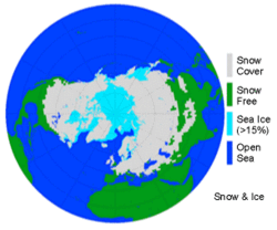 Northern Hemisphere snow extent map: Week of maximum snow extent (52.578 x 10⁶ km2) for the period 1979 to 1995 (image from 8-14 January 1979) Image courtesy of the National Snow and Ice Data Center, University of Colorado, Boulder. Source: Northern Hemisphere EASE-Grid Weekly Snow Cover and Sea Ice Extent product. (Source: NSIDC)
 We all associate snowstorms with cold weather, but snow's influence on the {C}weather and {C}climate continues long after the storm ends. Because snow is highly reflective, a vast amount of sunlight that hits the snow is reflected back into space instead of warming the planet. Without snow cover, the ground absorbs about four to six times more of the Sun's energy. The presence or absence of snow controls patterns of heating and cooling over Earth's land surface more than any other single land surface feature.
In many locations in recent decades, temperatures have risen while precipitation levels have remained largely the same. Satellite data have confirmed that average snow cover has decreased, especially in the spring and summer. Where snow cover is disappearing earlier in the spring, the large amounts of energy that would have melted the snow can now directly warm the soil.
Northern Hemisphere Snow Extent
What sensors on satellites are telling us about snow cover.
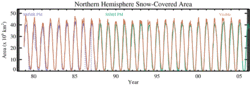 Northern Hemisphere monthly snow-covered area: This graph covers the years 1978-2005, based on NOAA snow charts (orange) and microwave satellite (purple/green) data sets. (Source: NSIDC)
 In terms of spatial extent, seasonal snow cover is the largest single component of the cryosphere and has a mean winter maximum areal extent of 47 million square kilometers, about 98 percent of which is located in the Northern Hemisphere.
Snow cover is an important climate change variable because of its influence on energy and moisture budgets. Snow cover accounts for the large differences between summer and winter land surface albedo, both annually and inter-annually. Snow may reflect as much as 80 to 90 percent of the incoming solar energy, whereas a snow-free surface such as soil or vegetation may reflect only 10 to 20 percent. A warming trend results in decreased snow cover. With the resulting decrease in reflected energy, absorption of solar radiation increases, adding heat to the system, thereby causing even more snow to melt. This is the classic positive temperature-albedo feedback mechanism, which is a key component in climate models. Surface temperature is highly dependent on the presence or absence of snow cover, and temperature trends have been linked to changes in snow cover.
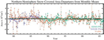 Northern Hemisphere snow-covered area anomalies: This shows Northern Hemisphere snow-covered area departures from monthly means, 1978-2005, from NOAA snow charts (orange) and microwave satellite (purple/green) data sets. The NOAA time series for this period exhibits a significant decreasing trend of -2.0 percent per decade (solid orange line); the microwave snow cover time series exhibits a decreasing trend of -0.7 percent per decade that is not significant at a 90 percent level (dashed green line). (Source: NSIDC)
 In addition to the albedo effect, snow cover represents a significant heat sink during the melt period of the seasonal cycle due to a relatively high latent heat of fusion. As a result, the seasonal snow cover provides a major source of thermal inertia within the total climate system, as it takes in and releases large amounts of energy with little or no fluctuation in temperature.
During the past four decades, satellite remote sensing has provided valuable information on hemispheric-scale snow extent. Since 1966, the National Oceanic and Atmospheric Administration (NOAA) has produced weekly snow extent maps for Northern Hemisphere land surfaces using visible-band satellite imagery. Because snow has such a high albedo compared to other surfaces on Earth, snow-covered areas appear much brighter in satellite imagery than most other surface types.
Remote sensing data sets from the microwave portion of the electromagnetic spectrum can also be used to derive snow cover maps. When snow covers the ground, some of the microwave energy emitted by the underlying soil is scattered by the snow grains; therefore, when moving from snow-free to snow-covered land surfaces, a sharp decrease in emissivity indicates the presence of dry snow.
These remote sensing data sets are derived using different types of analyses and separate regions of the electromagnetic spectrum, yet their results are strikingly similar. Both visible and passive microwave data sets show similar patterns of inter-annual variability, and both consistently indicate maximum snow extent that exceeds 40 million square kilometers for the Northern Hemisphere.
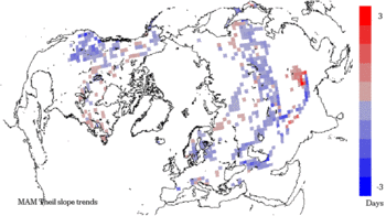 Spring duration of snow cover: This map shows trends derived from visible satellite data, 1978-2006. Image by Richard Armstrong and Mary Jo Brodzik, National Snow and Ice Data Center, University of Colorado, Boulder. (Source: NSIDC)
 The 28 year trend in snow extent derived from visible and passive microwave satellite data indicates an annual decrease of approximately one to three percent per decade with greater deceases of approximately three to five percent during spring and summer. Precipitation in regions of seasonal snow cover appears to be constant or increasing slightly in some locations over the same time period, which suggests that diminishing snow cover is the result of increasing temperatures. One region where the snow appears to be diminishing rapidly is the Western United States, especially in spring when the duration of snow cover has been decreasing by two to three days per decade (see blue-colored areas in the Spring Duration figure). This satllite-derived trend agrees with direct measurement of snow depth and extent on the ground.
 Public Domain Image
Further Reading
- Groisman, P., T.R. Karl, and R.W. Knight. 1994. Observed impact of snow cover on the heat balance and the rise of continental spring temperatures. Science 263: 198-200.
- Mote, P.W., A.F. Hamlet, M.P. Clark, and D.P. Lettenmaier. 2005. Declining Mountain Snowpack in Western North America. Bulletin of the American Meteorological Society 86: 39-49.
- NOAA Climate Prediction Center. Northern Hemisphere Snow Cover
- Robinson. D.A., and A. Frei. 2000. Seasonal variability of Northern Hemisphere snow extent using visible satellite data. Professional Geographer 52(2): 307-315.
| Disclaimer: This article contains information that was originally published by the National Snow and Ice Data Center. Topic editors and authors for the Encyclopedia of Earth may have edited its content or added new information. The use of information from the National Snow and Ice Data Center should not be construed as support for or endorsement by that organization for any new information added by EoE personnel, or for any editing of the original content. |