Water profile of China

Partially frozen marshes along the Songhua River floodplain. @ C.Michael Hogan
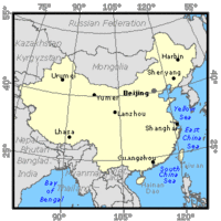 Map of China. (Source: FAO-Forestry)
 The water profile of China is dominated by increasing water shortages, espcially in North China. [Overdrafting] of groundwater on the North China Plain has particularly exacerbated the groundwater shortages of that region, and in the south of China overdevelopment of rice farming has placed large demands on water of that region.
China (35°00' North, 105°00' East) is located in the southeast of the Eurasian landmass, bounded by the Pacific Ocean in the southeast. The average altitude in China ranges from over 4,000 meters (m) in the west to less than 100 m in the east. The total area of China is about 9,598,030 square kilometers (km2) and consists of mountains (33 percent), plateaus (26 percent), basins (19 percent), plains (12 percent) and hills (10 percent). For administrative purposes, China is divided into 23 provinces, 3 municipalities and 5 autonomous regions, in addition to the special administrative region of Hong Kong.
There are about 129.4 million hectares (ha) of cultivable land, which is 13.5 percent of the total area. In 1995, the cultivated area was 95,851,000 ha, of which 3,767,000 ha were under permanent crops. In addition, there were about 400 million ha of prairie and 262.89 million ha of forested land. In 1996, the total sown area was 152,381,000 ha, of which grain crops (mainly rice, wheat and corn) represented 74 percent.
The population was 1,238,274,000 inhabitants in 1996, of which 68.5 percent lived in rural villages. The annual population growth declined from 1.66 percent in 1987 to 1.04 percent in 1996. The average population density is 129 inhabitants/km2, varying from less than 10 inhabitants/km2 in the west to 670 inhabitants/km2 in the east, and 2,042 inhabitants/km2 in Shanghai. The share of agriculture in gross national product (GNP) declined from 28.4 percent in 1978 to 21.2 percent in 1993. In 1996, the agriculture sector employed 71 percent of the economically active population, and it contributed about 20 percent of gross domestic product (GDP) in 1997.
Contents
Climate and water resources
Climate
Vast areas of east China and most of south China are affected by the east Asia monsoon climate. Mountains and plateaus prevent the monsoon from penetrating deeply into the northwest of the continent. The result is low precipitation. In winter, the mainland is generally under the influence of dry cold air masses from Siberia.
The mean annual precipitation is 648 millimeters (mm). In the coastal areas of the southeast and in some regions of the southwest, the mean annual precipitation exceeds 2,000 mm. It exceeds 1,000 mm to the south of the middle and lower reaches of the Yangtze River; is between 400 and 800 mm in the Huaihe River basin, in the northern plains, northeast and central China, is less than 400 mm in parts of northeast China and most of the hinterland in the northwest; and is less than 25 mm in the Tarim and the Qaidam basins. Precipitations are more significant in the summer months (from April/May to July/August in the south, and from June to September in the north).
Water resources
Rivers
 Table 1: Main rivers in China. (Source: FAO-Forestry)
 The average annual river runoff generated over the country is 2,711.5 cubic kilometers (km3), corresponding to a depth of 284 mm. Precipitation makes up 98 percent of total river runoff, the remaining 2 percent coming from melting glaciers.
In total, there are more than 50,000 rivers with a basin area of over 100 km2, 1,500 of them with a basin exceeding 1,000 km2. Rivers can be classified in two categories: those discharging into seas (outflowing rivers), and the inland rivers which run to depressions in the interior. Table 1 lists the length, drainage area and average discharge of the major rivers in China.
The total drainage area of the outflowing rivers covers 65.2 percent of the country's territory, of which 58.2 percent drain into the Pacific Ocean, 6.4 percent to the Indian Ocean and 0.5 percent to the Arctic Ocean; while that of that inland rivers covers 34.8 percent of the country's total area. The mean annual volume of water flowing into the sea is 1,724.3 km3.
 Table 2: Rivers flowing out of the country. (Source: FAO-Forestry)
 The volume of water flowing out of the country is estimated at 719 km3/year. This represents 26 percent of the total natural river runoff of the country (including the inflow from other countries).
The lower reaches of some rivers enter neighboring countries: to the north, the Heilongjiang River (Amur River) enters the Russian Federation before it empties into the Sea of Okhotsk (Sea of Okhotsk large marine ecosystem); the Ertix River joins the Ob River in Kazakhstan; the Ili River discharges into Lake Balkhash in Kazakhstan; the Suifen River flows through the Russian Federation to the sea at Vladivostok; to the southwest, the Yuanjiang, Lixianjiang, Panlongjiang rivers are the upper reaches of the Red River in Viet Nam; the Lancangjiang River becomes the Mekong River after it enters Lao PDR; the Nujiang River becomes the Salween River after it enters Myanmar; the Yalung Zangbo River is called the Brahmaputra River after it enters India; the Langqen Zangbo and Sengge Zangbo rivers of west Tibet and the Qipuqiapu River of Xinjiang are the upper reaches of the Indus River flowing through India and Pakistan into the Indian Ocean. The mean annual runoff of these rivers is given in Table 2.
Border rivers
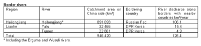 Table 3: Border rivers in China. (Source: FAO-Forestry)
 The main course of the Heilongjiang River (Amur) and its upstream tributaries (the Ergun and Wusuli rivers) flow along the border between China and the Russian Federation. After it receives the flow of the Songhua River (10.9 km3/year), the Amur River flows into the Russian Federation. The total flow of the Amur and Songhua rivers (117 km3/year) is considered as flowing out of China. The Tumen and Yalu rivers flow along the boundary between China and DPR Korea. However, the corresponding flow is not considered as outflowing as these rivers do not leave Chinese territory. Table 3 lists the catchment areas and mean discharges of the border rivers.
Volume of water entering the country
 Table 4: Rivers entering China from neighboring countries. (Source: FAO-Forestry)
 There are 12 main rivers that enter China from six neighboring countries (Mongolia, Pakistan, India, Kazakhstan, the Kyrgyz Republic and Viet Nam). The mean annual volume of water entering the country is 17.2 km3, of which 4.2 percent in the Heilongjiang basin, 52.9 percent in inland rivers, 0.7 percent in rivers in the southwest, and 42.2 percent in the Pearl River basin. Table 4 presents data on rivers entering China.
Glaciers
The total area of glaciers in China is about 58,651 km2 extending over six northwestern and southwestern provinces or autonomous regions (Gansu, Qingha, Xinjiang, Tibet, Sichuan and Yunnan). The country's glacier storage is around 5,100 km3 in total. The amount of mean annual glacier meltwater is about 56 km3.
Groundwater Resources
The average annual groundwater resources for the whole country are estimated at 828.8 km3. That part which reaches the rivers as base flow or comes from river seepage is estimated at 727.85 km3.
Total renewable water resources
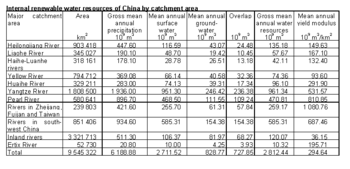 Table 5: Internal renewable water resources in China. (Source: FAO-Forestry)
 The internal renewable water resources (IRWR) of China are summarized in Table 5. The total renewable water resources are computed by adding the total external inflow (17.169 km3/year) to the IRWR, i.e., 2,829.6 km3/year.
Lakes and dams
There are about 2,300 lakes (excluding seasonal ones) in China with a total storage of 708.8 km3, of which the freshwater portion is 31.9 percent (226.1 km3). There are five major lake districts as listed in the Table 6.
 Table 6: Lakes in China. (Source: FAO-Forestry)
 At the end of 1995, the number of artificial reservoirs was 84,775 with a total capacity of 480 km3. Of these, 387 are classed as large reservoirs with a total capacity of 349 km3; 2,593 are medium reservoirs with a total capacity of 72 km3; and 81,795 are small reservoirs with a total capacity of 59 km3.
China has a gross theoretical hydropower potential of 5,932 terawatt-hours per year (TWh/year) (779 gigawatts [GW]) and a technically feasible potential of 1,925 TWh/year (383 GW). The economically feasible potential evaluated in 1993 was 1,261 TWh/year (292 GW). Of the 220 GW total power plant capacity at the end of 1995, hydroelectric plants accounted for 53,868 megawatts (MW), while the generation from hydroplants in 1994/95 was 167.2 TWh.
Water withdrawal
 Figure 1: Water withdrawal in China. (Source: FAO-Forestry)
 The total water withdrawal was 525.5 km3 in 1993, of which 385 km3 was used for irrigation, 22.66 km3 for rural domestic uses and livestock, 25.17 km3 for urban domestic and public uses, and 92.55 km3 for industrial water use (Figure 1).
The total water demand for 2000 is estimated at 593 km3, with 7 percent for domestic and municipal use, 21 percent for industry, and 72 percent for irrigation.
In 1995, the total amount of wastewater produced was 37.29 km3, of which 23.33 km3 was treated. The re-used treated volume was 13.39 km3.
Irrigation and drainage development
 Figure 2: Growth of irrigation in farmland areas since 1975. (Source: FAO-Forestry)
 Irrigation and drainage in China have a long history. The first canals dug to divert water and wells drilled to lift water for irrigation agriculture were constructed four thousand years ago.
Since the founding of the People's Republic of China in 1949, irrigation and drainage have experienced a period of vigorous development. From 1958 to 1985, about 64,368 million yuan were spent on irrigation and drainage projects. The irrigated area for farmland increased from 16 million ha in 1949 to 51 million ha in 1996 (Figure 2).
After 1949, in order to promote agricultural production, pump irrigation and drainage were developed rapidly. In north China, insufficient surface water resources have meant that since 1950 the government has had to rely on groundwater for the development of irrigation projects in the Hebei, Henan and Shandong provinces. In 1985, the area irrigated through tube wells in the country was 11.13 million ha. In 1989, the pump irrigated area reached 26.87 million ha.
Sprinkler irrigation was introduced in China in the early 1950s. The first sprinkler irrigation project was constructed in Shanghai in 1954. Sprinkler irrigation and localized irrigation were considerably developed in the late 1970s. In 1976, the area of sprinkler irrigation was about 67,000 ha. It increased until 1980, but large areas were then abandoned due to the poor quality of equipment and poor management. In 1989, 106,530 ha of farmland had developed water conservation techniques for irrigation, of which 95,140 ha were for sprinkler irrigation, 7,370 ha for trickle irrigation and 4,020 ha for mist irrigation (trickle and mist are two types of localized irrigation).
 Figure 3: Origins of irrigation water. (Source: FAO-Forestry)
 The irrigated farmland area (area regularly plowed for growing agricultural crops) in China was about 48 million ha in 1990, of which 21.3 million ha for paddy field, 17.3 million ha for grain, and 9.3 million ha for cash crops and vegetables. In 1994, land under irrigation in mainland China (excluding Hong Kong) covered 53,221 440 ha, of which 49,938,070 ha of irrigated farmland, 1,209,000 ha of orchards, 864,050 ha of forests, 770,600 ha of pastures and 439,720 ha of other irrigated land. The irrigated areas are classed by water source as follows: from reservoirs and ponds, 31 percent; through water diversion, 28 percent; pump lifting irrigation, 19 percent; from tube-wells, 18 percent; other, 4 percent (Figure 3).
The territory of China can be divided into three irrigation zones:
- The zone of perennial irrigation, where precipitation is less than 400 mm and irrigation is necessary for agriculture. It covers mainly the northwest regions and part of the middle reaches of the Huanghe River.
- The zone where precipitation ranges from 400 to 1,000 mm, strongly influenced by the monsoon, with a consequently uneven precipitation distribution. Irrigation here is necessary to secure production. This zone includes the Hangh Huai Hai plain and northeast China.
- The zone of supplementary irrigation, where annual precipitation exceeds 1,000 mm. Irrigation is still necessary for paddy (especially to improve cropping intensity), and supplementary irrigation is sometimes required for upland crops. This zone covers the middle and lower reaches of the Changjiang River, the Zhujiang and Minjiang rivers and part of southwest China.
 Figure 4: Types of irrigation schemes in China. (Source: FAO-Forestry)
 In terms of scheme size, the irrigation areas of China are divided into three categories. Large irrigation districts cover areas over 20,000 ha; medium districts cover areas between 667 and 20,000 ha; and small districts are under 667 ha. The large and medium irrigation districts are generally administrated by special governmental organizations. The small ones are usually farmer managed. Some small ponds, wells and pumping stations are owned by individuals. There are 173 large-scale irrigation districts (8.76 million ha) and 5,389 medium-scale irrigation districts (13.74 million ha) (Figure 4).
The Ministry of Water Resources estimates the maximum possible area which might be brought under irrigation in the first half of the next century at 64 million ha. Nevertheless, as much of the land proposed for irrigation is located in arid and semi-arid zones, a long-term viable strategy has to be formulated as to how to provide additional water resources to irrigate these lands. The total area equipped for irrigation, including farmland, orchards and pastures, was 52,943,200 ha in 1996 (Figure 5 shows the distribution of irrigated crops for 1994). The irrigated area represents 55 percent of the total cultivated area. The area actually irrigated in 1995 was 48.2 million ha, of which tube-well irrigation represented 12.79 million ha.
 Figure 5: Area under irrigation. (Source: FAO-Forestry)
 Until 1995, the total installed capacity of water lifting machines for irrigation and drainage was 68,240 MW. The pumping irrigation and drainage area amounted to 33.27 million ha, of which the pumping irrigation area was 29.07 million ha.
Surface irrigation is the method practiced (mainly for rice, wheat, millet, vegetables, corn and cotton) on about 99 percent of the total equipped irrigated area. The remaining 1 percent is under sprinkler and localized irrigation. Since the 1970s, sprinkler irrigation and micro-irrigation (mainly for fruit trees, vegetables and tea) have been introduced.
In 1993, the total sown area was 147.74 million ha and the total grain production was 456.5 million tons (t). The main grain crops are rice, wheat and corn, which make up 84 percent of total grain production. About two-thirds of grain production comes from irrigation. According to a nationwide survey in the early 1980s, the average paddy rice yield of irrigated farmland was 7.3 t/ha and the average yield of non-irrigated paddy rice was 2.1 t/ha. In 1995, the International Rice Commission estimated an average yield of 6 t/ha for irrigated paddy rice.
In 1996, the area subject to waterlogging was 24.58 million ha, of which 20.28 million ha were controlled through drainage. In 1995, the power drained area was 4.2 million ha. Saline-alkaline cultivated areas cover 7.73 million ha, of which 5.51 million ha have been improved or reclaimed. The total cultivated area protected from floods is 32.69 million ha. In northern China in particular, waterlogging, salinization and alkalization have been the main constraints on agricultural production. In this region, there are about 6.70 million ha of low-yielding farmland prone to waterlogging (out of a total of 18.09 million ha of farmland), and 33,500 ha of saline-alkaline soils.
Under government regulations, all water users must pay water charges. Since 1985, the water charge has, in principle, been calculated on the basis of the cost of the water supply. The water charge for agriculture is usually lower than that for industry. It is calculated either according to the quantity of water supplied, the beneficial area, or a mixture of basic water charge plus a metered water charge. Where shortages occur, a rational water allocation system is practiced and dissuasive charges are applied to extra volumes of water. On average, water charges for irrigation varied between 150 and 300 yuan/ha (US$17.96 and 35.92/ha) in 1995. The average cost for sprinkler irrigation development was 6,000 yuan/ha (US$720/ha), and that for micro-irrigation was 18,000 yuan/ha (US$2,200/ha) in 1995.
Institutional environment
China has made some major mistakes in national management of its water resources through its strong central planning environment. Chief among these errors are: (a) systematic overdrafting of groundwater on the North China Plain for pursuit of short term crop yields; (b) overreliance on rice farming in the south of China; and (c) construction of the Three Gorges Dam which has altered the habitat of the central Yangtze River through siltation and the Yangtze Estuary through inadequate sediment depostion. The main institutions involved in water resources management are:
- the Ministry of Water Resources (MWR), responsible for water resources survey and assessment, rural water planning and development, and management and protection of water resources. The Ministry of Water Resources directly supervises the Water Resources and Hydroelectric Power Construction Corporation, and administers 13 higher education institutions and 7 regional basin commissions;
- the Local Water Resources Management Department, responsible for water administration at provincial level. Each province has a Water Resource Bureau responsible for planning, survey, design, construction, operation and management of irrigation, drainage, flood control works, and rural hydro-electricity. Water resources bureaux at the prefecture and county levels are directly responsible for the construction and maintenance of main and secondary canals, associated irrigation and flood control structures, and medium-sized reservoirs. Townships and villages share responsibility for constructing and maintaining branch canals, ancillary works, and small reservoirs;
- the Ministry of Geology and Mineral Resources cooperates with the MWR in the management of groundwater resources;
- the State Environmental Protection Bureau deals with the protection of water resources;
- the Ministry of Agriculture is responsible for state farm water conservation, construction and management;
- the Ministry of Construction is responsible for urban water conservancy including groundwater exploitation and protection.
China's water law was enacted in 1988 and establishes principles, general guidelines, and technical standards for water resources management.
In China, small-scale irrigation and drainage works are built and managed by the farmers themselves. The on-farm engineering facilities below the level of tertiary canals in large-scale irrigation districts are also built and managed by farmers themselves. The 'representative conference of irrigation districts' is a form of Water User Association (WUA), allowing for farmers' participation in the management of the irrigation schemes.
Trends in water resources management
The further development of irrigation in China faces a number of problems:
- The whole country is facing increasing water shortages, especially in north China.
- Most irrigation projects constructed in the 1950s and 1960s can no longer be operated effectively. This results in a continuous decline in irrigation benefits and has a direct impact on the stability of agricultural development and on the economy.
- The policy of low water fees and free water delivery services practiced in irrigation and drainage projects in the past has led to a situation where the funds needed for their regular maintenance and rehabilitation have not been available.
In order to achieve the goals stipulated by the government in the 9th Five Year Plan, irrigation should increase by 3.3 million ha and grain production capacity should increase by 40-50 million t in the period 1995-2000. To achieve these objectives, the government has decided to allocate part of the basic national construction fund for agriculture to the rehabilitation of the irrigation works. The main projects will rehabilitate the key structures in the irrigation districts, control canal seepage, and erect new management facilities. The costs of the rehabilitation and modernization of irrigation projects will be borne by the central, provincial, prefecture and county governments.
In 1985, the government issued a new rule requiring water charges to be collected according to the cost of water delivery. At present, water charges are on average between a half to two-thirds of the water delivery costs. It is expected that cost recovery will be accelerated in the near future, with regional variations to take account of farmers' ability to pay.
Water User Associations (WUAs) are recommended by international organizations such as the World Bank. Pilot projects in Hunan and Hubei provinces are currently testing the capacity of WUAs to manage and administer irrigation schemes autonomously. If successful, these approaches may be extended to the rest of the country.
Further Reading
- Water profile of China, Food and Agriculture Organization.
- The World Factbook: China, Central Intelligence Agency.
- US - China Water Resource Management Program, Los Alamos National Laboratory.
- The World's Water: Information on the World's Freshwater, the Pacific Institute for Studies in Development, Environment, and Security.
- Chinese Hydraulic Engineering Society and Chinese National Committee on Irrigation and Drainage. 1991. A concise history of irrigation in China, p. 102-182.
- Department of Hydrology, Ministry of Water Resources, PRC. 1992. Water resources assessment for China, p. 246. China water and power press. ISBN: 7120015818.
| Disclaimer: This article is taken wholly from, or contains information that was originally published by, the Food and Agriculture Organization. Topic editors and authors for the Encyclopedia of Earth may have edited its content or added new information. The use of information from the Food and Agriculture Organization should not be construed as support for or endorsement by that organization for any new information added by EoE personnel, or for any editing of the original content. |