Changjiang Plain evergreen forests
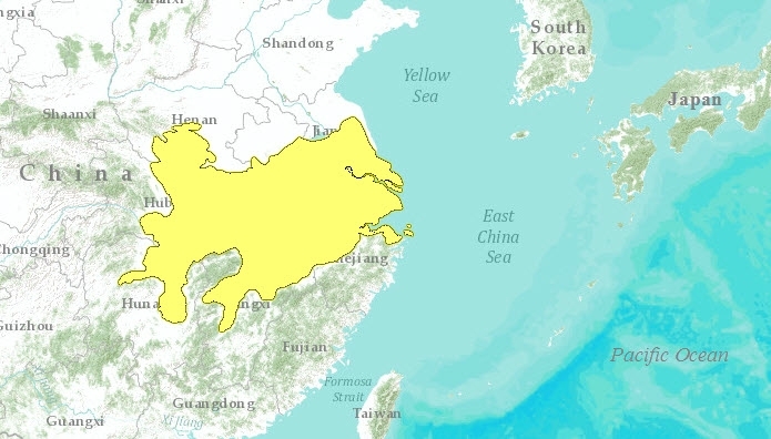
The Changjiang (Yangtze) River emerges from the Three Gorges to flow across 1000 kilometers (km) of low lying alluvial plain in a series of "nine intestine-like bends." Here the Chiangjiang Basin supports vegetation of subtropical to temperate oak forest on well-drained alluvial deposits and low hills. Low-lying areas consist of shallow lake basins. These are seasonally inundated and surrounded by extensive wetlands that have historically provided important winter habitat for great numbers of migratory birds, as well as aquatic animals like the baiji or Yangtze River dolphin and the Yangtze alligator. A few of these areas are still relatively intact, but most were converted to paddy rice agriculture and fish aquaculture centuries ago. Due to the fertility of the land, and many thousands of years of human habitation, flat areas away from the lakes have been converted to agriculture, although some of the wetland habitats and hill slopes support remnants of the original vegetation.
Location and General Description
This ecoregion is delineated to the south and west by the hills that enclose the lower Chiangjiang Plain, and to the north by a low watershed divide that marks the Huang He (Yellow River) Plain. Floodplains and low hills once supported extensive evergreen oak forests (Cyclobalanopsis spp., Castanopsis spp.) associated with laurels (Phoebe spp., Cinnamomum spp., Persea spp.) as well as some tropical forest taxa. Reed swamps surrounded seasonally inundated lake basins. Today, some of this habitat remains. Most, however, has been converted to paddy rice agriculture.
Hill areas such as the Dabie Shan once supported a climax forest of conifers (Pinus massoniana, Cunninghamia lanceolata) and deciduous broadleaf taxa like birch (Betula spp.) and maple (Acer spp.). Today most of these areas are reduced to shrublands.
Many areas have not supported their potential subtropical forest vegetation for thousands of years. At present, the wetland and aquatic habitats probably hold the greatest conservation significance. Large shallow lakes like Poyang and Dongting support many rare, endemic aquatic vertebrates and great numbers of waterfowl species, some of which are highly endangered.
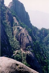
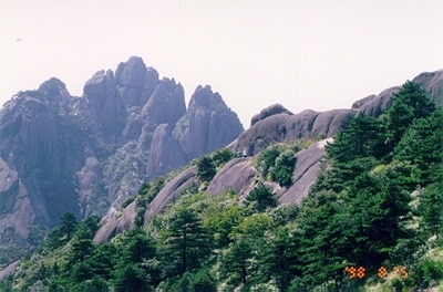
 Huang Shan mountains, Anhui Province, China. (Photograph by Stephen Mann) The hydrology of Poyang Lake is distinctive. It changes size and and varies in depth by 11 meters (m) between the wet and dry seasons, filling with backflow from the Chiangjiang at the onset of the wet summer season and draining into the river during winter. Effects on this hydrological pattern due to the Three Gorges Dam, currently under construction on the Chiangjiang River, require careful study and possible mitigation.
Dongting Lake also varies seasonally in size and depth. Its area increases from 3,700 to more than 13,000 km2 and its depth by more than 10 meters during the summer. This area, surrounded by some of the most productive rice agriculture in China, has been affected by humans since prehistoric times.
==
==
==
Biodiversity Features
.jpg) Chinese water deer (Hydropotes inermis). (Photograph by Deer-UK.Com)
Chinese water deer (Hydropotes inermis). (Photograph by Deer-UK.Com) Mammals adapted to the seasonal ebb and flow of the Chiangjiang include the Chinese water deer (Hydropotes inermis) which swims to high ground during the onset of the flood season. Otter (Lutra lutra) also inhabit watercourses.
Birds of conservation interest include the Siberian crane (Grus leucogeranus), 3,000 of which overwinter at Poyang Lake, China’s largest. This overwintering group represents an estimated 98 percent of the world population for this species. Other rare and endangered waterfowl that visit Poyang Lake include Oriental white stork (Ciconia boyciana), swan goose (Anser cygnoides), and white-naped crane (Grus vipio). Large congregations of other migratory waterfall also raft on Poyang Lake during winter.
Other species of conservation interest include aquatic vertebrates like the Yangtze River dolphin (Lipotes vexillifer), of which fewer than 100 individuals (possible as few as 5) survive in the vicinity of Poyang Lake, sturgeons such as the Chinese sturgeon (Acipenser sinensis) and white sturgeon (Psephurus gladius), the Chinese alligator (Alligator sinensis), and giant salamander (Megalobatrachus davidiana).
Current Status
Forests have been mostly extirpated, replaced by rice paddies, conifer plantations or scrub vegetation. Much aquatic habitat has been converted to rice and fish farming and hundreds of miles of river have been contained between earthen banks. Conservation measures are in place at Poyang and some of the other large, shallow lakes, but enforcement is difficult.
Types and Severity of Threats
Many of the traditional threats to biodiversity that are seen throughout China–clearing dry land and reclaiming wetlands for agriculture–have been occurring for centuries. Hunting continues and water pollution is an ongoing problem.
One matter of ecological concern, however, is unprecedented. The Three Gorges Dam project, set to dam the Yangtze at the upper end of the Chiangjiang Plain, is the largest waterworks project in human history. Scheduled for completion in 2009, it is intended to reduce flood damage downstream and to generate clean electricity. There has been much concern about the ecological costs of this project. At the very least, it threatens to alter greatly the hydrological cycles fundamental to the ecology of lakes like Poyang and Dongting. Ecological consequences of the Three Gorges Dam project, and feasible mitigation strategies, need careful consideration.
Justification of Ecoregion Delineation
CVMCC Vegetation Map of China deciduous broadleaf forests, mixed with conifer, (classes 13a and 8a), are considered to be the original dominant land cover. However, very little is left due to agricultural use (72a, 73a). The ecoregion also includes warm-temperate mixed shrublands (class 32a). This region is comparable to the Dabeishan biogeographic subunit in the Oriental Deciduous Forests according to Mackinnon et al.
Additional information on this ecoregion
- For a shorter summary of this entry, see the WWF WildWorld profile of this ecoregion.
- To see the species that live in this ecoregion, including images and threat levels, see the WWF Wildfinder description of this ecoregion.
Further Reading
- Boqiang Qin. 1999. Hydrodynamics on Lake Taihu, China. Ambio 26(8)
- Chinese Vegetation Map Compilation Committee. 1979. Vegetation map of China. Map (1:10,000,000). Science Press, Beijing, China.
- MacDonald, D. editor. 1999. The Encyclopedia of Mammals. Barnes and Noble Books. ISBN: 0816064946
- MacKinnon, J. 1996. Wild China. The MIT Press, Cambridge MA. ISBN: 0262133296
- MacKinnon, J. and K. Phillipps. 2000. A Field Guide to the Birds of China. Oxford University Press, New York. ISBN: 0198549407
- Mackinnon, J., M. Sha, C. Cheung, G. Carey, Z. Xiang, and D. Melville. 1996. A biodiversity review of China. World Wide Fund for Nature, Hong Kong.
- Zhao, J. editor. Zheng Guangmei, Wang Huadong, Xu Jialin. 1990. The Natural History of China. McGraw Hill Publishing Company, New York. ISBN: 0002190435
| Disclaimer: This article contains information that was originally published by the World Wildlife Fund. Topic editors and authors for the Encyclopedia of Earth have edited its content and added new information. The use of information from the World Wildlife Fund should not be construed as support for or endorsement by that organization for any new information added by EoE personnel, or for any editing of the original content. |

