Central Eastern Rainforest Reserves, Australia
Contents
- 1 Geographical Location
- 2 Date and History of Establishment
- 3 Area
- 4 Land Tenure
- 5 Altitude
- 6 Physical Features
- 7 Climate
- 8 Vegetation
- 9 Fauna
- 10 Cultural Heritage
- 11 Local Human Population
- 12 Visitors and Visitor Facilities
- 13 Scientific Research and Facilities
- 14 Conservation Value
- 15 Conservation Management
- 16 IUCN Management Category
- 17 Further Reading
Geographical Location
The Central Eastern Rainforest Reserves (31°55'-32°14'S, 151°17'-151°42'E) comprise a World Heritage Site.
- Main Range. The reserves are contiguous, apart from one state forest, and lie in a north-south band along the Main Range. This extends from the northern end of the Mistake Mountains to the border between New South Wales and Queensland. Two reserves are in New South Wales.
- Focal Peak Group. On the New South Wales/Queensland border and extending down the Richmond Range, between the Main Range and Shield Volcano Group.
- Shield Volcano Group. The sites, many of which are contiguous, lie on the border between New South Wales and Queensland along the McPherson and Tweed Ranges. Mount Warning and Mount Chinghee are isolated mountain peaks. This group also includes the Nightcap Range in New South Wales, south of Mount Warning.
- Iluka Nature Reserve. At the coast, due east of the Washpool and Gibraltar Range, on a peninsula, the southern end of which forms the northern bank of the mouth of the Clarence River.
- Washpool and Gibraltar Range. Gibraltar Range and Washpool National Parks are contiguous and form a block of mountainous country at the eastern edge of the New England tablelands. They are bounded by the Timbarra (Rocky), Mann and Clarence rivers. The boundary follows the Demon Fault, marked by the Timbarra River, on the west and it approximates to the escarpment on the east.
- New England Group. New England and Dorrigo National Parks and Cunnawarra Flora Reserve, which include sections of the Great Escarpment and coastal lowlands, form a rugged amphitheater to the headwaters of the Bellinger and Macleay Rivers and theirtributaries. Mount Hyland Nature Reserve, lies some 35 kilometers (km) north-west of Dorrigo township and comprises the southernmost of a series of minor peaks extending north to Chaelundi Mountain.
- Hastings-Macleay Group. This group lies in the rugged hinterland west of Kempsey and Port Macquarie. It includes most of the heavily dissected gorge country of the upper Macleay, an extension of the New England Tablelands, the headwaters of the Hastings and Forbes Rivers, Mount Banda Banda and part of the Carrai Plateau.
- Barrington Tops Area. This group includes part of a plateau extension of the Liverpool Range and extends down its south-eastern, southern and south-western slopes.
Date and History of Establishment
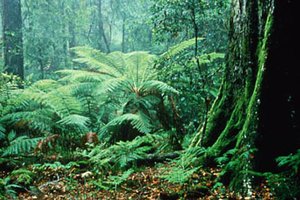 The rain forest floor within the Australian Central Eastern Rainforest Reserves. (Source: Australian Government: Department of the Environment and Heritage)
 - 1 - Main Range
- 1986 Acacia Plateau Flora Reserve
- 1965 Main Range National Park
- 1967 Mount Mistake National Park
- 1986 Wilsons Peak Flora Reserve
- ???? State Forests
- 2 - Focal Peak Group
- 1983 Bungdoozle Flora Reserve
- 1983 Cambridge Plateau Flora Reserve
- 1986 Captains Creek Flora Reserve
- 1984 Mallanganee Flora Reserve
- 1947 Mount Barney National Park
- 1986 Mount Clunie Flora Reserve
- 1973 Mount Nothofagus Flora Reserve
- 1995 Tooloom National Park
- 1937 Tooloom Scrub Flora Reserve
- 1995 Toonumber National Park
- ???? State Forests
Tooloom and Toonumber National Parks, which were proclaimed in 1995, include areas previously reserved as flora reserves. Tooloom National Park comprises most of Tooloom Scrub Flora Reserve, originally gazetted in 1937, as well as former state forest. Toonumber National Park includes all of the former Murray Scrub Flora Reserve (created in 1983) and Dome Mountain Flora Reserve (created in 1987). These flora reserves formed part of the 1994 World Heritage listing of the Central Eastern Rainforest Reserves.
- 3 - Shield Volcano Group
- 1987 Amaroo Flora Reserve
- 1979 Border Ranges National Park
- 1915 Lamington National Park
- 1963 Limpinwood Nature Reserve
- 1988 Mebbin Lagoons Flora Reserve
- 1992 Mount Chinghee National Park
- 1966 Mount Warning National Park
- 1983 Nightcap National Park
- 1981 Numinbah Nature Reserve
- 1990 Springbrook National Park
Border Ranges National Park was first proclaimed by government gazette in 1979. Its size was greatly increased by the addition of Wiangarie, Roseberry and part of Mount Lindesay State Forests under the Forestry Revocation and National Parks Reservation Act, 1983. Nightcap National Park was created from Goonimbar and part of Whian Whian State Forests under the same act.
- 4 - Iluka Nature Reserve
Specifically reserved for conservation purposes on 9 July 1976 under the National Parks and Wildlife Act, 1974 (New South Wales).
- 5 - Washpool and Gibraltar Range
- 1963 Gibraltar Range National Park
- 1983 Washpool National Park
With the opening of the Gwydir Highway in December 1960, the Gibraltar Range became accessible and moves were initiated to establish a national park. Approximately 14,000 hectares (ha) was reserved for public recreation by notification in the Government Gazette of 8 March 1963 and further 1,425ha was added by notification in the Government Gazette of 17 September 1965. The area was formally created a national park under the National Parks and Wildlife Act, 1967. Further land was incorporated with the park in 1970 and 1977. Washpool National Park was reserved under the Forestry Revocation and National Parks Reservation Acts of 1983 and 1984.
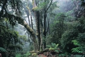 New England National Park, in Central Eastern Australia. (Source: Department of Environment & Climate Change NSW)
 - 6 - New England Group
- 1927 Dorrigo National Park
- 1989 Gunnawarra Flora Reserve
- 1984 Mount Hyland Nature Reserve
- 1935 New England National Park
Both parks were initially reserved under the Crown Lands Act and were included under the National Parks and Wildlife Act in 1967. They have subsequently been enlarged on numerous occasions from 1968 to 1989, and by the Forestry Revocation and National Parks Reservation Acts of 1983 and 1984. Mount Hyland Nature Reserve, formerly state forest, was established under the 1984 Act.
- 7 - Hastings-Macleay Group
- 1984 Banda Banda Flora Reserve
- 1988 The Castles Flora Reserve
- 1985 Fenwicks Scrub Flora Reserve
- 1974 Mount Seaview Nature Reserve
- 1986 Oxley Wild Rivers National Park
- 1975 Werrikimbe National Park
Werrikimbe National Park was first reserved by proclamation in the Government Gazette of 11 July 1975, with extensions by Government Gazette of 24 December 1976, 21 October 1977 and 12 June 1987. A further area was added under the Forestry Revocation and National Parks Reservation Act 1984. Mount Seaview was originally designated as Faunal Reserve No. 36 in the Government Gazette of 5 February 1965. This, and an additional area were established as a nature reserve under the National Parks and Wildlife Act 1974. A further extension was made under the Forestry Revocation and National Parks Reservation Act 1984. Banda Banda and Fenwicks Scrub Flora Reserves were established by proclamations of Government Gazettes of 1984, 1985 and 1989 as part of previously established forest reserves.
Oxley Wild Rivers National Park was created in 1986 from the then Apsley Gorge and Yamowitch Gorge National Parks which had been created in 1976 and 1980, respectively. In 1988, The Hole creek Nature Reserve (originally created in 1965 with additions in 1980) and Rowley's Creek Gulf Nature Reserve (created 1962) were added to the park. The park has almost doubled in size since 1988 with additions in 1989, 1990, 1992, 1993 and 1995.
- 8 - Barrington Tops Area
- 1967 Barrington Tops National Park
- 1966 Kerripit Beech Flora Reserve
- 1986 Jerusalem Creek Flora Reserve
Barrington Tops National Park was gazetted in 1967 under the National Parks and Wildlife Act 1967, with further additions made by Governmental Gazette in 1970, 1972, 1974, 1981, 1984 and 1987, and land reserved under the Forestry Revocation and National Parks Reservation Act 1984.
Most of the New South Wales national parks and nature reserves listed above, and Banda Banda and Mount Nothofagus Flora Reserves were originally inscribed on the WorldWorld Heritage List in 1986 as the Australian East Coast Temperate and Subtropical Rainforest Parks. All sites in Queensland and the following sites in New South Wales were added in the 1994 listing.
Toonumber National Park, Tooloom National Park, Oxley Wild Rivers National Park, Wilsons Peak Flora Reserve, Mount Clunie Flora Reserve, Amaroo Flora Reserve, Mebbin Lagoons Flora Reserve, Acacia Plateau Flora Reserve, Captains Creek Flora Reserve, Tooloom Scrub Flora Reserve, Bungdoozle Flora Reserve, Cambridge Plateau Flora Reserve, Mallanganee Flora Reserve, Cunnawarra Flora Reserve, The Castles Flora Reserve, Fenwicks Scrub Flora Reserve, Kerripit Beech Flora Reserve, Jerusalem Creek Flora Reserve.
Area
approximately 370,000ha (New South Wales: approx. 310,000 ha; Queensland: approximately 60,000 ha)
- Main Range GroupMain Range National Park 17,794, Goomburra State Forest 2,067#, Spicers Gap State Forest 257#, Gilbert State Forest 84#, Emu Vale State Forest 268#, Gambubal State Forest 2,260#, Teviot State Forest 390#, Acacia Plateau Flora Reserve 585, Wilsons Peak Flora Reserve 184.
- Focal Peak GroupMount Barney National Park 10,831#, Burnett Creek State Forest 1,076#, Toonumber National Park 1,080#, Tooloom National Park 1,640#, Mount Clunie Flora Reserve 485, Mount Nothofagus Flora Reserve 650, Captains Creek Flora Reserve 380, Tooloom Scrub Flora Reserve 25, Bungdoozle Flora Reserve 145, Cambridge Plateau Flora Reserve 870, Mallanganee Flora Reserve 222.
- Shield Volcano GroupSpringbrook National Park 2,480#, Lamington National Park 20,469, Mount Chinghee National Park 1,257, Border Ranges National Park 31,508, Nightcap National Park 4,945, Mt Warning National Park 2,380, Limpinwood Nature Reserve 2,646, Numinbah Nature Reserve 858, Amaroo Flora Reserve 36, Mebbin Lagoons Flora Reserve 11
- Iluka Nature ReserveIluka Nature Reserve 136
- Washpool and Gibraltar RangeWashpool National Park 27,715, Gibraltar Range National Park 17,273
- New England GroupNew England National Park 29,985, Dorrigo National Park 7,885, Mount Hyland Nature Reserve 1,636, Cunnawarra Flora Reserve 400
- Hastings-Macleay GroupOxley Wild Rivers National Park 93,220, Werrikimbe National Park 35,178, Mount Seaview Nature Reserve 1,703, The Castles Flora Reserve 2,360, Banda Banda Flora Reserve 1,610, Fenwicks Scrub Flora Reserve 110
- Barrington Tops GroupBarrington Tops National Park 39,120, Kerripit Beech Flora Reserve 243, Jerusalem Creek Flora Reserve 60
NB: Area where not specified is in ha.
- Not all of each reserve lies within the nominated Central Eastern Rainforests of Australia World Heritage Site. The figure given represents only the area of each reserve included. Maps of reserves which are only partly included in the nomination, form Appendix 6 of the World Heritage nomination.
In addition, five Rabbit Board paddock reserves (144 ha), two lots of prisons purposes land (46 ha) and various road reserves are included in the Queensland portion of the territory. Part of Goomburra State Forest and all the other state forests are due to be gazetted as National Park in the near future.
Land Tenure
Governments of Queensland and New South Wales.
Altitude
The sites cover a range of altitudes from sea level to almost 1,600 meters (m). Due to their location on the Great Escarpment, a dramatic change in altitude is found within many sites.
Physical Features
- Main RangeThe eastern edge of the Main range is a steep escarpment, part of the Great Escarpment, with peaks up to 1,100 m above the broad valley to the east. The upper part of the scarp consists of cliffs of Basalt]]ic rocks. Lower down, talus slopes, in many places, obscure the lower members of the volcanic sequence and the contact with the underlying Mesozoic sedimentary rocks.The Great Divide is close to, or coincides with, the top of the escarpment. West of the Divide the original Basaltic tableland has been strongly dissected by streams, leaving only ridges and a few small remnants between them. The volcanic rocks, dominantly Basalts, have a total thickness of up to 900 m beneath the highest points on the Divide; they have been divided into two formations of almost equal thickness. The lower formation, the Governors Chair Volcanics, contains well-marked members interbedded with the Basalts. The upper formation consists entirely of Basaltic rocks and is widespread over an area of 160,000 ha. The trachytes of the lower formation exhibit outstanding cliff faces at The Steamers, in Emu Creek and at Mount Castle on the escarpment.The Main Range, although on the whole drier than the McPherson Range, has at least three major waterfalls. The Main Range volcanics are of late Oligocene to early Miocene age.
- Focal Peak GroupThe Mount Barney Intrusive Complex consists of a variety of igneous rocks, mainly intrusive, forming a mountainous region. Several centers of intrusion have been recognized along an east-west line, including Focal Peak and Mount Gillies, centers for eruption of basalt and rhyolite of the Focal Peak shield volcano. Mount Barney itself is a mountain mass composed of granophyre, about 24 million years old. Volcanic influence is evident along the Richmond Range in the form of isolated basalt caps.
- Shield Volcano GroupThe Border Ranges, where the majority of the sites are located, lie along the New South Wales-Queensland border, and include a large area to the north and south. They are formed from predominantly Ibasaltic Tertiary volcanic rocks that were deposited in numerous sub-horizontal layers. The Border Range sites are remnants of the easily recognizable Tweed Shield Volcano, which, despite its age (20.5-23.5 million years), is probably one of the best preserved for its age in the world. The western part of Border Ranges lie within the area of Focal Peak Volcano. The erosion caldera of the Tweed Shield Volcano, one of the largest in the world, is remarkable for its size, prominent central mountain mass (Mount Warning) and because the caldera floor has been eroded down to basement rock by Tweed River.Mount Warning itself represents the original neck of the volcano which, being more resistant (comprising syenite, gabbro and monzonite) than the surrounding basalt and rhyolite, remains as an isolated plug. Differential erosion of the basalt and rhyolitic lava flows is responsible for a landscape characterized by sloping valleys below vertical rhyolite cliffs and such features as the tiered shape of Mount Lindesay. Basalts give rise to krasnozems on the plateau and less acidic prairie soils on the slopes, both of which are moderately fertile. Weathering of rhyolites produces yellow podzolic soils of much lower fertility.The intrusive rocks of the Mount Warning mountain mass are isolated from the remaining parts of the volcanic shield by a broad, deep valley, eroded below the level of the lowest basalts to expose the basement of Palaeozoic and Mesozoic rocks. Basalts and rhyolites of the shield have been cut back uniformly to produce precipitous cliffs in an arc around the central mass. This formation, the Mount Warning erosion caldera, is one of the major examples of this landform in the world. The original upper surface of the volcano has been dissected by radially arranged streams, leaving intervening ridges and sloping plateau remnants. A range of rock types occur, from extensive flows from the main vents and from the more local activity of numerous subsidiary vents, which have eroded to form different soil types. Basalts have given rise to krasnozems on the plateau and prairie soils on the slopes, both of which are moderately fertile. The rhyolites have weathered to produce yellow podzolic soils of much lower fertility.
- Iluka Nature ReserveThe Iluka peninsula consists of a series of dune ridges. The sand is siliceous and, as with other sand masses on the New South Wales north coast, contains significant quantities of the heavy minerals rutile, zircon and ilmenite. Underlying the sand is a complex of Triassic/Jurassic sedimentary rocks, which outcrop to form the series of low headlands along the coast. Soils tend to be poor in nutrients and well-drained.
- Washpool and Gibraltar RangeGibraltar Range National Park is essentially a high plateau, at almost 1,200 m, which extends north into Washpool National Park as a series of high ridges and plateaux separated by sharply dissected, steeply inclined valleys. Swamps of up to 0.5 km in width and 2 km in length are widespread in the lowest lying areas. The main rock types are: a middle Palaeozoic sequence of metasediments (argillites, greywackes and feldspar porphyries with minor chert horizons), which outcrops in the eastern part of both parks; a Late Permian volcanic complex, which outcrops over much of the southern part of Washpool National Park; and a Permo-Triassic granite, which intrudes both the above older types largely in Gibraltar Range National Park and has weathered to give some of the tors that are some of the spectacular landscape features of this park.
- New England GroupThe erosion of the Dorrigo volcanic plateau by the westward retreat of the Great Escarpment is the outstanding feature of the New England/Dorrigo region. The sweep of the escarpment around the head of Bellinger Valley is one of the most impressive sections of the whole Great Escarpment. The remnant plug of Ebor Volcano is believed to be located in the region of New England National Park known as the Crescent. The Tertiary basalt of Ebor Volcano outcrops along the rim of the escarpment in New England National Park and its erosion is responsible for the high nutrient status of the alluvial and colluvial soils at lower altitude. The lowlands below the escarpment are a complex of Carboniferous/Permian metamorphic and sedimentary rocks (slate, phyllite, sandstone and conglomerate). Ebor Volcano basalt outcrops only in the western part of Dorrigo National Park. Much of the plateau region of the park is made up of Carboniferous metamorphic rocks (argillites and slates), which also underlie Mount Hyland Nature Reserve. Igneous rocks of Permian age outcrop in the southern part of Dorrigo National Park.
- Hastings-Macleay GroupThe Hastings group includes an example of the Great Escarpment, with the sharp break between the plateau and the escarpment being well shown in the gulfs and gorges of the upper Macleay. Spectacular lookouts are located at Wollomombi and Long Point.The contrast between the Forbes and Hastings river valleys is marked. Both rivers fall a considerable altitude over comparable distances, but the Forbes has an even gradient with no major waterfalls. The Hastings, on the other hand, descends in a series of steps in a deeply incised gorge with two major waterfalls (Upper and Lower Falls) and a number of others. Scenic falls also occur on tributaries of the Hastings, notably on Cobcrofts Creek.The geology of the area is imperfectly known, and both the Forestry Commission (1981) and the National Parks and Wildlife Service note discrepancies between their observations and the published geological map. An intrusive complex of dacite with sedimentary and [[metamorphic] rocks] of Palaeozoic age comprise the predominant rock forms. In the Kunderang Brook section of Werrikimbe National Park and in the southern half of The Castles Flora Reserve, these include a narrow belt of Lower Permian limestone which features some cave development (Landform development). At Mount Seaview there are outcrops of Permian ultra-basic serpentine.
- Barrington Tops AreaBarrington Tops is a plateau at 1,200-1,580 m, to the east of, and partly connected to, the Great Escarpment, with steep rugged slopes on all sides. Before the basalt eruption of Barrington Volcano, the land was of relatively low relief and its surface cut across a basement of steeply dipping Palaeozoic sediments. A number of hills of Permian granite rose above the generally subdued relief.Eruption of the volcano in the Tertiary, whose center was probably close to the site of the present Mount Barrington, produced massive basalt lava flows, dated to between 44 and 55 million years ago. Today the basalt is restricted to plateau remnants and ridges between the remnants, and occupies the highest parts of the landscape. Since the volcanic activity, erosion has produced steep-sided valleys up to 1,000 m deep and marked scarps which occur over much of the plateau. The park covers the upper catchments of six major rivers.
Climate
In New South Wales and Queensland, rain forest areas occur where annual rainfall exceeds 1,500 millimeters (mm), although some outlying stands occur in topographically sheltered localities that receive less than 900 mm. Rainfall is seasonal, with a pronounced late summer rainfall maximum and a winter (July-August) minimum, although there is no month without appreciable rain. At high altitudes, persistent low cloud and fog occurs. Infrequent cyclonic winds have historically been a major disturbance factor in southern Queensland and New South Wales rain [[forest]s], causing extensive local damage and initiating a complex series of recovery and recolonization phases.
Vegetation
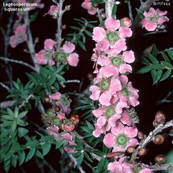 Along with Prostanthera, Leptospermum scrub covers the mountain tops of the Main Range in the Reserves. (Source: Australian Government: Department of the Environment and Water Resources)
 - Main Range.Vegetation of the region includes rain forest, tall open forest, woodland, tall scrubland and steep rock pavements. Rain forest is virtually restricted to altitudes above 700 m, on areas of fertile basalt soils. Cool subtropical rain forest predominates, of a type significantly different from the equivalent type found in the McPherson Range and Tweed Range. Small stands of warm temperate rain forest occur on sheltered southerly slopes to the south of the region. Above the cliffs the mountain top is covered with Leptospermum, Prostanthera scrub, with an unusual low forest (10 m) of Rapanea variabilis carrying a dense cover of epiphytic bryophytes.In exposed, elevated habitats along the Main Range, a lower form of closed forest occurs. A diversity of tall open forest communities occurs on the Main Range, dominated by various eucalypt species. A significant feature of the Main Range is the presence of "temperate" eucalypt species in the open forests at higher altitudes along the summit and western slopes, which reach the northern limit of their distribution here. Rocky heath communities include Helichrysum lindsayanum (R), and Wahlenbergia glabra (R). Two endangered (IUCN Red List Criteria for Endangered) species of the genus Marsdenia, M. coronata and M. longiloba occur within the property.
- Focal Peak Group.Cool subtropical rain forest comprises a major proportion of the vegetation of the western half of Mount Barney National Park, at higher altitud]s (greater than 600 m). Above 900 m on Mount Nothofagus and Mount Ballow, areas of cool temperate rain forest with Nothofagus moorei occur, representing the largest single stand of N. moorei in the Border Ranges area. Open forest communities occur in Mount Barney National Park, especially in the north-eastern section. E. michaeliana (R) has been recorded in the region.Of particular significance is the tall open forest with Eucalyptus oreades and associated montane heath shrublands. These include a range of narrow endemics and several rare and endangered species: Banksia conferta, Callitris monticola, Comesperma esulifolium, Coopernookia scabridiuscula, Helichrysum lindsayanum, H. whitei, Hibbertia monticola, Leucopogon sp. 'Mount Barney', Plectranthus alloplectus, Pultenaea whiteana, Rulingia salviifola, Wahlenbergia scopulicola and Westringia blakeana. Most of the vegetation in Mount Clunie Flora Reserve is rain forest, including subtropical rain forest, a small stand of warm temperate rain forest, and a significant stand of unlogged Araucaria cunninghamii rain forest. Ceratopetalum apetalum is absent from the warm temperate rain forest. A comprehensive description of vegetation types and species list is given in DASET (1992).
- Shield Volcano Group.Warm subtropical rain forest occurs on basalts at lower altitudes (less than 800 m) on Lamington Plateau and on lower mountain slopes. Of particular floristic significance are the stands of this rain forest type on basalt shelves and lower slopes within the Mount Warning erosion caldera, where numerous rare and threatened species occur. As the major rain forested creeks run downstream into broader, drier valleys a floristically distinct gallery fringe develops. At higher altitudes (800-1,100 m), warm subtropical rain forest is replaced by cool subtropical rain forest. In Lamington National Park, closed forests in which Ackama paniculata dominates the canopy, form an ecotone between cool subtropical and cool temperate Nothofagus rain forest.Araucarian vine forest or 'dry' rain forest, characterized by a discontinuous overstorey of hoop pine Araucaria cunninghamii, a species prized for its timber, occurs mainly at lower altitudes, although it can extend above 700 m. Many areas of Araucaria cunninghamii have been heavily logged and disturbed, but the largest unlogged stands are within the nominated property.Warm temperate rain forest approaches the northern limit of its distribution in this area, although there are structurally similar outliers in northern Queensland. This rain forest type is found mainly on sites that cannot support subtropical rain forest, either because of infertile soils (for example, on rhyolite rather than basic igneous rocks) or on windswept ridges where shallow soils and exposure to strong cool winds prevent the development of the more luxuriant subtropical rain forest. Cool temperate rain forest dominated by Nothofagus moorei reaches its northern limit in the nominated property.Although rain forest is the major vegetation type, there are also important stands of open forests, woodlands and shrublands. A number of shrub-dominated communities occur on exposed rock knolls and cliff lines. Montane heathlands are notable for their concentration of rare and restricted species. A detailed description of vegetation and species list is given in DASET (1992).
- Iluka Nature Reserve.The reserve contains the largest single stand in New South Wales of littoral rain forest, a distinctive coastal variant of sub-tropical rain forest, and the least extensive of all New South Wales rain forest types. The herb layer is generally sparse. East of the rain forest, on the most seaward dunes, is a characteristic East Coast dune flora with the pioneer grass Spinifex sericeus. As elsewhere along the coast, the introduced shrub Chrysanthemoides monilifera is a major component of the littoral fringe. To the west, the rain forest abuts Lophostemon - Eucalyptus open forest. The western edge of the rain forest is thought to be maintained in its present position by the incidence of fire in the woodland. A comprehensive description of the vegetation types, together with a list of plants recorded in the reserve is given in the World Heritage nomination document.
- Washpool and Gibraltar Range.The outstanding feature of this area is the diversity of plant communities and the mosaic of wet sclerophyll and rain forest communities. The major areas of rain forest are in Washpool National Park. Small areas of rain forest occur in Gibraltar Range National Park but many of these were subject to logging prior to its dedication. Warm temperate rain forest is the most extensively distributed form. Subtropical rain forest is restricted to more sheltered sites on better soils, while dry rain forest is very limited in extent. Despite the very high rainfall at high altitude, cool temperate rain forest is absent. The more extensive of the subtropical rain forest associations are of the cool type characterized by Sloanea woollsii, Dysoxylum fraserianum, Argyrodendron actinophyllum and Ackama paniculata, although stands are restricted to moist aspects in gully heads, protected from fire and on deep, moderately fertile soil. The major warm temperate rain forest association is a Ceratopetalum apetalum, Schizomeria ovata, Ackama sub alliance . Willowie Scrub in Washpool National Park is the largest extent of coachwood rain forest remaining in Australia and, therefore, the world.Wet sclerophyll forest, frequently with a well-developed rain forest understorey, is an outstanding feature of both national parks. At high altitudes along ridges the dominant eucalypt is Eucalyptus campanulata, with E. microcorys, E. saligna and Lophostemon confertus communities at lower altitudes. Wet and dry heathland is restricted to steep rocky outcrops at high altitudes. Several species of the heathland communities are endemic to the Gibraltar Range. Natural grasslands, occupying frost hollows and sedge swamps, occur in Gibraltar Range National Park and in the southernmost part of Washpool National Park. A comprehensive vegetation description and species list is given in DASET (1992).
- New England Group.The two parks contain a great variety of habitats over a wide range of altitudes. Conditions on the high, cold, windswept and frequently mist shrouded plateau margins contrast starkly with the warm, sheltered environments of the lower river valleys. These two extremes have few species in common.The region is one of the four distribution centers for Nothofagus moorei, which predominates in cool temperate rain forest. Other vegetation types present comprise: subtropical rain forest; warm temperate rain forest; wet sclerophyll rain forest; tall open eucalypt forest; intermediate subtropical/warm temperate rain forest; subalpine heath, extensive grasslands and swamp.A number of rare species are present, particularly in Dorrigo National Park, including Bosistoa floydii (R) and Backhousia anisata (R).
- Hastings-Macleay Group.The vegetation is extremely diverse and includes cool temperate, warm temperate, sub-tropical and dry rain forest, a range of eucalypt dominated communities as well as heath and swamp.In the cool temperate rain forest, which contains some of the largest Nothofagus trees in existence, there is often a well-developed understorey of warm temperate species. The two major warm temperate rain forest associations in the area, substantial areas of which remain in unmodified condition, are a Ceratopetalum - Doryphora sub-alliance and Ceratopetalum/Schizomeria-Argyrodendron/Sloanea sub-alliance . In Mount Seaview Nature Reserve, warm temperate rain forest at the head of Cedar Creek is notable for the absence of Ceratopetalum.Lowland subtropical rain forest is not abundant but a small stand is located in Mount Seaview Nature Reserve. This reserve also has an important stand of dry rain forest. The higher altitude form of subtropical rain forest, with Sloanea woollsii as a prominent species, is found at the heads of sheltered valleys below the plateau to the east of Forbes River.Dry rain forest communities dominated usually by Backhousia sciadophora are found in five protected gullies in Oxley Wild Rivers National Park and the Kunderang Brook section of Werrikimbe National Park. In the steeper, rockier sections of the gorges, vine thickets grow. The Castles Flora Reserve includes one of the few occurrences of rain forest on limestone in New South Wales.A wide variety of wet and dry sclerophyll communities are present within the reserves. The single most important commercial hardwood species in northern New South Wales is blackbutt Eucalyptus pilularis, which is predominant over a range of understoreys varying from wet to dry sclerophyll forest. Unlogged stands of blackbutt are rare, however a good example of unlogged blackbutt forest is preserved in Mount Seaview Nature Reserve.The drier blackbutt community occurs at lower altitudes on the northern slopes of Mount Banda Banda. The plateau supports: an open forest comprising a range of eucalypts and collectively referred to as New England hardwoods; swamps; grassland and areas of heath and scrub.Threatened or rare species not already mentioned include Callitris oblonga (V), Sarcochilus fitzgeraldii (V) and S. hartmanii (V).
- Barrington Tops Area.The park contains an unsurpassed series of gradations between various sclerophyll and rain forest types in response to factors such as altitude, aspect, soil type, rainfall and fire history. The major rain forest forms are subtropical and cool temperate, with relatively smaller areas of warm temperate rain forest.Lower altitude subtropical rain forest is well-developed in the south-eastern slopes of the plateau. On the alluvial flats of Boonabilla Creek a very different type of subtropical rain forest has developed. Colonising and late secondary successional species are present, indicating major disturbance in the past. Subtropical rain forest occurs at higher altitudes (up to 1,000 m), and contains a large element of warm temperate rain forest species. A curious features of the area is the virtual absence of what is normally one of the major species of warm temperate rain forest, Ceratopetalum apetalum.Towards the heads of the valleys subtropical elements mingle with cool temperate rain forest. Barrington Tops mark the southern limit of Nothofagus moorei, with stands also occurring in Kerripit Beech Flora Reserve. Wet sclerophyll forest types include a Eucalyptus saligna - E. quadrangulata association, which is widespread on valley slopes and often merges with rain forest or rain forest understorey. At high altitudes, normally on more fertile soils and associated with Nothofagus, tall forests of E. obliqua and E. fastigata occur. On drier slopes, E. campanulata - E. biturbinata - E. canaliculata - E. propinqua is predominant. On the plateau, subalpine woodlands are a ssociated with an extensive series of open swamps. Open grassy areas (grassland balds), believed to be of natural origin, feature at the summits of a number of peaks.The Barrington Tops region marks the northern or southern distribution limits of a number of species. Of considerable scientific interest is the rare endemic Tasmannia purpurascens, among the most primitive of living angiosperms. A recently described species, T. glaucifolia , is restricted to Barrington Tops and near Point Lookout in New England National Park. Other threatened or rare species include Dendrobium tenuissimum, Plantago cladarophylla and P. palustris.
A comprehensive description of vegetation types, and list of vascular plants recorded throughout the nominated sites is given in Appendix 1 of the nomination document. A list of rare, endangered (IUCN Red List Criteria for Endangered) and poorly known species recorded from the nominated sites is given in Table 7 of the nomination document.
Fauna
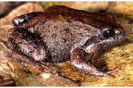 Philoria kundagungan is one of forty five species of frogs that can be found in the reserves. (Source: University of California at Berkeley)
 The nominated area has a rich and diverse fauna, for some groups the most diverse in Australia. More than 20 vertebrate species have the major part of their distribution in the nominated property, and numerous invertebrate species are confined to the nominated property. Forty five species of frog are present, several of which have distributions restricted largely to the nominated property. These include Assa darlingtoni, Philoria kundagungan, P. loveridgei, P. sphagnicolus, two unidentified species of Philoria sp., Mixophyes fleayi, Litoria booroolongensis, L. pearsoniana and L. subglandulosa. Reptile species number around 110. Genera largely restricted to the region include Phyllurus among the geckoes, Gonocephalus among the dragons, eight genera of skink, and Cacophis and Tropidechis among the snakes. Several species have the major part of their distribution within the rain forest and wet sclerophyll forests of the region in which the nominated property occurs.
The avifauna is the most diverse of any area in Australia, 270 species having been recorded. Of particular importance are Albert's lyrebird Menura alberti, the superb lyrebird M.novaehollandiae and rufous scrub-bird Atrichornis rufescens, both of which represent families with only two species, and are endemic to Australia. Albert's lyrebird is essentially confined to the Tweed Volcano/Border Ranges locality. Most vertebrate animals however, occur in sites throughout the nominated area. A total of 75 species, or 30% of Australia's terrestrial mammals have been recorded for the nominated sites. These include two species of monotremes, 32 marsupial species, 31 bat species and 10 species of rodent. At least 30 species inhabit rain forest and wet sclerophyll forest, of which at least one-third are largely confined to these habitats. Although no mammal species are restricted to the nominated property, the region represents the major part of the distribution of the parma wallaby and Hasting River mouse.
Invertebrates are highly diverse, and include many which are endemic to the region, due to the presence of both temperate and tropical elements. Land snail diversity is remarkably high, even by world standards. Insect fauna is very rich, second only in Australia to that of the Wet Tropics of Queensland World Heritage Property.
Cultural Heritage
The history of Aboriginal use of the subtropical rain forests appears to have commenced at about 9,000 to 10,000 years BP, shown by the occupation of Bushrangers Cave, which lies within the nominated property. Aboriginal hunter-gatherers appear to have used the subtropical rain forest as one of a number of diverse habitats within their tribal range, primarily for gathering food, rather than as a place to live. Food gathering appears to have caused very minor disturbances to the ecosystem. In contrast, the use of fire as a traditional land management tool had more dramatic consequences. The complex rain forest boundaries documented in early historic records appear to have been an artefact of traditional Aboriginal land management practices. Some of the main geographical features of the Border Ranges area are regarded as sacred by Aboriginal communities. On the southern rim of the Mount Warning crater, rhyolite cliffs have been undercut forming rockshelters.
Local Human Population
None.
Visitors and Visitor Facilities
Access roads, picnic sites and limited basic camping facilities are available in many sites. Information leaflets outlining these facilities are available for many of the parks. Dorrigo National Park and the Natural Bridge section of Springbrook National Park, with more than 150,000 visitor days per year, are the most heavily visited parts of the property.
Scientific Research and Facilities
Early colonial administrators employed official botanists to record and document the resources of the continent including the rain [[forest]s]. Surveys of rain forest fauna, particularly reptiles and amphibians, have been undertaken in rain forest areas in New South Wales. Surveys and research are continuing.
Conservation Value
The sites contain a great variety of vegetation types and endemic and rare plant and animal species, in a largely undisturbed state. Important geological features are included, notably the Shield Erosion Caldera and the Great Escarpment.
Conservation Management
Status of management plans for individual parks and reserves in the Central Eastern Rainforest Reserves (Australia) at February 1996.
New South Wales
Border Ranges NP; Nightcap NP; Limpinwood NR; Numinbah NR: Joint plan of management adopted 1989
Mt Warning NP: Plan of management adopted 1985
- Tooloom NP: No plan prepared
- Toonumber NP: No plan prepared
- Washpool NP; Gibraltar Range NP: Joint draft plan has been publicly exhibited
- New England NP: Plan of management adopted in 1990
- Dorrigo NP: Draft plan of management prepared
- Oxley Wild Rivers NP: Draft plan of management prepared
- Werrikimbe NP: Draft plan of management prepared
- Barrington Tops NP: Draft plan has been publicly exhibited, is being prepared for adoption
- Iluka NR: Draft plan publicly exhibited early 1996
- Mount Hyland NR: No plan prepared
- Mount Seaview NR: No plan prepared
Flora reserves
Working plans have been adopted for all flora reserves within the World Heritage Area.
Queensland
National Parks
A draft management framework has been prepared for the national parks of the Scenic Rim. Draft plans of management for Springbrook, Lamington, Mount Barney and Main Range in preparation.
State Forests
No planning is in train for state [[forest]s].
No significant developments are planned for the nominated property. Provision of visitor facilities, access, management infrastructure, and similar works is subject to management planning processes.
Grazing of domestic stock is permitted in one area of 249 ha in open forest on the Main Range; the permit expires in 2016. State forest trial plantations of indigenous and wild species exist at a few sites on the Main Range, but occupy only small areas and do not appear to be regenerating into adjacent native forest. Biological control agents for Bitou Bush have been released in the vicinity of Iluka Nature Reserve. Control measures to halt the spread of mist flower, Kahill ginger and madeira vine have been undertaken in Dorrigo National Park.
Management Constraints
Feral pigs are of significant concern on the Main Range, for which trapping and other control programs have been established. Broom is amajor concern in the open [[forest]s] and grasslands of Barrington Tops. Bitou bush is a major threat at Iluka Nature Reserve. Visitation pressure is becoming a problem in parts of Lamington and Springbrook National Parks. Part of Barrington Tops National Park is managed jointly with Hunter Water Corporation to ensure an unpolluted water supply to Lake Chichester.
Staff
No information.
Budget
No information.
IUCN Management Category
- Ia (Strict Nature Reserve) Ib (Wilderness)
- II (National Park)
- Natural World Heritage Site - Criteria i, ii, iv
Further Reading
- Adam, P. (1987). New South Wales Rainforests - the nomination for the World Heritage List. New South Wales Parks and Wildlife Service, Hurtsville.
- DASET (1992). Nomination of Central Eastern Rainforests of Australia for inclusion on the World Heritage List. Department of the Arts, Sport the Environment and Territories. 209 pp.
- DASET (1993). Australia's World Heritage Properties 1991 - 1992 Monitoring Report. Department of the Arts, Sport the Environment and Territories.
- Forestry Commission (1989). Forest Preservation in State Forests of New South Wales. Research Note 47. 2nd Edition.
- Forestry Commission (1981). Proposed rain forest logging operation, Hastings catchment. Environment Impact Statement Report. Forestry Commission of New South Wales, Sydney.
- Hunter, J. (1991). Under the Canopy. New South Wales Parks and Wildlife Service, Hurtsville.
- NPWS (1987). Border Ranges National Park, Nightcap National Park, Numinbah Nature Reserve, and Limpinwood Nature Reserve Draft Plan of Management. National Parks and Wildlife Service, New South Wales, Sydney 1987. 45pp.
- NPWS (n.d.). Park leaflets produced for each park. National Parks and Wildlife Service
- NPWS (1981). Proposed forest operations in the Hastings catchment. Submission on Environmental Impact Statement. National Parks and Wildlife Service of New South Wales, Sydney.
| Disclaimer: This article is taken wholly from, or contains information that was originally published by, the United Nations Environment Programme-World Conservation Monitoring Centre (UNEP-WCMC). Topic editors and authors for the Encyclopedia of Earth may have edited its content or added new information. The use of information from the United Nations Environment Programme-World Conservation Monitoring Centre (UNEP-WCMC) should not be construed as support for or endorsement by that organization for any new information added by EoE personnel, or for any editing of the original content. |