Celebes Sea
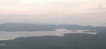
Ragged Sabah coastline of the Celebes Sea, viewed from low altitude aircraft. @ C.Michael Hogan
Seas of the World ![]() The Celebes Sea, an element of the western Pacific Ocean, is bordered on the north by the Sulu Archipelago, the Sulu Sea and Mindanao Island of the Philippines; on the east by the Sangihe Islands chain; on the south by Sulawesi, and on the west by the Kalimantan region in Indonesian Borneo and the southeastern coast of Sabah in Malaysian Borneo. The Celebes Sea has dimensions of about 675 kilometres north-south by 840 kilometres east-west, and exhibits a total surface area of approximately 280,000 km², to a maximum depth of 6200 metres.
The Celebes Sea, an element of the western Pacific Ocean, is bordered on the north by the Sulu Archipelago, the Sulu Sea and Mindanao Island of the Philippines; on the east by the Sangihe Islands chain; on the south by Sulawesi, and on the west by the Kalimantan region in Indonesian Borneo and the southeastern coast of Sabah in Malaysian Borneo. The Celebes Sea has dimensions of about 675 kilometres north-south by 840 kilometres east-west, and exhibits a total surface area of approximately 280,000 km², to a maximum depth of 6200 metres. 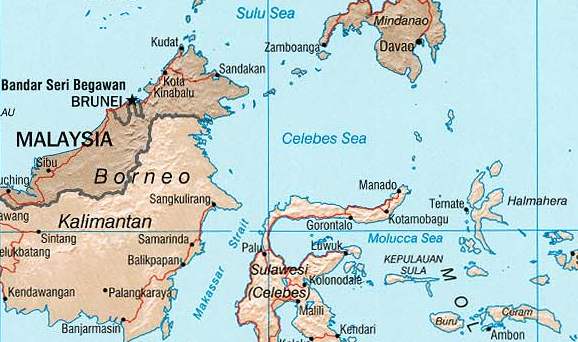 Celebes Sea. Source: CIA World factbook
The sea opens southwest through the Makassar Strait into the Java Sea.
The Celebes Sea is a portion of an ancient ocean basin that formed 42 million years ago in a setting far from any land mass. By 20 million years ago, crustal movement had pushed the Celebes basin sufficiently close to Indonesian and Philippine volcanoes to receive volcanic debris. By ten million years before present, the Celebes Sea was inundated with continental debris, including coal, which was shed from a rapidly growing young mountain on Borneo, and, by that era, the Celebes basin had docked against Eurasia.
The border between the Celebes and the Sulu Sea is construed to be the Sibutu-Basilan Ridge. Robust ocean currents, deep sea trenches and seamounts, combined with active volcanic islands, ha resulted in complex oceanographic topographic features for the Celebes basin.
Contents
Hydrography and Circulation 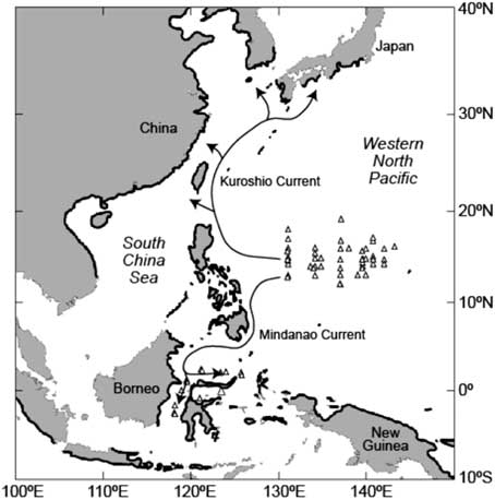 Mindinoa Current. Source: Aoyama
The prevailing circulation of the Celebes Sea is driven by input flow from the Mindinoa Current, resulting in an anti-clockwise movement of water within the Celebes basin.
This Mindinoa Current influx is maximal from December through May. Efflux from the Celebes Sea through the Makassar Strait is highest in the August to November time-frame, in which time window the southeasterly monsoons are most active. This water efflux is split, with a portion entering the Banda Sea and a portion flowing through the Lombok Strait into the Indian Ocean, with little resulting influence on the equatorial currents.
Limits
The International Hydrographic Organization (IHO) defines the Celebes Sea as being one of the waters of the East Indian Archipelago. The IHO depicts the extent as follows
- At the north. The southern limit of Sulu Sea [[Tagolo Point, down the west coast of Mindanao to the Southwest extremity thence to the north coast of Basilan Island (6°45′N 122°04′E / 6.75°N 122.067°E / 6.75; 122.067), through this island to its southern extremity, thence a line to Bitinan Island (6°04′N 121°27′E / 6.067°N 121.45°E / 6.067; 121.45) off the Eastern end of Jolo Island, through Jolo to a point in long. 121°04'E on its southern coast, thence through Tapul and Lugus Islands and along the north coast of Tawitawi Island to Bongao Island off its Western end (5°01′N 119°45′E / 5.017°N 119.75°E / 5.017; 119.75), and from thence to Tanjong Labian, the Northeastern extreme of Borneo]] and the southwest coast of Mindanao. On the East. A line from Tanjong Tinaka, the southern point of Mindanao, to the North point of Sangi (3°45′N 125°26′E / 3.75°N 125.433°E / 3.75; 125.433) thence through the Sangi Islands to Tanjong Poeisan, the northeast extreme of Celebes [Sulawesi].
- At the south. The North coast of Celebes between Tanjong Poeisan and Stroomenkaap (Cape Rivers) (1°20′N 120°52′E / 1.333°N 120.867°E / 1.333; 120.867) and thence a line to Tanjong Mangkalihat in Borneo, the Northern limit of Makassar Strait Line joining Tnjong Mngkliht, Borneo (1°02′N 118°57′E / 1.033°N 118.95°E / 1.033; 118.95) nd Stroomen Kp (Cpe Rivers), Celebes (1°20′N 120°52′E / 1.333°N 120.867°E / 1.333; 120.867).
- At the west. The East coast of Borneo between Tanjong Mangkalihat and Tanjong Labian, the southern limit of the Sulu Sea.
Marine Ecology
See main article: Sulu-Celebes Sea Large Marine Ecosystem
The Celebes Sea is habitat to a wide variety of fish and aquatic creatures. The tropical temperature and clear waters permit it to harbour about 580 of the world's 793 species of reef-building corals, which grow as some of the most bio-diverse coral reefs in the world, and an expansive array of marine organisms, including cetaceans, sea turtles, manta rays, eagle rays, barracuda, marlin and other reef and pelagic species. Tuna species, including yellowfin tuna, are also prolific here. In addition to high abundance of fish caught in the Celebes sea, this sea also yields other aquatic species such as sea tang. The southern limit of the Celebes Sea is Kalasey Beach in Bunaken Island, North Sulawesi.
The video below is from a 2007 research expedition supported by the U.S. National Oceanic and Atmospheric Administration (NOAA) for new species aboard the RV Presbitero which began in the port of Manila and then south through the Sulu Sea to a study site in the Celebes Sea, southeast of the Sulu Archipelago.
Terrestrial Ecology
See main article: Borneo Lowland Rainforests
A key terrestrial margin of the Celebes Sea is comprised of the Borneo Lowland Rainforests. These lowland dipterocarp rainforests are deemed by many as the biologically richest rainforests in the world, rivalling the biodiversity of New Guinea and the Amazon. With 267 Dipterocarpaceae species (155 endemic to Borneo), Borneo is the center of the world's diversity for dipterocarps. These forests are home to the world's smallest squirrel, the eleven centimetre long pygmy squirrel, and the endangered orangutan. In northeast Borneo, populations of Sumatran rhinoceros and Asia's largest terrestrial mammal, the Asian pygmy elephant, tenuously survive in the last pockets of forest. These forests contain the parasitic plant Rafflesia arnoldii, which produces the world's largest flower (up to one metre in diameter). These forests are globally outstanding for both bird and plant richness, with more than 380 birds and an estimated 10,000 plant species found within its boundaries. These forests have been rapidly converted to oil palm plantations or commercially logged at unprecedented rates over the past fifteen years. In 1997-1998 fires intentionally set to clear the forest for commercial agriculture such as oil palm ravaged Kalimantan
Commercial and Military Role
The Celebes Sea has been an important route for exploration and military action in Southeast Asia. In the Japanese invasion of this region during World War II, the Celebes Sea was invaded by Japanese destroyers, cruisers and submarines, who achieved initial control over the sea lanes; this presence resulted in the destruction of large numbers of civilian and commerical ships, with large numbers of civilian casualties; these commercial and civilian ship whose hulls now lie on the sea bottom. Later the allies led by USA and British forces, both naval and air support, exacted extensive damage on the Japanese military naval fleet, with an outcome of numerous Japanese warships sunk in these waters.
The Celebes Sea is deemed a significant modern transport route for trade and commerce in Southeast Asia. Furthermore, it is a notable venue for recreational deep sea diving and luxury ocean holiday cruising.
Piracy and Crime
The Celebes Sea has attained an international notoriety for its present day pirates who attack both small fishing craft, as well as large commercial cargo ships. The pirates utilize high-technology weaponry and equipment such as radar and GPS navigation devices and use high-speed motorboats. It is currently the second-most pirated body of water after the Gulf of Aden off of the coast of Somalia.
References
- Jun Aoyama, Life History and Evolution of Migration in Catadromous Eels (Genus Anguilla), Aqua-BioSci. Monogr. (ABSM), Vol. 2, No. 1, pp. 1–42 (2009) doi:10.5047/absm.2009.00201.0001
- Gerold Siedler, John Church, John Gould. 2001. Ocean circulation and climate: Observing and modelling the global ocean. Academic Press, 715 pages
- John H. Steele, Steve A. Thorpe, Karl K. Turekian. 2009. Ocean Currents: A Derivative of the Encyclopedia of Ocean Sciences. Academic Press. 612 pages
- International Hydrographic Organization. 1953. Limits of Oceans and Seas, 3rd edition.
- Department of Fisheries, Food and Agriculture Organization of the United Nations. 1972. Atlas of the living resources of the sea. Rome. ISBN: 9250010001.
- Thia-Eng, Chua and J.A. Mathias (Editors). 1978. Coastal resources of West Sabah: An investigation into the impact of oil spill. Penerbit Universiti Sains Malaysia, Pulau Pinang, Malaysia. 296 pp.
- Jürgen Rohwer. 2005. Chronology of the war at sea, 1939-1945: the naval history of World War II. Naval Institute Press, 532 pages
- Global Ocean Associates,Celebes Sea in An Atlas of Oceanic Internal Solitary Waves (February 2004) Prepared for Office of Naval Research
- NOAA, Exploring the Inner Space of the Celebes Sea 2007