Caswell Basin (Bailey)
Contents
Lithology and Stratigraphy
This subsection contains recent alluvium.
]]
Geomorphology
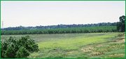
This subsection is on nearly level floodplain and basin floors, and on some alluvial fans along the western edge of the subsection. The subsection elevation range is from less than 10 to about 60 feet. Fluvial erosion and deposition are the main geomorphic processes.
Soils
The soils are mostly Fluvaquentic Haploxerolls, Aquic Xerofluvents, and Cumulic Haplaquolls. There are small areas of Natrixeralfs, Durixeralfs, and Pelloxererts. The soils are mostly poorly drained and some are moderately well and well drained. Soil temperature regimes are thermic. Soil moisture regimes are mostly aquic, and some are xeric.
Vegetation
The predominant natural plant communities are Emergent aquatic communities. Fremont cottonwood series occurs along streams. Valley oak series occurs on well and moderately well drained soils.
Characteristic series by lifeform include:
Climate
The mean annual precipitation is about 10 to 12 inches. It is practically all rain. Mean annual temperature is about 59° to 62° F. The mean freeze-free period is about 250 to 275 days.
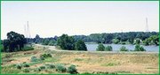
Surface Water
The San Joaquin River overflows onto this area. The subsection is drained by the San Joaquin River and its overflow channels. There are no permanent lakes.