Carnarvon xeric shrublands
| Topics: |
Geology (main)
|
Monkey Mia, Western Australia Photograph by M. Brauwer
The Carnarvon xeric shrublands ecoregion in western Australia lies within the deserts and xeric shrubliands biome. Considered as a Critical/Endangered ecoregion, the land area of this unit approximates 34,900 square miles (89,500 square kilometres). There are approximately 600 kilometers of coastline along the Indian Ocean that form the western limit of the ecoregion, which as a whole is classified as a G200 area.
The Carnarvon is comprised of two sub-regions:-
- Wooramel sub-region in the south, a key part of which is the Shark Bay World Heritage Area
- Cape Range sub-region in the north
Location and General Description
The Carnarvon xeric shrublands is bordered by the Indian Ocean to the west; from the Peron Peninsula in Shark Bay up to the North West Cape. The Pilbara shrublands lie to the northeast, the Western Australian Mulga shrublands to the east; and to the south the Southwest Australia savanna. The region is named after the coastal town of Carnarvon, and a number of [[coastal] ]towns and tourist resorts lie within the Carnarvon xeric shrublands ecoregion.
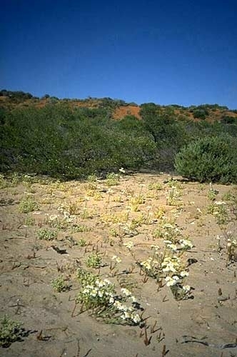
The ecoregion's topography is chiefly low-lying, and the plantlife varies with the underlying geology, which is primarily comprised of recent alluvial, aeolian, and marine sediments over cretaceous strata. This ecoregion is extremely arid, claiming less than 250 millimetres of total precipitation per annum..
The Carnarvon is also referred to physiographically as part of the Carnarvon Basin, essentially a physiographic province of the larger West Australian Shield division.

Cape Range sub-region
The Cape Range itself is the outcome of gradual uplifting from the sea floor accompanied by fluctuating sea levels, wind and water erosion which processes have slowly eroded the range and plain leaving a residual range of rugged limestone, deep canyons and unspoiled coastal backshores.
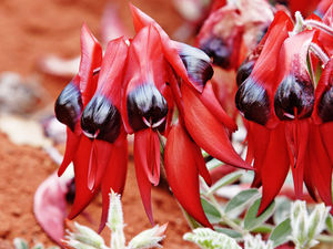 Sturt's desert pea is found in the Carnarvon ecoregion and beyond. Fir0002/Flagstaffotos The Cape Range s the only elevated plateau consisting of limestone on the entire northwestern coast of Australia. The montain range exhibits plateaus attaining elevations of up to 315 meters; moreover, this montane area is the geomorphic backbone of the whole peninsula, and it extends are far as North West Cape.
A portion of the Cape Range is protected as the Cape Range National Park; within the National Park flows Yardie Creek, a scenic gorge where the watercourse is dammed by a permanent sandbar. Within the Cape Range National Park are over 700 karst caves; moreover, in excess of 630 herbaceous plant species have been recorded in the park, including the Sturt's desert pea (Swainsona formosa) and the the green birdflower (Crotalaria cunninghamii).
Wooramel sub-region
The Wooramel sub-region features its crown jewel, the Shark Bay World Heritage Site, a locus of great significance for its claim to the largest seagrass expanse in the world. Marine resources here include a notable population of dugongs (Dugong dugon). Shark Bay also exhibits a remarkable occurrence of stromatolltes, coastal limestone deposits formed by cyanobacteria colonies that have been trapping sediment for thousands of years to gradually build these rocklike formations.
Biodiversity features
 Leporillus apicalis, critically endangered mammal, whose last refuge may be in the Carnarvon eoregion. Source: John Gould, F.R.S., Mammals of Australia Covering the saline alluvial plains are chiefly low samphire and saltbush shrublands, with snakewood scrublands upon the clay flats; Bowgada low woodland covers sandy ridges and plains, red sand dune fields are interspersed or overlain with tree to shrub steppe over hummock grasslands, and Acacia startii-A. bivenosa shrublands cover limestone outcrops at the north. Other tree species in the ecoregion include limestone wattle (Acacia sclerosperma) with an undergrowth of dead finish (Acacia tetragonophylla). The sheltered embayments and expansive tidal flats along the [[coastal] zone] support mangroves.
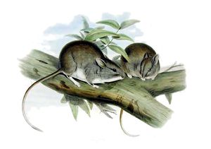
Fauna of the ecoregion include birds such as the Thick-billed grasswren (Amytornis textilis) and the Australian endemicred-tailed black cockatoo (Calyptorhynchus banksii). This locale is thought to be the sole possible habitat for a surviving population of the lesser stick-nest rat, which is otherwise potentially extinct. If this small mammal still survives, the most likely habitat may be one of the unexplored karstic caves of the eoregion.
Human population
There are only about 10,000 people resident in this ecoregion, most of whom are aborigines. The Carnarvon makes up most of the land area of the Gascoyne, which is one of the nine administrative divisions of West Australia.
Current status
The Carnarvon xeric shrublands ecoregion is deemed to be a Critical/Endangered ecoregion.
Type and severity of threats
Threats to the ecoregion include overgrazing as well as oil and gas resource development, the latter of which could eventually bring an expanded human population to the ecoregion.
Justification of ecoregion delineation
The Carnarvon Xeric Shrublands ecoregion comprises the Carnavon unit within the Interim Biogeographic Regionalisation for Australia, known as IBRA. (Thackway and Cresswell 1995).
References
- Thackway, R. and I. D. Cresswell. editors. 1995. An Interim Biogeographic Regionalisation for Australia: a framework for establishing the national system of reserves, Version 4.0. Australian Nature Conservation Agency, Canberra.
- Environment Australia. Revision of the Interim Biogeographic Regionalisation for Australia (IBRA) and Development of Version 5.1 - Summary Report. Department of the Environment and Water Resources, Australian Government.
- Interim Biogeographic Regionalisation for Australia6.1 data
- Jonasson, Karina E. 2001. Western Australia atlas of petroleum fields. Volume 2. Perth, W.A. Dept. of Minerals and Energy W.A. Petroleum Division. ISBN 1-877065-00-5
- Stromatolites of Shark Bay. Nature fact sheets. Department of Environment and Conservation
- Western Australia. Department of Environment and Conservation.. 2007. Shark Bay terrestrial reserves and proposed reserve additions: draft management plan 2007 Department of Environment and Conservation; Conservation Commission of Western Australia. Bentley, W.A.: Dept. of Environment and Conservation. pages 37-39 section Bioregions and Figure 4: IBRA sub-regions of the Shark Bay Area (map)