Burkina Faso
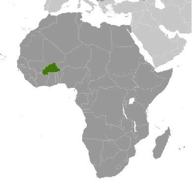
Countries and Regions of the World Collection  Burkina Faso is a landlocked nation of seventeen million people in western Africa, north of Ghana.
It is geographically in the Sahel--the agricultural region between the Sahara Desert and the coastal rain forests. Most of central Burkina Faso lies on a savanna plateau, 200 meters-300 meters (650 ft.-1,000 ft.) above sea level, with fields, brush, and scattered trees.
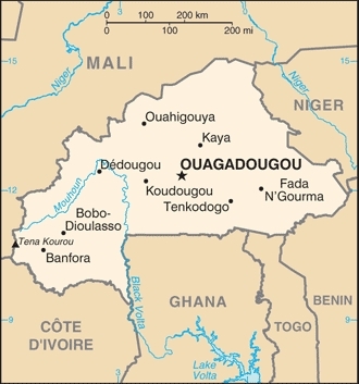
The country is mostly savanna cut by the three principal rivers of the Black, Red, and White Voltas. The largest river is the Mouhoun (Black Volta), which is partially navigable by small craft.
|
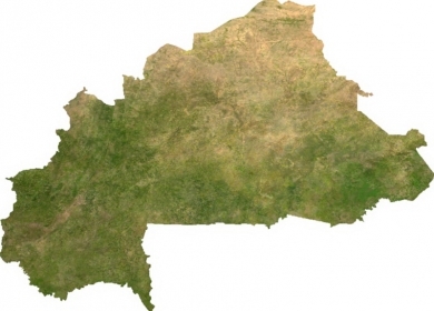
Source: NASA/The Map Library |
Burkina Faso has West Africa's largest elephant population. Game preserves also are home to lions, hippos, monkeys, warthogs, and antelope. Infrastructure and tourism are, however, not well developed.
Annual average rainfall varies from about 100 centimeters (40 in.) in the south to less than 25 centimeters (10 in.) in the north and northeast, where hot desert winds accentuate the dryness of the region. The cooler season, November to February, is pleasantly warm and dry (but dusty), with cool evenings. March-June can be very hot. In July-September, the rains bring a 3-month cooler and greener humid season.
Major environmental issues include:
recent droughts and desertification population distribution are severely affecting agricultural activities, population distribution, and the economy;
- overgrazing
- soil degradation; and,
- deforestation.
Burkina Faso (formerly Upper Volta) achieved independence from France in 1960.
Repeated military coups during the 1970s and 1980s were followed by multiparty elections in the early 1990s.
Current President Blaise Compaore came to power in a 1987 military coup and has won every election since then.
Burkina Faso's high population density and limited natural resources result in poor economic prospects for the majority of its citizens.
Recent unrest in Cote d'Ivoire and northern Ghana has hindered the ability of several hundred thousand seasonal Burkinabe farm workers to find employment in neighboring countries.
Despite the limited natural resources in this arid savannah, the nation experienced a 200 percent increase in urban population between 1975 and 2000.
Much of that growth occurred in the capital city of Ouagadougou, where unplanned settlements sprang up along the city’s perimeter. Between 1960 and 1993, Ouagadougou experienced a 14-fold increase in area.
Contents
Geography
Location: Western Africa, north of Ghana
Geographic Coordinates: 13 00 N, 2 00 W
Area: 274,200 km2 (273,800 km2 land and 400 km2 water)
arable land: 17.66%
permanent crops: 0.22%
other: 82.12% (2005)
Land Boundaries: 3,193 km. Border countries: Benin 306 km, Cote d'Ivoire 584 km, Ghana 549 km, Mali 1,000 km, Niger 628 km, Togo 126 km
Burkina Faso has issues concerning unresolved boundary alignments with its neighbors. Demarcation is currently underway with Mali, the dispute with Niger was referred to the ICJ in 2010, and a dispute over several villages with Benin persists Benin retains a border dispute with Burkina Faso around the town of Koualou.
Natural Hazards: recurring droughts
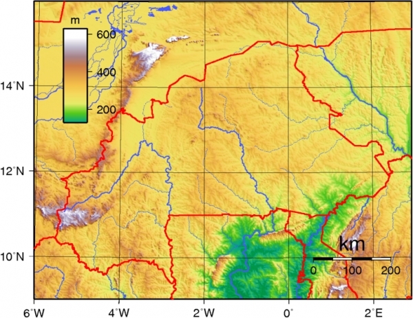
Terrain: Mostly flat to dissected, undulating plains; hills in west and southeast. Its' lowest point is Mouhan (Black Volta) River (200 metres) and its' highest point is Tena Kourou (749 metres).
Climate: Tropical; warm, dry winters; hot, wet summers
Topography of Burkina Faso. Source: Wikimedia Commons
Ecology and Biodiversity
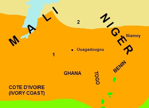
Except for the northern most portion of the country, Burkina Faso is covered by West Sudanian savanna [1], an ecoregion which stretches in a band across West Africa south of the Sahel, from Senegal and Gambia to the eastern border of Nigeria. It lies between the Guinean Forest-Savanna Mosaic to the south, and the Sahelian Acacia Savanna [2] to the north (which covers the remaining part of Burkina Faso). The West Sudanian savanna ecoregion is mainly flat and lies between 200 and 400 meters (m) in elevation with very few prominent topographical features. Protected areas in this ecoregion include the transboundary ‘W’ National Parks in Niger, Burkina Faso, and Benin.
People and Society
Population: 17,275,115 (July 2012 est.)
Ethnic groups: Mossi over 40%, other approximately 60% (includes Gurunsi, Senufo, Lobi, Bobo, Mande, and Fulani)
Burkina Faso is an ethnically integrated, secular state. Burkina Faso's people belong to two major West African cultural groups--the Voltaic and the Mande (whose common language is Dioula). The majority (60.5%) of Burkinabe are Muslim, but most also adhere to traditional African religions. Christians, both Roman Catholics and Protestants, comprise about 24% of the population, with their largest concentration in urban areas.
The dominant ethnic group is the Mossi, with the Voltaic Mossi making up about one-half of the population. The Mossi claim descent from warriors who migrated to present-day Burkina Faso from Ghana and established an empire that lasted more than 800 years. The group is mainly farmers and is led by the Mogho Naba (emperor of the Mossi kingdom), whose court is in Ouagadougou. The Mogho Naba is a revered figure who speaks with greater moral authority than any other Burkinabe and plays an important, informal role in fostering national harmony and dialogue.
Age Structure:
0-14 years: 45.8% (male 3,849,350/female 3,828,483)
15-64 years: 51.7% (male 4,320,779/female 4,334,197)
65 years and over: 2.5% (male 162,157/female 256,489) (2011 est.)
Population Growth Rate: 3.073% (2012 est.)
Birthrate: 43.2 births/1,000 population (2012 est.)
Death Rate: 43.2 births/1,000 population (2012 est.)
Net Migration Rate: 0 migrant(s)/1,000 population (2012 est.)
Life Expectancy at Birth: 54.07 years (2012 est.)
Total Fertility Rate: 6.07 children born/woman (2012 est.)
With a continued high average fertility rate of 6 children per woman of reproductive age, total national population is projected to grow to 21.5 million in 2020. While the average annual national population growth rate is 3.1%, urban areas are growing by over 10% per year. Nearly 65% of population is less than 25 years old. The average population density is 51.4 people per square kilometer (128/sq. mi), but in the center of the country it is about 80 people per square kilometer. Millions of Burkinabe reside in other countries, especially Cote d'Ivoire and Ghana.
Languages: French (official), native African languages belonging to Sudanic family spoken by 90% of the population
Literacy: 21.8% (male: 29.4% - female: 15.2% Est.)
Few Burkinabe have had formal education. Schooling is in theory free and compulsory until the age of 16, but only about 80.3% of Burkina's primary school-age children are enrolled in primary school. Of those enrolled, only about 41.7% complete primary school. The University of Ouagadougou, founded in 1974, was the country's first institution of higher education. The Polytechnical University in Bobo-Dioulasso was opened in 1995. The University of Koudougou was founded in 2005 to substitute for the former teachers' training school, Ecole Normale Superieure de Koudougou.
Urbanization: 26% of total population (2010) growing at an annual rate of change of 6.2% (2010-15 est.)
History
Until the end of the 19th century, the history of Burkina Faso was dominated by the empire-building Mossi. The French arrived and claimed the area in 1896, but Mossi resistance ended only with the capture of their capital Ouagadougou in 1901. The colony of Upper Volta was established in 1919, but it was dismembered and reconstituted several times until the present borders were recognized in 1947.
The French administered the area indirectly through Mossi authorities until independence was achieved on August 5, 1960. The first President, Maurice Yameogo, resigned in 1966 following continuous worker strikes and handed power over to Lt. Col. Sangoule Lamizana, who was head of a government of senior army officers. Lamizana remained in power throughout the 1970s, as President of military and then elected governments.
Following more worker strikes, Col. Saye Zerbo overthrew President Lamizana in 1980. Colonel Zerbo also encountered resistance from workers’ unions and was overthrown 2 years later by Maj. Dr. Jean-Baptiste Ouedraogo and the Council of Popular Salvation (CSP). Factional infighting developed between moderates in the CSP and radicals led by Capt. Thomas Sankara, who was appointed Prime Minister in January 1983, but was subsequently arrested. Efforts to bring about his release, directed by Capt. Blaise Compaore, resulted in yet another military coup d'etat, led by Sankara and Compaore on August 4, 1983.
|
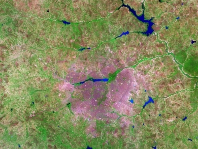
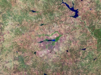
Over the years, NASA’s Landsat satellites have observed the increase in Ouagadougou’s extent. The Landsat 7 satellite captured the top image on October 16, 2006, and the Landsat 5 satellite acquired the bottom image on November 18, 1986. In these false-color images, vegetation appears bright green, bare or sparsely vegetated ground ranges in color from beige to gray-green, and water ranges in color from navy to electric blue. Paved surfaces and buildings appear pink-purple. The 2006 image shows how urbanization radiated out from the city center, filling nearly the entire frame. Urbanization has increased especially in the east and south; in the 1986 image, random shapes of green and brown fill the area; in the 2006 image, that area is predominantly pinkish purple. Likewise, a crooked line of vegetation that is visible north of Bois de Boulogne in 1986 has all but disappeared in 2006. In both images, the Ouagadougou airport appears as a conspicuous diagonal line near the center of the image. In 1986, the airport lies fairly close to the city’s outskirts. In 2006, continued urbanization has surrounded the airport with cityscape. Southwest of the airport, the beginnings of urbanization appear in 1986, and that urbanization is more pronounced in 2006. Lakes and rivers near the top and right edges of the image show different colors between 1986 and 2006; the color change likely results from differences in sediment or organic matter suspended in the water. In 2008, the United Nations Environment Programme (UNEP) published Africa: Atlas of Our Changing Environment highlighting changes detected by remote sensing, and providing overviews of each nation’s progress toward environmental sustainability in the late twentieth and early twenty-first century. UNEP found that, in the 1980s, Ouagadougou’s growth resulted predominantly from rural-to-urban migration. After that time, the population increased primarily from natural growth—birth rates exceeding death rates. The growth led to an explosion of unplanned settlements. Unplanned settlements may conflict with sustainable development goals, and they make it harder for the government to provide basic services, such as drinking water. Despite growing urbanization, however, UNEP found that Burkina Faso made progress in some key areas of environmental sustainability. Protected areas increased slightly from 1990 to 2005, and per capita carbon dioxide emissions dropped slightly over roughly the same period. Meanwhile, access to better sources of drinking water and sanitation increased from 1990 to 2004, and the proportion of urban dwellers living in slums decreased slightly from 1990 to 2001. Nevertheless, water scarcity, desertification, and deforestation all threatened the country’s future health. Source: NASA. Credit: NASA image created by Jesse Allen, using Landsat data provided by the United States Geological Survey. Caption by Michon Scott. |
Sankara and Compaore established the National Revolutionary Committee with Sankara as President, and he vowed to "mobilize the masses." But the committee's membership remained secret and was dominated by Marxist-Leninist military officers. In 1984, Upper Volta changed its name to Burkina Faso, meaning "the country of honorable people." But many of the strict security and austerity measures taken by Sankara provoked resistance. Despite his initial popularity and personal charisma, Sankara was killed in a coup which brought Capt. Blaise Compaore to power in October 1987.
Compaore pledged to pursue the goals of the revolution but to "rectify" Sankara's "deviations" from the original aims. In fact, Compaore reversed most of Sankara's policies and combined the leftist party he headed with more centrist parties after the 1989 arrest and execution of two military officers, Major Jean-Baptiste Boukary Lingini and Captain Henri Zongo, who had supported Compaore and governed with him up to that point.
With Compaore alone at the helm, a democratic constitution was approved by referendum in 1991. In December 1991, Compaore was elected President, running unopposed after the opposition boycotted the election. The opposition did participate in the following year's legislative elections, in which the ruling party won a majority of seats.
The government of the Fourth Republic includes a strong presidency, a prime minister, a Council of Ministers presided over by the president, a unicameral National Assembly, and the judiciary. The legislature and judiciary are nominally independent but remain susceptible to executive influence. Given the fragile roots of democratic institutions, constitutional checks and balances are seldom effective in practice. Compaore and the CDP dominate the cabinet and all areas of government.
Burkina held multiparty municipal elections in 1995, 2000, and 2006, as well as legislative elections in 1997, 2002, and 2007. Balloting was considered largely free and fair in all elections despite minor irregularities. The Congress for Democracy and Progress (CDP), the governing party, won overwhelming majorities in all the elections, except for the 2002 legislative elections, where the CDP won with only a small majority of the 111 seats. Compaore won the November 1998 presidential election for a second 7-year term against two minor-party candidates. But within weeks of Compaore's victory, domestic opposition and civil society groups took to the streets to protest the December 13, 1998, murder of leading independent journalist Norbert Zongo, whose investigations of the death of the President's brother's chauffeur suggested involvement of the Compaore family. The Collective Against Impunity, including civil society groups, human rights associations, and opposition parties--led by human rights activist Halidou Ouedraogo and opposition political party leaders including the late Prof. Joseph Ki-Zerbo and (for a while) Hermann Yameogo, son of the first President--challenged Compaore and his government to bring Zongo's murderers to justice and make political reforms. The Zongo killings still resonate in Burkina politics, though not as strongly as in the past. There has been no significant progress on the investigation of the case. The case is not closed; it is suspended and can be re-activated until July 2016 if new information is brought before the courts. However, with the December 23, 2009 death of Chief Warrant Officer Marcel Kafando, sole suspect in the case, the case is de facto closed.
Compaore was re-elected to the presidency for a 5-year term in November 2005. Observers considered the election to have been generally free, despite minor irregularities, but not entirely fair due to the ruling party's control of official resources. The constitution had been amended in 2000 to limit the president to a 5-year term, renewable once, beginning with the November 2005 election. The amendment was controversial because it did not make any mention of retroactivity, meaning that President Compaore's eligibility to present himself for the 2005 presidential election, his third, was a matter of debate. The Constitutional Court ruled in October 2005 that the amendment was not retroactive, and Compaore went on to win the November 2005 presidential election with over 80% of the vote. Most international and national electoral observers believed that the election was fair.
In 2007, the CDP won a majority in the May legislative elections, which observers declared generally free and orderly despite irregularities including fraud involving voter identification cards. Observers agreed that the 2004 revision of the electoral code negatively impacted the 2002 gains of opposition political parties during the 2007 legislative elections.
Running against six opponents, President Compaore won the November 21, 2010 presidential elections with over 80% of the vote, with an estimated 55% voter turnout. Compaore’s current term is supposed to be his last, but there have been suggestions that he is preparing to change the constitution to remove limits on the number of terms a president can serve.
In spring 2011, Burkina Faso faced a combination of fast-breaking and largely unexpected civilian protests and rank-and-file military looting--some linked and some not--reflecting a long-simmering malaise and a deep-seated resentment of what many Burkinabe perceived as an entrenched and increasingly sclerotic “old guard.” In the aftermath, the government re-opened all educational institutions (which remain overcrowded, underfunded, and strike-prone), dormitories, and support services and met with representatives of student and military groups to hear their grievances and find solutions. President Compaore also replaced the Prime Minister, Chief of Defense, and security service chiefs and appointed new governors (mostly career civil servants) in all 13 states. On July 12, the government detained 217 ringleaders of several March-May mutinies and dismissed 566 participating soldiers, to public acclaim. Also in July, the National Assembly dissolved the National Electoral Commission (CENI) so that a new chairman could be appointed to lead CENI's preparations for 2012 legislative and municipal elections. The former chairman had refused to resign despite calls by the government and opposition for him to do so over his handling of the November 2010 polls. The opposition had threatened to withdraw its members from the CENI, which would have rendered it legally incapable of performing its duties. As of late July, the government’s actions had produced greater calm and stability.
Government
Government Type: parliamentary republic
Capital: Ouagadougou - 1.777 million (2009)
Administrative Divisions: 45 provinces; Bale, Bam, Banwa, Bazega, Bougouriba, Boulgou, Boulkiemde, Comoe, Ganzourgou, Gnagna, Gourma, Houet, Ioba, Kadiogo, Kenedougou, Komondjari, Kompienga, Kossi, Koulpelogo, Kouritenga, Kourweogo, Leraba, Loroum, Mouhoun, Nahouri, Namentenga, Nayala, Noumbiel, Oubritenga, Oudalan, Passore, Poni, Sanguie, Sanmatenga, Seno, Sissili, Soum, Sourou, Tapoa, Tuy, Yagha, Yatenga, Ziro, Zondoma, Zoundweogo
Independence Date: 5 August 1960 (from France)
Legal System: based on French civil law system and customary law. Burkina Faso has not submitted an International Court of Justice (ICJ) jurisdiction declaration; but accepts International Criminal Court (ICCt) jurisdiction
Foreign Relations
Burkina Faso has excellent relations with European aid donors. France and the European Union, in particular, provide significant aid. Other donors with large bilateral aid programs include Germany, Denmark, the Netherlands, Sweden, Switzerland, and Canada. Burkina Faso maintains relations with Libya, but they are tense. Burkina Faso recognizes Taiwan. President Compaore is active in sub-regional diplomacy in West Africa. He was elected in January 2007 to be Chairman of the Economic Community of West African States (ECOWAS) and has acted as a mediator in political crises in neighboring Togo and Cote d'Ivoire and, more recently, Guinea. From January 2008 to December 2009, Burkina Faso was a non-permanent member of the UN Security Council. Burkina also plays a role regional in peacekeeping operations, having sent two battalions and one company to Darfur, Sudan under a UNAMID/African Union mandate. As of July 2011 it deployed 1,048 peacekeepers to four UN missions (MINUSTAH, MONUSCO, UNMIS, and UNAMID).
International Environmental Agreements
Burkina Faso is party to international agreements on Biodiversity, Climate Change, Climate Change-Kyoto Protocol, Desertification, Endangered Species, Hazardous Wastes, Law of the Sea, Marine Life Conservation, Ozone Layer Protection, and Wetlands.
|
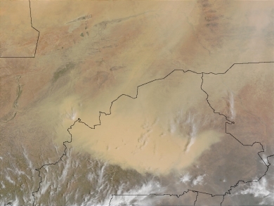
A massive dust storm in Burkina Faso (bottom center), has created an opaque, sandy shroud for the land locked West African country. The storm seems to be extending north into Mali and east into southwestern Niger. This image was acquired by MODIS on April 10, 2002. Source: NASA. Credit: Jacques Descloitres, MODIS Land Rapid Response Team, NASA/GSFC |
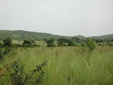
| Sahel savanna in SW Burkina Faso, near Gbomblora on the road from Gaoua to Batié. Source: Stefan Dressler/Wikimedia Commons |
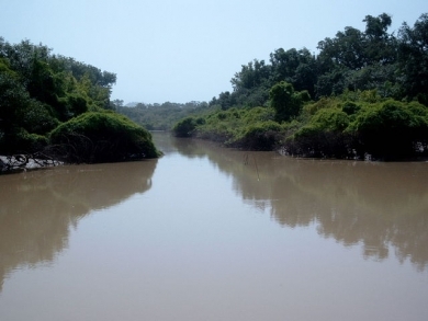
| View of the Arli river in the Arli National Park (Burkina Faso) near the rangers' station. (2002). Source: Marco Schmidt/Wikimedia commons |
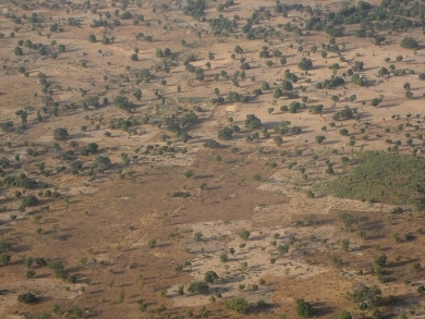
| Savanna west of Ouagadougou. Source: Wikimedia Commons |
Water
Total Renewable Water Resources: 17.5 cu km (2001)
Freshwater Withdrawal: Total: 0.8 cu km/yr (13% domestic, 1% industrial, 86% agricultural).
Per capita Freshwater Withdrawal:: 60 cu m/yr (2000)
Access to improved sources of drinking water: 76% of population
Access to improved sanitation facilities: 11% of population
Agriculture
Agricultural Products: cotton, peanuts, shea nuts, sesame, sorghum, millet, corn, rice; livestock
Irrigated Lands: 250 sq km (2003)
Resources
Natural Resources: manganese, limestone, marble; small deposits of gold, phosphates, pumice, salt.
Economy
Burkina Faso is a poor, landlocked country that relies heavily on cotton and gold exports for revenue.
The country has few natural resources and a weak industrial base.
About 90% of the population is engaged in subsistence agriculture, which is vulnerable to periodic drought. Cotton is the main cash crop.
Since 1998, Burkina Faso has embarked upon a gradual privatization of state-owned enterprises and in 2004 revised its investment code to attract foreign investment.
As a result of this new code and other legislation favoring the mining sector, the country has seen an upswing in gold exploration and production. By 2010, gold had become the main source of export revenue. Gold mining production doubled between 2009 and 2010 and two new mining projects were launched the third quarter of 2011.
Local community conflict persists in the mining and cotton sectors, but the Prime Minister has made efforts to defuse some of the economic cause of public discontent, including announcing income tax reductions, reparations for looting victims, and subsidies for basic food items and fertilizer.
An IMF mission to Burkina Faso in October 2011 expressed general satisfaction with the measures.
The risk of a mass exodus of the 3 to 4 million Burinabe who live and work in Cote D'Ivoire has dissipated and trade, power, and transport links are being restored.
Burkina’s economic and financial outlook offer reason for cautious optimism. Real GDP growth reached 7.9% for 2010, compared with 3.2% in 2009, but was expected to slow to 5.2% in 2011. The mining and the agricultural sectors (primarily cattle and cotton) are the main sources of growth. Despite popular perception that the cost of living has risen, inflation was -0.7% in 2010 and was expected to increase only slightly in 2011. The budget deficit increased from 4.8% of GDP in 2009 to 5.6% in 2010 because of an increase in investment spending. Official corruption is high but not extreme. Burkina Faso remains one of the world’s poorest countries, ranking 161 out of 169 countries in the 2010 UNDP Human Development Index, with a per capita gross domestic product (GDP) of $580. About 80% of the population relies on subsistence agriculture, with only a small fraction directly involved in industry and services. Drought, poor soil, lack of adequate communications and other infrastructure, a low literacy rate, and an economy vulnerable to external shocks (such as rising oil and food prices and the now-abating Ivoirian political crisis) are all longstanding problems. The government also faces pressure to increase spending to encourage calm following the social unrest that began in spring 2011. Burkina remains committed to the structural adjustment program it launched in 1991, and it has been one of the first beneficiaries of the World Bank/International Monetary Fund (IMF) debt-relief and poverty reduction programs for heavily indebted poor countries. Burkina Faso is recognized as a good development performer and partner. From 2008 to 2009, annual assistance amounts more than tripled to $1.3 billion, and annual per capita assistance was estimated in 2009 at $81. About 3 million to 4 million Burkinabe are migrant workers, many of whom work on cocoa farms in Cote d’Ivoire. Their remittances provide a contribution to the economy's balance of payments that is third only to gold and cotton as a source of foreign exchange earnings. Political and economic problems in Cote d'Ivoire have had a direct impact on this source of revenue for millions of Burkina households.
Burkina is attempting to improve the economy by developing its mineral resources, particularly gold, improving its infrastructure, making its agricultural and livestock sectors more productive and competitive, and stabilizing the supplies and prices of food grains. Staple crops are millet, sorghum, maize, and rice. The cash crops are cotton, peanuts, karite (shea nuts), and sesame. About 80% of the population relies on subsistence agriculture. Livestock, once a major export, has declined. Burkina Faso has increased its gold exports substantially over the past 3 years, with 7.8 tons exported in 2009; it was projected that up 20 tons could be exported in 2010. Burkina Faso is Africa’s largest producer of cotton, which employs 17% of the population and accounts for 5% to 8% of GDP and 60% to 70% of export earnings. In 2010, almost 80% of the cotton planted in Burkina Faso was grown from genetically modified seeds. Burkina is second only to South Africa as Africa’s largest producer of biotech crops (100% of it cotton), and had the world’s second-fastest growing acreage of biotech crops after Australia. The Monsanto Company remains a major partner in this endeavor.
Manufacturing is limited to cotton and food processing (mainly in Bobo-Dioulasso) and import substitution heavily protected by tariffs. Some factories are privately owned, and others are set to be privatized. Burkina Faso's investment code has helped to promote foreign investment. In the International Finance Corporation’s (IFC) Doing Business 2010 report, Burkina Faso ranked at 147 out of 183 countries, up from 155 in 2009 and 164 in 2008; this improvement reflects the country's successful efforts to create an environment conducive to business growth. Reforms include the adoption of a labor code in May 2008, improving the process to transfer property, the elimination of commune authorization requirements, the creation of a one-stop shop to facilitate construction permits, a decrease of the corporate tax rate from 35% to 30%, and a decrease on dividend taxes from 15% to 12%. Foreign investors, particularly in the mining sector, have taken note of this development; since 2007, four commercial gold mines and a manganese mine have been opened. Several others are slated to follow in the next few years. A railway connects Burkina with the port of Abidjan, Cote d'Ivoire, 1,150 kilometers (712 mi.) away. Primary roads between main towns in Burkina Faso are paved. Domestic air service and flights within Africa are limited. Phones and Internet service providers are relatively reliable, but the cost of utilities is very high.
GDP (Purchasing Power Parity): $21.83 billion (2011 est.)
GDP (Official Exchange Rate): $10.1 billion (2011 est.)
GDP-per capita (PPP): $1,500 (2011 est.)
GDP-composition by sector:
agriculture: 34.1%
industry: 23.2%
services: 42.8% (2011 est.)
Population Below Poverty Line: 46.4% (2004)
Industries: cotton lint, beverages, agricultural processing, soap, cigarettes, textiles, gold
Exports: cotton, livestock, gold
Imports: capital goods, foodstuffs, petroleum
Currency: Communaute Financiere Africaine franc (XOF);
Energy
| Production | Consumption | Exports | Imports | Reserves | |
| Electricity | 664.4 million kWh (2009 est.) |
683.5 million kWh (2008 est.) |
0 kWh (2009) |
144.6 million kWh (2009 est.) |
|
| Oil | 0 bbl/day (2010) |
9,000 bbl/day (2010 est.) |
0 bbl/day (2010) |
8,560 bbl/day (2009 est.) |
0 bbl (1 January 2011 est.) |
| Natural Gas | 0 cu m (2009 est.) |
0 cu m (2009 est.) |
0 cu m (2009 est.) |
0 cu m (2009 est.) |
0 cu m (1 January 2011 est.) |
| Source: CIA Factbook | |||||
