Bouvet Island
| Topics: |

Countries and Regions of the World Collection  Bouvet Island is a small uninhabited volcanic island in the South Atlantic Ocean, southwest of the Cape of Good Hope (South Africa). It almost entirely covered by glaciers and is difficult to approach.
Bouvet Island is a teritory of Norway, administered by the Polar Department of the Ministry of Justice and Oslo Police.
|
|
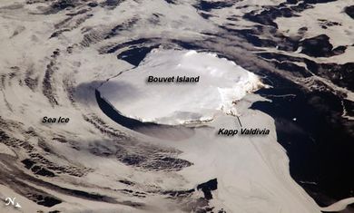 Photo courtesy of NASA. Photo courtesy of NASA.
|
|
|
|
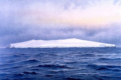
Bouvet Island, southeast side, as seen at sunrise, eight miles distant, November 26, 1898. Water color by F. Winter. P. 191. In: "Aus den Tiefen des Weltmeeres" by Carl Chun, 1903. Call No. Q115.V15 1903. Source: NOAA Photo Library |

Bouvet Island is one of the most remote islands in the world; Antarctica, over 1,600 km (1,000 mi) to the south, is the nearest land mass.
Located near the junction of three tectonic plates, the island is mostly formed from a shield volcano that is almost entirely covered by glaciers.
The prominent Kapp (Cape) Valdivia on the northern coastline is a peninsula formed by a lava dome. It is only along the steep cliffs of the coastline that the underlaying dark volcanic rock is visible against the white snow and ice blanketing the island.
Bouvet Island was discovered in 1739 by a French naval officer, Jean-Baptiste Charles Bouvet de Lozier, after whom the island was named.
No claim was made until 1825, when the British flag was raised. In 1928, the UK waived its claim in favor of Norway, which had occupied the island the previous year.
In 1971, Norway designated Bouvet Island and the adjacent territorial waters a nature reserve. Since 1977, it has run an automated meteorological station on the island.
Bouvet Island is home to Chinstrap, Adelie, and Macaroni penguins; and, Antarctic fur seal
Location: island in the South Atlantic Ocean, southwest of the Cape of Good Hope (South Africa)
Geographic Coordinates: 54 26 S, 3 24 E
Area: 49 sq km
Coastline: 29.6 km
Terrain: volcanic; coast is mostly inaccessible. The highest point is Olav Peak (935 m)
Climate: Antarctic