Bohai Sea saline meadow
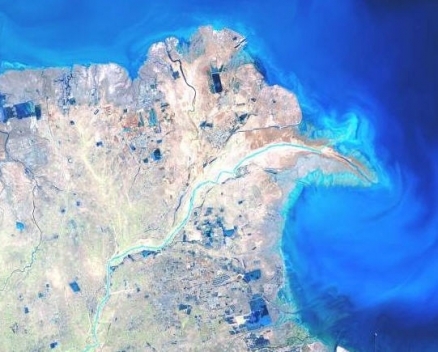
Satellite view of the saline meadow at the mouth of the Yellow River, China Photograph by USGS
This temperate coastal saline meadow encompasses the mouth of Luan He River and the Huang He Delta. The ecoregion functions as a critical refueling stop for migratory birds along the Siberian-Australasian flyway. Siltation is causing the meadow to gradually advance into the Bohai Sea. In recent years, rapid development in the Bohai-rim areas has brought serious damage to the local ecology. There are no protection measures in place to mitigate threats to species and habitats.
Location and General Description
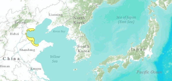
The Bohai Sea saline meadows occupy a crescent of the Chinese Coast located in the upper reaches of the Yellow Sea to the west of the Shandong Peninsula. Silt deposition from the Yellow River is building a delta in this area at a rate of two kilometers (km) per year. Grasslands inland from the intertidal zone are dominated by Imperata cylindrica, while saline meadows prone to flooding at high tide are dominated by goosefoot (Suaeda salsa). Grass and sedge marshes are an important component of the freshwater lakeside ecosystem further inland, but these have been almost completely extirpated by rice agriculture and fish aquaculture, as have the reed beds of Phragmites australis.
The Huang He (Yellow River) drains the extensive loess hill regions of north central China, transporting to the ocean vast quantities of unconsolidated glacial silt that were deposited during the Pleistocene. The Yellow River and the Yellow Sea, into which it flows, both derive their names from the color this silt load imparts. The result of these processes has been the formation of an extensive -- and rapidly growing -- delta at the mouth of the Yellow River (Bay of Bohai). Each year, 1.6 billion tons of sediment are transported downriver to increase the area of the delta by 50 km2 per year. Here, a gradient of saline meadows onshore and intertidal mudflat communities offshore provides habitat for many species, including populations of waterfowl and shorebirds.
Biodiversity Features
The delta region serves as a stopover for the red-crowned crane (Grus japonensis) and the Siberian crane (G. leucogeranus). The rare Saunders’ gull (Larus saundersi), listed as vulnerable by IUCN and BirdLife International, uses the Huang He Delta as one of its four global breeding sites. It is estimated that at least 800,000 waterbirds use the 4,800 km2 coastal wetland here, including at least 15 Red Data species. Though 1,500 km2 of coastal wetland has been declared a nature reserve, Dongying Huang He Sanjiaozhou, the area has already been severely disturbed.
More than 265 bird species have been recorded in this ecoregion, with a total number of more than 10 million. This includes seven species identified as Chinese first class of protection. There are an additional 40 species listed in The International Trade Treaty for Wild Animals and Plants which are in Imminent Danger.
Current Status
The northeastern part of the ecoregion supports a small area of saline meadow at Luan He estuary, east of the Municipality of Tianjin. This supports another breeding site for Saunders’ gull and passage for some migratory birds such as the relict gull (Larus relictus). Otherwise this section of coast has been largely converted to shrimp ponds and salt pans.
Types and Severity of Threats
Threats to the Dongying-Huang He Sanjiaozhou Nature Reserve include hunting (36,000 to 52,000 shorebirds are trapped annually); pollution from nearby oil fields; and reclamation for the rapid commercial and industrial development that is occurring here. Other threats include extensive marine aquaculture, particularly pond-rearing of shrimp.
The Ramsar Convention on Wetlands describes the threat of rising sea levels in this area: "The estimated relative sea level rise rate in the Yellow River Delta is 8 millimeters (mm) per year and the sea level rise will be 48 centimeters (cm) by the year 2050. This will lead to critical impacts such as the frequency of storm surges and El-Niño events to strengthen hydrodynamics, beach erosion, and landward retreat, wetland loss, saltwater intrusion, and land salinization."
Dongying-Huang He Nature Reserve houses the second largest oil field in China: Shengli Oilfield and oil industry is the primary industry of Dongying City. Others include chemical fertilizer manufacturing, textile, paper-making, cement manufacturing, salt chemical industry and food processing.
Justification of Ecoregion Delineation
This temperate coastal saline meadow covers at the mouth of Luan He River and the Huang He Delta which is gradually advancing into the Bohai sea due to siltation. The boundary corresponds to the CVMCC Vegetation Map of China class saline meadow. This is comparable to the North China Plain biogeographic subunit in the Oriental Deciduous Forests according to Mackinnon.
Additional information on this ecoregion
- For a shorter summary of this entry, see the WWF WildWorld profile of this ecoregion.
- To see the species that live in this ecoregion, including images and threat levels, see the WWF Wildfinder description of this ecoregion.
- World Wildlife Fund Homepage
Further Reading
- BirdLife International. 2000. Threatened birds of the world. Lynx Editions and BirdLife International, Barcelona and Cambridge, UK. ISBN: 0946888396
- Chinese Vegetation Map Compilation Committee (CVMCC). 1979. Vegetation map of China. Map (1:10,000,000). Science Press, Beijing. ISBN: 7030089561
- MacKinnon, J. and K. Phillipps. 2000. A field guide to the birds of China. Oxford University Press, New York. ISBN: 0198549407
- MacKinnon, J., M. Sha, C. Cheung, G. Carey, Z. Xiang, and D. Melville. 1996. A biodiversity review of China. Worldwide Fund for Nature (WWF) International, Hong Kong.
- Ramsar Convention on Wetlands. Retrieved (2000) from: www.ramsar.org
| Disclaimer: This article is taken wholly from, or contains information that was originally published by, the World Wildlife Fund. Topic editors and authors for the Encyclopedia of Earth may have edited its content or added new information. The use of information from the World Wildlife Fund should not be construed as support for or endorsement by that organization for any new information added by EoE personnel, or for any editing of the original content. |