Aruba
| Topics: |
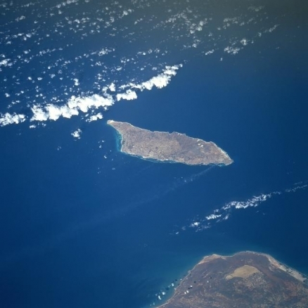
Image courtesy of NASA.
Countries and Regions of the World Collection  Aruba is a small, generally flat, riverless island in the southern Caribbean Sea, north of the coast of Venezuela. It is home to 106,000 people.
A constituent country of the Kingdom of the Netherlands with full autonomy in internal affairs, Aruba is part of the island group refered to as the Lesser Antillies and part of the region known as the Caribbean or the West Indies.

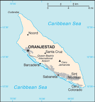 Aruba. Source: The CIA World Factbook Aruba. Source: The CIA World Factbook |
Aruba is a semi-arid island that experiences little variation in temperature throughout the year. Rainfall, which occurs mostly in November and December, averages less than 50 cm (20 in) a year. A flat, riverless island renowned for its white sand beaches; its tropical climate is moderated by constant trade winds from the Atlantic Ocean; the temperature is almost constant at about 27 degrees Celsius (81 degrees Fahrenheit).
The red soil on the island is poor and thin and the thorny vegetation is quite drought resistant.
Tourism and the refining of oil brought in from nearby Venezuela (whose northern coast appears below) are the major industries.
Oraniestad, located on the northwest coast, is the major city of the island.
Discovered and claimed for Spain in 1499, Aruba was acquired by the Dutch in 1636. The island's economy has been dominated by three main industries. A 19th century gold rush was followed by prosperity brought on by the opening in 1924 of an oil refinery. The last decades of the 20th century saw a boom in the tourism industry.
Aruba seceded from the Netherlands Antilles in 1986 and became a separate, autonomous member of the Kingdom of the Netherlands. Movement toward full independence was halted at Aruba's request in 1990.
Contents
Geography
Geographic Coordinates: 12 30 N, 69 58 W
Land Area: 193 square km.
arable land: 10.53%
permanent crops: 0%
other: 89.47% (2005)
Coastline: 68.5 km
Maritime Claims: territorial sea to 12 nautical miles.
Natural Hazards: Limited hurricane activity. Aruba lies outside the Caribbean hurricane belt and is rarely threatened.
Terrain: Flat with a few hills and scant vegetation. Its highest point is Mount Jamanota (188 meters)
Climate: Tropical marine with little seasonal temperature variation. Its tropical climate is moderated by constant trade winds from the Atlantic Ocean; the temperature is almost constant at about 27 degrees Celsius (81 degrees Fahrenheit)
Ecology and Biodiversity
See Aruba-Curaçao-Bonaire cactus scrub
 Aruba-Curaçao-Bonaire cactus scrub on Bonaire, Netherlands Antilles. (Source: Photograph by Michele Thieme)
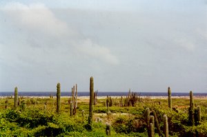
 Caribbean islands are often portrayed as lush tropical paradises, but Aruba shares the desert scrub known as the Aruba-Curaçao-Bonaire cactus scrub ecoregion with the islands of Curaçao and Bonaire ((sometimes called collectively "the A-B-C’s") . This dry desert scrub ecoregion receives little rainfall. A haven for avifauna, over two hundred bird species are found here, many of which are endangered. Tourism is a major threat to this habitat as development for. Also, feral goats and sheep destroy much of the natural vegetation through grazing. Columnar cacti are common, and can grow up to six meters tall. The dominant cacti species are: Stenocereus griseus, Subpilocereus repandus, and Pilosocereus lanuginosus. These species flower and fruit profusely during the dry season, and provide critical resources for a variety of bats, birds and other animals.
Coral reefs are an important marine resource; the chief sources of reef threat and degradation in Aruba are overfishing and marine water pollution, not sea temperature change. (Burke & Maidens, 2004)
There are very few endemic plant species on the islands: only two on Aruba. Nevertheless, the floral community has a distinct character. The xerophytic community of the ABC’s may not have the diversity of a tropical rainforest, but it does boast a unique fauna, with its own radiation’s. The most important components of this community are the cacti- they dominate the landscape and provide critical food resources for nectarivores and frugivores.
The Arikok National Park covers 17% of Aruba. A Coastal Protection Zone extending 1 km inland has been designated to preserve the entire northern and eastern sides of the island. On Aruba, the serious decline of at least 11 of the 48 native tree species has led to efforts to restore natural areas through out-planting and goat control. Private organizations such as the Save the Lora Association are also working to protect endangered species on the islands.
|
|
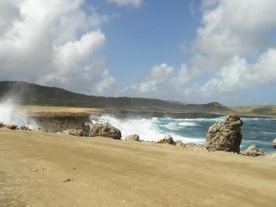
| East shore near Budi. |
|
|
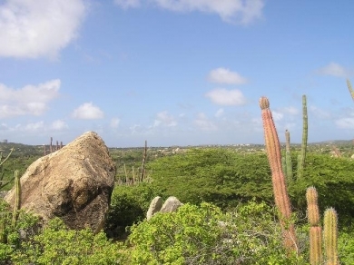
| Desert vegetation at Arikok National Park. The park extends over about 18% of the island. |
|
|
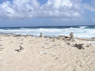
| Rock figurines on a beach along the east shore. |
|
|
| Arikok National Park. Source: Wikimedia Commons. |

People and Society
Population: 107,635 (July 2012 est.) Note: estimate based on a revision of the base population, fertility, and mortality numbers, as well as a revision of 1985-99 migration estimates from outmigration to inmigration, which is assumed to continue into the future; the new results are consistent with the 2000 census
Ethnis groups: mixed white/Caribbean Amerindian 80%, other 20%
Age Structure:
0-14 years: 18.4% (male 9,847/female 9,729)
15-64 years: 70.3% (male 35,809/female 38,816)
65 years and over: 11.2% (male 4,698/female 7,214) (2011 est.)
Population Growth Rate: 1.413% (2012 est.)
Birthrate: 12.76 births/1,000 population (2012 est.)
Death Rate: 7.92 deaths/1,000 population (July 2012 est.)
Net Migration Rate: 9.29 migrant(s)/1,000 population (2012 est.)
Life Expectancy at Birth: 75.93 years
male: 72.89 years
female: 79.04 years (2012 est.)
Total Fertility Rate: 1.84 children born/woman (2012 est.)
Languages: Papiamento (a Spanish-Portuguese-Dutch-English dialect) 66.3%, Spanish 12.6%, English (widely spoken) 7.7%, Dutch (official) 5.8%, other 2.2%, unspecified or unknown 5.3% (2000 census)
Literacy: 97.3% (2000 census)
Urbanization: 47% of total population (2010) growing at an annual rate of change of 0.6% (2010-15 est.)
History
Aruba's first inhabitants were the Caquetios Indians from the Arawak tribe. Fragments of the earliest known Indian settlements date back to about 1000 A.D. Spanish explorer Alonso de Ojeda is regarded as the first European to arrive in about 1499. The Spanish garrison on Aruba dwindled following the Dutch capture of nearby Bonaire and Curacao in 1634. The Dutch occupied Aruba shortly thereafter, and retained control for nearly two centuries.
In 1805, during the Napoleonic wars, the English briefly took control over the island, but it was returned to Dutch control in 1816. A 19th-century gold rush was followed by prosperity brought on by the opening in 1924 of an oil refinery. The last decades of the 20th century saw a boom in the tourism industry.
In 1986 Aruba seceded from the Netherlands Antilles and became a separate, autonomous member of the Kingdom of the Netherlands. Movement toward full independence was halted at Aruba's prerogative in 1990.
Aruba has a mixture of people from South America and Europe, the Far East, and other islands of the Caribbean.
Government
Part of the Kingdom of the Netherlands, Aruba has semi-autonomy on most internal affairs with the exception of defense, foreign affairs, final judicial review, and "Kingdom matters" including human rights and good governance. The constitution was enacted in January 1986. Executive power rests with a governor, while a prime minister heads an eight-member Cabinet. The governor is appointed for a 6-year term by the monarch and the prime minister and deputy prime minister are elected by the legislature, or Staten, for 4-year terms. The Staten is made up of 21 members elected by direct, popular vote to serve 4-year terms. Aruba's judicial system, mainly derived from the Dutch system, operates independently of the legislature and the executive. Jurisdiction, including appeal, lies with the Common Court of Justice of Aruba and the Kingdom-level Supreme Court of Justice in the Netherlands.
Dependency Status: constituent country of the Kingdom of the Netherlands; full autonomy in internal affairs obtained in 1986 upon separation from the Netherlands Antilles; Dutch Government responsible for defense and foreign affairs
Government Type: Parliamentary democracy
Capital: Oranjestad - 33,000 (2009)
Legal system: civil law system based on the Dutch civil code
Agriculture
Agricultural products: Aloes; livestock; fish
Irrigated Land: 0.01 sq km (1998 est.)
Economy
Through the 1990s and into the 21st century Aruba posted growth rates around 5%. However, in 2001, a decrease in demand and the terrorist attacks on the United States led to the first economic contraction in 15 years. Deficit spending has been a staple in Aruba's history, and modestly high inflation has been present as well, although recent efforts at tightening monetary policy may correct this. The sizes of the agriculture and manufacturing industries remain minimal.
Tourism is the mainstay of the small open Aruban economy, together with offshore banking. Oil refining and storage ended in 2009.
The rapid growth of the tourism sector over the last decade has resulted in a substantial expansion of other activities. Over 1.5 million tourists per year visit Aruba with 75% of those from the US.
Construction continues to boom with hotel capacity five times the 1985 level.
Tourist arrivals rebounded strongly following a dip after the 11 September 2001 attacks.
The government has made cutting the budget and trade deficits a high priority.
GDP: (Purchasing Power Parity): $2.258 billion (2005 est.)
GDP: (Official Exchange Rate): $2.258 billion (2005 est.)
GDP- per capita (PPP): $21,800 (2004 est.)
GDP- composition by sector:
agriculture: 0.4%
industry: 33.3%
services: 66.3% (2002 est.)
Industries: Tourism, transshipment facilities, oil refining.
Currency: Aruban guilders/florins
References
- Burke, L. and J. Maidens , 2004 , Reefs at Risk in the Caribbean. . World Resources Institute, Washington. 81 p