Arnhem Land tropical savanna
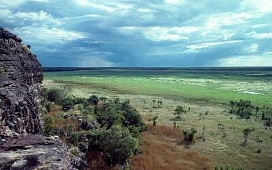
Kakadu National Park, Northern Territory Photograph by © WWF-Canon/James W. Thorsell
The rugged sandstone massif of Arnhem Land extends over a relatively flat landscape along the northern coast of Australia.Here, rivers make their way down to the coast, creating vast floodplains during the annual monsoon rains. Open eucalypt forests extend across most of the landscape, intermixed with small patches of rainforest, and notable communities of heath vegetation grow on the sandstone escarpment. The sandstone massif harbors a highly endemic biota, including vascular plants and mammals. The vast wetlands of this region are extremely productive and known for their high rodent and snake densities. Vast portions of this ecoregion remain in their natural state, preserving large-scale natural processes such as bird migration. This ecosystem is well preserved in protected areas, including the iconic Kakadu National Park, but changes in the fire regime, feral animals, and weeds are all threats.
Location and General Description

This region is strongly influenced by a markedly seasonal, monsoonal climate, with a short wet season from November to March, and then a long, nearly rain-free period for the rest of the year. This region has the highest rainfall in northwestern Australia, extending from an annual total of 1200 millimeters (mm) in the south to 1800 mm on the Tiwi Islands in the north. Temperatures are high throughout the year and monthly average maxima range from 27° to 33°C.
The rugged sandstone massif of western Arnhem Land is the major topographic feature in an otherwise largely subdued landscape. The region includes three of Australia's six largest islands (Bathurst and Melville Islands, and Groote Eylandt) and many smaller islands. It includes the entire catchment of some large rivers, notably the South and East Alligator Rivers, the Mary River, and the Glyde River. As they flow down to the coast, the lower reaches of these rivers become highly sinuous and cross extensive, low-relief plains. These plains form vast swamplands during the annual wet season floods.

Eucalypt open forests extend across most of the landscape, typically dominated by Darwin stringybark (Eucalyptus tetrodonta) and Darwin woollybutt (E. miniata) growing up to 20 meters (m) tall. A tall grass understory of 2.5 m is below, normally consisting of Sorghum spp. However, more than 10,000 rainforest or "monsoon vine-thicket" patches are found within this dominant matrix. Other notable vegetation features include extensive mangrove forests, floodplain sedgelands and grasslands, swamp forests dominated by Melaleuca species, and heathlands in the sandstone plateau and sandsheets.
The environments and biota of this region grade into the three regions to the immediate south (Carpentaria, Kimberly, and Victoria Plains tropical savanna [[ecoregion]s]), as steadily decreasing rainfall leads to the gradual replacement of dominant eucalypt forests by eucalypt savanna woodlands, with lower canopy cover and height. The incidence of monsoon rainforest patches decreases markedly with the transition south. This region also shares many environments and species with the Cape York tropical savanna ecoregion, reflecting their generally similar rainfall patterns, geology and soils, and a former land bridge between the two regions.
Biodiversity Features
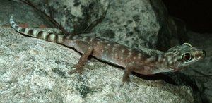 Giant cave gecko (Pseudothecadactylus lindneri), Northern Territory, Australia. (Source: Photograph by Alexander Dudley)
 Much of the present-day ecology of the region is influenced by its past, with rapid climatic oscillation over the last 20,000 years winnowing much of the region's biota. Until 10,000 to 20,000 years ago, almost all of the islands in this region were connected to the mainland, and there was a land bridge connecting this region, the Cape York Peninsula, and New Guinea. The distinctive floodplains of this ecoregion are an even more recent feature, with most being formed only in the last 5,000 years.
The most outstanding biological feature of this region is the endemism associated with the highly dissected sandstone plateau of western Arnhem Land. The topographic variation and associated microclimates provided amelioration and refuge during times of rapid climatic oscillation. The ruggedness of this massif has also promoted extraordinarily high levels of speciation in some species with poor dispersal power, such as the trigger plants Stylidium. Many of the endemic species have highly localized ranges, but one tall endemic tree Allosyncarpia ternata (Myrtaceae) is dominant over large areas and can form monospecific stands of tall closed forests.
The sandstone massif of western Arnhem Land harbors a highly endemic biota, with endemism seen across many animal and plant groups. Approximately 50 vascular plant species, many terrestrial and aquatic invertebrates, fish, and frogs are endemic. A number of reptiles are endemic, including the massive Oenpelli python (Morelia oenpelliensis), as are a number of birds, e.g. the black-banded fruit-dove (Ptilonopus alligator), chestnut-quilled rock-pigeon (Petrophassa rufipennis), and white-throated grass-wren (Amytornis woodwardi). Endemic mammals native to the sandstone massif include the Arnhem Land rock-rat (Zyzomys maini) and the black wallaroo (Macropus bernardus).
There is also some endemism associated with the larger islands of this region, although their relatively recent isolation means that most endemism is at the subspecific level. The patches of monsoon rainforest also support some endemic taxa, including 36 plant species from a total reported flora of 585 species. But the relatively small size of most rainforest patches (median size less than 5 hectares [ha]), and the small total extent of this environment (ca 2500 square-kilometers [km2]) has probably precluded vertebrate endemism.
The invertebrates of this region are generally poorly known, but a number of studies of the ant fauna have suggested that it is one of the richest in the world, with more than 100 species reported from sites of only 500 m2. Even among the comparatively well-studied ants, only about one-quarter of the species in this ecoregion have been described. Many newly described plant species are being added each year: the number of plant species recorded from the relatively well-known Kakadu National Park area has increased from 954 in 1973, to 1346 in 1986, 1531 in 1988, 1682 in 1990, 1787 in 1992 and 1899 in 1996. New vertebrate species are still being discovered in this ecoregion, such as the recently described burrowing snake Simoselaps morrisi, the Kakadu dunnart (Sminthopsis bindi), and the Kakadu pebble-mound mouse (Pseudomys calabyi), indicating that other species may remain to be discovered.
Many of the wetlands in this region are highly productive and are recognized as internationally significant. They support the world's largest breeding colonies of magpie geese (Anseranas semipalmata), with up to 50,000 nests and 500,000 individual birds in some [[swamp]s]. They also support many other waterfowl, and extraordinarily high densities of a specialized rodent, the dusky rat (Rattus colletti), and its predator the water python (Liasis fuscus). Densities of dusky rats may reach up to 150 individuals/ha or 1 tonne/km2, while water python densities may approach 700 individuals per km2. There are high densities of many other species including barramundi (Lates calcarifer), freshwater turtle species, freshwater crocodile (Crocodylus johnstoni), saltwater crocodile (C. porosus), and the arafura file snake (Acrochordus arafurae), which may approach densities up to 400 individuals/ha in remnant billabongs during the dry season. The region's [[coast]line] is also internationally significant due to the large number and size of seabird colonies and its relatively undisturbed marine turtle breeding sites.
Much of the region's conservation value is not site-specific, but rather is due to the vast areas maintained in "natural" condition, allowing the uninterrupted working of landscape-scale ecological processes. Forced, or stimulated, by the marked seasonal variability in resources, many animals make broad-scale movements within the region; and the region also attracts some bird species which escape the relatively cold, wet winters of southern Australia. The environmental intactness of this region has allowed the persistence of some animal species that have declined or become regionally extinct elsewhere in Australia. This refugial function may become more pronounced in the future, and may imbue the region's islands with substantial conservation significance.
Current Status
 Kakadu National Park, Northern Territory, Australia. (Source: Photograph by © WWF-Canon/James W. Thorsell)
 Aboriginal Land Trusts hold most of this region as inalienable tenure, and many parts of the ecoregion are managed in ways reflecting the more than 40,000 years of continuous occupation by these peoples. Aboriginal lands include the nearly 20,000 km2 Kakadu National Park, one of Australia's largest and most iconic national parks, also recognized as a World Heritage site for its outstanding natural and cultural values.
The environments of this region are largely unaffected by broad-scale clearing and major habitat modification, with several exceptions. Most notably, land has been cleared for horticultural production in the vicinity of Darwin, some relatively minor clearing has occurred for strip mining in north-eastern Arnhem Land and Groote Eylandt, and there is some plantation forestry of exotic tree species on Melville Island. Conservation reserves comprise 26,662 km2 or 17 percent of the region, and include good representation of the full range of environments found here.
In contrast to most other regions in Australia, the Arnhem Land tropical savanna has suffered no known extinctions in the 200 years since European colonization. However, there is recent evidence of substantial declines in at least some bird and mammal assemblages. Endangered species present include the palm (Ptychosperma macarthuri - listed as CR under former name P. bleeseri), the gouldian finch (Erythrura gouldiae EN), and the golden bandicoot (Isoodon auratus VU). One hundred years ago, the golden bandicoot's distribution extended across almost all of the Northern Territory, but it now occurs on only one island. Sandstone heathland has recently been nominated for listing as an endangered community.
Types and Severity of Threats
The main threats to this region are pervasive and insidious, rather than localized and acute. Over large areas, fire regimes have changed markedly over the last century, with increased incidence of destructive late dry season fires, in contrast to the intricate cooler burning regimes thought to have been used under traditional Aboriginal management. Approximately half of the region is burnt every year. The current regime is leading to degradation of the fire-sensitive elements within the landscape, most notably monsoon rainforest patches, and sandstone heathland plants which reproduce through seed and largely require a fire-free interval of at least 4 to 5 years. The altered fire regime is also leading to structural and floristic change within the otherwise fairly resilient eucalypt forests, and such vegetation change is affecting a range of animal species.
Many plant species have been introduced to the region for pastoral and ornamental use. Some of these have proven to be extraordinarily invasive and have radically altered environments and ecosystem processes. These weeds include the giant sensitive plant (Mimosa pigra), which has transformed more than 10,000 km2 of floodplain grasslands into woody monocultures, and continues to spread rapidly across wetlands. Mission grass (Pennisetum polystachion) and gamba grass (Andropogon gayanus) have invaded the eucalypt open forests across vast areas, greatly increasing fuel loads and leading to more destructive fires. Para grass (Brachiaria mutica), olive hymenachne (Hymenachne amplexicaulis), and salvinia (Salvinia molesta) have transformed wetlands to the detriment of many native species, notably including magpie geese. While some of these weed species are currently partially controlled by management actions, it is highly likely that most will continue to spread and transform the environments over increasingly large areas.
The exotic red fox (Vulpes vulpes) is absent from northern Australia, in contrast to most of the rest of the Australian mainland, where it has ravaged the native mammal fauna. However, feral cats are widespread and may be implicated in the recent decline of some native mammal assemblages. Feral water buffalo (Bubalus bubalis), cattle (Bos taurus, B. indicus), and pigs (Sus scrofa) are widespread in the region, and responsible for substantial environmental degradation. There are also smaller and more localized populations of feral banteng (B. javanicus), goats (Capra hircus), and sambar deer (Cervus unicolor). The cane toad (Bufo marinus) invaded the region in 2000 and has spread rapidly and in large numbers, possibly to the detriment of many carnivorous mammals, reptiles and fish. The big-headed ant (Pheidole megacephala) has also invaded over the last decade, reducing the local diversity (Species diversity) of native invertebrate assemblages.
Because of their low elevation, the distinctive and highly productive floodplain environments are threatened by minor rises in sea level associated with global climate change. Over 240 km2 of floodplains have been destroyed by saltwater intrusion over the last 50 years, and the problem is likely to be exacerbated with increasing rates of climate change.
Justification of Ecoregion Delineation
The Arnhem Land tropical savanna ecoregion includes the four Interim Biogeographic Regions of Australia (IBRAs): 'Top End Coastal', 'Daly Basin', 'Central Arnhem', and 'Pine-Creek Arnhem'. This ecoregion encompasses the 'Kakadu-Alligator Rivers Region' Centre of Plant Diversity and is part of the 'North-west Australia' Endemic Bird Area.
Additional information on this ecoregion
- For a shorter summary of this entry, see the WWF WildWorld profile of this ecoregion.
- To see the species that live in this ecoregion, including images and threat levels, see the WWF Wildfinder description of this ecoregion.
- World Wildlife Fund Homepage
Further Reading
- Andersen, A.N. 1991. Sampling communities of ground-foraging ants: pitfall catches compared with quadrat counts in an Australian tropical savanna. Australian Journal of Ecology, 16:273-279.
- Andersen, A.N. 2001. The Ants of Northern Australia: A Guide to the Monsoonal Fauna. CSIRO Publishing, Collingwood, Australia. ISBN: 0643066039
- Bowman, D.M.J.S. and W.J. Panton. 1993. Decline of Callitris intratropica R.T. Baker & H.G. Smith in the Northern Territory: implications for pre- and post-European colonization fire regimes. Journal of Biogeography, 20:373-381.
- Bowman, D.M. J.S., B.A. Wilson, and R.J. Hooper. 1988. Response of Eucalyptus forest and woodland to four fire regimes at Munmarlary, Northern Territory, Australia. Journal of Ecology, 76:215-232.
- Brennan, K. 1996. An annotated checklist of the vascular plants of the Alligator Rivers Region, Northern Territory, Australia. Report 109. Supervising Scientist, Canberra, Australia.
- Carlquist, S. 1979. Stylidium in Arnhem Land: new species modes of speciation on the sandstone plateau, and comments on floral mimicry. Aliso. 9:461-551.
- Chatto, R., and P. Whitehead. 1996. Northern Territory. Pages 119 – 176. A directory of important wetlands in Australia. Australian Nature Conservation Agency, Canberra, Australia.
- Franklin, D.C. 1999. Evidence of disarray amongst granivorous bird assemblages in the savannas of northern Australia, a region of sparse human settlement. Biological Conservation, 90:53-68.
- Hilton-Taylor, C. 2000. The IUCN 2000 Red List of Threatened Species. IUCN, Gland, Switzerland and Cambridge, United Kingdom. ISBN: 2831705657
- Houston, D., and R. Shine. 1994. Population demography of Arafura filesnakes (Serpentes: Acrochordidae) in tropical Australia. Journal of Herpetology, 28:273-280.
- Ingwersen, F. 1995. Kakadu-Alligator Rivers Region, Northern Territory, Australia - CPD Site Au4. Pages 471-475 in S. D. Davis, V. H. Heywood and A. C. Hamilton. editors. Centres of Plant Diversity. Volume 2. Asia, Australasia, and the Pacific. WWF/IUCN, IUCN Publications Unit, Cambridge, UK. ISBN: 2831701988
- Liddle, D.T., J. Russell-Smith, J. Brock, G.J. Leach, and G.T. Connors. 1994. Atlas of the vascular rainforest plants of the Northern Territory. Flora of Australia Supplementary Series no. 3. Australian Biological Resources Study, Canberra, Australia. ISBN: 0642203180
- Madsen, T., and R. Shine. 1996. Seasonal migration of predators and prey - a study of pythons and rats in tropical Australia. Ecology, 77:149-156.
- Nix, H.A., and J.D. Kalma. 1972. Climate as a Dominant Control in the Biogeography of Borthern Australia and New Guinea. Pages 61-91 in D. Walker, editor. Bridge and Barrier: A Natural and Cultural History of Torres Strait. ANU Press, Canberra, Australia. ISBN: 0708108202
- Northern Territory Government. 1998. Mary River Integrated Management Plan. Northern Territory Government, Darwin, Australia.
- Palmer, C., and J. C. Z. Woinarski. 1999. Seasonal roosts and foraging movements of the black flying fox Pteropus alecto in the Northern Territory: resource tracking in a landscape mosaic. Wildlife Research, 26:823-838.
- Press, T., D. Lea, A. Webb, and A. Graham, editors. 1995. Kakadu: Natural and Cultural Heritage and Management. Australian Nature Conservation Agency and North Australia Research Unit, Darwin, Australia. ISBN: 0731521714
- Price, O., J.C.Z. Woinarski, D.L. Liddle, and J. Russell-Smith. 1995. Patterns of species composition and reserve design for a fragmented estate: monsoon rainforests in the Northern Territory, Australia. Biological Conservation, 74:9-19.
- Price, O.F., J.C.Z. Woinarski, and D. Robinson. 1999. Very large area requirements for frugivorous birds in monsoon rainforests of the Northern Territory, Australia. Biological Conservation, 91:169-180.
- Russell-Smith, J., and D. M. J. S. Bowman. 1992. Conservation of monsoon rainforest isolates in the Northern Territory, Australia. Biological Conservation, 59:51-63.
- Russell-Smith, J., N.L. McKenzie, and J.C.Z. Woinarski. 1992. Conserving vulnerable habitat in northern and northwestern Australia: the rainforest archipelago. Pages 63–68 in I. Moffatt and A. Webb, editors. Conservation and Development Issues in Northern Australia. North Australia Research Unit, Darwin, Australia. ISBN: 0731514289
- Russell-Smith, J., D.E. Lucas, J. Brock, and D.M.J.S. Bowman. 1993. Allosyncarpia-dominated rain forest in monsoonal northern Australia. Journal of Vegetation Science, 4:67-82.
- Russell-Smith, J., P.G. Ryan, D. Klessa, G. Waight, and R. Harwood. 1998. Fire regimes, fire-sensitive vegetation and fire management of the sandstone Arnhem plateau, monsoonal northern Australia. Journal of Applied Ecology, 35:829-846.
- Southgate, R., C. Palmer, M. Adams, P. Masters, B. Triggs, and J. Woinarski. 1996. Population and habitat characteristics of the Golden Bandicoot (Isoodon auratus) on Marchinbar Island, Northern Territory. Wildlife Research, 23:647-664.
- Stattersfield, A.J., M.J. Crosby, A.J. Long, and D.C. Wedge. 1998. Endemic Bird Areas of the World: Priorities for Biodiversity Conservation. BirdLife Conservation Series No. 7. BirdLife International, Cambridge, United Kingdom. ISBN: 1560985747
- Thackway, R. and I.D. Cresswell, editors. 1995. An Interim Biogeographic Regionalisation for Australia: a framework for establishing the national system of reserves, Version 4.0. Australian Nature Conservation Agency, Canberra.
- Woinarski, J.C.Z, and R.W. Braithwaite. 1990. Conservation foci for Australian birds and mammals. Search, 21:65-69.
- Woinarski, J., K. Brennan, C. Hempel, R. Firth, and F. Watt. 2000a. Biodiversity conservation on the Tiwi Islands: plants, vegetation types and terrestrial vertebrates on Melville Island. Report to the Tiwi Land Council. Parks and Wildlife Commission of the Northern Territory, Darwin, Australia.
- Woinarski, J.C.Z., D. Franklin, and G. Connors. 2000b. Thinking honeyeater: nectar maps for the Northern Territory, Australia, showing spatial and temporal variation in nectar availability. Pacific Conservation Biology, 6:61-80.
- Woinarski, J.C.Z., D.J. Milne, and G. Wanganeen. 2001. Changes in mammal populations in relatively intact landscapes of Kakadu National Park, Northern Territory, Australia. Austral Ecology, 26:360-370.
- Woodroffe, C.D., and M.E. Mulrennan. 1993. Geomorphology of the Lower Mary River Plains, Northern Territory. Australian National University North Australian Research Unit and Conservation Commission of the Northern Territory, Darwin, Australia.
| Disclaimer: This article is taken wholly from, or contains information that was originally published by, the World Wildlife Fund. Topic editors and authors for the Encyclopedia of Earth may have edited its content or added new information. The use of information from the World Wildlife Fund should not be construed as support for or endorsement by that organization for any new information added by EoE personnel, or for any editing of the original content. |