Antarctic Coast
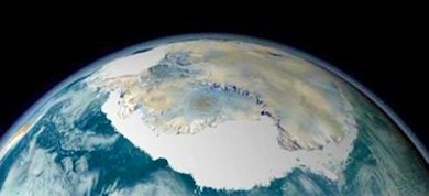
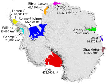
The Antarctic Coast circumscribes the continent of Antarctica and is 17,968 kilometers in length. The entire coastline is encased in ice for much of the year as shown in the satellite image to the right. Some parts of the Antarctic coast is permanently locked behind one of the many Antarctic Ice Shelves, some of which are shown in the diagram to the right; there are a total of 47 named Antarctic Ice Shelves.
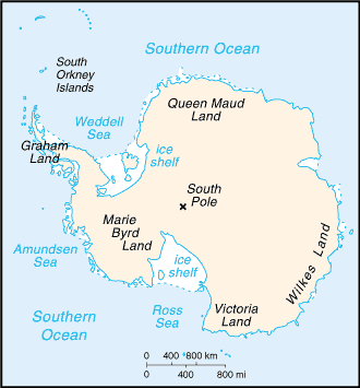
The following lists the coastal areas moving west from the northern tip of the Antarctic Peninsula around the entire continent back to the tip of the Peninsula. The coastal stretches are grouped under the general names of the interior regions of Antarctica. Where the coast runs predominantly east to west the longitude of its start and finish are given. Finally, selected points of interest are added pursuant to the following format:
- Interior region
- Coastal stretch
- Points of interest
- Coastal stretch
Contents
Antarctic Peninsula (west side from north to south)
- Graham Land
- Trinity Peninsula
- Davis Coast
- Danco Coast
- Hughes Bay (sight of first landing on the mainland)
- Graham Coast
- Loubet Coast
- Fallières Coast
- Palmer Land
- Rymill Coast (Alexander Island and Charcot Island lie west of this coast)
- Western part of Ellsworth Land (72oW - 103 oW )
- English Coast (67oW - 80oW )
- Bryan Coast (80oW - 90oW )
- Eights Coast (90oW - 103 oW )
- Marie Byrd Land (103oW - 155oW )
- Walgreen Coast (103oW - 114oW )
- Bakutis Coast (114oW - 127oW )
- Hobbs Coast (127oW - 137oW )
- Ruppert Coast (137oW - 146oW )
- Saunders Coast (146oW - 158oW )
- Edward VII Peninsula (155oW)
Behind the Ross Ice Shelf/Great Ice Barrier (155 oW - 164oE )
- Shirase Coast
- Siple Coast
- Gould Coast
- Amundsen Coast
- Bay of Whales (164oW)
- Dufek Coast
- Shackleton Coast
- Ross Island (168oE)
- Hillary Coast
- McMurdo Sound (168o E - 164 oE)
- Victoria Land (164oE - 142oE)
- Scott Coast
- McMurdo Dry Valleys (162o E)
- Borchgrevink Coast
- Cape Adare (170o E)
- Pennell Coast (170oE - 164oE)
- Oates Coast (164oE - 154oE)
- George V Coast (154oE - 142oE)
- Scott Coast
- Wilkes Land (142oE - 100oE)
- Adélie Coast (142oE - 136oE)
- Clarie Coast (136oE - 130oE)
- Banzare Coast (130oE - 122oE)
- Sabrina Coast (122oE - 116oE)
- Budd Coast (116oE - 109oE)
- Knox Coast (109oE - 100oE)
- Queen Mary Coast (100oE - 92oE)
- Wilhelm II Coast (92oE - 88oE)
- Leopold and Astrid Coast (88oE - 81oE)
- American Highland
- Ingrid Christensen Coast (81oE - 73oE)
- MacRobertson Land (70oE - 60oE)
- Lars Christensen Coast (71oE - 67oE)
- Mawson Coast (67oE - 60oE)
- Enderby Land (60oE - 45oE)
- Kemp Coast (60oE - 45oE)
- Cape Ann (41oE)
- Kemp Coast (60oE - 45oE)
- Queen Maud Land (45oE - 20oW)
- Prince Olav Coast (45oE - 40oE)
- Prince Harald Coast (40oE - 34oE)
- Princess Ragnhild Coast (34oE - 20oE)
- Princess Astrid Coast (20oE - 5oE)
- Princess Martha Coast (5oE - 20oW)
- Coats Land (20oW - 36oW)
- Caird Coast (20oW - 28oW)
- Luitpold Coast (28oW - 36oW)
- Behind the Ronne Ice Shelf
- Zumberge Coast (70oW - 78oW)
- Orville Coast (62oW - 70oW)
Antarctic Peninsula (east side from south to north)
- Lassiter Coast
- Black Coast
- Wilkins Coast
- Bowman Coast
- Foyn Coast
- Oscar II Coast
- Nordenskjöld Coast