Antarctic Bottom Water
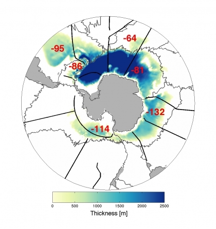
A layer of Antarctic Bottom Water colder than 0ºC (colors, with darkest blue areas having the thickest layer, and white none) covers the ocean floor around Antarctica. Source: NOAA.
Antarctic Bottom Water (AABW) is a type of water in the seas surrounding Antarctica with temperatures ranging from 0 to -0.8oC, salinities from 34.6 to 34.7, and a density near 27.88. ABW is formed in the Weddell Sea and Ross Sea. This is the densest water in the free ocean, with the only denser waters being found in regional sill basins such as the Norwegian Sea or the Mediterranean Sea. It is overlain by Antarctic Circumpolar Water (AACW) at a depth of 1000 to 2000 m M (Tchernia) and overlies Weddell Sea Bottom Water (WSBW) in some locations.
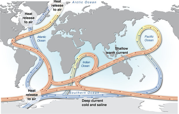 World ocean thermohaline circulation. The global conveyor belt thermohaline circulation is driven primarily by the formation and sinking of deep water (from around 1500m to the Antarctic bottom water overlying the bottom of the ocean) in the Norwegian Sea. When the strength of the haline forcing increases due to excess precipitation, runoff, or ice melt the conveyor belt will weaken or even shut down. The variability in the strength of the conveyor belt will lead to climate change in Europe and it could also influence in other areas of the global ocean. Source: Hugo Ahlenius, UNEP/GRID-Arendal
 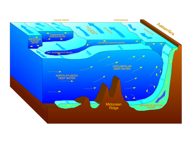 Water mass bodies of the Southern Ocean. Source: Hannes Grobe, Alfred Wegener Institute for Polar and Marine Research, Bremerhaven, Germany
 The flow of AABW in the tropical Atlantic is described by Rhein et al. [1998] as:
About one-third of the northward flowing AABW at 10oS (4.8 Sv) and at 5oS (4.7 Sv) west of about 31o30’W enters the Guiana Basin, mainly through the southern half of the Equatorial Channel at 35oW (1.5–1.8 Sv). The other part recirculates and some of it flows through the Romanche Fracture Zone into the eastern Atlantic. In the Guiana Basin, west of 40oW, the sloping topography and the strong, eastward flowing deep western boundary current might prevent the AABW from flowing west: thus it has to turn north at the eastern slope of the Ceara Rise (2.2 Sv). At 44oW, north of the Ceara Rise, AABW flows west in the interior of the basin in a main core near 7o15’N (1.9 Sv). A net return flow of about 0.5 Sv was found north of 8o43’N. A large fraction of the AABW (1.1 Sv) enters the eastern Atlantic through the Vema Fracture Zone, leaving only 0.3 Sv of AABW for the western Atlantic basins.
See Also
Further Reading
- Peter Saundry. 2011. Seas of the world. topic ed. C.Michael Hogan. Ed.-in-chief Cutler J.cleveland. Encyclopedia of Earth
- S. S. Jacobs, A. F. Amos, and P. M. Bruckhausen. Ross Sea oceanography and Antarctic Bottom Water formation. Deep-Sea Res., 17:935–962, 1970.
- Matthias Tomczak and J. Stuart Godfrey. Regional Oceanography: An Introduction. Pergamon, 1994.
- P. Tchernia. Descriptive Regional Oceanography: An Elementary Description of the Four Main Divisions of the World Ocean, of their Limits, Forms, Topography, Wind Systems, Climatology, Surface Circulation, and Hydrological Characteristics and Structure. Pergamon Press, 1980.
- Monika Rhein, Lothar Stramma, and Gerd Krahmann. The spreading of Antarctic bottom water in the tropical Atlantic. DSR, 45:507–527, 1998.