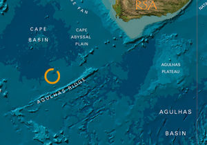
Agulhas Basin

The Agulhas Basin is an ocean basin located off the southern tip of Africa at about 43 degrees S in the South Atlantic Ocean. The basin includes the Agulhas Abyssal Plain. The basin's marine ecosystem manifests great biodiversity and endemism with its fringing mangroves and coastal shelf seagrass beds. The chief flux feature of the basin is the Agulhas Current, a swift moving jet that sweeps downward along the southeast part of the African continent.
Contents
Agulas Current
The Agulhas Current is a robust western boundary jet in the Indian Ocean south of 30oS. The southern Agulhas Current flows southwestward as a narrow jet along a steep continental slope, and is normally pinned to within 10 to 15 kilometres (km) of its mean position at latitudes 28.5–30.0 degrees South. The current generally effluxes from the southern part of the Mozambique Channel.
Large meanders, called the Natal Pulse, sometimes occur within this region. These meanders extend an average of 170 km offshore with downstream propagation rates of about 21 centimeters/second (cm/s), with the rates decreasing to five cm/s as the continental shelf broadens near 34 degrees South. At this point the current separates from the coast and continues southwestward along the Agulhas Bank, where many meanders, plumes and eddies exist.
The maximum transport of the Agulhas occurs in the vicinity of Agulhas Bank, where transport estimates range from 95 to 136 Sverdrup. The core of the current has been defined as where surface velocities exceed 100 cm/s with the core averaging about 34 km wide with a mean peak speed of 136 cm/s (with a greatest peak speed of 245 cm/s).
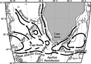
At around 36oS the Agulhas leaves the continental shelf and develops oscillations of increasing amplitude, eventually retroflecting back toward the Indian Ocean in the region of 16 to 20 degrees East as the Agulhas Return Current. The retroflection loop usually encloses a pool of Indian Ocean surface water south of Africa whose temperature is more than five degrees Celsium warmer than South Atlantic surface water at similar latitudes. The core of the Return Current infrequently passes over the Agulhas Plateau.
Agulhas Front
The Agulhas Front is a strong oceanic water front that occurs from subsurface to intermediate depth beneath the upper 100–150 m that originates at around 20 to 25 degrees E below the southern tip of Africa. It extends to between 65 to 90 degrees E where it merges with the Southern Subtropical Front in the Indian Ocean sector of the Antarctic Circumpolar Current. The chief identification criterion is usually the depth range of the ten degree Celsius isotherm, about 300–800 m south of Africa at 16 to27 degrees E. This range shrinks to about 400–650 m to the east in the Kerguelan–Amsterdam passage, indicating the gradual weakening of the Agulhas Front. A thermostad on the warm side of the AF in the 150–300 m layer is another useful identification criterion. This thermostad cools and freshens to the east.
Marine Ecosystem
The Agulas Basin mangroves, seagrass beds, and coral reefs reflect high degrees of biodiversity and endemism (e.g. the Zanzibar butterfly fish, the African butterfly fish, the ear-spot angelfish, and the tail-barred parrotfish). South Africa’s De Hoop Nature Reserve is important to several species of dolphins and the southern right whale. South Africa has several species of sea turtles, porpoises, jackass (black-footed) penguins, great white sharks, and abalone. The Agulhas Current LME is considered a Class II, moderately productive (150-300 grams of Carbon per square meter per year (gC/m2-yr)), ecosystem . Nutrient enrichment and mixing is current-associated within the Agulhas Current. Several studies have suggested that the Agulhas Basin's current disperses the early life history stages of various fish species. There are notable occurrences of clupeoid larvae (pilchard, round herring and anchovy) and scombrid larvae (tuna and chub mackerel). There is a significant role of estuaries along the eastern continental southern African coastline in providing sheltered areas for juvenile organisms in this high energy marine environment.
See Also
Further Reading
- Peter Saundry. Seas of the world. Topic ed. C.Michael Hogan. Ed.-in-chief. Cutler J.Cleveland. Encyclopedia of Earth
- Igor M. Belkin and Arnold L. Gordon. Southern Ocean fronts from the Greenwich meridian to Tasmania. J. Geophys. Res., pages 3675–3696, 1996.
- Rhodes W. Fairbridge, editor. The Encyclopedia of Oceanography. Van Nostrand Reinhold Co., 1966.
- R. G. Peterson and L. Stramma. Upper-level circulation in the south atlantic. Prog. Oceanog., 26:1–73, 1991.
- J. R. E. Lutjeharms and I. J. Ansorge. The Agulhas Return Current. Journal of Marine Systems, 30: 115–138, 2001.
- Boebel, O., Rossby, T., Lutjeharms, J., Zenk, W., Barron, C., 2003. Path and variability of the Agulhas Return Current. Deep-Sea Research II 50, 35–56.