Achwa River
Achwa River, Uganda
| Topics: |
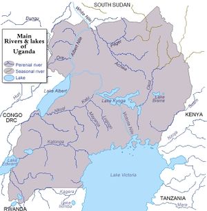
The Achwa River is a major river in northeastern Uganda which flows northwest into South Sudan where it is named the Aswa River and joins the White Nile.
The river begins in hills in the northwestern part of Katakwi Province and flows through Lira Province and becomes the border between the provinces of Pader and Gula where the Agago River and then the Pager River flow into it. The Achwa River forms most of the border between the provinces of Atiak and Gitgum before crossing into Sudan east of the border town of Nimule and joining the White Nile about ten miles northwest of Nimule. That particular section of the White Nile is known as Bahr el Jebel or "River of the Mountain", or Mountain Nile.
The Achwa drains much of the northeastern highland and northern plateau of Uganda.
Like most rivers in the region the flow of the Achwa is strongly influenced by the season and weather. It is prone to flooding at times. In 2000, it submerged the bridge connecting the cities of Gula and Kitgum.
The distance from the Achwa's headwaters to joining the White Nile is about 185 miles.
The river flows through East Sudanian savanna which encompasses much of northeastern Uganda. This hot, dry, wooded savanna composed mainly of Combretum and Terminalia shrub and tree species and tall elephant grass has been adversely affected by agricultural activities, fire, clearance for wood and charcoal, but large blocks of relatively intact habitat remain even outside protected areas. Populations of some of the larger mammal species have been reduced by hunting, but good numbers of others remain.
See Major rivers, lakes, mountains, and other terrestrial features of Uganda
