Yellowstone River
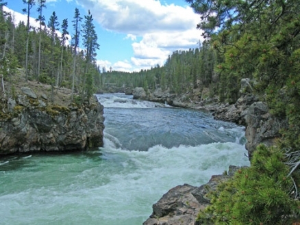
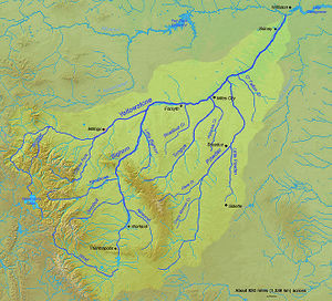
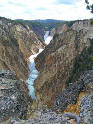
Yellowstone River rises in the Rocky Mountains in Wyoming, USA and flows generally eastward to discharge into the Missouri River. Its headwaters lie in Yellowstone National Park and the Gallatin National Forest, and its total course length is 1082 kilometres, making it one of North America's longest rivers; moreover, it the longest free-flowing river in the contiguous 48 states of the USA. A number of the headwaters tributaries manifest very high temperatures, due to the geyser fed streams rising in Yellowstone National Park.
After rising in the geothermally active headwaters region west of the Absaroka Range, the Yellowstone River flows north through the South Central Rockies forests, and then after turning northeast, it runs through the Northern short grasslands to Billings, Montana; thence it continues northeast to be joined by the Bighorn River; further it continues through the short grasslands to the Badlands of North Dakota. The chief water pollution concern in the Yellowstone Basin are elevated levels of fecal coliform bacteria in parts of the middle and lower basin, resulting from overgrazing on public lands stimulated by below market Federal grazing lease programs.
Contents
Geology
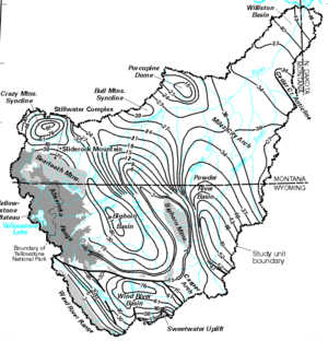
The Yellowstone Basin is comprised by three distinct geologic provinces: (1) Absaroka volcanic field; (2) Yellowstone Plateau; and (3) Basins and uplifts of the Rocky Mountains foreland. The first two units are Late Cretaceous to Paleocene volcanic elements, while the Bighorn, Beartooth, Owl Creek and Wind River Ranges are the chief uplifts. Basements of the uplifts feature shear zones, igneous dikes, foliation and small-scale folds. The Abrasoka volcanic field dates to the Tertiary is the largest volcanic province in the lower 48 USA states; it spans an areal extent of about 23,000 square kilometers and attains a maximum thickness of 1500 meters. Progressively younger eruptive zones moving to the southeast are noted, with vent zones mostly calc-alkaline stratovolcanoes and shield volcanoes.
Headwaters reach

The headwaters generally lie within the relatively dry South Central Rockies forests ecoregion; this ecoregion is actually centered primarily on the Yellowstone Plateau and the mountain ranges radiating outward from the plateau. This unit extends northward from the headwaters into central Montana. The landscape is characterized by dramatic vertical zonation of plantlifeand wildlife.
The dominant vegetation type in the ecoregion is coniferous forest. Küchler classifies the vegetation type as Douglas-fir/Spruce-fir forest, dominated by Engleman Spruce (Picea englemannii), Subalpine Fir (Abies lasiocarpa), and Douglas-fir (Psuedotsuga menziesii). Unique habitats occur in association with geothermal features which produce surface geysers and hot springs; distinct water chemistry micro-environments are created by hot water temperatures at these springs.
Mammals found in the upper reach of the Yellowstone Basin include the near-endemic American Bison (Bison bison, NT), Northern River Otter (Lontra canadensis); Pronghorn (Antilocapra americana); Yellow-bellied Marmot (Marmota flaviventris); Red-tailed Chipmunk (Tamias ruficaudus); and Pinyon Mouse (Peromyscus truei).
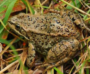
Amphibians occurring in the headwaters reach of Yellowstone River are the Northern Leopard Frog (Lithobates pipiens), Boreal Chorus Frog (Pseudacris maculata), Great Basin Spotted Frog (Rana luteiventris), Woodhouse's Toad (Bufo woodhousei), the Western Toad (Anaxyrus boreas).
Reptiles found in this upper reach of the Yellowstone Basin include the Western Gopher Snake (Pituophis catenifer); Painted Turtle (Chrysemys picta); Red-bellied Snake (Storeria occipitomaculata); and the Ornate Tree Lizard (Urosaurus ornatus).
Short grasslands reach
After experiencing the waterfall high gradient headwaters, the Yellowstone River descends from the Yellowstone Plateau to reach the Northern short grasslands. The terrestrial ecoregion here is populated by 337 species of vertebrates.
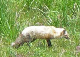
Notable Mammals found in the short grasslands are the Gray Wolf (Canis lupus); Black-tailed Prairie Dog (Cynomys ludovicianus); the Desert Cottontail (Sylvilagus audubonii); the Red Fox (Vulpes vulpes); Richardson's Ground Squirrel (Urocitellus richardsonii). One notable bird that breeds in the lower Yellowstone Basin (as its most northern range) is the Interior Least Tern (Sternula antillarum athalassos), a USA federally listed threatened species.
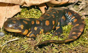
Amphibians occurring in this reach of the Yellowstone Basin are: the Wood Frog (Lithobates sylvaticus); the Striped Chorus Frog (Pseudacris triseriata); the Dakota Toad (Anaxyrus hemiophrys); Great Plains Toad (Anaxyrus cognatus); the Plains Spadefoot Toad (Spea bombifrons);and the Eastern Tiger Salamander (Ambystoma tigrinum), which is the largest and most widely distributed terrestrial salamander in North America.
Reptiles found in the short grasslands reach include the: Red-lipped Plateau Lizard (Sceloporus undulatus), Eastern Hog-nosed Snake (Heterodon platirhinos); False Map Turtle (Graptemys pseudogeographica); Sagebrush Lizard (Sceloporus graciosus ); the non-venomous Milk Snake (Lampropeltis triangulum). The Spiny Softshell Turtle (Apalone spinifera) is an aquatic taxon present in the lower Yellowstone Basin as well as the Missouri River Basin.
Fish species
When Yellowstone National Park became a national protected area in 1872, only a small fracton of the surface waters held any fish species; moreover, in an overzealous federal effort to stock fish, many of the alpine lakes and streams in the headwaters area became adversely affected by introduction of some of the alien species of fish brought in.
In the headwaters area of Yellowstone River within Yellowstone National Park, there are presently seven native fish species present: Arctic Grayling (Thymallus arcticus); Longnose Dace (Rhinichthys cataractae); Longnose Sucker (Catostomus catostomus grieus), only found below Yellowstone Falls; Mottled sculpin (Cottus bairdi), only found in reaches below Knowles Falls on the Yellowstone River and below Firehole Falls on the Firehole River; Mountain sucker (Catostomus platyrhynchus); Mountain Whitefish (Prosopium williamsoni), found only below Knowles Falls; and Yellowstone cutthroat trout (Oncorhynchus clarik bouvieri).
For the middle and lower reaches of the Yellowstone Basin notable fish taxa include the Blue Sucker (Cycleptus elongatus), which is listed as a species of special concern by the state of Montana due to habitat fragmentation and alteration, and because of the perceived vulnerability to rebound and recruit. Channel Catfish (Ictalurus punctatus) and Burbot (Lota lota) are both important elements of the recreational fishery of the Yellowstone Basin; Burbot is the only known cod species that can tolerate freshwater environments.
Shovelnose Sturgeon (Scaphirhynchus platorynchus) is abundant below the Cartersville Diversion, but functionally absent above that point.
Water quality
The most significant water pollution issue in the Yellowstone Basin are elevated levels of the bacterium Escherichia coli, which commonly violate the U.S. Environmental Protection Agency recommended limits, especially in the April/June period. E. coli is generally associated with fecal coliform. These violations occur in the middle and lower basin and are strongly correlated with river segments immediately downriver of intensive livestock grazing areas; these E. coli levels are often sufficiently high that swimming is considered unsafe in the affected river segments. Livestock herd concentrations that produce excessive fecal coliform runoff are one manifestation of overgrazing.
This adverse outcome is often associated with large expanses of Federal lands, where grazing leases are offerred at below market rates. To gain an understanding of the magnitude of the concessions below market, one needs to consider that the Federal government set the base lease rate of $1.23 per AUM (animal unit month) in the year 1966; one AUM is the amount of forage needed to support one cow plus calf (or five sheep) for a month. The present Federal lease fee in 2013 is $1.35 per AUM, indicating the Federal grazing base fee has nowhere nearly kept pace with inflation, and effectively taxpayers are subsidizing the fecal coliform pollution (Water pollution) of Yellowstone River and many other western USA watercourses.
Nitrate and phosphate concentrations are sometimes in excess of recommended standards in certain middle and lower basin locations. These issues are generally associated with localised areas of crop cultivation, where fertilizers are applied in excessive amounts, or without appropriate runoff controls.
References
- Aubrey L. Haines. 2000. The Lewis and Clark Era (1805–1814). Yellowstone National Park: Its Exploration and Establishment. U.S. Department of the Interior. Washington DC
- M.L. Clark and M.E. Gamper. 2003. A synoptic study of fecal-indicator bacteria in the Wind River, Bighorn River, and Goose Creek Basins, Wyoming, June-July 2000: U.S. Geological Survey Water-Resources Investigations. Report 03-4055, 43 pp.
- C. Michael Hogan. 2008. Douglas-fir: Pseudotsuga menziesii, GlobalTwitcher.com, ed. Nicklas Strõmberg
- Matthew Jaeger, Ken Frazer, Clark Nelson, Mike Vaughn, Brad Schmitz, Jim Darling. 2005. Movements and habitat use of Yellowstone native fishes and reptiles and nesting distributions of native birds. T2-25-2 Report. Montana Department of Fish, Wildlife and Parks. Miles City, MT
- Joel C. Janetski. 1987. Indians in Yellowstone National Park. Salt Lake City, Utah: University of Utah Press. ISBN0-87480-724-7.
- Kirk A. Miller, Melanie L. Clark and Peter Wright. 2004. Water quality assessment of the Yellowstone River Basin, Montana and Wyoming: Quality of fixed sites, 1999-2001. National Water Quality Assessment Program. U.S.Geological Survey. Report 2004-5113
- Paul Schullery and John D. Varley. 1998. Yellowstone Fishes: Ecology, History, and Angling in the Park. Mechanicsburg, Pennsylvania. Stackpole Books. ISBN0-8117-2777-7
- U.S.Department of Interior. 2013. Fact Sheet on the BLM’s Management of Livestock Grazing: Grazing on Public Lands. Bureau of Land Management. USDI, Washington DC
- U.S.Geologic Survey. 1998. Environmental setting of the Yellowstone River Basin. WRIR98-4269. U.S.Government Printing Office. Washington DC