Albertine Rift
| Topics: |
This content is not assigned to a topic
|
The Albertine Rift is a 1,200 km long rift valley in central Africa that is flanked by highlands, including some of the highest peaks on the continent, and includes a series of notable lakes, including Lake Albert, Lake Edward, Lake Kivu, and Lake Tanganyika. It is a region of high biodiversity, with many notable species found nowhere else, such the critically endangered Mountain gorilla.
The dominantenvironmental issue in the Rift region are reconciling human needs for land, firewood, and other natural resources and maintaining the scale and quality of habitat required by the species in one of the most biodiversity rich areas in the world. The Albertine rift is severely impacted by the wars and conflicts that have occurred in the Central Africa over the last few decades; and, by rapid population growth. However, it is also receiving significant attention form conservation groups and others who have had some success in bringing about the establishment of parks and other protected areas and supporting ecotourism as a sustainable economic force in the region.
Contents
Geography
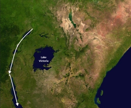
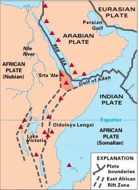
The Albertine Rift is part of the Great Rift System, which runs from the Jordan Valley in the Middle East, through the Red Sea and south through eastern Africa to Mozambique which is created by the cracking ("rifting") of the tectonic plate carrying the African continent. In equatorial Africa, the Rift System has two branches, the eastern branch is often referred to as the Great Rift Valley or Eastern Rift Valley. The western branch is more commonly known as the Albertine Rift or the Western Rift Valley.
Location: The Rift runs north-south with a westerly arc and provides a natural border for Democratic Republic of the Congo and its western neighbors, Uganda, Rwanda, Burundi, and Tanzania. Some observers include all of Lake Tanganyika within the Albertine Rift and thus Zambia might be considered a sixth nation with Albertine Rift territory
Geographic Coordinates: The Albertine Rift has no precisely defined boundaries. The northern end is usually taken to include all of Lake Albert which ends at the beginning of the Albert Nile (2°21' N 31°27' E). The southern end is usually taken to include most, but not all, of Lake Tanganyika, terminating at about the latitude of the Marungu Highlands (7°30’ S).
Area: The "great circle distance" between the north end of Lake Albert and the Marungu Highlands is 685 miles (1,100 km). The westerly arc of the rift increases its overall length to approximately 750 miles (1,200 km) long. The valley width is typically 30-50 km (20-30 miles) wide. The Albertine Rift region to usually taken to include the the flanking mountains and nearby areas.
Natural Hazards: Volcanic activity.
Mountains: The rift valley is flanked by (from north to south): the Blue Mountains, Ruwenzori Mountains (often called "the Mountains of the Moon"), Virunga Vocanoes (also calledthe Mufumbiro Vocanoes), Mitumba Mountains, Mahale Mountains, and Marungu Mountains.
Terrain: The highest point in the mountains flanking the rift valley is Margherita Peak on Mount Stanley (5,110 metres) in the Ruwenzori Mountains which sit on the border between Uganda and the Democratic Republic of the Congo north of Lake Edward.
Ecology and Biodiversity
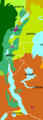
 Ecoregions of the Albertine Rift. Source: WWF
The Rift is dominated by the Albertine Rift montane forests (AT0101 in the coded map left from the World wildlife Fund). However a number of other ecorgions are found in the Albertine Rift:
- Northern Congolian forest-savanna mosaic (AT0712)
- Northeastern Congolian lowland forests (AT0124 - dark green region on the left of the map)
- Ruwenzori-Virunga montane moorlands (AT1013)
- Victoria Basin forest-savanna mosaic (AT0721)
- Central Zambezian Miombo woodlands (AT0704)
- Itigi-Sumbu thicket (AT0708)
The Albertine rift is one of Africa’s most species rich and endemic-rich regions, despite being one of its most poorly documented. The other ecoregions add to the rich ecological tapestry of the region and to is biodiversity.
While the biodiversity of the Albertine Rift is still poorly know, it is clear that this small area includes a high fraction of the species found on the African continent and a large number of species that are only found in the Rift region (i.e., are endemic to the region). Further, many species are threatened. The following table, drawn from the Wildlife Conservation Society's Albertine Rift Programme, quantifies what is known at this time.
|
|
|
|
|
|
|
|
|
|
|
34 |
|
|
|
|
|
41 |
|
|
|
|
|
16 |
|
|
|
|
|
34 |
|
|
|
|
|
|
|
|
|
|
|
Source: Wildlife Conservation Society.
Protected Areas
See Protected Areas of the Albertine Rift
Although there are a number of National Parks and Forest Reserves in the area, the recent wars have made their management difficult over much of the ecoregion. Additional threats include conversion of most forest areas outside reserves into farmland, together with logging, firewood collection, and bushmeat hunting within the remaining forest areas.
|
Burundi
Democratic Republic of the Congo
Rwanda
Tanzania
|
Uganda
|
Source: World Database on Protected Areas, Wildlife Conservation Society.
Lakes (Transnational except Lake George)
- Lake Albert
- Lake George
- Lake Edward
- Lake Kivu
- Lake Tanganyika
Governance, Wars and Civil Conflict
The Albertine Rift region includes parts of 5 countries, Uganda, Rwanda, Burundi, Tanzania, and the Democratic Republic of the Congo. Some observers include all of Lake Tanganyika within the Albertine Rift and thus Zambia might be considered a sixth nation.
The protected areas list above are therefore governed by a wide diversity of agencies operating under different laws and policies, with different levels of commitment and capacity to manage the habitats, wildlife and natural resources under their jurisdiction. Further the growing populations combined with various types of civil unrest places huge demands of the limited financial resource and governance capacity in the region. In recognition of the high value environmental value of the Albertine Rift, support in provided by international institutions and conservation organizations to helps local efforts.
Over the past two decades, four of the Albertine rift nations nation's have been involved in regional wars and internal civil conflicts that have involved movements of refugees and malitias, and breakdowns in governance, which have had impact on the Albertine Rift. These include:
- In 1990 a civil war began in Rwanda between ethnic Tutsis drawn from a population of some 150,000 that had been driven into exile in neighboring countries in prior years by a government dominated by ethnic Hutus.
- Burundi's first democratically elected president was assassinated in October 1993 after only 100 days in office, triggering widespread ethnic violence between Hutu and Tutsi factions.
- Rwanda's civil war, along with several political and economic upheavals, exacerbated ethnic tensions, culminating in April 1994 in the genocide of roughly 800,000 Tutsis and moderate Hutus. The Tutsi rebels defeated the Hutu regime and ended the killing in July 1994, but approximately 2 million Hutu refugees - many fearing Tutsi retribution - fled to neighboring Burundi, Tanzania, Uganda, and Democratic Republic of the Congo.
- Ethnic strife and civil war, touched off by a massive inflow of refugees, led in May 1997 to the toppling of the DRC government by a rebellion backed by Rwanda and Uganda.
- In August 1998, the new DRC government was itself challenged by a second insurrection backed by Rwanda and Uganda and recieved support from other intervening nations. A 1999 cease-fire, reduced the conflict but sporadic fighting continued. The 2002 Pretoria Accord signed by all remaining warring parties led to end the fighting in the DRC.
- During this period, continuing conflict led to hundreds of thousands of Burundians being internally displaced or becoming refugees in neighboring countries, and more than 200,000 deaths. A 2003 power-sharing agreement between Tutsis and Hutus rebels paved the way for a transition toward peace.
- Civil conflicts with various malitias have continued sporadicaly to the present.
In all of these conflicts, warring parties have move across the Albertine Rift, often establishing camps and bases in the region. The environmental impact has been immense. For example, endangered species like gorillas have been killed in crossfire, animals are killed for food, and forests cut down for firewood. In the mid 1990's, the number of Eastern lowland gorillas in Kahuzi-Biéga National Park of the DRC was estimated to be about 8,000; today the number may be a low as 1,000, accounting for most of the 50% drop in the overall population of Eastern gorillas.
People and Society
Even without the wars and civil conflict, pressures on the environment are significant in the densely populated rural area. In many areas the only stands of forest remaining are within Forest Reserves or National Parks, or those stands found in the most mountainous and therefore inaccessible areas. Continuing population growth, demands for natural resources and economic development make the Albertine Rift region a major challenge for conservations.
The nations of the Albertine Rift are also challenged by having some of the lowest Human Development Index rankings in the world. Of 187 nations in the index the five Albertine Rift nations rank near the bottom:
152. Tanzania
161. Uganda
166. Rwanda
185. Burundi
187. Democratic Republic of the Congo
These rankings result from a combination of low life expectancy, low literacy, poverty, and other measures of human development.
Ecotourism, centered around such charismatic species as the Mountain gorilla has been a successful strategy to reducing the tension between people and wildlife. The industry provides jobs and revenue to the local economy and appreciation for wildlife and their habitats to local communities; and thus incentives for the continued protection of habitat.
Further Reading
- Africa's Great Rift Valley by Pavitt Nigel, Harry N. Abrams publisher, 2001ISBN: 0810906023
- The Great Rift: Africa's Changing Valley by Anthony Smith, Sterling Publishing, 1989 ISBN: 0806969067
- The Physical Geography of Africa by William Adams, Andrew Goudie, and Antony Orme (Editors), Oxford University Press, USA, 1999 ISBN: 0198234066
- World Atlas of Great Apes and Their Conservation],Julian Caldecott and Lera Miles (Editors), University of California Press, Berkeley, 2005. ISBN: 0520246330.
- Albertine Rift Programme, Wildlife Conservation Society (accessed June 17, 2009)
[../149959/[Albertine Rift] collection]


