Weeks Bay National Estuarine Research Reserve, Alabama
Contents
Introduction Weeks Bay Reserve boundary map. (Source: NERRS (Weeks Bay National Estuarine Research Reserve, Alabama) )
Weeks Bay is a small estuary, about 3 sq. miles (8 sq. kilometers), receiving fresh water from the Magnolia and Fish rivers, and drains a 198 sq. mile watershed into the portion of Mobile Bay. This sub-estuary of Mobile Bay averages just 4.8 ft deep (1.5 meters) and is fringed with marsh (Spartina, Juncus) and swamp (pine, oak, magnolia, maple, cypress, bayberry, tupelo and others). The reserve lands also include upland and bottomland hardwood forests, freshwater marsh (Typha, Cladium), submerged aquatic vegetation (Ruppia, Valisneria) and unique bog habitats (Sarracenia, Drosera). Weeks Bay is a critical nursery for shrimp, bay anchovy, blue crab and multitudes of other fish, crustaceans and shellfish that support robust commercial fisheries providing $450 million/year for Alabama.
The Weeks Bay Reserve includes over 6,000 acres of coastal wetlands and waterbottoms that provide rich and diverse habitats for a variety of fish, crustaceans and shellfish, as well as many unique and rare plants. The Weeks Bay estuary, "where rivers meet the sea,” is an important site of scientific research on estuarine ecology. The Weeks Bay Interpretive Center offers the public opportunities to learn about coastal habitats through its exhibits, live animals displays and collections of animals and regional plants. Self-guiding nature trails wind through wetlands, marshes, bogs and forests.
Weeks Bay Reserve is within the National Estuarine Research Reserve System (NERRS), a network of estuarine habitats protected and managed for the purposes of long-term research, education, and coastal stewardship. Established by Congress in 1972 as part of the Coastal Zone Management Act (CZMA), the NERRS is administered as a partnership between the National Oceanic and Atmospheric Administration (NOAA) and the coastal states.
Site Description
Flora
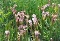 White-Topped Pitcher Plants (Sarracenia leucophylla) (Source: NOAA)
 Fish River, Magnolia River and several small tidal streams in the Weeks Bay area are bordered by a forested wetland type known as bay, tupelo, and cypress swamp. The vegetation of these swamps varies depending partly on the amount and duration of flooding. If flooding is extensive, pond cypress and swamp tupelo may dominate the canopy. Red maple, swamp tupelo, swamp bay and tulip may also occur there. White cedar becomes increasingly more common in swamps along upper reaches of streams, especially along Fish and Magnolia rivers. Few plants live under the dense shade of these trees, some of the exceptions being Virginia willow, star anise and fetterbrush.
The more open borders of these swampy woods may be covered by dense thickets of swamp cyrilla, black titi and large gallberry. The transition zone between these forested wetlands and the upland pine-oak forests supports plants adapted to somewhat better drainage conditions, such as water oak and laurel oak. The shoreline of Weeks Bay supports marshes dominated by salt-tolerant herbs and grass-like plants, with black needlerush dominating portions of the marsh in the area.
Two species of cordgrass (Spartina alterniflora and S. cynosuroides) are locally abundant in the intertidal zone. Other frequent species are salt grass, saltmeadow cordgrass, salt marsh aster, marsh gardenia and sea lavender. Submerged grassbeds have decreased over the decades. Remaining grassbeds are dominated by four species. The most abundant is widgeon grass. Other species are Eurasian waterfoil, tapegrass and slender pondweed.
Fauna
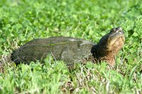 Common Snapping Turtle (Chelydra serpentina). (Photo by Marlene Cashen)
 The reserve is a productive nursery for shrimp and other commercially important fish and shellfish, as well as many marine species, such as the spotted sea trout, red drum, croaker, flounder, mullet and menhaden. The reserve is home to more than 180 species of fish. Fish populations in the area include freshwater and marine species. The reserve is also home for three endangered fish species.
The reserve serves as habitat for over 330 species of birds, including 100 resident species, 125 wintering species and 85 spring and fall migrants. This area is of special importance to the large number of trans-Gulf migrants as a resting and feeding area.
The reserve is also home to more than 50 mammals, three of which are endangered (the Florida black bear, the marsh rabbit and the bayou gray squirrel), living within the 10 foot contour in the [[coastal] zone] of Alabama, with most found in the Weeks Bay area. Other residents include over 70 species of reptiles (eight endangered) and 40 species of amphibians (two endangered).
Endangered Species
The Weeks Bay system provides habitat for as many as 19 threatened species. Among the federally listed Threatened and Endangered Species and Species of Special Concern that reside or are found within the Weeks Bay watershed include the bald eagle, Alabama red-bellied turtle, gulf sturgeon, the alligator snapping turtle and the alligator map turtle. The endangered Alabama shovelnose sturgeon is also found in Weeks Bay. Four endangered snakes are found in the reserve—the Gulf salt marsh snake, the eastern indigo snake, the Black pine snake and the Florida pine snake. The endangered Florida black bear is also found there.
Tidal Range and River Flow
Tidal range in the estuary is from 0.3 - 0.5 meters (1.0 - 1.5 feet).
Weeks Bay has two major freshwater inflows, the Fish River from the north and the Magnolia River from the east. Mean combined discharge is estimated at nine cubic meters/second, with freshets up to four times larger. The Fish River accounts for approximately three-quarters of this freshwater inflow. During extreme flooding the Fish River has been estimated at 243 cubic meters/second. While the Fish and Magnolia Rivers have depth ranges from two-14 meters (six-42 feet), Weeks Bay averages less than five feet deep, with its western half three feet or less. The drainage basin of the Fish River can respond rapidly to local rainfall. Estimates of the replacement for water within Weeks Bay from freshets are two or three days to refill the Bay. Normal tidal exchange can do the same at three days. The salinity of Weeks Bay is strongly coupled to the salinity of the Mobile Bay estuary, which is controlled by the extensive seasonal runoff of the Mobile River system, and only secondarily a function of freshwater input from the Weeks Bay watershed.
Soil Types
The Weeks Bay Reserve is characterized by two types of surface soils—Malbis-Orangeburg-Pansey Association and Dorovan-Plummer-Tidal March Association. The Malbis-Orangeburg-Pansey Association is deep, moderate to well-drained, level to gentle sloping, sandy clay loams. The Dorovan-Plummer-Tidal March Association is variable, depending on location, normally level, poorly drained, organic soils.
Research
 Periodic burning, properly controlled, can greatly prolong the life of a bog. (Source: NOAA)
 The reserve’s research program has provided scientists with support of laboratory and office facilities, equipment and personnel. Southern Alabama’s unique environment, and the abundance and diversity of species provide multitudes of research opportunities for the coastal scientist.
The reserve supports student research through NOAA’s Graduate Research Fellowship Program. Other areas of scientific research include sedimentation, nutrient enrichment, ecological function, modeling of estuarine processes, effects of development on land use and the consequences of development on coastal and estuarine ecosystems. Efforts continue in monitoring invasive aquatic species, water quality and atmospheric conditions.
The reserve also offers training for volunteer water quality monitors participating in the Weeks Bay Chapter of Alabama Water Watch, a volunteer citizen water quality monitoring organization administered by Auburn University.
Additionally, the reserve’s stewardship program offers data and information to local decision-makers, home-owners, developers and farmers, working to protect and preserve the productive and fragile habitats unique to the northern Gulf Coast.
Cultural History
Prior to the exploration and settlements of Spanish explorers in the early 16th Century (1519-1670), the Weeks Bay/Mobile Bay region was dominated by the Creek Indians, the most powerful tribe in present day Alabama. The Creeks had their own language, which was the official tongue of the region. The area was later fought over and settled by the French in the late 17th Century (1670-1763), followed by the British for a short time in the mid-18th Century (1763-1783), and briefly again by the Spanish (1780-1813). Alabama joined the Union and obtained statehood in 1816, and seceded in 1861 with 10 other states to form the Confederate States of America with its first capital at Montgomery, Alabama. During the spring of 1865, Union forces moved through Weeks Bay and up the Fish River, beginning the Siege of Mobile. The battles of Spanish Fort and Blakeley were fought during the week before General Lee surrendered at Appomattox, Virginia.
Partners and Supporters
The Weeks Bay Reserve is administered by the Alabama Department of Conservation & Natural Resources, with additional support from the 500-member nonprofit Weeks Bay Reserve Foundation. Several advisory committees assist to guide the reserve, and a strong volunteer base assists with water quality monitoring, conducting programs for school classes, native plant landscaping and other organizational tasks. The reserve participates in a web-based distance-learning project in cooperation with Faulkner State Community College. Numerous research, education and management partnerships are active with several federal, state and local agencies, primarily focused on water quality, sedimentation, native species, wetlands, productivity and habitat.
Further Reading
| Disclaimer: This article is taken wholly from, or contains information that was originally published by, the National Oceanic and Atmospheric Administration. Topic editors and authors for the Encyclopedia of Earth may have edited its content or added new information. The use of information from the National Oceanic and Atmospheric Administration should not be construed as support for or endorsement by that organization for any new information added by EoE personnel, or for any editing of the original content. |