Waterfowl Production Areas
Waterfowl Production Areas (WPAs) are wetlands and grasslands set aside for the production of waterfowl and other wildlife species. These public lands, managed by the U.S. Fish and Wildlife Service, were included in the National Wildlife Refuge System in 1966 through the National Wildlife Refuge Administration Act.
The Duck Stamp Act, passed in 1934, was amended by Congress in 1958 to authorize acquisition of wetlands as WPAs. Thus began one of the most aggressive acquisition campaigns in history; a race against drainage tile and ditches.
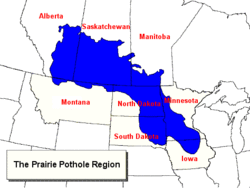
Nearly 95 percent of WPAs are located in the prairie pothole areas of North and South Dakota, Minnesota, and Montana. North Dakota alone has 39 percent of the Nation's WPAs. Other key states are Michigan, Nebraska, Wisconsin, and Iowa. Idaho and Maine each have one WPA.
There are over 26,000 WPAs and they average 223 acres in size. The smallest is .9 acres (Medicine Lake WPA, North Dakota) and the largest is 3,733 acres (Kingsbury Lake WPA, Montana).
The first WPA purchased with Duck Stamp funds was the McCarlson WPA in Day County, South Dakota on January 19, 1959. Some WPAs have been donated as gifts, while a few have been reserved from public domain lands.
Wetland Management Districts (WMDs) were created in 1962 as the acquisition program accelerated due to a loan from Congress against future Duck Stamp sales. WPAs are managed by WMD staffs of 2-12 people: wildlife managers, biologists, technicians, maintenance workers, and administrative specialists.
WMD staff also manage wetland easements; perpetual contracts with willing private landowners that protect their wetlands from draining and filling with soil. To date, nearly 25,000 easements have been acquired, covering 1.6 million acres. In recent years, grassland easements have been purchased to provide permanent grassland cover around wetlands to meet the needs of upland nesting waterfowl and other wildlife.
Prairie wetlands, or "potholes," are the lifeline for fish and wildlife of the entire prairie landscape from the Rockies to Wisconsin. If wetlands in this vast Prairie Pothole Region were not saved from drainage, hundreds of species of migratory birds would literally have gone down the drain.
Although WPAs and National Wildlife Refuges account for less than 2 percent of the landscape in the Prairie Pothole Region states, they are responsible for producing nearly 23 percent of the area's waterfowl. Just as important, staff at WMDs work extensively with private landowners through voluntary partnerships that enhance private lands for waterfowl and other wildlife.
The Rainwater Basin WMD in Nebraska is one of the most important stopover areas for waterfowl in North America. Approximately 2-3 million geese and 7-9 million ducks use the area for a few weeks between February and April each year as they wing their way to the breeding grounds.
WPAs protect a large portion of the remaining tallgrass prairie found in the Midwest. Helikson WPA in northwest Minnesota contains 1,373 acres of virgin prairie with grasses over 6 feet tall.
The Coteau Prairie WPA in northwest North Dakota is believed to contain the largest tract of mixed grass prairie on any WPA—2,754 acres.
Beaver Lake WPA in North Dakota harbors the largest Franklin's gull colony of any WPA. In recent years, 250 nests of the black-headed gulls have been counted. Bobolinks, striking cream- and black-colored grassland birds, rely on the grasslands found on WPAs. The population of these robin-sized birds, which winter in Argentina, would likely crash without WPAs.
Several threatened or endangered species, especially prairie plants such as the western prairie fringed orchid, rely heavily on WPA habitat for survival. The Fuller WPA in northwestern North Dakota was purchased to protect nesting threatened piping plovers and for waterfowl production. Other rare or unique species recorded on WPAs in the West include grizzly bears, mountain lions, bobcats, blue grouse, and wolverines.
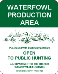
By regulation, WPAs are open to hunting, fishing, and trapping in accordance with State laws. Other important wildlife-dependent uses allowed include wildlife observation, photography, and environmental education. Nearly 800,000 people visit WPAs yearly. WPAs in the Huron WMD in South Dakota get over 100,000 visitors per year—more than any other WMD.
WPAs are usually named after the owner who sold the land to the Fish and Wildlife Service, while a few stick with names given by local residents. Some unusual WPA names are: Mosquito Ranch, Humpty Dumpty, Robin Hood, Maga TaHohpi (Yankton Sioux for "duck nest"), Gomer Trout, Old Adeline, Duck Haven, and Kicking Horse!
The Blackfoot River, made famous in the book and movie, "A River Runs Through It," winds through the Blackfoot WPA in Montana.
Plover WPA, in Lac qui Parle County, Minnesota, has granite bedrock outcrops exposed 10,000 year ago by a glacial river. The bedrock is said to be some of the oldest in the world.
Dougout Creek WPA in Dickinson County, Iowa, is home to 16 fens (wetland seeps with unique plants), one of the largest fen complexes in the Midwest.
Jarina WPA, at the foot of the east face of the Rockies in Montana, is the windiest WPA. Fierce southerly winds, known as Chinooks, reach 100 mph each year and tear bolted boundary signs from their posts!
| Disclaimer: This article is taken wholly from, or contains information that was originally published by, the U.S. Fish and Wildlife Service. Topic editors and authors for the Encyclopedia of Earth may have edited its content or added new information. The use of information from the U.S. Fish and Wildlife Service should not be construed as support for or endorsement by that organization for any new information added by EoE personnel, or for any editing of the original content. |


