Water profile of Japan
Contents
Geography and population
Japan (36°00' North, 138°00' East) is an archipelago that stretches 2,600 km in an arc running northeast to southwest through the North Pacific. The Sea of Japan and the East China Sea separate Japan from the Asian landmass. The archipelago lies mostly between 25° and 45° N with a total land area of 376,520 km2. The five main islands, Honshu, Hokkaido, Kyushu, Shikoku and Okinawa, account for about 96 percent of the total land area though there are more than 3,300 other islands. About 70-80 percent of the country is mountainous. The mountains in the central part of Honshu are more than 3,000 m high. The Fuji mountain is the highest point at 3,776 m above sea level.
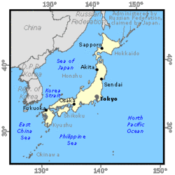 Map of Japan. (Source: FAO-Forestry)
 In 1996, the cultivated land area was 4,776.000 hectares (ha), which is 96 percent of the total cultivable area. The cultivated land area is declining gradually as it is needed for housing or industrial uses. About 4,384.000 ha, or 92 percent of the cultivated area, consist of annual crops, of which paddy fields occupy 2,560,000 ha. Cropping intensity of this land just exceeds 100 percent. The area under permanent crops is estimated at 392,000 ha.
In 1996, the population of Japan was estimated at 125,351,000 inhabitants (22 percent rural). The average population density is 332 inhabitants/km2, which makes Japan one of the most densely populated countries in the world. About 70 percent of the population is concentrated in the coastal zone extending from the capital, Tokyo, to the northern part of Kyushu island. Despite a low birth rate, it is projected that Japan's population will still be increasing at an annual rate of 0.2 percent up to 2,000, mostly as a result of increased life expectancy. However, it is expected that after 2005 the annual growth rate will be 0 percent.
In 1995, there were 2,651,000 farm households with a population of 15,084,000 inhabitants. Five out of every six households are part-time farmers who also earn income from other jobs. There are another 792,000 households owned by part-time farmers who cultivate small plots for personal consumption and do not produce any surplus crops for sale. Japan's agriculture contributed approximately 2.1 percent of the nation's gross domestic product (GDP) in 1995, and provided employment for just over 5 percent of all employed persons in 1996.
Climate and water resources
Climate
Most parts of Japan are within the north temperate zone with four seasons a year. However, the length of the archipelago and the ocean currents along the coasts lend a wide variety of climates to Japan. Due to their proximity to the Asian landmass, the major islands of Japan are subjected to seasonal winds. These winds and the mountainous backbone divide the major landmasses into two typical climatic zones: the Pacific coast climatic zone and the Sea of Japan climatic zone, which have different seasonal distributions of precipitation. The difference in climate between the two zones is caused by the summer monsoon, which blows from the Pacific Ocean bringing warmer temperatures and rain, and the winter monsoon from the Asian landmass, which brings freezing temperatures and heavy snowfalls to areas on the Sea of Japan side. Thus, the weather on the Pacific Ocean side of Japan is warm and humid in summer (June-August), while it is dry and windy in winter (December-February). The regions facing the Sea of Japan receive a lot of precipitation in the form of snow from December to February.
The mountainous topography of the interior also forms special weather pockets in the Inland Sea and the central highlands. The former is characterized by the lowest amount of precipitation, and the latter by extremely variable weather throughout the year. Japan is often struck by typhoons, some of which bring a huge amount of rainfall in August and September. The rainy season lasts from June to mid-July. The mean annual precipitation is 1,728 mm, ranging from 800 mm in the north of Hokkaido island to 3,600 mm in the south of the country. Though Japan would appear to have plentiful water resources, it is so densely populated that the annual amount of rainwater per capita is only 3,430 m3. Moreover, this amount varies significantly with area and time.
River basin and water resources
In Japan, there are more than 2,700 river basins. Among them, 109 rivers are designated as being managed by the central government in principle because of their major importance to the economy and to the protection of the environment. The catchment area of these Class A rivers covers about 239,900 km2. Class B rivers consist of the other rivers which are managed at a lower level.
Only ten rivers exceed 200 km in length. The longest, the Shinano River, winds through the Nagano and Niigata prefectures of Honshu island and empties into the Sea of Japan. It is 367 km long and has a specific runoff of 1,389 m3/s/km2. Average surface water resources are estimated at 420 km3/year.
There are 247 freshwater aquifers underlying a total area of 69,130 km2. The renewable potential of groundwater resources is estimated at about 27 km3/year, though because of the steep slopes, a significant part (estimated at 17 km3/year) probably returns to the river system. Where land subsidence, saline intrusion and excessive lowering of the water table have occurred, groundwater use has been restricted to a safe yield by applying legal regulations and ordinances to critical areas. The total annual renewable water resources are estimated at 430 km3/year.
Lakes and dams
More than 600 lakes are scattered among the seaside districts and the volcanic zones. The major lakes in the country are:
- Biwa-ko, which lies in the inland basin near Kyoto in central-west Honshu with an area of 674 km2 and a water volume of 27.5 km3;
- Kasumi-ga-ura, which is close to the mouth of the Tone-gawain with an area of 220 km2 and a water volume of 0.848 km3;
- Inawashiro-ko, which is a lake created after a volcanic eruption in northwest Honshu with an area of 104.8 km2 and a water volume of 3.86 km3.
The history of dams and reservoirs in Japan dates back many centuries, and a number of ancient earthen dams are still used for paddy irrigation. Since the 1920s, technological advances have led to the construction of dams and weirs with modern designs, and these have contributed mainly to irrigation development and hydropower generation. The construction of large-scale multipurpose dams including flood control began in the 1950s to meet increasing water demand for municipal and industrial use as well as irrigation. In 1993, there were 2,556 dams over 15 m high in service for water supply, hydropower generation and flood control, for a total effective storage capacity of 16.5 km3. In addition, 587 dams under construction at that time were planned to provide 7.7 km3. The total storage capacity of all these dams is about 29 km3. A 1990 survey showed that another 4.8 km3 were provided by small dams. In 1996, the installed capacity of all power plants in operation was 226,994 megawatts (MW), of which 21,171 MW or 19 percent was hydropower.
Water withdrawal
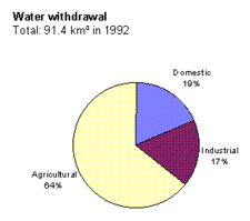 Figure 1: Water withdrawal in Japan (Source: FAO)
 In 1992, the total water withdrawal for agricultural, domestic and industrial uses was 91.4 km3. The amount of water withdrawn for agricultural purposes in 1992 was estimated at 58.6 km3, which represents 64 percent of the total water withdrawal (Figure 1). With the exception of 3.9 km3 from groundwater, almost all water comes from rivers and small reservoirs in the fields. Out of 58.6 km3, 55.9 km3 (95.4 percent) is used for the irrigation of paddy fields, 2.2 km3 (3.8 percent) for the irrigation of non-rice fields, and the rest for livestock farming. The amount of water withdrawn for industry is estimated at 15.8 km3, and that for domestic purposes at 17 km3. About 9 km3 of groundwater is annually withdrawn for industrial and public use. This amount has gradually been reduced through efforts to recycle the water used in the industrial sector.
Other sources of water include recycled sewage and industrial wastewater as well as the desalination of seawater. The amount of water involved remains small compared with river water, but it is growing gradually. The volume of treated water re-used in 1993 was 11,370 million m3. In 1995, the desalination capacity of plants was 69,500 m3/d. In addition, another project to establish a desalination plant has recently started in Okinawa prefecture with a capacity of 40,000 m3/d. A first stage of 10,000 m3/d was completed in February 1996.
Large amounts of water are also required for freshwater fish cultivation. About 8.2 km3 of water was reportedly allocated for this purpose in 1991, of which 29.5 percent was withdrawn from aquifers.
Irrigation and drainage development
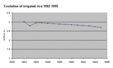 Figure 2: Evolution of irrigated rice in Japan. (Source: FAO)
 Rice cultivation dates back about 2,000 years, and irrigation did not lag behind. Since then, land reclamation for rice cultivation has spread as the population has grown. In the early decades of this century, several irrigation schemes were undertaken as national projects. However, it is since the 1940s that a number of irrigation projects have been extensively carried out nationwide not only by the central government but also by local governments and Land Improvement Districts (LIDs) through subsidies.
In the 1940s, irrigation projects either modernized old systems or provided new ones often associated with land reclamation for paddy. They included the construction of dams for increased water supply and of weirs to unify intakes. Later integrated with farmland consolidation projects, many projects have had the objective of reorganizing irrigation networks to facilitate water distribution and meet increased water requirements as a result of improved drainage.
With the need to adjust to a changing residential environment, the development of irrigation has tended to move to the construction of pipeline systems instead of open channels, a fact which has also led to more effective water use. Due to the overproduction of rice in the early 1970s, resulting from an increase in yields and a decrease in consumption, efforts have been made to plant non-rice crops on paddy fields such as wheat, corn, beans and vegetables. The expansion of irrigation systems to dryland crops is being carried out in various parts of the country (Figure 2).
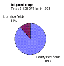 Figure 3: Irrigated crops in Japan. (Source: FAO)
 In Japan, irrigation is used predominantly for rice cultivation through basin irrigation. Cultivation techniques and mechanized farming require several drainages during one cropping season. This leads to water loss in the fields. Furthermore, the percolation rate in paddy fields through vertical drainage is relatively high, so leading to poor on-farm irrigation efficiency. However, water that returns to a river is re-used by other irrigation systems downstream. Thus, densely developed and stratified irrigation systems contribute to good water use efficiency at river basin level.
In 1993, the total area of land equipped for full or partial control irrigation was estimated at 3,128,079 ha. Almost all paddy fields are irrigated, and little rainfed land remains. In addition, irrigation for non-rice fields reached 346,668 ha in 1993 (Figure 3).
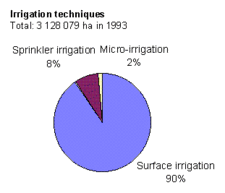 Figure 4: Irrigation techniques in Japan. (Source: FAO)
 Groundwater is used mainly to satisfy supplementary irrigation water requirements during the low water season from April to September, and especially in August. The total area of land benefiting from supplementary irrigation from groundwater is estimated at 500,000 ha. More than 90 percent of it is paddy fields, the remainder being upland fields, orchards and grasslands. Irrigation facilities using groundwater are generally designed on a smaller scale than those based on surface water from streams and reservoirs.
Most irrigation systems for paddy fields are of the gravity type though some have pumping stations to lift water from rivers or other sources. For upland fields, sprinkler irrigation is usually applied. Drip irrigation is used mainly in greenhouses (Figure 4).
The central government finances one-third of the cost of construction through loans to local government and beneficiaries. Projects operated by local governments and LIDs receive subsidies from the central government of 50 and 45 percent of their cost respectively. The remaining costs are usually shared by both. Users or LIDs operate and maintain the systems at their own expense including those projects completed by the central government, though there are some exceptions.
Drainage projects have been carried out successfully in flood-prone areas to protect land from excessive inundation. Farmland consolidation projects, implemented widely in the country, include the improvement of on-farm irrigation systems and of surface or subsurface drainage. The improved drainage systems also contribute to the conversion of paddy land to land suitable for non-rice cropping.
Institutional environment
Water resources development and management in Japan are conducted by various institutions. The National Land Agency is responsible for the overall planning and coordination concerning land and water. The agency formulates water resources development plans in cooperation with other relevant governmental organizations.
The Ministry of Construction administers affairs concerning river conservation as stipulated by the River Law. It implements flood control, erosion control and river retention for Class A rivers. It is also in charge of the construction and management of multipurpose dams.
Public water services are supervised by the Ministry of Health and Welfare. Industrial water and hydropower generation are supervised by the Ministry of International Trade and Industry.
The Environment Agency is responsible for setting standards for water quality and for carrying out water pollution control.
The Ministry of Agriculture, Forestry and Fisheries is responsible for irrigation and drainage. In accordance with Japan's Basic Agricultural Law, the Ministry prepares long-term prospects for agricultural demand and production to direct its policies in each area of agriculture. The Ministry formulates a fundamental policy or long-term plan for land improvement based on the Land Improvement Law, setting specific goals every ten years and the amount of investment for farmland improvement. Individual projects stated in the plan are carried out in accordance with an agricultural and rural development program which covers a wide range of developments such as irrigation and drainage, farmland consolidation, disaster prevention, reclamation of agricultural land, improvement of rural water supply and sewage in rural communities. Its activities include the planning and execution of national projects as stated by the rules and regulations of the Land Improvement Law, and supervising subsidized projects.
The main body responsible for the implementation of an irrigation project (which may be the central government, a prefectural government or an LID) is determined by the scale of the project defined according to the area involved. In a typical case, the central government takes responsibility where the beneficiary area is more than 3,000 ha of paddy field; the local government where more than 200 ha are involved; and LIDs for schemes of more than 20 ha. Construction projects operated by central and local government are limited to the canal sections that command at least 500 and 100 ha respectively. To complete an entire irrigation system in a project area, these three entities work together in an integrated manner in accordance with their responsibilities.
Trends in water resources management
In the current long-term plan for land improvement which began in 1993, it was decided to allocate funds of ¥41,000,000 million (US$369,000 million at the 1993 exchange rate), of which 15 percent is accounted for by irrigation and drainage, and 54 percent by farmland consolidation targeting 900,000 ha for paddy fields and 500,000 ha for dryland. The initial budget for the 1995 fiscal year was ¥2,024,000 million. To conform with the Uruguay Round Agreement in 1995, the Government has accelerated implementation of its agricultural and rural development program to develop a strong agricultural structure and promote a production environment through efficient and stable agricultural management.
Figure 2 shows that the area of paddy fields continues to decrease due to urbanization. In addition, production control of rice will probably remain in effect for some time, a fact which might lead to a decrease in water consumption for rice cultivation. Nevertheless, the total water withdrawal cannot be expected to fall in proportion to a decrease in irrigated paddy land because much of the land converted from rice cultivation for housing or for other crops can be found relatively isolated in the middle of, or adjacent to, paddy fields, so contributing to a decrease in river basin water use efficiency. In addition, water requirements for rice tend to increase because of a prolonged irrigation period due to the increased use of planting equipment, which is able to handle only younger seedlings, and because of the introduction of improved cultivation techniques. Upland irrigation is also expected to increase steadily. It is estimated that the overall water demand by agriculture, including livestock farming, should reach 62.6 km3 by 2000.
Public water use is increasing at a rate of around 2 percent a year as a result of improved living standards, growing domestic use and service industries. It is projected that the total amount of water withdrawal for public water will reach 20.8 km3 by 2000. In the industrial sector, especially in steel, chemical, paper and pulp plants, efforts have been made to recycle and re-use water, and a recovery rate of 76 percent was achieved in 1994. In recent years industrial water use has remained almost static. However, it is predicted that continuing economic growth will soon cause industrial water use to rise again as water recycling is approaching its limits. The estimated water withdrawal by industry will reach 22.2 km3 by 2000.
In addition to these increases, 2.3 km3 of water will need to be switched from groundwater to surface water sources, and 3.2 km3 of additional stable water supply should be provided, a volume which is not available in low water flow periods. In total, river water demand should reach 111.1 km3 by 2000. To meet the increased water demand, water resources development is planned to increase water supply by 23.4 km3 between 1983 and 2000.
In order to keep pace with increased water demand, it is necessary to accelerate the construction of dams and reservoirs which are major water resources. However, such developments are becoming increasingly difficult due to the shortage of suitable sites, environmental conservation and the problems of human resettlement. The result is prolonged construction and attendant rising costs. In addition to dam construction, the Government is promoting river basin transfers for more effective water use. Demand management also encourages rationalization of water use and the utilization of reclaimed water from sewage and industrial waste.
Apart from dam construction, the following water resources development projects can be observed:
- lake development, which is being implemented in lakes such as Biwa and Kasumigaura for the purpose of exploiting more water resources through intensive water control;
- salinization prevention barrages at estuaries, which are built in the downstream reaches of rivers to control seawater intrusion and stabilize the intake of fresh water;
- inter-basin transfers, which allow the simultaneous adjustment of excess or insufficient discharge occurring in adjacent water courses;
- subsurface dams, which catch groundwater flow for beneficial use.
Rapid urbanization and the development of industry in the 1960s resulted in severe pollution of watercourses. This reached its peak in 1971. After the introduction of appropriate measures, the quality of water has been improving in recent years. However, water does not yet meet environmental water quality standards for day-to-day living. There are still lakes and reservoirs which experience eutrophication and result in a taste and odor problem in water supply. It can be observed that not only industrial waste but also discharges from some rural communities and agricultural activities such as livestock farming contribute to the water pollution.
Further Reading
- Water profile of Japan, Food and Agriculture Organization.
- World Factbook: Japan, Central Intelligence Agency.
- Economic Planning Agency,Government of Japan. 1995.Economic indicators of Japan.
- ESCAP. 1993.Study on assessment of water resources of member countries and demand by user sector, Japan: water resources and their use, p.37.
- Japan Dam Association. 1995.Dam yearbook,1995
- Japanese Society of Irrigation, Drainage and Reclamation Engineering. 1995.Irrigation and drainage in Japan, p. 67. 3rd edition.
- Management and Coordination Agency Government of Japan. 1995. Japan statistical yearbook, 1995.
- Ministry of Agriculture, Forestry and Fisheries. 1991. Survey of small dams.
- Ministry of Agriculture, Forestry and Fisheries. 1993. Long-term plan for land improvement.
- Ministry of Agriculture, Forestry and Fisheries. 1994. Status of agricultural land use in Japan.
- Ministry of Agriculture, Forestry and Fisheries. 1994. Survey of groundwater use for agriculture.
- Ministry of Agriculture, Forestry and Fisheries. 1995. Directory for agriculture and rural development programme, 1995.
- Ministry of Agriculture, Forestry and Fisheries. 1995. Outline of 1995 budget for agricultural and rural development programme.
- National Land Agency, Government of Japan. 1987. National comprehensive water resources plan (Water Plan 2000), p. 26-29.
- National Land Agency, Government of Japan. 1995. Water resources in Japan. White paper.
| Disclaimer: This article is taken wholly from, or contains information that was originally published by, the Food and Agriculture Organization. Topic editors and authors for the Encyclopedia of Earth may have edited its content or added new information. The use of information from the Food and Agriculture Organization should not be construed as support for or endorsement by that organization for any new information added by EoE personnel, or for any editing of the original content. |