Water profile of Sudan
Contents
Geography, Climate, and Population
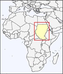
Sudan is the largest country in Africa and has a special geopolitical location bonding the Arab world to Africa south of the Sahara. It has an area of 2.5 million square kilometers (km2) extending between 4º and 22º North latitudes and 22° to 38° East longitudes. Its north-south extent is about 2,000 kilometers (km), while its maximum east-west extent is about 1,500 km. On the north-east it is bordered by the Red Sea and it shares common borders with nine countries: Eritrea and Ethiopia in the east, Kenya, Uganda, and the Democratic Republic of Congo in the south, The Central African Republic, Chad, and the Libyan Arab Jamahiriya in the west, and Egypt in the north. The country is a gently sloping plain with the exception of Jebel Marra, the Red Sea Hills, Nuba Mountains, and Imatong Hills. Its main features are the alluvial clay deposits in the central and eastern part, the stabilized sand dunes in the western and northern part and the red ironstone soils in the south. The soils of Sudan are broadly divided into six main categories according to their locations and manner of formation: i) desert; ii) semi-desert; iii) sand; iv) alkaline catena soil; v) alluvial soil; and vi) iron stone plateau. Within these soil categories there are many local variations with respect to drainage conditions.
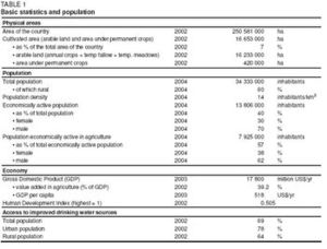
The cultivable area is estimated at about 105 million hectares (ha) (42 percent of the total land area), while in 2002 the cultivated land was 16.65 million ha (7 percent of the total land area and 16 percent of the cultivable area), comprising 16.23 million ha arable land and 0.42 million ha under permanent crops (Table 1). The forest resources of Sudan cover approximately 27 percent of the total country’s area. The main forest types include: i) arid shrubs and semi-arid shrubs; ii) low rainfall savanna; iii) high rainfall savanna; iv) special areas of mountainous vegetation in Jebel Marra, the Red Sea Hills, and the Imatong Mountains. Rangelands cover about 117 million ha. They spread over most ecological zones: the desert in the north, the semi-desert, the low rainfall savanna and the high rainfall woodlands in the south. Annual herbaceous plants with scattered trees and bushes dominate the northern rangelands. In the southern part, perennial herbaceous plants increase with dense stands of woody cover. The livestock population includes camels, sheep, and goats, which are raised in the desert and semi-desert, and cattle that are raised in the medium rainfall savanna and in the flood plain of the Upper Nile. Almost all livestock is raised under nomadic and semi-nomadic systems. The country has a diverse and fairly rich wildlife. Of the 13 African mammalian orders, 12 are present in Sudan. The protected wildlife areas cover around 36 million ha. There are 8 national parks, 13 game reserves, and 3 sanctuaries.
Sudan is under federal rule with 26 States. Each State is governed by a Wali (Governor) with 7 to 10 State Ministers, 4 to 5 Commissioners for the different provinces, and a number of localities. Each State has complete administrative and fiscal autonomy and its own State Legislative Assembly for legislative matters of the State.
Sudan has a tropical sub-continental climate, which is characterized by a wide range of variations extending from the desert climate in the north through a belt of summer-rain climate to an equatorial climate in the extreme south. The average annual rainfall is 416 millimeters (mm), but ranges between 25 mm in the dry north and over 1,600 mm in the tropical rain forests in the south. The country can be divided into three zones according to rainfall regime:
- The annual rainfall in the northern half of Sudan varies from 200 mm in the center of the country to 25 mm northwards towards the border with Egypt. Where it rains, the rainy season is limited to 2-3 months with the rest of the year virtually dry. Rainfall usually occurs in isolated showers, which vary considerably in duration, location, and from year to year. The coefficient of variation of the annual rainfall in this northern half of the country could be as high as 100 percent.
- In the quarter south of the center of the country, the annual rainfall barely exceeds 700 mm, and is concentrated in only four months, from July to October. The average annual rainfall of that region is between 300-500 mm. Rain-fed agriculture in Sudan is mainly practiced in this quarter. As the coefficient of variation in annual rainfall in this region is around 30 percent and the dry season extends for about eight months, the area cultivated and the productivity vary widely from one year to another.
- In the most southern quarter of the country, where the annual rainfall exceeds 700 mm and can go up to 1,600 mm, the area is dominated by extensive wetlands some parts of which are infested by insects which are hazardous to humans and livestock.
The mean temperature ranges from 30°C to 40 °C in summer and from 10 °C to 25 °C in winter. Potential annual evapotranspiration ranges from 3,000 mm in the north to 1,700 mm in the extreme south. Most of the agricultural activities are concentrated in the center of the country, in the generally semi-arid dry savanna zone, through which the Blue Nile and the Atbara River flow. The growing season in the region is around four months. The major limiting factor is not the agricultural potential, but the short duration of the rainy season and the erratic distribution of rainfall during the growing period.
Sudan’s population is 34.3 million (2004) with an annual growth rate of 2.2 percent (Table 1). Population density is 14 inhabitants/km2 and 60 percent of the total population is rural. Most of the population lives along the Nile and its tributaries, and some live around near points scattered around the country. At the national level, 69 percent of the population had access to improved drinking water sources in the year 2002. In urban areas this coverage was 78 percent, while in rural regions it was 64 percent (Table 1). Displaced families have increased the total population of villages, which has placed pressure on potable water resources.
The Human Development Index ranks Sudan in 139th place among 177 countries. Poverty in the Sudan is massive, deeply entrenched and predominantly a rural phenomenon. Over two-thirds of the population, and under the most favorable assumptions still around 50-70 percent, are estimated to live on less than US$1/day. In recognition of the severity of poverty in general, and of rural poverty in particular, the Government started to prepare a draft Poverty Reduction Strategy Paper (PRSP) and launched a pilot poverty-reduction program in 2001 to improve long-neglected rural social services. The program is financing basic education, primary health care, malaria prevention, and drinking-water supply.
Economy, Agriculture, and Food Security
Although endowed with rich natural resources, Sudan remains comparatively underdeveloped primarily as a result of protracted civil strife and poor economic management. The economy showed a limited response to reform packages during the 1980s and early 1990s. Budget deficits have been common, the average annual rate of inflation peaked at 70 percent for the period 1991-1995 but gradually subsided to less than 5 percent in 2001, then climbed to 8 percent in 2002. Interest rates remained negative during that period and resulted in the collapse of savings, affected the banking system adversely and eroded public confidence.
The Gross Domestic Product (GDP) of the Sudan was US$17.8 billion (current US$) in 2003. The agricultural sector is the most dominant in the country’s economy, even though its share has declined recently because of decreased agricultural production and the increased exploitation and export of mineral oil. In 2002, the sector contributed over 39 percent to the GDP and employed 57 percent of the total economically active population in 2004 (Table 1). It contributed about 90 percent of the Sudan’s non-oil export earnings.
Sudan’s agro-ecological zones support a variety of food, cash, and industrial crops. Vast natural pastures and forests support large herds of livestock including cattle, sheep, and goats. The main exported crops are cotton, Arabic gum, sesame, groundnuts, fruits, and vegetables; livestock is also important for exports. Within the agricultural sector, crop production accounts for 53 percent of agricultural output, livestock for 38 percent and forestry and fisheries for 9 percent.
Rainfed agriculture covers by far the largest area in Sudan. The area actually cultivated and total yield may, however, vary considerably from year to year depending on variability of rainfall. The rainfed farming system is characterized by a small farm size, labor-intensive cultivation techniques employing hand tools, low input level, and poor yields. Crops grown in the rainfed sector include sorghum, millet, sesame, sunflower, and groundnuts. According to the latest estimates, the traditional rainfed farming sector contributes all the production of millet, 11 percent of sorghum, 48 percent of groundnuts, and 28 percent of sesame production of the country. Mechanized rainfed agriculture comprises about 10,000 large farmers with farm sizes of 400-850 ha and a few large companies with holdings of 8,400-84,000 ha.
Sudan has the largest irrigated area in sub-Saharan Africa and the second largest in the whole of Africa, after Egypt. The irrigated sub-sector plays a very important role in the country’s agricultural production. Although the irrigated area constitutes only about 11 percent of the total cultivated land in Sudan, it contributes more than half of the total volume of the agricultural production. Irrigated agriculture has become more and more important over the past few decades as a result of drought and rainfall variability and uncertainty. It remains a central option to boost the economy in general and increase the living standard of the majority of the population.
Sudan is generally self-sufficient in basic foods, albeit with important inter-annual and geographical variations, and with wide regional and household disparities in food security prevailing across the country. The high-risk areas are North Kordofan, North Darfur, the Red Sea, Butana, and the fringes of the major irrigation schemes in addition to the Southern States. Major constraints to higher farm productivity and incomes are high marketing margins on agricultural produce and an inadequate allocation of budgetary resources and of the scarce foreign exchange earnings. As a result, the low input/low-productivity model of production continues to prevail, and small farmers’ incomes remain depressed. In the wake of the food shortages experienced in the 1980s, a high priority has been given by the Government to producing food crops. This has resulted in large expansions in sorghum and wheat areas and output. Much of this has been at the expense of the main cash crop, cotton, with production declining by more than 40 percent since the mid-1980s.
Water Resources and Use
Water Resources
Internally produced water resources in Sudan are rather limited. The erratic nature of the rainfall and its concentration in a short season places Sudan in a vulnerable situation, especially in rainfed areas. Surface water in Sudan comprises the Nile river system (nilotic water) and other, non-nilotic streams. 64 percent of the Nile Basin lies within Sudan, while 80 percent of Sudan lies in the Nile Basin. Local rainfall is the main source of the non-nilotic streams and of the Bahr El Ghazal basin, whereas rainfall over the Central African Plateau (Equatorial Lakes) and over the Ethiopian-Eritrean highlands is the main source of the Nile River system and other transboundary seasonal streams.
Sudan shares parts of the following basins with neighboring countries:
- The Nile Basin, 1,978,506 km2 (79.0 percent of the area of the country)
- The Northern Interior Basins, covering 313,365 km2 in the northwest part of the country (12.5 percent)
- The Lake Chad Basin, in the west of the country along the border with Chad and the Central African Republic, covering 101,048 km2 (4.0 percent)
- The Northeast Coast Basins, representing a strip along the Red Sea coast of the country, covering 96 450 km2 (3.8 percent)
- The Rift Valley Basin, in the southeast part of the country at the border with Ethiopia and Kenya, covering 16,441 km2 (0.7 percent)
The Nile system within Sudan comprises:
- The Blue Nile, Sobat, and Atbara Rivers originating in the [[Ethiopia]n] highlands
- The White Nile system, upstream of Sobat River, originating on the Lakes Plateau
- The Bahr El Ghazal Basin, an internal basin in southwest Sudan
The characteristics of the Nile system tributaries are the following:
- The Blue Nile: The flow of the Blue Nile reflects the seasonality of rainfall over the [[Ethiopia]n] highlands where the two flow periods are distinct. The flood period or wet season extends from July to October, with the maximum in August-September, and low flow or dry season from November to June. Therefore the annual Blue Nile hydrograph has a constant bell-shaped pattern, regardless of variation in the annual flow volumes. The average annual flow of the Blue Nile and its tributaries upstream of the confluence with the White Nile at Khartoum is about 50 cubic kilometers (km3); the daily flow fluctuates between 10 million m3 in April to 500 million m3 in August (ratio of 1:50).
- The White Nile: Due to losses in the Sudd swamp area, the White Nile leaves this area with only about 16 km3, out of 37 km3 on entering it. The river receives about 13 km3 from the Sobat River before joining the Blue Nile at Khartoum. The contribution of the Bahr el Ghazal basin is negligible, estimated at about 0.5 km3. The average annual flow of the White Nile System at Malakal is about 29.5 km3 and the daily discharge fluctuates between 50 million m3 in April to 110 million m3 in November (ratio 1:2). During the flood period the Blue Nile forms a natural dam that obstructs the flow of the White Nile and consequently floods the area upstream of the confluence.
- The Atbara River: This is a highly seasonal river, with an annual flow upstream of its confluence with the Nile of about 10 km3 restricted to the flood period of July-October, the maximum occurring between August-September. The river has a steep slope and small catchments, and reflects the rainfall over the upper catchments as runoff at Sudan's border within one to two days.
- The Main Nile: The reach of the Nile downstream of the confluence of the Blue Nile and the White Nile Rivers is known as the Main Nile. The Atbara River is regarded as the only and last tributary joining the Main Nile. The average annual flow of the Main Nile at the Sudan-Egypt border at Aswan is estimated at 84 km3.
The average annual yield of the non-nilotic streams is estimated at about 7 km3/yr, of which 5 km3/yr are internally produced. The major streams are the Gash and Baraka in the east of the country, both of which are characterized by large variations in annual flow and heavy silt loads.
|
Table 2. Water: sources and uses Renewable water resources Average precipitation 416 mm/yr 1,042 109 m3/yr Internal renewable water resources 30.0 109 m3/yr Total actual renewable water resources 64.5 109 m3/yr Dependency ratio 76.9 % Total actual renewable water resources per inhabitant 2004 1,879 m3/yr Total dam capacity 1995 8,730 106 m3 Water withdrawal Total water withdrawal 2000 37,314 106 m3/yr -irrigation + livestock 2000 36,069 106 m3/yr -domestic 2000 987 106 m3/yr -industry 2000 258 106 m3/yr -per inhabitant 2000 1,187 m3/yr -as% of total actual renewable water resources 2000 58 % Non-conventional sources of water Produced wastewater - 106 m3/yr Treated wastewater - 106 m3/yr Reused treated wastewater - 106 m3/yr Desalinated water produced 1990 0.4 106 m3/yr Reused agricultural drainage water - 106 m3/yr |
|---|
The major groundwater (Water profile of Sudan) formations and basins are the Nubian Sandstone Basin and the Umm Rwaba Basins. The Chazal, Sudd, and Sobat [[swamp]s] in the south of the country represent major wetlands, from which evaporation is exceptionally high. According to an estimate from 1980, the extent of the Sudd is over 16,200 km2, but the surface area fluctuates with rainfall. Sudan’s total natural renewable water resources are estimated to be 149 km3/yr, of which 30 km3/yr are internally produced (Table 2). In a 10th frequency dry year, the internal water resources are reduced to about 22.3 km3/yr. Of the internal water resources, 28 km3/yr are surface water and 7 km3/yr are groundwater, while the overlap between surface water and groundwater is estimated at 5 km3/yr. As a result of the Nile Waters Agreement with Egypt, total actual renewable water resources of the country amount to 64.5 km3/yr. The high variability of river flows necessitates storage facilities. The total storage capacity in the reservoirs of the following four main dams is estimated at 8.73 km3, reduced to about 6.90 km3 owing to sedimentation and debris:
- The Sennar Dam on the Blue Nile (design capacity 0.93 km3, present reservoir capacity 0.60 km3) is for the flood control and irrigation of the Gezira Scheme.
- The Roseires Dam on the Blue Nile (design capacity 3.0 km3, present reservoir capacity 2.2 km3; there are plans to increase the present dam height of 60 m to provide an extra capacity of 4.0 km3) is for flood control and utilizes part of the country’s share of the Nile waters for irrigation.
- The Jebel Aulia Dam on the White Nile (design capacity 3.5 km3, present reservoir capacity 3.5 km3) was originally designed to benefit Egypt by augmenting the supply of summer flow to the Aswan dam. After the construction of the High Aswan Dam it was no longer needed by Egypt and was officially handed over to the Sudan in 1977.
- The El Girba Dam on the Atbara River (design capacity 1.3 km3, present reservoir capacity 0.6 km3) is for flood control, irrigation of New Halfa Scheme for the benefit of the people displaced by the High Aswan Dam, and hydropower. A small barrage was constructed on the Rahad River to divert floodwater to the Rahad Agricultural Scheme and to siphon underneath the Dinder River to augment the water supply during the dry season from the Meina Pump Station on the Blue Nile. The Jonglei Canal, between Bahr el Jebel and the White Nile, was planned to divert water from upstream of the Sudd to a point farther down the White Nile, bypassing the [[swamp]s], to make more water available for use downstream. Works on it were discontinued in 1983 after two thirds were completed. Non-conventional water sources are limited in Sudan. However, the desalination of seawater was introduced recently in Port Sudan town. Fossil groundwater resources are estimated to be 16,000 km3.
Water Use
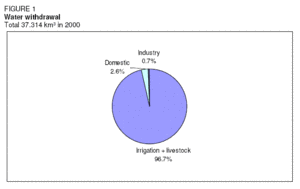
Total water withdrawal in the Sudan was estimated at 37 km3 for the year 2000 (Table 2). The largest water user by far was agriculture with 36 km3 (Figure 1). The domestic sector and industry accounted for withdrawals of 0.99 km3 and 0.26 km3 respectively. Water used in Sudan derives almost exclusively from surface water resources. Groundwater is used only in very limited areas, and mainly for domestic water supply.
International Water Issues
Surface water and groundwater resources are mostly shared with neighboring countries. The Nile River, which is shared between 10 countries, is the primary source of Sudan’s water. The four main non-nilotic streams are also shared with neighboring countries. The largest groundwater aquifer, the Nubian Sandstone system, is shared with Chad, the Libyan Arab Jamahiriya, and Egypt. The first Nile Waters Agreement between Egypt and Sudan was signed in 1929. It allocated to Egypt the right to use 48 km3/yr, while it gave Sudan the right to tap only about 4 km3/yr. The treaty does not allocate to Ethiopia any rights to use the Nile waters and also still binds Uganda, the United Republic of Tanzania, and Kenya and bars them from using the Lake Victoria waters. In 1959, the Nile Waters Agreement between Egypt and Sudan assigned to Sudan 18.5 km3/yr, measured at Aswan at the border with Egypt. The other riverside nations are still not included in this agreement. Recently, the Nile Basin Initiative has been created and prepared a Strategic Action Programme, which consists of two sub-programs: the Shared Vision Programme (SVP) and the Subsidiary Action Programme (SAP). The SVP is to help create an enabling environment for action on the ground through building trust and skill, while the SAP is aimed at the delivery of actual development projects involving two or more countries. Projects are selected by individual riparian countries for implementation and submitted to the Council of Ministers of the Nile Basin Initiative for approval. Sudan, Ethiopia, and Egypt have also adopted a strategy of cooperation in which all projects to be launched on the river should seek the common benefit of all member states and this should be included in accompanying feasibility studies. Sudan, together with Algeria, Cameroon, the Central African Republic, Chad, Niger, and Nigeria, is located in the Lake Chad basin.
Irrigation and Drainage Development
Evolution of Irrigation Development
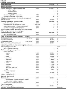
Irrigation potential was estimated at about 2.78 million ha based on soil and water resources criteria. This figure does not take into account possible large-scale developments in the enormous wetlands in southern Sudan. Large-scale gravity irrigation started during the British colonial period (1898-1956) and the colonial agricultural policy was characterized by the promotion of cotton production in the Nile Basin. Irrigation by pumping water began at the beginning of the 20th Century, substituting traditional flood irrigation and water wheel techniques. The Gezira Scheme is Sudan’s oldest and largest gravity irrigation system, located between the Blue Nile and the White Nile. Started in 1925 and progressively expanded thereafter, it covers about 880,000 ha. It receives water from the Sennar Dam on the Blue Nile and is divided into some 114,000 tenancies. Farmers operate the scheme in partnership with the government and the Sudan Gezira Board, which provides administration, credit, and marketing services. The scheme has played an important role in the economic development of Sudan, serving as a major source of foreign exchange earnings and of Government revenue. It has also contributed to national food security and in generating a livelihood for the 2.7 million people who now live in the command area of the scheme.
| Table 4. Government Irrigation schemes in Sudan | |
| Scheme | Equipped area (ha) |
| Geizira and Managil | 870,750 |
| White Nile pump schemes | 192,375 |
| New Halfa | 152,280 |
| Rahad | 121,500 |
| Blue Nile pump schemes | 112,590 |
| Gash Delta (spate irrigation) | 101,250 |
| Northern pump scheme | 41,715 |
| Suki | 35,235 |
| Tokar Delta (spate irrigation) | 30,780 |
| Guneid Sugar | 15,795 |
| Assalaya Sugar | 14,175 |
| Sennar Sugar | 12,960 |
| Khashm El Girba | 18,225 |
| Other areas | 143,370 |
| Total | 1,863,000 |
In the post-colonial period, it was assumed that the only sound way to bring about development would still be through large irrigation developments. The increase in Nile water allocation through the 1959 Nile Waters Agreement with Egypt led for example to the construction of the Managil extension of the Gezira Scheme and of the New Halfa Scheme. The New Halfa Scheme is located on the upper Atbara River in the east of the country. It was partly financed by Egypt after the construction of the Aswan High Dam that created Lake Nasser, which flooded the Sudanese town of Wadi Halfa in 1964. Since then the inhabitants have been moved to the new irrigated agricultural lands where they have been growing a variety of crops. In the 1970s, Sudan was expected to become the "bread basket" of the Arab world, and with large investments from oil-rich Gulf nations, irrigation schemes such as the Rahad Scheme, which receives its water from the Rahad River and the Blue Nile, were established. Large-scale irrigated agriculture expanded from 1.17 million ha in 1956 to more than 1.68 million ha by 1977. The 1980s were a period of rehabilitation, with efforts to improve the performance of the irrigation sub-sector. In the 1990s, some smaller schemes were licensed to the private sector, while the four big schemes of Gezira and Managil, New Halfa, and Rahad remained under government control because they were considered strategic schemes.
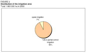
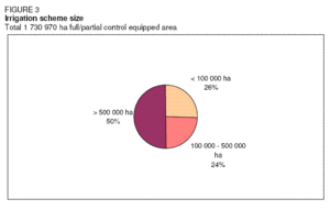
In 2000, the total area equipped for irrigation was 1,863,000 ha, comprising 1,730,970 ha equipped for full or partial control irrigation and 132,030 ha equipped for spate irrigation (Table 3, Table 4 and Figure 2). Only about 800,000 ha, or 43 percent of the total area, are actually irrigated owing to deterioration of the irrigation and drainage infrastructures. In 1995, surface water was the water source for 96 percent of the total irrigated area land, and the remaining 4 percent were irrigated from groundwater (small tube-wells). The irrigated area where pumps are used to lift water was 346,680 ha in 2000. Most irrigation schemes are large-scale and they are managed by parastatal organizations known as Agricultural Corporations, while small-scale schemes are owned and operated by individuals or cooperatives (Figure 3).
A number of water harvesting projects were implemented in the western part of Sudan during the 1970s, 1980s, and late 1990s. The main objective was to combat the effects of drought by improving crop production and increasing domestic water use. However, few of those projects have succeeded in combining technical efficiency with low cost and acceptability to the local agro-pastoralist farmers. This is partially owing to the lack of technical know-how, but also because of the selection of inappropriate approaches with regard to the prevailing socio-economic conditions.
Role of Irrigation in Agricultural Production, the Economy, and Society
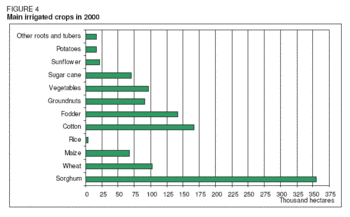
The main irrigated crops are sorghum, cotton, fodder, wheat, groundnuts, and vegetables (Table 3 and Figure 4). Other crops under irrigation are sugar cane, maize, sunflower, potatoes, roots, and tubers and rice. Irrigated agriculture has been Sudan’s largest economic investment, yet returns have been far below potential. A study by the World Bank showed that, during the period 1976-1989, yields were low and extremely variable and cultivated areas suffered a gradual decline. A study undertaken in the Rahad Scheme based on data from 1977 to 1995 shows that actual crop yields are well below potential yields (Table 5). The same study also estimated the water use efficiency and found an overall efficiency of 63-68 percent. The distribution efficiency of the network was 93 percent and estimated field losses were 25-30 percent. In the Gezira Scheme, a complex mix of financial, technical, and institutional problems resulted in a serious fall in the productivity of the scheme and a corresponding drop in farm incomes in the late 1990s, resulting in a drop of cropping intensity from 80 percent in 1991/1992 to 40 percent in 1998/1999. About 126,000 ha were taken out of production owing to siltation and water mismanagement, leading to a reduced availability of water. Because of bad water management, water supply is about 12 percent below crop water requirements at crucial stages in the growth cycle, while at the same time, as much as 30 percent of the water delivered is not used by crops. However, an initiative aimed at "Broadening farmer’s choices on farm systems and water management" by Food and Agriculture Organization (FAO) in part of the scheme, meant that productivity of sorghum, cotton, and wheat could be increased to 112 percent for 2000/2001, compared to the Gezira average of 42 percent.
Apart from the Gezira scheme established in 1925, most of the irrigation schemes were developed in the 1960s and 1970s. Since then, there have been no significant irrigation developments, for two reasons: any possible remaining sites would be complex and expensive to develop, and the low levels of productivity of the irrigated crops in the country make it difficult to justify further investment. As a result, in order to meet an ever-increasing demand for food and fiber, priority has been given to increasing productivity from the existing irrigation schemes. But this objective has been thwarted by the declining supply of water to farmers in these schemes. Consequently, the performance of the irrigation sector has consistently fallen short of expectations. (Water profile of Sudan)
Status and Evolution of Drainage Systems
Due to excess rainfall and sometimes to misuse of irrigation water all the irrigation schemes need drainage networks to remove any excess water from the cultivated areas. In low areas, minor drains, and collector drains are constructed to remove this excess water by gravity into cutout low areas or into natural drains. Sometimes, pumps are used to take water from low lands into areas outside the scheme. Also escape drains are constructed along the main canal to carry any excess water to the nearest river or natural drain. It is estimated that in 2000 about 560,000 ha were drained.
Water Management, Policies, and Legislation Related to Water Use in Agriculture
Institutions
The Ministry of Agriculture and Natural Resources (MANR) supervises the Agricultural Corporations that manage the large irrigation schemes, while the Ministry of Irrigation and Water Resources (MIWR) is responsible for delivering irrigation water. The Ministry of Irrigation and Water Resources (MIWR) is the federal body in Sudan legally responsible for all water affairs. It offers technical advice and assistance to water projects within the states and the private sector. It is in charge of the groundwater, the non-nilotic streams, and valleys under the Groundwater and Wadis Directorate. It undertakes its task in coordination with the relevant sectors, departments, and technical offices (agriculture, industry, foreign, electricity, and investment, etc). It has the following responsibilities:
- Satisfaction of the water requirements of the various users through the country
- Water resources planning, management, and development
- International and regional cooperation concerning the shared water sources
- Planning, design, execution, operation, and maintenance of the different irrigation schemes
- Control of water abstraction
- Construction of new irrigation works
- Operation and maintenance of all large-scale irrigation structures and drinking water facilities
- Provision of the means for hydropower generation and protection of the water-related environment.
Water Management
The Gezira Scheme is managed on a vertically integrated basis by the semi-autonomous Sudan Gezira Board (SGB). The MIWR is responsible for managing the Sennar Dam on the Blue Nile and the upper reaches of the irrigation system, responding to requests for water delivery from SGB’s field staff. Within the scheme, the SGB serves as landlord, operates, and maintains the lower reaches of the irrigation system and provides most of the inputs and services required by farmers to produce cotton, which is transported by the Board to its ginneries and sold on behalf of growers by the Sudan Cotton Company Limited. The SGB recovers the cost of advances made for inputs and services from the cotton sales before payment is made to the farmer. Tenants are wholly responsible for growing other crops in prescribed rotations with cotton (sorghum, groundnuts, forage, wheat, vegetables), making their own arrangements for input supplies and marketing. By 2001 in the Gezira Scheme, Minor Canal Committees had been formed along the minor irrigation canals and representatives of each of these committees constitute the Irrigation Committee at the block level. In addition to the Irrigation Committee, a Financial Committee has been established that is coordinating the reimbursement of the seasonal credits, and arrangements for procurement of new inputs. The Irrigation Committee with representatives of each of the minor canal committees will be responsible for the operation and maintenance of the minor irrigation system, a task presently entrusted to the SGB, with the Ministry of Irrigation responsible of supplying the main system. To address some of the problems facing irrigation management and development the Government has formalized a policy framework that includes:
- Transferring the operation and production of large- and medium-size irrigation schemes to the farmers and giving them full responsibility for water management on the irrigation system below the minor canals level through establishment of voluntary water users associations (WUAs).
- Fostering sustainable productivity of the large schemes through rehabilitation, combined with financial, and institutional reform.
- Grouping, rehabilitating, and handing over the relatively small size pump schemes in the Blue Nile and the White Nile. These schemes were originally established and run by the government. Recently, and in accordance with the economic reforms, these schemes were handed over to the private sector represented by individual farmers, cooperatives, or private companies.
Finances
Financing irrigation operations and maintenance (O&M) through fees collected from the beneficiaries of the irrigation system was first introduced in Sudan with the introduction of the modern irrigation system at the El Zeidab scheme in 1909 when a private foreign company erected a pump station to irrigate local farmers’ land for an agreed irrigation fee. After the success of the experiment for the first two seasons, a bad crop yield in 1911/1912 meant that the farmers were unable to pay their irrigation fees. The company experienced heavy losses and decided to pull out of the scheme. Experience from El Zeidab scheme was used in selecting the form of production relationship between the government, the Sudan Plantation Syndicate, and the farmers when the Gezira scheme was commissioned. To avoid the inability of some farmers to pay irrigation fees in case of bad crop yields, a "sharing system" between the three parties was adopted. This system continued until 1981 when it was replaced by what is known as the "individual account system" in which each individual farmer is treated separately in terms of cost and profit. The objective was to create some incentive for the individual farmers to increase their productivity. The new account system failed to achieve break-even productivity. The individual account system was also applied in all the irrigation schemes run by the government at that time. Payment of irrigation fees by the farmers continued in all Government schemes from 1981 to 1995. During this period irrigation fees collected were very low, averaging about 50 percent only. The non-recovered part of the water supply costs is borne by the government. Starting from 1995, and as part of the liberalization of the economy, the Government withdrew from financing the cost of irrigation services, among other things. Farmers were left to pay irrigation fees to the newly established Irrigation Water Corporation (IWC), which uses these fees directly to provide water supply services to the farmers. Instead of the IWC setting up its own mechanism for collecting the fees directly from the farmers, it relies on the Agricultural Corporations (AC) managing the scheme to collect the fees from the farmers. Because these ACs were also facing considerable financial difficulties, part of the water fees collected may not reach the IWC and part of the collected fees paid to IWC is delayed for sometime as it is used for financing other urgent activities. The result of this is the inability of IWC to have the required budget that enables it to provide its services in a sustainable manner. This led to the accumulation of sediment in the irrigation canals, deterioration of the water regulation structures, machinery, and pumps. By the year 2000 the IWC was dissolved and the MIWR is again responsible for the O&M of the irrigation canals up to the minor off-takes. The Ministry of Finance and National Economy provides the MIWR with the annual budgets for operation and maintenance.
Policies and Legislation
In 1992, the national economy was reoriented towards a free economy, a policy shift that impacted the agricultural sector profoundly. The government withdrew from the direct financing of agriculture, provision of inputs and services. The Government within its policy of withdrawal from provision of goods and services handed over all the small- and medium-size irrigation schemes under its control to the farmers. The handing over policy was not successful because farmers were ill-prepared and most of the schemes were in need of rehabilitation. Since 1992, the cropped areas and the productivity of many schemes have sharply declined. Agricultural sectoral policies for the irrigated sub-sector include the following:
- To extend the market economy to all crops to allow the farmer to choose a suitable crop mix.
- To provide support to the Agricultural Research Institutions so as to explore suitable technologies for improving crop production and productivity. In addition, to provide support to agricultural extension and services.
- To encourage the private sector to provide agricultural inputs for the agricultural sector.
- To encourage exports through improvement of quality so as to meet international standards.
- Establishment of specialized crop committees for main crops like cotton with the objective of achieving all necessary coordination between the concerned authorities.
- Farmers participate in agricultural policy formulation. The Sudan Comprehensive National Strategy for the Agricultural Sector (1992-2002) put food security, sustained agricultural development, efficient resource utilization, and yield enhancement on the top of the agenda. Little has been done, however, to improve the accessibility to food of the poor, the vulnerable, and the marginalized strata of society.
Environment and Health
The deposition of silt in irrigation canals and the subsequent built-up of aquatic weeds result in losses in production of up to 40 percent. Other costs of siltation include loss of hydropower potential since methods of silt removal involve measures that lower the head and interfere with generator operation. The most serious effect, however, is the loss of agricultural production. Agricultural chemicals were introduced into Sudan in 1946 in the Gezira scheme. Since then the application of chemicals has intensified and proliferated into other [[agricultural] schemes] and in the private vegetable and horticulture fields as well as for control of desert locusts, birds, and rodents and for public health. A total of about 200 active ingredients are registered in Sudan in over 600 different formulations of pesticides. An average of about 450 tonnes of insecticides and 150 tonnes of herbicides were applied annually during the period 1993-1997. The annual consumption of fertilizers in the whole of Sudan is estimated at 80,000-200,000 tonnes of urea and 20,000-40,000 tonnes of super phosphate. The applied pesticides or the residue and degradation products can contaminate the water resources from the formulating sites, fallout from the spray, washing from contaminated clothes, empty containers, application equipment, and dumping of the surplus. Serious contamination has been detected in the Gezira canals as well as in boreholes in the Qurashi area (Hassahessa Province) and the Kassala horticulture area. Fertilizers containing inorganic nitrogen as well as waste containing organic nitrogen are the two main sources of frequently reported nitrate and nitrite contamination in groundwater. Detailed studies are needed to discriminate between the two pollution sources.
Perspectives for Agricultural Water Management
The country has an agricultural potential of 105 million ha, of which only 16.7 million ha are cultivated and only about 1.9 million ha out of an irrigation potential of 2.8 million ha are under irrigation now. Therefore, there is ample room for further developments especially in the irrigation sub-sector. However, there are three major constraints to irrigation development in Sudan:
- The ineffective process of annual maintenance of civil works (reportedly due to lack of funds), especially for the removal of silt and weeds from irrigation canals, which slows down water flow and causes continuous shrinkage of the actual irrigated area
- The steady increase in development costs, which has been aggravated by the continuous devaluation of the local currency
- The lack of farmer involvement in the planning and operation of the schemes and related services Generally, the water supply for all of the irrigation schemes is provided by dams and/or pumps and extensive networks of canals covering the whole schemes as well as drainage networks of canals.
The overall objective of water management policies is to improve water use efficiency in agriculture, which includes efficient control of water in the irrigation networks, maintenance of the irrigation structures, provision of technical capacities capable to operate the systems, and efficient, and economical maintenance of the irrigation systems. Supplementary irrigation could increase the very low or zero productivity of crops and fodder. The conjunctive use of groundwater and surface water could help to optimize the water resource productivity. The development plans for the irrigation sector include the rehabilitation of the existing irrigation schemes, a shift of emphasis towards the development of small scale irrigation schemes, and phased development and vertical expansion.
Further Reading
- Abdelsalam, A. 1991. Sedimentation in Sudan Multipurpose Reservoirs. Internal Publ. Hydraulic Research Station-Sudan.
- Adam, H. S. 1994. Evaporation: how difficult to measure and estimate. Nile 2002 Conference, Khartoum, Sudan.
- Bakheit, H. Y. 1996. Hydromet data. 4th Nile 2002 conference, Kampala, Uganda.
- Dafalla, Y. M. 1996. Reliability of rainfall for crop production in the Sudan. IVth Nile 2002 Conference, Kampala, Uganda.
- El-Farouk, A. E. 1994. Population and environmental degradation in the Sudanese agriculture and forestry. Nile 2002 conference, Khartoum, Sudan.
- Elmahadi E. 2000. The Nile Water Elaharam. Cairo, Egypt.
- FAO. 1994. Water harvesting for improved agricultural production. Water Report 3. Rome. ISBN: 9251035962
- FAO. 1997. Irrigation potential in Africa: A basin approach. FAO Land and Water Bulletin 4. Rome.
- FAO. 2000. Water and agriculture in the Nile Basin. Nile Basin Initiative Report to ICCON. Background paper prepared by FAO. Report prepared by Appelgren, B., Klohn. W. and Alam, U. Rome.
- Ghezae, N. 1998. Irrigation water management: a performance study of the Rahad Scheme in Sudan, 1977-1996. Acta Universitatis Upsaliensis. Uppsala Studies in Economic History 42. ISBN: 9155441939
- Hamad, O. E., El Daw, A. K. and Dingle, M. A. 2002. Development of water resources research as a base for development. Workshop on the future of scientific research in the field of water (Arabic). Khartoum, Sudan.
- Ibrahim, M. E. and Salih, M. K. 1996. Groundwater resources of Sudan: development potential. IVth Nile 2002 Conference, Kampala, Uganda.
- International Fund for Agricultural Development (IFAD). 2002. Republic of the Sudan. Country strategic opportunities paper (COSOP). Rome.
- International Fund for Agricultural Development (IFAD). 2003. Gash sustainable livelihoods regeneration project. Target group and project description. Prepared by Near East and North Africa Division, Project Management Department.
- International Hydrologic Programme (IHP). 2000. Vulnerability of groundwater resources of Sudan to pollution risks. Technical Report. IHP-National Chair of the Sudanese National Commission for Education, Science and Culture. Khartoum.
- International Programme for Technology and Research in Irrigation and Drainage (IPTRID). 2002. Capacity Building for drainage in North Africa. Proceeding of a workshop, Cairo, Egypt, 10-14 March 2001. In: Capacity Building Report No.2. Rome.
- Ministry of Irrigation and Water Resources. 2001. Feasibility study of the White Nile pump schemes irrigation rehabilitation project. Internal report.
- Saghyroun, E. S. 1994. The Nile Water: the past, present and future International conference on efficient utilization and management of water resources in Africa. Khartoum, Sudan.