Waquoit Bay National Estuarine Research Reserve, Massachusetts
Contents
Introduction
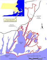
The Waquoit Bay National Estuarine Research Reserve (WBNERR) is located on the south shore of Cape Cod, Massachusetts in the towns of Falmouth and Mashpee. It encompasses some 3,000 acres of open waters, barrier beaches, marshlands and uplands. Land components include Washburn Island, South Cape Beach State Park, property surrounding the Quashnet River and Reserve Headquarters. The Waquoit Bay NERR is part of the National Estuarine Research Reserve System (Waquoit Bay National Estuarine Research Reserve, Massachusetts) , which presently includes 25 sites in 20 states, and Puerto Rico. Each site represents a different coastal region. The Waquoit Bay Reserve is representative of the Northern Virginian biogeographic region, from Chesapeake Bay to Cape Cod. WBNERR is co-funded and co-managed by the National Oceanic and Atmospheric Administration's Office of Ocean and Coastal Resource Management, Estuarine Reserves Division and by the Massachusetts Department of Conservation and Recreation.
Site Description
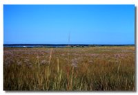
Habitats at Waquoit Bay Reserve include salt ponds, salt marshes, eelgrass meadows, barrier beaches/dunes, open water, pine and oak forests and sandplain grasslands.
Plants: Floral communities include pine and oak forests, sandplain grasslands, saltmarsh and eelgrass meadows. Recently macroalgae (seaweed) has been replacing eelgrass meadows in Waquoit Bay.
Animals: Waquoit Bay provides food, shelter, spawning and nursery grounds for numerous fish and shell fish species. About 30 species commercially harvested spend part of their lives in or visit Waquoit Bay estuarine waters. Of note are eel, flounder, trout, herring, bluefish, striped bass, scallops, clams and blue crabs. Fox, deer, raccoons as well as owls, ospreys, herons (Great Blue, Night Crowned, Green), Canada Goose, Mute Swans and several ducks are found in the Reserve.
Endangered Species
The reserve is home to several protected species, including the Federally Endangered Sandplain Gerardia. Other protected floral species include Bushy Rockrose, Thread-Leaved Sundew, Northern Blazing Star, Butterfly-weed, Little Ladies Tresses, Eastern Lilaeopsis, Vetchling, Narrow-Leaved Wild Rice and Knotroot Foxtail. The population of Northern Blazing Star on Washburn Island is the largest in the state of Massachusetts.
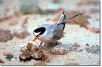
The Piping Plover is a federally threatened species that nests on South Cape Beach and Washburn Island. For many years predators and human impacts interfered with successful hatching. In 1990, the reserve started the volunteer Piping Plover Patrol. In cooperation with the Massachusetts Department of Fisheries and Wildlife and Massachusetts Audubon, the reserve trains volunteers to identify signs of mating and nesting. When eggs are laid, volunteers erect predator exclusion fences according to instructions. Since the inception of the patrol, there have been several successful hatchings. Each year more birds return to nest; they have now expanded their nesting territory to Washburn Island. The Endangered Shorebird Monitor, a seasonal position hired through the Massachusetts Department of Environmental Management now coordinates that program with oversight by the reserve.
Federally endangered Roseate Terns fish for sand lance on the shoals of Nantucket Sound off South Cape Beach. The barrier beach provides an important resting and staging area for their feeding activity.
The Least Tern, a state species of special concern, also nests on South Cape and is protected by the Piping Plover Patrol.
The Box Turtle is another species of state concern that is found on South Cape Beach and the reserve headquarters.
Tidal Range and River Flow
The morphology of Waquoit Bay is like that of other New England coastal bays, which typically feature asymmetric-shaped bays, fringing marshes, fronting barrier spits or beaches and inlets. The amount of water that enters and exits the bay is determined by the magnitude of the tides as well as by the morphology of the Bay and its inlets. Tidal range of Waquoit bay is about 0.6 meters.
As a Cape Cod embayment, Waquoit Bay is unusual in that it is fed by two sizable rivers - the Childs and Quashnet - entering Eel Pond and Waquoit Bay, respectively. Fifty percent of the freshwater entering Waquoit Bay comes from these rivers. Groundwater is another major contributor of freshwater to Waquoit Bay. The rivers themselves are groundwater-fed; groundwater enters the rivers through the sediments and through springs in embankments along the floodplain.
Soil Types
Because Cape Cod is so young, the glacial materials have not been significantly altered. The result is a sandy porous soil with weakly developed soil horizons. The parent materials for most of the Mashpee outwash plain soils are the sands and gravels mixed with some pebbles and small boulder gravel that were deposited by meltwater streams. Clay and silt lenses generally are found in deeper sediments to the south. The porous soils support rapid percolation of rain, nutrients and contaminants into the subsoil and eventually to the groundwater, a feature that has many ramifications for watershed protection issues.
The rapid leaching of moisture and nutrients from the top soil horizons forms the podzolic soils commonly found in the Waquoit Bay region. Cape Cod's podzolic soils are only a few inches to several feet thick and generally do not support a rich flora and fauna. These soils are highly acidic in nature, and are classified as dry, coarse, sandy soils with slopes of less than 15 percent.
Other soils found in the coastal areas of the reserve include the saltmarsh soils subjected to regular tidal flooding and the muck deposits found in surface depressions where the water table generally is at or near the surface. Beach materials that form the bars and spits off the South Cape Beach and Washburn Island barrier beach complex are composed primarily of sand, but contain some cobbles and pebbles as well. Dune materials, composed of quartose sands, rounded by wind and wave action are very young (between 10 and several hundred years old) and are generally less than 20 feet thick.
Geology
Waquoit Bay watershed, like all of Cape Cod, is a geologically young landform composed of glacial materials deposited on top of bedrock toward the end of the Wisconsinan Glacial Stage about 12,000 years ago. The Waquoit Bay watershed lies entirely within the Mashpee pitted outwash plain. Outwash plains were created by broad meltwater streams emanating from the melting glacier margins that carried sands and gravels that were once embedded within the glacial mass. The flowing meltwater streams size-sorted the drift materials depositing the heavier boulders and pebbles near the glacial margin and gravels and sands further away. The term "pitted" refers to the numerous kettle ponds dotting the landscape. Johns Pond and Ashumet Pond are two examples of kettle ponds in the watershed. Waquoit Bay, itself, may have originated as a kettle pond whose southern margin was flooded by sea-level rise.
At the close of the Wisconsinan Glacial Stage, the ice sheet retreated and sea level began to rise inundating low-lying coastal areas. The action of [[wind]s], waves and currents eroded and displaced the loose glacial sand and gravel contributing to the formation of coastal sand dunes, sea cliffs, barrier beaches and salt marshes. These processes continue to alter the dynamic shore.
Waquoit Bay's hydrology is controlled by the region's geology, which is typical of a glacial outwash plain. The unconsolidated sediments of Cape Cod make ideal aquifers. In recognition of the unique groundwater characteristics of Cape Cod, the U.S. Environmental Protection Agency declared this region a Sole-Source Aquifer in 1982, a designation designed to facilitate protection of the water supply. In actuality, the Cape Cod aquifer can be subdivided into six groundwater lenses; the Waquoit Bay watershed lies within the Sagamore or western Cape lens of the Cape Cod Aquifer.
Cultural History
Land and water areas within the reserve were presumably hunting and fishing areas for Native Americans. Stone flakes attesting to that use have been recovered from Washburn Island. The scarcity of artifacts may be the result of inundation of low-lying areas by sea-level rise. According to the Mashpee Wampanoags, the People of the First Light, their people have been in this area "since time."
European settlers fished and farmed, and their descendants later built mills and cranberry bogs. In the early 1900s, summer communities began along the coast. In recent years, the area has seen large growth in the year-round population; the summer season brings numerous additional visitors.
Research
Research at the reserve focuses on a variety of issues that are important to the Cape Cod area. Particular attention is paid to non-point source pollution as population growth along the coast has increased the amount of nitrogen entering coastal waters. To address this issue as well as many others, reserve scientists collaborate with many outside biologists, chemists, geologists and hydrologists from a variety of institutions, including the Marine Biological Laboratory and the Woods Hole Oceanographic Institution.
Partners and Supporters
The reserve is managed in partnership by the National Oceanic and Atmospheric Administration and the Massachusetts Department of Conservation and Recreation. Citizens for the Protection of Waquoit Bay, the reserve's official friends group, and more than 100 volunteers aid the reserve in its mission of coastal stewardship, research and education. Reserve staff serve on many community, regional and state standing committees and form partnerships to formulate and implement solutions for specific problems.
Further Reading
| Disclaimer: This article is taken wholly from, or contains information that was originally published by, the National Oceanic and Atmospheric Administration. Topic editors and authors for the Encyclopedia of Earth may have edited its content or added new information. The use of information from the National Oceanic and Atmospheric Administration should not be construed as support for or endorsement by that organization for any new information added by EoE personnel, or for any editing of the original content. |