Turkmenistan (About the EoE)
Contents
Turkmenistan
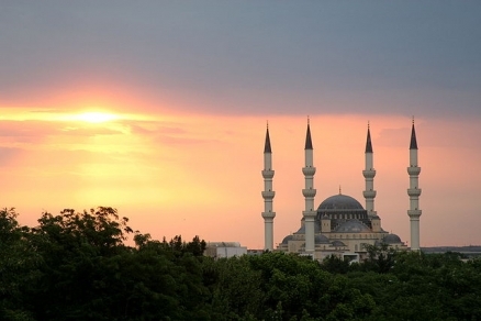
Ertugrul Gazi Mosque in Ashgabat. Source: Jim Fitzgerald/Wikimedia Commons
Countries and Regions of the World Collection  Turkmenistan is a landlocked nation of five million people in central Asia, bordering the Caspian Sea, between Iran and Kazakhstan.
The western and central low-lying desolate portions of the country make up the great Garagum (Kara-Kum) desert, which occupies over 80% of the country. The eastern part is plateau.
Its major environmental issues include:
- contamination of soil and groundwater with agricultural chemicals, pesticides;
- salination, water logging of soil due to poor irrigation methods;
- Caspian Sea pollution;
- diversion of a large share of the flow of the Amu Darya into irrigation contributes to that river's inability to replenish the Aral Sea; and,
- desertification
|
|
|
|


Eastern Turkmenistan for centuries formed part of the Persian province of Khurasan. In medieval times Merv (today known as Mary) was one of the great cities of the Islamic world and an important stop on the Silk Road.
Annexed by Russia between 1865 and 1885, Turkmenistan became a Soviet republic in 1924.
It achieved independence upon the dissolution of the USSR in 1991.
Extensive hydrocarbon/natural gas reserves could prove a boon to this underdeveloped country once extraction and delivery projects are expanded. The Turkmen Government is actively working to diversify its gas export routes beyond the still dominant Russian pipeline network. In 2010, new gas export pipelines that carry Turkmen gas to China and to northern Iran began operating, effectively ending the Russian monopoly on Turkmen gas exports.
President for Life Saparmurat Nyyazow died in December 2006, and Turkmenistan held its first multi-candidate presidential election in February 2007. Gurbanguly Berdimuhamedow, a deputy cabinet chairman under Nyyazow, emerged as the country's new president; he was reelected in February 2012.
Turkmenistan is largely a desert country with intensive agriculture in irrigated oases and sizeable gas and oil resources.
Geography
Location: entral Asia, bordering the Caspian Sea, between Iran and Kazakhstan
Geographic Coordinates: 40 00 N, 60 00 E
Area: 488,100 sq km (land: 469,930 sq km; water: 18,170 sq km)
Land Boundaries: 3,736 km (Afghanistan 744 km, Iran 992 km, Kazakhstan 379 km, Uzbekistan 1,621 km)
Coastline: 0 km; note - Turkmenistan borders the Caspian Sea (1,768 km)
Terrain: flat-to-rolling sandy desert with dunes rising to mountains in the south; low mountains along border with Iran; borders Caspian Sea in west. The highest point is Gora Ayribaba (3,139 m) and the lowest point Vpadina Akchanaya (-81 m) . Note: Sarygamysh Koli is a lake in northern Turkmenistan with a water level that fluctuates above and below the elevation of Vpadina Akchanaya (the lake has dropped as low as -110 m).
Climate: subtropical desert

Source: Wikimedia Commons
Ecology and Biodiversity
Source: World Wildlife Fund
- Central Asian southern desert
- Caspian lowland desert
- Central Asian riparian woodlands
- Kopet Dag semi-desert
- Kopet Dag woodlands and forest steppe
- Badkhiz-Karabil semi-desert
- Alai-Western Tian Shan steppe
See also:
International Environmental Agreements
Turkmenistan is party to international agreements on: Biodiversity, Climate Change, Climate Change-Kyoto Protocol, Desertification, Hazardous Wastes, and Ozone Layer Protection.
|
|
|
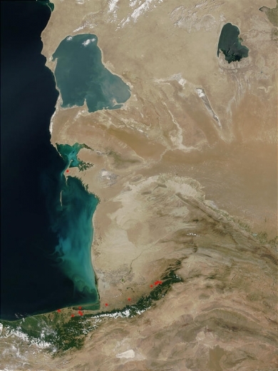
A surprising stretch of green vegetation in otherwise pale, arid terrain, the Elburz Mountains (bottom center) in northern Iran capture the majority of the moisture coming from the Caspian Sea (image left). Several scattered fires (red dots) have been detected by the Moderate Resolution Imaging Spectroradiometer (MODIS) in this image from June 24, 2002. Along the shores of Turkmenistan, the Caspian Sea is swirling with blues and greens, which may be a mixture of sediment and microscopic marine plants called phytoplankton. In interior Turkmenistan, (left center) the vast Karakum Desert covers almost 80 percent of the country. Source: NASA. Credit: Jacques Descloitres, MODIS Land Rapid Response Team, NASA/GSFC |
|
|
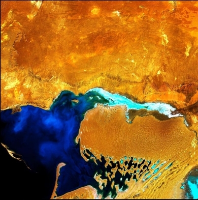
| Looking like a monstrous ogre with something gooey in its mouth, this enhanced satellite image shows the Dardzha Peninsula in western Turkmenistan, which lies among the shallow coastal terraces of the Caspian Sea. Strong winds create huge sand dunes near the water, some of which are partly submerged. Further inland, the dunes transition to low sand plains. Image courtesy of USGS. |
|
|
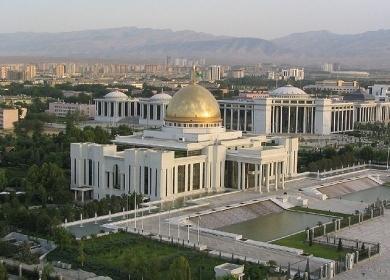
| Presidential Palace in Ashgabat. Source: Wikimedia Commons. |
People and Society
Population: 5,054,828 (July 2012 est.)
The majority of Turkmenistan's citizens are ethnic Turkmen; other ethnic groups include Russian, Uzbek, and Kazakh. Turkmen is the official language of Turkmenistan, though Russian still is widely spoken as a "language of inter-ethnic communication" (per the 1992 constitution). Education is universal and mandatory through the secondary level, the total duration of which is 10 years.
The population is 89% Sunni Muslim. The constitution provides for freedom of religion and does not establish a state religion; however, in practice, the government continues to monitor all forms of religious expression. Amendments to the law on religious organizations adopted in March 2004 reduced membership requirements from 500 to 5 for registration purposes. All groups must register in order to gain legal status with the government. Until 2004 the only religions that were registered successfully were Sunni Islam and Russian Orthodox Christianity. As of August 2010, 11 other religious groups were registered. The government limits the activities of unregistered religious congregations by prohibiting them from gathering publicly, proselytizing, and disseminating religious materials.
The government has started to review and rewrite its legislation with the stated goal of meeting international standards, including the criminal and criminal procedures codes and laws on religion and assembly. In late September 2008, a revised national constitution was adopted. It included provisions for a strengthened and enlarged Mejlis (parliament), eliminated many of former President Niyazov's arbitrary addenda, and contained some rights-related textual changes the international community had suggested. Most notably, it eliminated the Halk Maslahaty (Peoples Council), an oversized, bureaucratic, and largely rubber-stamp body whose powers have largely been transferred to the Mejlis.
Ethnic Groups: Turkmen 85%, Uzbek 5%, Russian 4%, other 6% (2003)
Age Structure:
0-14 years: 27.5% (male 696,749/female 679,936)
15-64 years: 68.4% (male 1,692,885/female 1,724,019)
65 years and over: 4.1% (male 88,590/female 115,324) (2011 est.)
Population Growth Rate: 1.143% (2012 est.)
Birthrate: 19.55 births/1,000 population (2012 est.)
Death Rate: 6.21 deaths/1,000 population (July 2012 est.)
Net Migration Rate: -1.9 migrant(s)/1,000 population (2012 est.)
Life Expectancy at Birth: 68.84 years
male: 65.87 years
female: 71.96 years (2012 est.)
Total Fertility Rate: 2.16 children born/woman (2011 est.)
Languages: Turkmen (official) 72%, Russian 12%, Uzbek 9%, other 7%
Literacy (age 15 and over can read and write): 98.8% (1999 est.)
Urbanization: 50% of total population (2010) growing at an annual rate of change of 2.2% (2010-15 est.)
History
The territory of Turkmenistan has been populated since ancient times, as armies from one empire to another decamped on their way to more prosperous territories. Tribes of horse-breeding Turkmen drifted into the territory of Turkmenistan, possibly from the Altay Mountains, and grazed along the outskirts of the Karakum Desert into Persia, Syria, and Anatolia.
Alexander the Great conquered the territory in the 4th century B.C. on his way to India. One hundred fifty years later the Parthian Kingdom took control of Turkmenistan, establishing its capital in Nisa, an area now located in the suburbs of the modern-day capital of Ashgabat. In the 7th century A.D. Arabs conquered this region, bringing with them the Islamic religion and incorporating the Turkmen into Middle Eastern culture. It was around this time that the famous "Silk Road" was established as a major trading route between Asia and Europe.
In the middle of the 11th century, the powerful Turks of the Seljuk Empire concentrated their strength in the territory of Turkmenistan in an attempt to expand into Afghanistan. The empire broke down in the second half of the 12th century, and the Turkmen lost their independence when Genghis Khan took control of the eastern Caspian Sea region on his march west. For the next 7 centuries, the Turkmen people lived under various empires and fought constant intertribal wars.
From the 16th century on, Turkmen raiders on horseback preyed on passing caravans, pillaging and taking prisoners for the slave trade. In order to consolidate the Tsarist Empire in Central Asia, and upon the pretext of freeing Russian citizens from slavery, Russia sent forces to Turkmenistan, and in 1881 fighting climaxed with the massacre of 7,000 Turkmen at the desert fortress of Gokdepe, near modern Ashgabat; another 8,000 were killed trying to flee across the desert. By 1894 imperial Russia had taken control of Turkmenistan. The October Revolution of 1917 in Russia and subsequent political unrest led to the declaration of the Turkmen Republic as one of the 15 republics of the Soviet Union in 1924. At this time, the modern borders of Turkmenistan were formed.
Following the end of the Cold War and the breakup of the Soviet Union, Turkmenistan declared its independence on October 27, 1991. Saparmyrat Niyazov became the first president of the new republic and was "president for life" until his death in 2006.
On November 25, 2002, an armed attack against then-President Niyazov's motorcade occurred, and the Government of Turkmenistan moved quickly against perceived sources of opposition. There were widespread reports of human rights abuses committed by officials investigating the attack, including torture and punishment of families of the accused. The Government of Turkmenistan denied the charges, but refused to allow independent observers at trials, to accept a mandatory Organization for Security and Cooperation in Europe (OSCE) fact-finding mission, or to permit the International Committee of the Red Cross (ICRC) access to prisons. It also instituted new measures to stifle dissent and limit contact with the outside world.
While the constitution provides for freedom of the press, there is virtually no freedom of the press or of association. The government has full control of all domestic media and restricts foreign publications. International satellite TV is widely available.
Government
Government Type: defines itself as a secular democracy and a presidential republic; in actuality displays authoritarian presidential rule, with power concentrated within the presidential administration.
Although the constitution declares the country to be a secular democracy and presidential republic, Turkmenistan is an authoritarian state that was dominated by its first president, Saparmyrat Niyazov, who retained his monopoly on political power until his death on December 21, 2006. The Halk Maslahaty (People's Council) decided on December 26 to select Niyazov's successor through public elections on February 11, 2007. Gurbanguly Berdimuhamedov became president through a public election in which the population eagerly participated, even though the election did not meet international standards.
Government efforts continue to focus on fostering centralized state control. The president controls the parliament and the judiciary. The civilian authorities maintain effective control of the security forces. Neither independent political activity nor opposition candidates are allowed in Turkmenistan. The Democratic Party of Turkmenistan (DPT) is the only legal political party. Political gatherings are illegal unless government-sanctioned, and the citizens of Turkmenistan do not have the means to change their government democratically.
Capital: Ashgabat - 637,000 (2009)
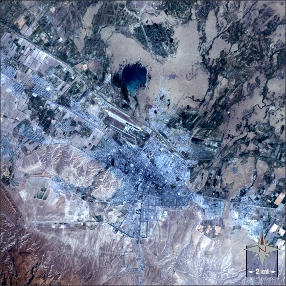
Ashgabat, Turkmenistan lies in an oasis at the northern foot of the Kopet-Dag mountain range on the edge of the Karakum Desert in Central Asia. Ashgabat is the capital of Turkmenistan and the country’s largest city, with over 600,000 residents.
In the 4th century BC on his way to India, Alexander the Great conquered the territory. A hundred and fifty years after Alexander’s conquest, Persia’s Parthian Kingdom established their capital in Nisa, now part of the modern day suburbs of Ashgabat.
Turkmenistan’s government today is concerned with centralizing state control. The ethnic groups that make up modern day Turkmenistan are 85% Turkmen, 5% Uzbek, 4% Russian and 6% other.
This Landsat 7 image of Ashgabat was acquired on August 29, 2002. This is a natural-color image using ETM+ bands 3, 2, and 1. Ashgabat falls on Landsat WRS-2 Path 160 Row 34. Source: NASA
|
Administrative divisions: 5 provinces (welayatlar, singular - welayat) and 1 independent city (Ashgabat):
note: administrative divisions have the same names as their administrative centers (exceptions have the administrative center name following in parentheses)
|
|

Independence Date: 27 October 1991 (from the Soviet Union)
Legal System: civil law system with Islamic law influences. Turkmenistan has not submitted an International Court of Justice (ICJ) jurisdiction declaration; and is a non-party state to the International criminal court (ICCt). Power is concentrated in the president. The judiciary is subservient to the president, with all judges appointed for 5-year terms by the president without legislative review.
Water
Total Renewable Water Resources: 60.9 cu km (1997)
Freshwater Withdrawal: 24.65 cu km/yr (2% domestic, 1% industrial, 98% agricultural)
Per Capita Freshwater Withdrawal: 5,104 cu m/yr (2000)
Access to improved sources of drinking water: 83% of population
Access to improved sanitation facilities: 98% of population
See: Water profile of Turkmenistan
Agriculture
The two largest crops are cotton, most of which is produced for export, and wheat, which is domestically consumed. Although agriculture accounts for roughly 10% of GDP, it continues to employ nearly half of the country's workforce.
Agricultural products: cotton, grain; livestock
Irrigated Land: 18,000 sq km (2008)
Resources
Natural Resources: petroleum, natural gas, sulfur, salt
Land Use:
arable land: 4.51%
Permanent crops: 0.14%
other: 95.35% (2005)
Energy
Outside estimates place Turkmenistan's proven natural gas reserves of 7.94 trillion cubic meters (tcm) among those of the top four of gas-producing countries. A 2008 audit conducted by the British firm Gaffney, Cline and Associates concluded that the three most significant gas fields in the country, Yoloten, Osman, and Yashlar, hold between 4.25 and 15.5 tcm of natural gas.
In 2008, Turkmenistan was the second-largest gas producer in the former Soviet Union after Russia with estimated production around 70 billion cubic meters (bcm). Turkmenistan’s 2009 production declined to about 34 bcm. Gas production declined significantly when exports to Russia stopped on April 9, 2009, following a blast on the Central Asia-Center gas pipeline. Gas exports to Russia resumed at a reduced level (approximately 10.5 bcm/year) and price in January 2010.
Since the end of 2009, Turkmenistan has been exporting natural gas in three directions: to Russia, Iran, and China. In 2010, exports to Russia were expected to total 10-11 bcm, exported through the old pipeline system built during the Soviet era. Gas exports to Iran were expected to reach 7-8 bcm in 2010, exported through two pipelines: Korpeje-Kurtkuyi (built in 1997) and Dowletabat-Sarakhs-Khangiran (built in 2009). The total capacity of the two pipelines is 25 bcm per year, providing room for further increase of exports in the future. At the end of December 2009, Turkmen gas started flowing to China through the newly built Turkmenistan-Uzbekistan-Kazakhstan-China gas pipeline (Central Asia-China pipeline). Turkmen gas exports to China were expected to total 3-4 bcm in 2010. Turkmenistan and China plan to boost gas supplies to 40 bcm by 2014-2015 when the pipeline reaches full capacity.
Turkmenistan's 2009 oil production was about 10.3 million tons and was expected to total 10.4 million tons in 2010. Turkmenistan refines almost all of its oil inside the country and exports only petroleum products such as liquefied petroleum gas (LPG) and polypropylene.
See:
- Energy profile of Central Asia
- Energy profile of the Caspian Sea region
Economy
Turkmenistan is an important supplier of raw materials, especially natural gas, petroleum products, and raw cotton. With the estimated 2009 harvest of about 823,000 tons, Turkmenistan is the second-largest cotton producer in the former Soviet Union after Uzbekistan. However, the crop yield has been steadily declining since independence because of poor irrigation and management practices.
Turkmenistan has taken a cautious approach to economic reform, hoping to use natural gas export revenues to sustain inefficiencies in its economy. The disruption of Turkmen gas exports to Russia in 2009 and a subsequent decrease in global natural gas demand demonstrated the heavy dependence of the Turkmen economy on gas exports.
There are signs that Turkmenistan has a shortage of hard currency reserves. The country's foreign debt has been estimated at $5 billion. The private sector remains underdeveloped, with activity primarily in the food processing, consumer trade, and services sectors. In addition, Turkmenistan's statistics are closely held state secrets, and published GDP and other figures are subject to wide margins of error. Turkmenistan's goal of agricultural "self-sufficiency" artificially sustains the cultivation of inefficient crops, such as wheat and cotton.
The 2006 UN Development Program (UNDP) Human Development Report placed Turkmenistan in the category of "medium human development" although unemployment and underemployment rates may be as high as 70%. Turkmenistan continues to cooperate with the international community to transport humanitarian aid to Afghanistan.
With an authoritarian ex-Communist regime in power and a tribally based social structure, Turkmenistan has taken a cautious approach to economic reform, hoping to use gas and cotton export revenues to sustain its inefficient economy.
Privatization goals remain limited.
From 1998-2005, Turkmenistan suffered from the continued lack of adequate export routes for natural gas and from obligations on extensive short-term external debt. At the same time, however, total exports rose by an average of roughly 15% per year from 2003-08, largely because of higher international oil and gas prices.
New pipelines to China and Iran, that began operation in early 2010, have given Turkmenistan additional export routes for its gas, although these new routes have not offset the sharp drop in export revenue since early 2009 from decreased gas exports to Russia.
Overall prospects in the near future are discouraging because of widespread internal poverty, endemic corruption, a poor educational system, government misuse of oil and gas revenues, and Ashgabat's reluctance to adopt market-oriented reforms.
In the past, Turkmenistan's economic statistics were state secrets. The new government has established a State Agency for Statistics, but GDP numbers and other figures are subject to wide margins of error. In particular, the rate of GDP growth is uncertain.
Since his election, President Berdimuhamedow unified the country's dual currency exchange rate, ordered the redenomination of the manat, reduced state subsidies for gasoline, and initiated development of a special tourism zone on the Caspian Sea.
Although foreign investment is encouraged, and some improvements in macroeconomic policy have been made, numerous bureaucratic obstacles impede international business activity.
GDP: (Purchasing Power Parity): $41.51 billion (2011 est.)
GDP: (Official Exchange Rate): $24.1 billion (2011 est.)
GDP- per capita (PPP): $7,500 (2011 est.)
GDP- composition by sector:
agriculture: 7.8%
industry: 24.1%
services: 68.1% (2011 est.)
Industries: natural gas, oil, petroleum products, textiles, food processing
Currency: Turkmen manat (TMM)