Template:Uvs Nuur Lake
Contents
Uvs Nuur Lake
Author: C. Michael Hogan
Topic Editor: [[]]
Published: September 1, 2017
Topics: Limnology (main)
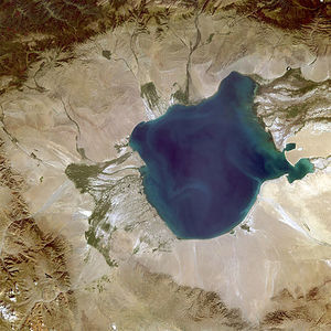
Uvs Nuur Lake is the largest lake in Mongolia with a minor portion extending north into the Tuva Republic of Siberia in Russia. This water body can be considered hypersaline, with differing reports indicating salinity of 0.5 to 3.0 times that of seawater, much variation due to seasonal inflow and evaporation variance. Unlike many highly saline lakes, considerable fish populations are present, due to abundant inflow of freshwater and historic low human exploitation of these waters.
There is a stunning array of habitat types present in the Uvs Nuur basin, including Asia's northernmost desert and its southernmost tundra. Some of the watershed upper slopes even harbour relict glaciers. Several sizable mountain rivers feed Uvs Nuur Lake, whose lower valleys are interspersed with salt pans, smaller lakes, and low hills. Jagged rock outcrops are evident on the main valley floor. Uvs and its nearby sister lakes have margins of by sparsely vegetated desert and even some marshland; in fact, Uvs Nuur Basin boasts the most vast giant reedbeds in Asia. The eastern elements of the watershed floor sport extensive sand dunes.The largest populated area in the vicinity is the town of Ulaangom, 26 kilometres (16 miles) to the southwest, the capital of Mongolia's Uvs Province; this town has a population of about 23,000.
Geology
According to the UNESCO inscription, the Uvs Basin is virtually encircled by mountains: "To the north, the basin transitions into the Tannu-Ola Range, to the east are the Sangilen and Bolnai Ranges; to the west the Tsagaan Shuvuut and Shapshaskee Ranges constitute natural boundaries, while the Turgen Uul and Hanhohee Ranges are adjacent to the south". Some of the peaks of these ranges reach heights more than 4000 m above mean sea level.
The relict glaciers adorning some of the mountains are testimony to the Pleistocene ice sheets. In the Altai range at the west is the sole glacial area of southern Russia. The Uvs Nuur Lake lies within an enormous desert steppe basin, which topographic landform was caused by land depression and uplift, rather than by a rift zone. To the east of Uvs Lake are both stabilised and unstabilised sand dunes along the river terraces.
Basin soils are generally light and skeletal, with extensive useful mineral deposits. Soil types are stratified by elevation, partially responsible for the sharp ecotonal transition between steppe and higher elevation conifer forest. The entire Uvs Nuur Basin is subject to ongoing seismic activity with palpable risk of earthquakes.
Hydrology
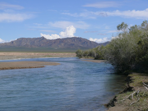
The Uvs Nuur Lake surface area is approximately 3350 km² with an average depth of six metres (m). The elevation of the lake surface is approximately 759 m above sea level. The largest inflow to Uvs Nuur Lake is the Tes River, which rises in northern Mongolia near Tsagaan-Uul, turns north to Russia and re-enters Mongolia coming through the Khangai Mountains before discharging to Uvs Lake along the eastern part of the lake. Also discharging from the east is the Turuun River. Discharging from the west.1
The origin of the lake name is from a Mongolian word ubsen which describes the bitter dregs from the making of a Mongolian milk and lime beverage combined with the Mongolian word for lake, nuur; this lacustrine body is alternatively referred to as Uvs Lake.
Uvs Nuur Lake is typically frozen at the surface from October to May. Summer surface lake temperature is typically 25 degrees C, and bottom waters of 19 degrees C. The chief ions found in the water column of Uvs Nuur Lake are sodium and sulfate.
Climate
The basin can be characterised as a cold semi-arid climate having extended dry, harshly cold winters and abbreviated hot summers2. Annual rainfall amounts to 130 centimetres (5.12 inches). Uvs Nuur Lake basin is thus the coldest locale in Mongolia with winter temperatures descending to −58 °C (−72 °F); summertime highs are about 35 °C (95 °F). The lowest recorded temperature in Central Asia was attained here.
Lake ecology
There are at least 29 different fish taxa found in Uvs Nuur Lake.3 The Potanini altai osman, (Oreoleuciscus potanini) is suitable for human consumption. This omnivorous fish is found in only a small number of lakes and rivers in Russia and Mongolia.
Some of the margins of Uvs along with some of the ancillary marshes and lakes are dominated by expansive reedbeds with the predominate giant grass being Phragmites communis. There are particularly extensive marshes along the lower Tes River on level terrain in a delta area where the Tes discharges to Uvs Nuur Lake. The Tes delta is the sole locale in Mongolia where a the extremely rare lichen Aspicilia esculenta is found, in a narrow zone at the northeastern shore of Uvs Nuur Lake. The Torkhiologiin-Gol delta comprises desert as well as salt flats, plus floating islands of vegetation and floodplains forested with Siberian larch, Siberian spruce (Picea obovata) and Laurel-leaved poplar (Populus laurifolia), forming floating and actual islands where colonies of migrating birds nest, evocative of the famous Danube Delta.
Terrestrial ecology
The Uvs Lake Basin generally falls within the Great Lakes Basin desert steppe ecoregion. A diverse array of plants are found here due to the variegation of habitat types, ranging from desert to steppe and even tundra.4,5 There are over 553 recorded vascular plant taxa present in the Uvs basin, five of which are strictly endemic to this watershed: five are endemic to Uvs Nuur: Asragalus tuvinicus, Astrogalus polozhinae, Juncus salsuginous ssp.tuvinicum, Stipa barhanica, and Zygophyllum pterocaprum ssp.tuvinicum. Desert steppe scrub is dominated by Nanophyton, Salsola passerina, and Artemisia frigida. Reaumuria soongorica in the Tamarisk family and Anabasis spp.(fleshy stemmed succulent subshrubs) dominate in Hyargas while dominant communities in Shargyn consist of Haloxylon ammodendron. Almost half of the total plant taxa here are endemic to the broader zone of the southern Siberian mountains and Mongolia. A total of 173 avian taxa and 41 mammalian species have been reported here.
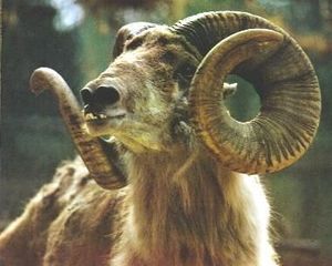
Some of the large mammals in the Uvs Nuur Basin are the Earth's biggest sheep, the Near Threatened Altai Argali (Ovis ammon); the Near Threatened Pallas's Cat (Felis manul); the Endangered Snow Leopard (Uncia uncia)[ and Siberian ibex (Capra sibirica). The last remnant population of Mongolian saiga (Saiga tatarica mongolica) is found here in the desert steppe area.6 There are many important rodent taxa present in the basin playing a key eclogical role; of note are two Vulnerable jerboa and gerbil species. Also present are Tartarian roe-deer (Capreolus pygargus), the Endangered Altai marmot (Marmota baibacina). There are also the Vulnerable musk deer (Moschus moschiferus), and the smaller mammal Mongolian Bobak marmot (Marmota sibirica). Important tundra mammals include Reindeer (Rangifer tarandus); taiga taxa include the Brown bear (Ursnus arctos), the Vulnerable Wolverine (Gulo gulo), the Vulnerable European otter (Lutra lutra), the Endangered Lynx (Felis lynx), Wild Boar (Sus scrofa), Siberian elk (Cervus elaphus songaricus), Western capercaillie (Tetrao urogallus). Steppe forest species include the Vulnerable Red wolf (Cuon alpinus) and the Marbled polecat (Vormela peregusna) and the rare Mongolian gazelle (Procapra gutturosa).
Some of the avian taxa found here are Altai snow-cock (Tetraogallus altaiacus), Bearded and Black vultures (Gypaetus barbatus and Aegypius monarchus). Tundra inhabiting birds of this basin include the Alpine willow-grouse (Lagopus lagopus) and Mongolian plover (Charadrius mongolus). In the taiga element of the basin is found the Tawny owl (Strix aluco). In the mountain of Yamaalig Mountain area, one may see the Booted eagle (Hieraaetus pennatus), and rock partridge (Alectoris graeca) in their nesting. Uvs Nuur is an important bird migration between Siberia and wintering locales in South Asia.
Conservation
the whole of Uvs Nuur Lake and much the surroundings are protected under UNESCO via the designation Uvs Lake Basin.4 The entirety of the lake basin can be considered one of the best preserved steppe landscapes in Eurasia. In the year 2003 UNESCO designated Uvs Lake Basin as a protected area and natural World Heritage Site recognising it as one of the world's largest intact watersheds. This site was inscripted under criteria ix and x of UNESCO; an important element of inscription is the virtually prehistoric continuity of ecological processes in this basin, given its ancient and historic low human population density; lacustrine bodies of very high salinity (e.g. Mono Lake, Dead Sea, Lake Urmia, Lake Assal) are important for their unique ecologies,7 and merit protection and scientific study. Albeit this formal land protection, the watershed is threatened by illegal poaching, growing human population beyond historic norms and by livestock overgrazing. In the original inscription 810,234 hectares belonged in Mongolia and 87,830 hectares lie within Russia.
Human culture and archaeology
Most of the peoples in the basin are nomad pastoralists enhance have had an ongoing small ecological footprint on the basin of Central Asia. A total of over 40,000 archaeological sites line the basin embracing such tribal diversity as Turks, Huns and Scythians. The basin ancient history dates to the Paleolithic, evidenced by kurgens or burial mounds, carved stone steles (not unlike more well known Mayan monuments) and rock petroglyphs and paintings, particularly in the southern part of the Yamaalig Massif.8 More recent cultural and religious heritage includes Buddhist monasteries.
References
- Jon Davies. (2008) Mongolia. International Water Management Institute. Vitja 1. September 2008.
- Bayasgalan Gerelchuluun & Ahn Joong-Bae (2014) ’Air temperature distribution over Mongolia using dynamical downscaling and statistical correction. International Journal of Climatology. 34: 2464 – 2476
- Erdene-Ochir Badarch. (2008) " Uvs Nuur Basin; World Natural Heritage Site. United Nations Institute for Training and Research.
- UNESCO (2003) Uvs Lake Basin World Heritage Site inscription
- K. Buyan-Orshikh. (1978) Flora and vegetation in sand dunes of the great lakes basin. Study on the Flora and Vegetation of the Mongolian People’s Republic. Volume 2. (in Mongolian).
- World Wildlife Fund (2014) Great Lake Basin Desert Steppe Ecoregion. Encyclopedia of Earth. Topic Ed. Mark McGinley
- C.Michael Hogan (2012) Hypersaline Lake. Encyclopedia of Earth. Topic Ed. Mark McGinley
- United Nations Environment Programme-World Conservation Monitoring Centre (UNEP-WCMC) (2008) Uvs Nuur Basin, Russian Federation, Republic of Tuva and Mongolia". Encyclopedia of Earth. Topic Ed. Langdon Clough